Kansas Geological Survey, OGI 14
Originally published in 1957 as Kansas Geological Survey Oil and Gas Investigations 14. This is, in general, the original text as published. The information has not been updated. An Acrobat PDF version (50.2 MB) is also available.
Rocks of Mesozoic age in Kansas are recognized as belonging to the Triassic, Jurassic, and Cretaceous Systems. Mesozoic rocks unconformably overlie Permian strata and are in turn unconformably overlain by Tertiary and Pleistocene deposits; and they are mostly marine deposits, consisting of shale, sandstone, limestone, and chalk, but considerable amounts of nonmarine sandstone and clay are present. There is no commercial production of petroleum from beds of Mesozoic age in Kansas although other minerals, both fuel and nonfuel, have been and are being economically exploited at present.
To show the correlations and stratigraphic relations of Mesozoic rocks in the subsurface in Kansas, three cross sections are presented: one section, east-west, from Washington County to Cheyenne County; another, southeast-northwest, from Kiowa County to Cheyenne County; and the third, north-south, from Cheyenne County to Morton County. Correlation of beds is based mainly on a study of electric logs supplemented by sample study.
Rocks in Kansas between Permian Taloga formation and Jurassic Morrison formation are recognized as belonging to the Triassic Dockum (?) group. These beds, nonmarine in origin, have been identified only in the extreme southwestern part of the state and consist mostly of siltstone and sandstone. Maximum thickness of the group is about 320 feet. Rocks of Jurassic age have been assigned to the Morrison formation, which is present in about the western fifth of the state and only in the subsurface. These beds, probably fluvial in origin, consist of shale, sandstone, limestone, and some chert and anhydrite. The top of the chert beds in the Morrison forms an excellent marker horizon that can be traced over a large part of the Midcontinent region. Maximum thickness of the formation in the state is about 350 feet. The Cretaceous System, in the western two-thirds of the state, is divided into the Comanchean (lower) and Gulfian (upper) Series. Comanchean rocks are subdivided into the Cheyenne sandstone and Kiowa shale. The Cheyenne, predominantly sandstone, is probably nonmarine and unconformably overlies older strata. It attains a thickness of at least 260 feet. The overlying Kiowa shale, which is marine, has a maximum thickness of about 380 feet. The Gulfian Series is divided into six formations, lowest of which is the Omadi formation (Dakota formation in official State Geological Survey of Kansas nomenclature). Omadi is a new formational name for Kansas and is used here in the subsurface in place of the term Dakota. The formation contains three recognizable members (names also new to Kansas nomenclature), Cruise sandstone, Huntsman shale, and Gurley sandstone. Sandstone, shale, and clay are the predominating lithologic types. Omadi is in part marine and in part nonmarine and has a thickness of as much as 400 feet. Overlying the Omadi formation is Graneros shale, which is marine and attains a maximum thickness of about 100 feet. Greenhorn limestone, also marine, overlies Graneros shale and has a maximum thickness of about 100 feet. Carlile shale, about 300 feet of mostly marine strata, has three members, Fairport chalky shale, Blue Hill shale; and Codell sandstone. Next formation above the Carlile is the Niobrara, which is divided into Fort Hays limestone and Smoky Hill chalk. The Niobrara consists of chalk, limestone, and chalky shale and attains a maximum thickness of about 700 feet. Uppermost formation of the Cretaceous in Kansas is the Pierre shale. It may reach thicknesses of as much as 1,600 feet and, like the Niobrara, is marine. Cretaceous strata are unconformably overlain by nonmarine late Tertiary and Pleistocene deposits.
Sedimentary history as interpreted from Mesozoic rocks is closely related to the structural evolution of western Kansas and surrounding regions. Present structure of Mesozoic beds is the result of both Mesozoic and Cenozoic structural movements.
Recently there has been some interest in rocks of Mesozoic age in western and northwestern Kansas for the possibility of their producing commercial quantities of oil and gas. Because of economic potentialities of mineral wealth from rocks of this age, it seems necessary to have an understanding of their relationship to each other as well as to the younger and older strata. It is also desirable to have some knowledge of their age and correlation with similar rocks in adjacent areas.
Several publications of the State Geological Survey of Kansas have called attention to possible economically exploitable minerals, both fuel and nonfuel, in rocks of Mesozoic age. These materials are confined to rocks that are Cretaceous in age. At the present time, however, this mineral wealth, with the exception of clay, is not being used extensively. In addition to this clay at the surface in the Dakota formation (Plummer and Romary, 1947; Plummer and others, 1954), such materials as lignitic coal in the Janssen member of the Dakota (Schoewe, 1952), oil shale of low quality in the Dakota and Pierre formations (Runnels and others, 1952), glass sand in the Cheyenne formation (Nixon and others, 1950; Rose, 1950), cemented sandstone used for concrete aggregate, riprap, building stone, etc., in the Kiowa and Dakota formations (Swineford, 1947), and chalk in the Fort Hays member of the Niobrara formation (Runnels and Dubins, 1949) merit mention.
Rocks of Mesozoic age have, in effect, served as a hindrance or nuisance in drilling for oil and gas in deeper and older Paleozoic beds of central and western Kansas, and little attention has been paid to their possibilities as petroleum producers. Recent discoveries of commercial quantities of oil and gas in rocks of Cretaceous age in adjacent states of Nebraska and Colorado have increased interest in the possibilities of production from rocks of the same age in Kansas. The Denver basin in Nebraska and Colorado, of course, has been a center of major interest since about 1949. Because of the intensive search for petroleum in the Denver basin and because rocks of similar age occur in a similar geologic setting in Kansas, it seems logical to conclude that possibly there are petroleum accumulations in these rocks in Kansas.
At present there is no commercial production of petroleum from beds of Mesozoic age in Kansas. Although many wells have had shows of oil or gas, the only production recorded in Kansas from beds of Mesozoic age was gas from the Goodland field, in Sherman County. Gas was produced for a short time from the basal part of the Pierre shale and upper part of the Niobrara formation of Cretaceous age at a depth of about 1,000 feet.
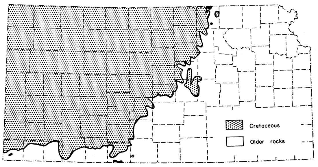
Rocks of Mesozoic age in Kansas are recognized as belonging to the Triassic, Jurassic, and Cretaceous Systems. Triassic rocks are confined to the extreme southwestern part of the state in Morton, Stanton, and Hamilton Counties. Redbeds 40 feet thick, exposed in a small outcrop in Morton County, have been correlated (Moore and others, 1951) with the Dockum (?) group of Triassic age, which crops out in parts of Texas and Oklahoma. Jurassic rocks have been assigned to the Morrison formation and are distributed in the northwestern part of the state west of a line drawn from Smith County to Morton County. These Jurassic rocks occur only in the subsurface and only in the western fifth of the state. Cretaceous rocks cover considerably more area than either the Triassic or Jurassic rocks. Rocks of Cretaceous age occur over about the western half of the state. In Kansas rocks of Comanchean (Lower Cretaceous) and Gulfian (Upper Cretaceous) age are recognized. The main outcrop area of Comanchean rocks is south-central Kansas in Clark, Comanche, and Barber Counties, whereas Gulfian rocks are exposed mainly in the northern half of the state. Comanchean rocks of the state have been divided into two formations, Gulfian rocks into six.
Mesozoic rocks unconformably overlie older Paleozoic rocks and, for the most part, mask the structure of older beds. At different places in the state, Triassic, Jurassic, or Cretaceous rocks overlie Permian strata. Locally, a conglomerate is developed at the base of the Cretaceous System. In turn, rocks of Mesozoic age are unconformably overlain by the Ogallala formation of Pliocene (Tertiary) age or by Pleistocene deposits. Cenozoic rocks mantle the Mesozoic rocks and also serve to mask the structure and stratigraphy of the older beds. Along the valleys of major streams in western Kansas, however, Mesozoic rocks crop out.
Mesozoic rocks in Kansas are mostly marine deposits consisting of shale, sandstone, limestone, and chalk, but considerable amounts of nonmarine sandstone and clay also are present. Minor amounts of lignitic coal, bentonite, chert, and anhydrite occur, and several of these thin beds are important marker horizons. Both megafossils and microfossils are abundant in the marine beds.
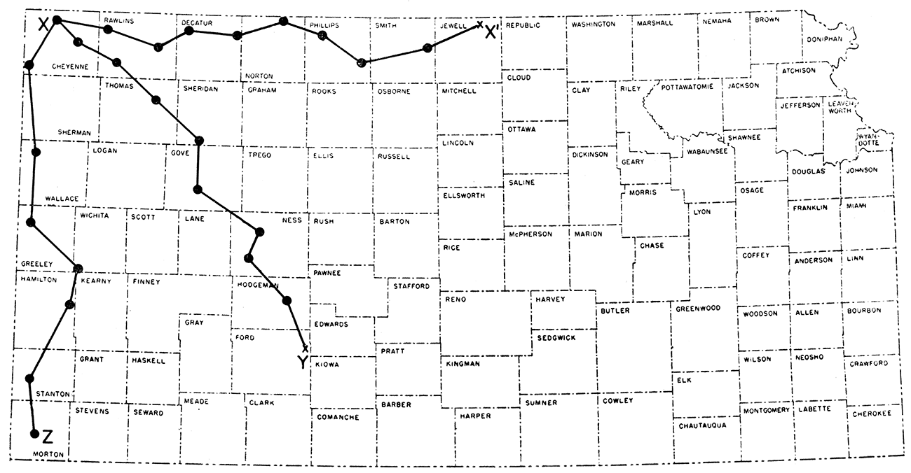
To show correlation and stratigraphic relation of Mesozoic rocks in Kansas, three cross sections are presented. One section extends in an east-west line from Washington County to Cheyenne County (Plate 1); another in a southeast-northwest line from Kiowa County to Cheyenne County (Plate 2); and the third in a north-south line from Cheyenne County to Morton County (Plate 3). All cross sections include the Ohio No. 1 Rose well (sec. 35, T. 1 S., R. 40 W.), which is located in Cheyenne County. Location of these cross sections is shown in Figure 1.
Figure 1—Index map of Kansas showing the location of the cross sections.
Correlation of beds is based on a study of electric log and laterolog surveys supplemented, where possible, by sample study. From several wells no samples were saved, and samples from several other wells were not available to the State Geological Survey. Where possible, sample logs of the Kansas Sample Log Service were used, but many of these samples were re-examined and checked by the author. By necessity, several wells were used that had not been surveyed either by electrical or radioactivity processes.
Datum for the three cross sections is top of the Greenhorn limestone. This particular datum was used because of ease in its identification on most logs and because of its wide geographic extent. Vertical scale of the sections 100 feet to the inch is standard for small-scale logs. Horizontal scale is 6 miles to the inch. This ratio, of course, gives a highly exaggerated picture rather than real relationships; however, this is not of such importance in consideration of stratigraphic cross sections as it is for structural cross sections.
Previous Work
A considerable number of studies of Mesozoic rocks in Kansas have been published, but these works dealt mainly with surface exposures and stratigraphic relation of beds on the outcrop. Listed here are some of the more important works: Early works on the Cretaceous by Prosser (1896), Logan (1896), and Williston (1896) were mainly stratigraphical. These papers were followed shortly by paleontological work by Williston (1898) and Logan (1898). In 1920, Darton published a report on the geology of the Syracuse and Lakin quadrangles. In 1924 Twenhofel published a work on geology and invertebrate paleontology of Comanchean and "Dakota" formations in Kansas. Then, in succeeding years papers dealing with the geology of different western Kansas counties were published by Rubey and Bass (1925), Bass (1926), Wing (1930), Landes (1930), Elias (1931), Moss (1932), Elias (1937), and Landes and Keroher (1939). In the early 1940's the State Geological Survey of Kansas began issuing a series of reports on geology and ground-water resources of western Kansas counties. These reports, which discuss about 35 counties, have added much to the knowledge of surface geology in the western part of the state.
Although a great amount of detailed work on stratigraphy of Mesozoic beds has been published, only a few of these studies are mentioned here. Elias (1931) differentiated members within the Pierre shale by detailed stratigraphic work; Loetterle (1937) published a work on the Niobrara formation, but this was mainly micropaleontological; Hattin (1952) was able to zone the Carlile shale; Bergman (1949) traced the Greenhorn limestone across the state; preliminary work on the Dakota in Nebraska and adjoining states was published by Tester (1929); Plummer and Romary (1942) described the stratigraphy of preGreenhorn beds in Kansas and followed this by a detailed study (1947) of the Dakota formation; Loeblich and Tappan (1950) made a micropaleontological study of the Kiowa shale; Latta (1946) published a work on the Kiowa shale and Cheyenne sandstone of south-central Kansas; Swineford and Williams (1945) described the Cheyenne sandstone in central Kansas; Merriam (1955) wrote a report on the Jurassic Morrison formation; and McLaughlin (1942) described the Triassic Dockum (?) group in Morton County. Lee (1953) shows correlation of Mesozoic beds along the line of a cross section from Meade County to Smith County.
Structure of western Kansas and development during Mesozoic time are discussed in papers by Darton (1905, 1918), Bass (1926), Lee and Merriam (1954), Merriam and Atkinson (1955), and Merriam (1955a).
General information on Mesozoic rocks in Kansas can be obtained from Moore and Landes (1937), Moore, Frye, and Jewett (1944), Jewett (1951), Moore and others (1951), and Merriam and Frye (1954).
I acknowledge the helpful suggestions and criticisms of the cross sections by N. Wood Bass, Thad G. McLaughlin, Stanley W. Lohman, and William A. Cobban, all of whom are with the U. S. Geological Survey, and Eugene C. Reed, State Geologist of Nebraska. Wallace Lee, consulting geologist, kindly read the manuscript critically. I would also like to acknowledge many other benefits that I derived from private discussions with oil company geologists in Kansas, Nebraska, and Colorado.
The Dockum group was named by W. F. Cummins in 1890 (p.189) for exposures near Dockum, Dickens County, Texas. In Texas the group is divided into the Trujillo formation (above) and Tecovas shale (below). The Dockum overlies Permian rocks unconformably and is overlain unconformably by the Blanco formation of Pliocene age (Wilmarth, 1938, p. 616).
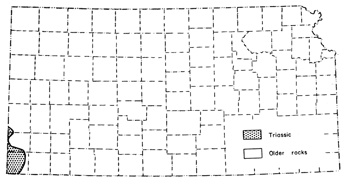
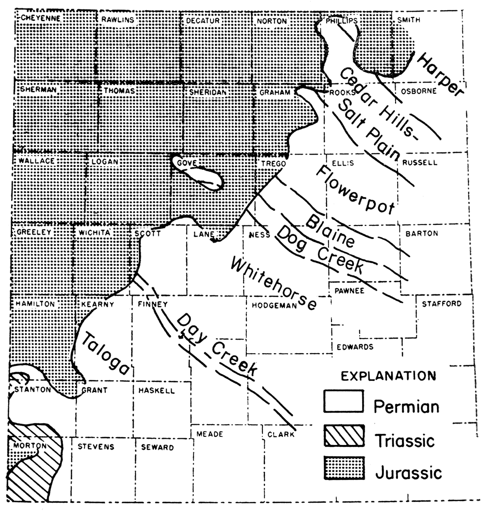
Rocks in Kansas between top of the Permian Taloga formation and base of the Jurassic Morrison formation have been assigned by Moore and others (1951, p. 29) to the Dockum (?) group. These rocks, which consist of redbeds and are regarded as continental in origin, have been traced from Oklahoma and Texas into Kansas. The Dockum (?) group is Triassic in age. No attempt has been made to subdivide this group in the state. Distribution of the Dockum (?) group in Kansas is shown in Figure 2. It is present only in the extreme southwestern part of the state, mainly in Morton and Stanton Counties and also in part of Hamilton County. Both surface and subsurface occurrences of the group are known in Kansas.
Figure 2—Map showing geographic distribution of rocks of Triassic age in Kansas.
These Triassic redbeds are made up of red siltstone, buff, red, and white sandstone', and some gypsum. McLaughlin (1942, p. 70) describes one of two outcrops (sec. 5 and 7, T. 34 S., R. 42 W., and sec. 12, T. 34 S., R. 43 W.) in the state. The section at Point Rock includes 39 feet of sandstone, which is buff, red, gray, brown, orange, yellow, and white, massive, and fine grained, and 3 feet of siltstone. The base of the group is not exposed.
Numerous ground-water test wells have penetrated rocks that have been tentatively assigned to the Triassic. McLaughlin (1942, p. 71) has assigned 320 feet of redbeds in Hamilton County to the Triassic. He states that the contact between Triassic and Permian redbeds is indefinite because rocks of the two systems are similar.
Only one well (well 9, Plate 3) along these three cross sections penetrated Triassic Dockum (?) group. In this well, R. A. Carmody (on a log of the Kansas Sample Log Service) assigned to the Triassic 77 feet of orange-red, very fine-grained, friable sandstone at a depth of 300 to 377 feet. Total thickness of such beds could not be determined in this well because samples started in the Triassic. This sandstone overlies and sharply contrasts with red-brown, micaceous, silty shale of the Permian Taloga formation.
Eldridge in 1896 first named the Morrison formation although the term Morrison was used for equivalent beds in the Pikes Peak area, Colorado, by Cross in 1894 (Wilmarth, 1938, p. 1423). The type section was redefined by Waldschmidt and LeRoy (1944), who recommended that it be an exposure 2 miles north of Morrison, Jefferson County, Colorado. At this type section the Morrison is underlain by the Ralston formation and overlain by the Dakota formation.
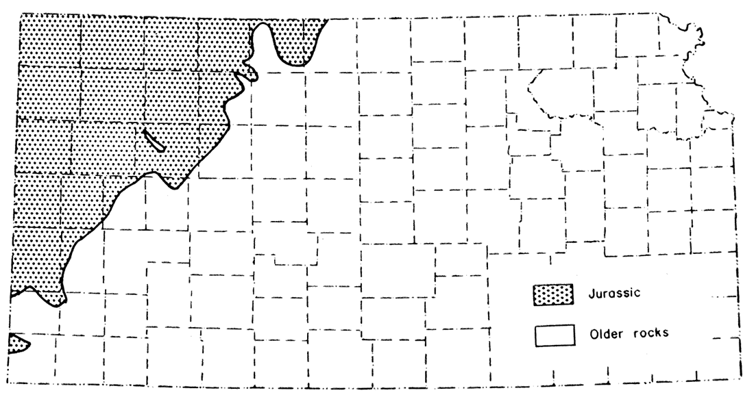
Rocks of Jurassic age in Kansas are represented by the Morrison formation (Merriam, 1955). Imlay (1952) places the Morrison formation in the Upper Jurassic. The formation is present only in the subsurface in about the western fifth of the state (Figure 3). It, consists of shale, sand, limestone, and minor 'amounts of chert and anhydrite. Shale is the predominant lithologic type.
Figure 3—Map showing geographic distribution of rocks of Jurassic age in Kansas.
Two distinctive lithologic units of the formation are recognizable. The upper one consists of sandy shale, which in some places contains stringers of limestone. The lower unit is composed of cherty shale and shale containing anhydrite. Because all of the shale is lithologically similar, these units are recognizable primarily by the associated limestone, chert, and anhydrite.
The Morrison chert is an excellent marker in the Mesozoic rock section. It also has been described in Jurassic rocks in Colorado, Utah, Wyoming, and New Mexico. Ogden (1954) suggests that it may be an altered volcanic ash representing a time-surface marker. If this is true, an excellent correlation tool is available over a wide area in the western Midcontinent region, but no evidence of these chert beds having been altered from volcanic ash in place was found by Ada Swineford (personal communication) in a study of several thin sections. Frederickson, DeLay, and Saylor (1956) suggest the chert beds are zones of secondary concentration of chalcedony by ground water.
Shales are characteristically greenish gray and also have pastel tints of buff, brown, red, and purple. Many beds are silty or sandy, calcareous, and soft. Sand grains are disseminated randomly throughout the shale. Grains are very fine to fine, subrounded to rounded, clear quartz fragments. Small flakes of mica and pyrite are also present, as well as small rounded pellets which resemble siderite pellets that occur in the Dakota. Sandstone is composed of white, fine, subrounded, frosted, loosely cemented quartz grains. The bulk of the sandstone occurs in the basal part of the formation. Limestone is white or light gray, shaly or crystalline, soft to hard, and in places contains small cubes of pyrite. There are all gradations between limy shale and shaly limestone. The limestone seemingly occurs as thin stringers in the shale and is found interstratified in all parts of the formation. Commonly, however, the limestone occurs above the chert. Residues of limestone (after digestion in hydrochloric acid) consist of a very fine, disseminated, matted siliceous material. The chert is pink to white (some has a bluish tint), is generally translucent, and shows a conchoidal fracture. Some of the chert is chalcedonic. The anhydrite is white to pink and crystalline or sugary.
Thickness of the Morrison formation ranges from a featheredge, along a line extending from Smith County to Morton County, to 350 feet in the northwestern corner of the state. Thus, the formation increases in thickness northwestward forming a wedge-shaped mass between the Permo-Triassic and Cretaceous strata. In northwestern Gove County, the Morrison has been completely removed; consequently, Cretaceous beds lie on the Permian. There are two areas of semi-isolated Morrison, one in northwestern Morton County and the other in southeastern Phillips County (Figure 3).
These rocks are probably nonmarine, although their origin is not definitely determined. At the nearest outcrops of the Morrison formation in Oklahoma and southeastern Colorado, the rocks are believed to be fluvial in origin, and inasmuch as the formation in Kansas is similar in lithology and geologic setting, it is assumed to have the same origin.
The chert beds in the Morrison can be traced over a large area, even into Wyoming where they occur in marine upper Sundance. The lower unit of the Morrison in Kansas, therefore, is believed to be equivalent to upper Sundance of Wyoming and possibly Ralston formation of Colorado (LeRoy, 1946). The upper unit of the Morrison in Kansas is probably equivalent to the revised Morrison of the type section as described by Waldschmidt and LeRoy (1944).
The Cretaceous System in Kansas is divided into the Comanchean (lower) and Gulfian (upper) Series. The two series are in turn subdivided into groups, formations, and members. The dividing line between the two series is placed at base of the Omadi formation and top of the Kiowa shale (Cobban and Reeside, 1952). Distribution of Cretaceous rocks in the state is shown in Figure 4.
Figure 4—Map showing geographic distribution of rocks of Cretaceous age in Kansas.
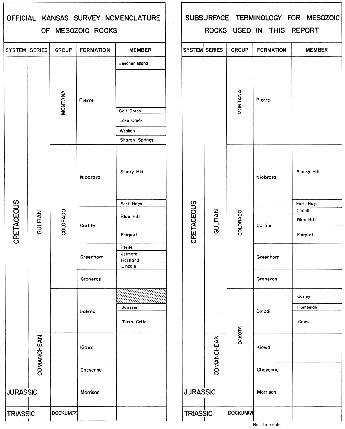
Because of absence of traceable beds and paucity of fossils in some Cretaceous units, correlation from the surface into the subsurface is extremely difficult. This is especially true for beds between the Kiowa shale and the Graneros shale. However, tentative correlations have been made. It has been necessary to use an unofficial terminology for some units in the subsurface until more positive correlations can be made. Figure 5 shows present Kansas Survey classification of Mesozoic rocks and their correlation, or tentative correlation, with subsurface units and terminology. The most obvious difference is in use of the term Dakota, which is used as a formational term on the surface but is tentatively used as a group name for Cheyenne sandstone, Kiowa shale, and Omadi formation in the subsurface. Another minor difference is that the Codell sandstone is treated as a member in the Carlile shale rather than a zone in the Carlile as it has been used in the past.
Figure 5—Chart showing the present official Kansas Survey nomenclature of Mesozoic rocks and equivalent terminology used in the subsurface for the same rock units.
Dakota was a term proposed by Meek and Hayden in 1862 for rock exposures along Missouri River in Dakota County, Nebraska. Subsequently the term has been used in such a manner in recent years that almost complete confusion has resulted. Dakota has been used variously as a formational or group name, expanded or restricted to include more or fewer units than originally defined, miscorrelated, and geographically extended to rock units where correlation has not been possible.
Similarly, in Kansas the term Dakota has been used in various ways by different authors. For example, in the late 1800's Dakota sandstone was classed as a formation with equivalent rank to Cheyenne sandstone and Kiowa shale. In the 1920's, Dakota was used to include strata between Graneros shale and Permian rocks. Thus, the term included not only Dakota sandstone as it had been previously defined, but also Cheyenne and Kiowa formations. The term Dakota group was being used in this sense when the geologic map of Kansas was prepared by Moore and Landes in 1937. According to Waite (1942) a conference of Kansas Survey geologists was held in January 1941, and it was decided that the term Dakota group should include all strata from base of the Cheyenne sandstone to base of the Graneros shale. About this time, Latta (1941) introduced the term Cockrum in southwestern Kansas for beds formerly called Dakota. This classification of the Dakota group proposed by Latta, which included Cheyenne sandstone, Kiowa shale, and Cockrum sandstone, was later used by McLaughlin (1942). However, in February 1942 another conference was held by Kansas Survey geologists, and as a result the term Dakota was restricted to beds between the Kiowa shale and Graneros shale. Since that time, Dakota has held the rank of formation on an equal status with Cheyenne sandstone and Kiowa shale in Kansas Survey usage.
At this second conference several reasons were given for restricting the term Dakota to formational rank. According to Waite (1942, p. 137):
… The group as previously defined, transgressed the Upper Cretaceous-Lower Cretaceous boundary line; a multiplicity of names has existed for the various units involved, many of them having been applied to such nonpersistent units as channel sandstone that cannot be correlated with certainty beyond the confines of their type localities; many of the stratigraphic units were never adequately described. Moreover, the Dakota group, as used previously in Kansas, could not be correlated with the Dakota sandstone at the type locality; it was not acceptable to the Committee on Geologic Names of the U. S. Geological Survey; it did not constitute a satisfactory genetic grouping of strata; and the term Dakota group was confused with other usages of Dakota and almost universally implied a sandstone.
The Cheyenne sandstone was named by F. W. Cragin in 1889 for exposures of sandstone in south-central Kansas. The formation as originally defined included beds between Kiowa shale and strata then called Triassic but now known to be Permian. Later, Cragin divided the formation into several members; however, the proposed names were later discarded by the U. S. Geological Survey as being applied to facies of the Cheyenne.
The formation is the basal unit of the Cretaceous System in Kansas. It is the lower of two formations that in Kansas constitute the Comanchean, or Lower Cretaceous. Cheyenne sandstone, Kiowa shale (Comanchean), and Omadi formation (Gulfian) are included in the Dakota group (Figure 5). Areal distribution of Comanchean rocks is more restricted than that of Gulfian rocks. Best exposed outcrops of Comanchean rocks occur in the Belvidere area and adjoining areas in Barber, Kiowa, Comanche, and Clark Counties in south-central Kansas.
Cheyenne is mainly a light colored, fine- to medium-grained, friable, cross-bedded sandstone containing lenses of sandy shale and conglomerate. Minor amounts of clay, selenite, ferruginous nodules, and pyrite are present in the formation. Sandstone is the dominant rock type. Subsurface samples of the formation consist almost entirely of white, fine to medium, subrounded, frosted, loose or slightly cemented quartz grains. In most samples cement is pyrite or calcium carbonate. At the Champion Draw section (sec. 9, T. 30 S., R. 16 W.) in Kiowa County pebbles and cobbles of quartzite, quartz, and chert are present at base of the Cheyenne sandstone. Thickness of this conglomerate ranges up to 45 feet, according to Latta (1946, p. 237).
Total thickness of Cheyenne sandstone on the outcrop ranges from 33 to 94 feet. In the subsurface, the formation reaches a thickness of at least 260 feet. Abrupt changes in thickness in short lateral distances result from the fact that the formation was deposited on an uneven eroded preCretaceous surface of considerable local relief. In general, the formation thins to the east and south.
Fossil land plants and absence of marine fossils indicate a nonmarine origin for the Cheyenne. The formation supposedly was deposited on or near the strand line of a northward-advancing Cretaceous sea. On basis of the flora (Latta, 1946, p. 241) and other evidence, Cheyenne is correlated with the Fredericksburg or Washita beds of Texas. The Cheyenne sandstone is correlated with the lower member of the Purgatoire formation in the Oklahoma Panhandle by Stovall (1943, p. 74) and in southeastern Colorado by McLaughlin (1954).
Kiowa shale was named by Cragin in 1894 for rock exposures in south-central Kansas. Cragin later redefined Kiowa to exclude the "Champion shell bed" and still later changed the boundary to include the shell bed as the lower part of the formation. This usage of the term has been followed since.
The formation is underlain by Cheyenne sandstone and overlain by the Omadi formation. In some areas where the Cheyenne is missing, Kiowa lies directly on Permian rocks. This shale is the uppermost formation of the Comanchean Series. Best exposed outcrops of the beds are in south-central Kansas in the same vicinity of the Cheyenne sandstone outcrops. The formation is distributed over a slightly larger area than the Cheyenne sandstone.
The formation is predominantly shale. A general description of the shale is medium to dark gray, micaceous, silty, carbonaceous, and soft to hard. Minor amounts of limestone, sandstone, and bentonite also are present. Limestone, which occurs as thin stringers in the shale, is primarily composed of shell fragments. On the outcrop, light-gray limestones containing gypsum or pyrite are commonly less than 18 inches thick (Latta, 1948, p. 87). The "Champion shell bed" (Latta, 1946) occurs at the base of the formation; however, seemingly it is not possible to recognize this bed from well samples. Lenticular light-gray sandstone is composed of fine- to medium-grained quartz fragments. Latta (1948) describes several of these sandstone lenses that occur at different stratigraphic horizons in the formation. Bentonite is white or bluish gray and occurs as thin bands in the shale.
Maximum thickness of the Kiowa along the lines of cross sections is in the vicinity of well 10 on Plate 2. In this well, Kiowa shale is about 380 feet thick. Average thickness is probably about 100 feet. Some of the seeming variation in thickness of the formation is the result of difficulty in determining the upper boundary of the unit. In some areas, it appears as if sandstone in the lower part of the Omadi formation and shale in the upper part of the Kiowa shale interfinger; consequently, an arbitrary limit between the two units is used. Locally an unconformity separates the two formations (Latta, 1948, p. 86).
Kiowa shale is marine as evidenced by marine fossils, both macro- and micro-, found in the formation. Because of abundance of fossils, the unit is easily correlated with equivalent beds in neighboring states. Cobban and Reeside (1952) show Kiowa shale to be equivalent to Glencairn shale member of the Purgatoire formation of eastern Colorado, to Skull Creek shale of Wyoming and Nebraska, and to either Fredericksburg or Washita beds of Texas. The Kiowa is also correlated with a shale member of the Purgatoire formation in the Panhandle of Oklahoma (Stovall, 1942) and in southeastern Colorado (McLaughlin, 1954) .
The term Omadi here is used in place of the term Dakota formation. Omadi was proposed by Condra and Reed in 1943 as an appropriate substitute for Dakota sandstone. It was to include section between Fuson shale and Graneros shale. The type section is in Omadi township, Dakota County, Nebraska, along the Missouri River bluffs. The term was not generally accepted until recently, when Sternberg and Crowley applied the name in the Denver basin to those beds between Graneros shale and Skull Creek shale (Boreing, 1953). In Kansas, Omadi formation includes those beds between top of Kiowa (Skull Creek) shale and base of Graneros shale.
Norman Plummer (written communication, September, 1956) has contributed a summary of the formation as exposed on the outcrops as follows:
The Dakota formation as defined by Plummer and Romary (1942), and adopted for usage by the Geological Survey of Kansas at that time, included the rocks above the Kiowa shale and below the Graneros shale. The formation was divided into the Terra Cotta member below and the Janssen member above. The Janssen member is more regularly bedded than the Terra Cotta and contains fairly persistent beds of silt, lignite, and clay. The clays and sandstones of the Terra Cotta member for the most part occur in lenses and elongated irregular masses, although the clays and silts in the lower part of the Terra Cotta member occur in fairly regular and persistent beds, especially in Ellsworth, Lincoln, and Ottawa Counties. This fact was not discussed by Plummer and Romary (1942), but was mentioned later by Plummer and others (1954). These beds in the lower part of the Terra Cotta are similar in appearance to those in the Janssen member and probably could be classed as a separate member in the area designated.
The upper two-thirds to three-fourths of the Terra Cotta member is an extremely complex unit as observed on the outcrop in Kansas. The most conspicuous rock is the massive gray and red mottled clay which in some places comprise over a hundred feet of the member. Relatively pure clays, lacking the red mottling from ferric oxide, also occur in long narrow masses which are paralleled by similar masses of sandstone. Most of the sandstones appear to be channel, beach, or bar deposits, which if viewed in three dimensions would consist of a complex network of elongated bodies. In one horizontal plane the directional trend is northeast-southwest and in an adjacent plane the directional trend is northwest-southeast. The evidence obtained from test holes along the outcrops of the Dakota formation in Kansas is extremely confusing. One test hole may penetrate more than 100 feet of sandstone, but another drilled at the same elevation and a few hundred yards from the first may penetrate only clay.
Viewed on a larger horizontal scale the surface exposures of the Dakota are not susceptible of easy interpretation. The general appearance of supposedly equivalent beds varies greatly from west to east. The clay mineral content of the clay beds also varies. In general the proportion of kaolinite to illite is greater in eastern Ellsworth County, for example, than it is in southwestern Dickinson County. Similar variations have also been found from southwest to northeast. Clays in the Janssen member in Ellsworth and Washington Counties are commonly more refractory than equivalent beds in Ford, Hodgeman, Barton, Lincoln, and Ottawa Counties. Also the ferric iron content is higher in these same clays in Washington County than it is in their equivalents in Ellsworth County.
The upper and lower limits of the Dakota formation were primarily defined by Plummer and Romary on the basis of lithology. The clays of the Dakota, including those occurring in the sandstones, are predominantly composed of the clay mineral kaolinite and fire to light colors unless contaminated by ferric oxide. The Graneros and Kiowa shale, on the contrary, are predominantly composed of illite and montmorillonite. Experts on the genesis of clays are agreed that kaolinite is most likely to occur in a nonmarine environment where oxidizing, nonalkaline conditions prevail and where leaching is possible. Illite is more likely to be formed (or preserved) under marine conditions. Therefore, the lithological basis of classification is in reality based on the environments of sedimentation, and the clay mineral of the respective members are diagnostic of marine and nonmarine sediments. Plummer and Romary were of the opinion that the Kiowa and Graneros shale formations are marine in origin and that the Dakota formation is predominantly nonmarine.
Omadi formation in the subsurface can be divided into three members that are correlated with divisions recognized in the Nebraska portion of the Denver basin. In ascending order they are: Cruise sandstone, Huntsman shale, and Gurley sandstone.
Although the terms Omadi, Cruise, Huntsman, and Gurley have not been widely used by petroleum geologists, this terminology based on geo- graphic nomenclature has a sounder basis for permanency than that which is based on the alphabet and used by many geologists.
Cruise sandstone—Cruise sandstone is the lowest member of the Omadi formation. It overlies Lower Cretaceous Kiowa formation or Permian beds where the Comanchean is absent. Cruise probably has the largest areal distribution of any of the Cretaceous deposits in Kansas.
The Cruise is mainly a light-gray, gray, or light-brown sandstone consisting of fine- to medium-grained, subrounded, friable, quartz fragments and minor amounts of mica, glauconite, and carbonaceous material. Also there are some siltstone and interbedded shale beds. Shale is medium gray, noncalcareous, soft, and in part clayey. Siderite pellets are present locally. Eastward the member becomes more and more shaly and clayey, and sandstones become finer grained and grade into siltstones. The amount of sand also decreases eastward to such an extent that on the outcrop about three-fourths of the member is clay or shale. Sandstones on the outcrop show evidence of having been deposited as channel-fills.
Thickness of the member is between 100 and 200 feet. It is thickest along the lines of cross sections in the vicinity of well 3 on Plate 1, where it is 400 feet thick. This seemingly abnormal thickness, however, is due in part to the increased amount of sand in the upper part of Kiowa shale; consequently, the boundary between the two units is placed too low.
Fossils indicate that the member is at least in part marine. Correlation of the Cruise sandstone seems to be with the Terra Cotta member of the Dakota formation (described by Plummer and Romary, 1942) in outcrops in north-central Kansas. [Note: Norman Plummer (personal communication) believes from preliminary studies of the clay materials in the Cruise sandstone that possibly they are not equivalent to the Terra Cotta member. Studies indicate that clays in the Cruise are marine whereas clays of the Terra Cotta are nonmarine.] Some or all of these beds may be equivalent to the Cockrum sandstone of southwestern Kansas. Some geologists use the term "J" sandstone for beds that are called Cruise. In this report the Cruise is placed entirely in the Gulfian Series, although the exact position of the boundary between the Lower and Upper Cretaceous along the lines of cross sections is not known. Cobban and Reeside (1952) assign the Omadi (Dakota formation) to Upper Cretaceous.
Huntsman shale—Huntsman shale is the middle member of the Omadi formation. It overlies Cruise sandstone and in turn is overlain by Gurley sandstone. Areal distribution of the Huntsman in Kansas is probably about the same as or slightly less than the Cruise sandstone.
The Huntsman is predominantly shale. It is greenish gray to gray, noncalcareous, micaceous, clayey, or silty. Interbedded with shale are beds of light-gray and micaceous siltstone. Siderite pellets are common and in many places abundant, especially in the clay. The member ranges in thickness along lines of cross section from less than 20 feet to about 90 feet. It is probably nonmarine, for no marine fossils have been reported from it.
The Huntsman is tentatively correlated with the Janssen clay member of the Dakota formation as described by Plummer and Romary (1942). [Note: Additional studies by Plummer (personal communication) on clay material of the Huntsman shale indicate they are identical to the clay material that composes the Janssen member as both are apparently nonmarine.]
Gurley sandstone—Gurley sandstone is the upper member of the Omadi formation and the upper unit of the Dakota group as used herein. Distribution of the Gurley in Kansas is slightly less in area than that of the Cruise and Huntsman members. Generally speaking, the member becomes more shaly both to the east and south.
In extreme northwestern Kansas, the Gurley consists of two sandstones separated by a thin shale unit; however, in other places the member is a series of alternating thin sandstones and shales. Sandstone is composed of light-gray, fine- to medium-grained, subrounded quartz fragments with minor amounts of mica, glauconite, and pyrite. Sand is locally carbonaceous; it may contain streaks of dark-gray to black shale, and in some places the sand is coarse grained and even conglomeratic.
Along the lines of cross section, thickness of Gurley sandstone ranges from a featheredge to about 120 feet. In general, the member thins to the east and south, but over a large area in Kansas it is surprisingly constant in thickness. Near the extremity of the eastern limit of the Omadi in Kansas, Graneros shale seemingly truncates and oversteps the Gurley; consequently, in all probability the member does not crop out in the state.
Because a few marine fossils have been reported from the Gurley, it is believed to be at least in part marine.
The Gurley corresponds to the "D" and "G" sands of the Denver basin. Both Gurley and Huntsman are Gulfian in age (Cobban and Reeside, 1952).
Graneros shale is the basal formation of the Colorado group. It overlies the Dakota group and is, in turn, overlain by Greenhorn limestone. Distribution of this formation is slightly less than that of units of the Dakota group, but at that, it covers about the western two-fifths of the state. The formation contains a bentonite bed that is an excellent marker, traceable over large areas, both in the state and in surrounding regions. The formation is composed primarily of shale.
Graneros is a medium-gray to black, noncalcareous or slightly calcareous silty shale. Locally, it is abundantly fossiliferous containing both vertebrates and invertebrates. Many thin streaks of bentonite are present in the shale, and one in particular, the "Bentonite marker bed", is traceable over large areas and serves to subdivide the formation. In Kansas this marker bed, a bluish-gray bentonite, is 1 to 2 feet thick. It causes an easily identifiable kick on electric logs, west of well 7 on Plate 1. Some lenses of sandstone are present in the Graneros shale.
Along the lines of cross section thickness of the formation ranges from about 40 feet to 100 feet. Generally the formation thickens southward. In the northwestern part of the state, the Graneros has an almost constant thickness of about 40 feet. Outcrops of the formation are found in the north-central part of the state, mainly north of Ford County.
Graneros shale is marine. Numerous marine fossils, both vertebrate and invertebrate, are found in the formation. Oysters and sharks' teeth are the most common forms.
The Graneros or equivalents can be traced into adjacent states of Oklahoma, New Mexico, Nebraska, Colorado, and Wyoming. With detailed work, the "Bentonite marker bed" might be used to indicate exact equivalent beds in the western Midcontinent region. Cobban and Reeside (1952) assign the Graneros to the Gulfian and show graphically correlation and terminology of beds of Graneros age.
On the outcrop, Greenhorn limestone is divided into four members, but they are not recognized in the subsurface in this report. Distribution of the formation is slightly less in area than the Graneros shale. The Greenhorn overlies the Graneros and is overlain by Carlile shale.
The formation consists mostly of limestone and chalky shale. Limestone is gray to light brown, chalky or crystalline, and fossiliferous. Shale is gray to brownish, calcareous, and fossiliferous. In the uppermost part of the formation is a persistent bed known as the "Fencepost limestone". This bed causes an easily identifiable double-pronged kick on electric logs that is traced as far as Wyoming. Because of the easy recognition of this bed, it was used as the datum for all cross sections. Several bentonite beds are present in the formation, and some are traceable over large areas (Bergman, 1949).
Thickness in Kansas is rather constant ranging from about 90 to 100 feet. There is an abundance of marine fossils.
The Greenhorn is identifiable in adjacent states of Oklahoma, Colorado, and Nebraska.
Carlile shale is distributed over about the western third of Kansas. The formation extends east to a line extending from Republic County on the north to Hamilton County on the south. The Carlile is divisible into three members (in ascending order): Fairport chalky shale, Blue Hill shale, and Codell sandstone. Over-all thickness of the formation, about 300 feet, is surprisingly constant in the state, but there is a slight thickening to the east. Carlile is traceable into adjacent states of Colorado and Nebraska.
Fairport chalky shale—The Fairport member is mainly chalky shale containing stringers of limestone. Thin bands of bentonite are present near the base of the member. The Fairport ranges in thickness along lines of cross section from about 80 to 150 feet. Hattin (1952, p. 10) states that on the outcrop the member ranges in thickness from about 85 to 115 feet. Maximum thickness that he cites for the unit is 147 feet in Hamilton County determined from a water well log. The beds contain abundant marine invertebrate fossils.
Blue Hill shale—Blue Hill shale is gray to blue gray, clayey, and noncalcareous. It contains several zones of calcareous concretions that have diameters up to 8 or more feet. These concretionary zones are not recognizable in the subsurface. Thickness of the member ranges from about 50 to 160 feet. A marine fauna is found in the shale.
The two shale members of the Carlile are easily differentiated, both on electric logs and in well samples, because Fairport is very calcareous and Blue Hill is slightly calcareous.
Codell sandstone—Codell sandstone is the upper member of the Carlile shale. Sandstone is brown to gray, fine to medium grained, subangular, and silty. Locally it is a siltstone. Also in places the Codell is represented only by a silty or gritty zone. Normally the Codell is about 25 feet in thickness, but ranges from about 2 to 40 feet.
Niobrara formation overlies Carlile shale and represents the uppermost unit of the Colorado group. The Niobrara underlies about the western fifth of the state west of a line extended from Jewell County to Hamilton County. The Niobrara has two members (in ascending order): Fort Hays limestone and Smoky Hill chalk. The formation consists of chalky shale, chalk, and limestone with some bentonite. In Kansas average thickness is about 600 feet, and it ranges from less than 500 to more than 750 feet. The unit is recognized in adjacent parts of Colorado and Nebraska.
Fort Hays limestone—Fort Hays member is a white to light-gray, chalky, porous, soft, limestone with interbedded calcareous, soft, chalky shale. Some finely crystalline limestone is present. The member is abundantly fossiliferous with microforms. Thickness of the Fort Hays along lines of cross section ranges from about 40 to 90 feet, and its average is probably about 50 feet. The unit seems to thicken slightly east and southeast.
From meager evidence available to the author at this time, it seems that the Fort Hays is slightly older than the Timpas limestone of eastern Colorado. Preliminary correlations using electric logs suggest that the Timpas limestone is equivalent to a portion of the lower part of the Smoky Hill chalk. This tentative conclusion is sustained by Eugene C. Reed (personal communication, December 9, 1955).
Smoky Hill chalk—Smoky Hill chalk is the upper member of the Niobrara formation. The Smoky Hill is not made up entirely of chalk, but consists mostly of a chalky or calcareous shale. This shale is light, medium, or dark gray, mottled, soft, calcareous, and fossiliferous. The member contains many thin seams of bentonite. Fragments of the large clam Inoceramus are abundant in this member.
Along lines of cross section, the member ranges from about 400 to more than 650 feet in thickness. According to Moore and others (1951, p. 24) the member may attain a thickness of 700 feet in Logan County; the average is probably about 550 feet.
Fauna and character of beds of the Smoky Hill member indicate they were deposited in a marine environment.
The Smoky Hill member of the Niobrara formation is correlated in part with the Apishapa shale member of the Niobrara formation of eastern Colorado and part of the Niobrara formation of Wyoming and Nebraska (Cobban and Reeside, 1952).
Pierre shale is the only formation of the Montana group present in Kansas. The formation is restricted to about the northwestern tenth of the state. Pierre shale has been subdivided into six members, but with exception of the basal member, Sharon Springs shale, they are not recognized in the subsurface.
The Pierre is predominantly shale. This shale is light to dark gray, soft, slightly calcareous, micaceous, fissile, and fossiliferous. Sharon Springs member, which is identified on many logs, is dark-gray to black, micaceous, clayey shale. The formation also contains numerous concretionary zones, but they are difficult to recognize in the subsurface. Thin streaks of bentonite are common. Inoceramus fragments are commonly present.
The formation, along lines of cross section, attains a thickness of over 1,100 feet. Pierre shale may exceed 1,600 feet in thickness in the extreme northwestern corner of Kansas; however, thickness of the strata, which-range from a featheredge to 1,600 feet, probably averages about 1,200 feet.
Pierre shale is marine in origin as evidenced by marine fossils.
Pierre shale is present in adjacent parts of Nebraska and Colorado (Cobban and Reeside, 1952) .
Triassic Dockum (?) group unconformably overlies the Permian Taloga formation. The interval of time represented by this hiatus is believed to be of considerable length. It is not known whether or not the present limits of the Dockum (?) group are depositional or erosional; however, part of the deposits probably were eroded prior to the deposition of the Jurassic Morrison formation. Inferred pre-Dockum areal geology is shown in Figure 6. Outcrop pattern of the Permian formations is controlled by configuration of the Hugoton embayment of the Anadarko basin. The surface on which the Triassic was deposited was probably beveled and had a low topographic relief. There is no knowledge of a conglomerate occurring at the Permo-Triassic boundary that would indicate relatively high land in the immediate vicinity of southwestern Kansas. Marine conditions, which had prevailed in the Permian, were no longer present and Triassic beds were deposited in a nonmarine environment. Erosion of the Permo-Triassic surface developed a certain degree of relief by time of deposition of the Jurassic Morrison formation. Inferred pre-Morrison areal geology is shown in Figure 7.
Figure 6—Map of western Kansas showing the inferred pre-Triassic areal geology.
Figure 7—Map of western Kansas showing the inferred pre-Jurassic areal geology.
Jurassic Morrison formation was deposited unconformably on the Permo-Triassic surface. Topographic relief of this surface was at least 110 feet (Lee and Merriam, 1954, p. 14). Distribution of clastic material in the formation indicates that the source of sediments was to the southeast. Hence, direction of stream flow must have been northwesterly. Because these streams flowed on a surface of low relief, they were sluggish and carried only fine-grained sediments, Small lakes and backwater areas must have developed on low, flat, marginal areas. Deltaic conditions existed near the southeastern margin of the depositional area.
A study of distribution of units of the Morrison formation reveals that each successively younger rock type extends farther east, forming an overlap relationship on the Permo-Triassic surface. Present erosional limits of the formation are probably fairly close to original depositional limits. This overlap relation is indicated plainly between wells 4 and 7 on Plate 1. Farther south, as shown by Plates 2 and 3, the Morrison was eroded enough to destroy all evidence of overlapping relationships. After deposition of the Morrison, a hiatus of considerable length followed. Inferred pre-Cretaceous areal geology is shown in Figure 8.
Figure 8—Map of western Kansas showing the inferred pre-Cretaceous areal geology.
Initial Cretaceous deposition was on the irregularly eroded Permo-Trias-Jurassic surface. Merriam (1955, p. 40) shows configuration of this surface as consisting primarily of two major north-south trending valleys with numerous minor tributaries. One of these valleys extended from eastern Rawlins County through eastern Thomas, western Gove, and Lane to eastern Finney County. The easternmost valley extended from western Phillips County through western Rooks, Trego, and part of Ellis to Rush County. Locally, there was more than 400 feet bf topographic relief on this surface. These large topographic features, until they were filled, must have exerted considerable influence on deposition of lower Cretaceous sediments.
A conglomerate at the base of the Cretaceous beds consists of pebbles and cobbles just above the unconformity. It is considered to be part of the Cheyenne, Kiowa, or Omadi formations depending on which is the lowest Cretaceous stratigraphic unit present. 'Pebbles consist of igneous and metamorphic rocks and chert, with quartzite and chert predominating. On the basis of fossils in the chert, the conglomerate is presumed to have come from the northeast (Moore and others, 1951, p. 28).
Cheyenne sandstone (Lower Cretaceous) was deposited on the eroded pre-Cretaceous surface. It is natural to assume that the first deposition took place in topographically low areas and that as sedimentation continued valleys were filled and sedimentation eventually extended over the divides. One of these large filled valleys is shown on Plate 1, wells 6 to 8. As the Cretaceous sea advanced from the south, the strand line probably oscillated. Gradually, these conditions gave way to a completely marine environment in Kiowa time. To the east, land was still high enough to prevent accumulation of early Cretaceous deposits. As the sea swept in from the south and the basin became deeper, deposition extended farther north and east. Thus, sediments were in an overlapping relation on the pre-Cretaceous surface, each younger deposit extending farther to the north and east.
By beginning of deposition in Omadi time, most irregularities of the pre-Cretaceous surface had been filled and the sea floor had become relatively smooth; however, there were minor irregularities (Plummer and Romary, 1942, p. 325). Conditions slowly changed and deposition of sand began. Locally, as marine and nonmarine conditions shifted, the upper part of the Kiowa shale and the lower part of the Omadi formation became interbedded. Locally, conditions must have changed from marine to near marine to nonmarine many times during deposition of the Omadi. End of Omadi time was marked by readvance of the Cretaceous sea over the area. It is especially evident along the marginal areas that marine planation truncated part of the Omadi sediments. This is indicated on the cross sections between well 10 and section 11, Plate 1; wells 8 and 9, Plate 2; and wells 6 and 7, Plate 3.
The Graneros shale was deposited with return of marine conditions. Volcanic eruptions added layers of ash, now altered to bentonite. As the basin subsided (or the water deepened), Greenhorn limestones and limy shales were laid down. Volcanoes were still active and contributed to the sediments. Conditions again changed with deposition of the Fairport shale. Hattin (1952, p. 20) believes that this shale was deposited during a period of areally restricted sedimentation and that silt present in this member was wind transported. Deposition of the Blue Hill occurred at a time of shallower water and probably far from high lands as evidenced by absence of coarse clastic particles such as those present in the Fairport member. Volcanoes were still active during time of deposition of the Carlile shale and supplied quantities of material to the sediments. Deposition of the Codell sandstone followed.
Deposition of the Fort Hays limestone indicates a marine environment. A change of conditions resulted in deposition of the Smoky Hill chalk. Volcanic activity must have been at a maximum at this time as revealed by the many bentonite beds that occur in the Niobrara. Following Niobrara time, the Pierre was deposited and evidence of many ash falls recorded. Sometime after close of deposition of Pierre shale in Kansas, the area was tilted into the Denver basin, and Cretaceous beds were elevated, eroded, and beveled. It is impossible to ascertain the eastern limit of Cretaceous deposition because all evidence of marginal areas of the Cretaceous seaway in the state since has been removed by erosion. In post-Pierre time amount of material removed by erosion from Kansas must have been considerable and probably supplied material for sediments elsewhere. A considerable interval elapsed from the end of Pierre time until deposition of the upper Tertiary Ogallala formation.
The Ogallala formation was deposited on the unevenly eroded pre-Pliocene surface by easterly flowing streams from the re-elevated Rocky Mountains. Volcanic activity was still being recorded in the Pliocene and continued until recent time. The bulk of volcanic material in Mesozoic rocks of western Kansas probably was derived from the Rocky Mountain and Cordilleran regions west of the state.
Because of limited areal extent of Triassic Dockum (?) group in Kansas, it is not possible to construct a regional structure map on a datum in that group of beds.
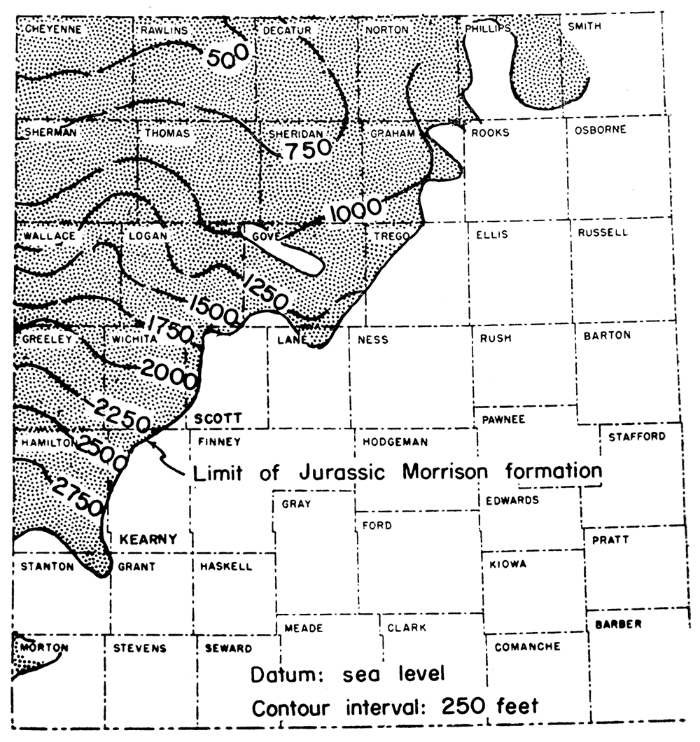
Present structure on a datum in the Morrison formation is shown in Figure 9. Structural contours, at 250-foot intervals above sea level, were drawn on top of the chert beds to show regional structure. Top of the chert was used as a datum for the structural map because it is the only persistent recognizable horizon in the Morrison and because both lower and upper boundaries are erosional. Structure on the Morrison formation corresponds, in general, with present structure on top of the Omadi, Carlile, and Niobrara formations. Regional dip of the Morrison is toward the north where the chert horizon drops about 2,500 feet between central Hamilton County and northern Cheyenne County along the Kansas-Colorado state line. A large syncline, plunging northwest, is present in Sheridan, Decatur, and Rawlins Counties. A large prominent structural nose is located in Wallace, Logan, Sherman, and Thomas Counties and plunges northeast.
Figure 9—Map of western Kansas depicting the regional structure on top of the chert beds in the Morrison formation.
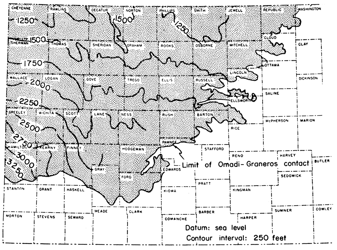
Structure on top of the Omadi formation (Figure 10) is representative of structure of Cretaceous beds in western Kansas. Structural contours are drawn at 250-foot intervals, and datum is sea level. Although top of the Omadi may be truncated in certain areas, it was probably nearly level before deposition of the Graneros shale and thus should reveal regional structure. Several major structures are evident on the map: Cambridge arch, possibly the Salina basin, eastern edge of the Las Animas arch, and adjacent marginal syncline. The southerly plunging Cambridge arch and Jennings anticline, a subsidiary feature, are revealed by the 1,500-foot contour in Decatur and Norton Counties. The structurally low area in Phillips and Smith Counties is possibly a reflection of the earlier-formed Salina basin. The marginal syncline., developed in Thomas, Gove, Scott, and Finney Counties, corresponds partly in area to the older Oakley anticline. West of this syncline contours outline the eastern side of the Las Animas arch. The Central Kansas uplift and Hugoton embayment, both structures long dominant, are not revealed by structure on this horizon. Over-all regional dip on top of the Omadi formation is northward.
Figure 10—Map of western Kansas depicting the regional structure on top of the Omadi formation.
Structure on datum horizons in Mesozoic beds reveals only structural movements that occurred after their deposition. Because these movements were of a different nature from previous older ones, major Paleozoic post-Mississippian structural provinces of. Kansas are not revealed by structure on Mesozoic beds.
Evidence for structural movement during the Triassic is meager. It is, however, possible that there was some structural adjustment along the Oakley anticline at this time. During Jurassic time, the area was tilted northwest into the Denver basin. The Cambridge arch, topographically high at beginning of Jurassic deposition, was overlapped and finally buried by sediments of the Morrison formation. Before deposition of lower Cretaceous sediments, the area was tilted slightly southward.
Little structural movement actually took place during the Cretaceous Period, with exception of formation of the marginal syncline in western Gove and eastern Thomas Counties. This syncline developed on the earlier Oakley anticline and almost completely destroyed it (Lee and Merriam, 1954). Slight movement occurred on the Cambridge arch. Differential movement continued until some time after deposition of the Niobrara, possibly at the end of the Cretaceous when sediments of the area were tilted northwestward into the Denver basin and folded.
After deposition of the "Algal limestone", which occurs at the top of the Ogallala formation, the area was tilted to the east (Merriam and Frye, 1954). This movement concluded structural development of western Kansas to the present and brought beds into their present position.
Bass, N. W. (1926) Geologic investigations in western Kansas, with special reference to oil and gas possibilities: Kansas Geol. Survey Bull. 11, p. 1-96. [available online]
Bergman, Denzil W. (1949) The Greenhorn limestone in Kansas: unpublished master's thesis, Kansas State Coll., p. 1-72.
Boreing, M. J. (1953) Geology of the Denver basin: Proc. 3rd Subsurface Geol. Symposium, Univ. Oklahoma, Norman, p. 72-81.
Cobban, William A., and Reeside, John B., Jr. (1952) Correlation of the Cretaceous formations of the western interior of the United States: Geol. Soc. America Bull., vol. 63, p. 1011-1044.
Condra, G. E., and Reed, E. C. (1943) The geological section of Nebraska: Nebraska Geol. Survey Bull. 14, p. 1-82.
Cragin, F. W. (1894) Descriptions of invertebrate fossils from the Comanche Series in Texas, Kansas, and Indian Territory: Colorado Coll. Studies, 5th Ann. Publ., p. 49-68.
Cragin, F. W. (1889) Contributions to the Palaeontology of the Plains, No. 1: Washburn Laboratory of Natural History Bull., vol. 2, no. 10, p. 65-68.
Cross, Whitman (1894) Pikes Peak Folio, Colorado: U. S. Geol. Survey Geologic Atlas 7, p. 1-5. [available online]
Cummins, W. F. (1890) The Permian of Texas and its overlying beds: Texas Geol. Survey, 1st Ann. Rept., p. 183-197.
Darton, N. H. (1905) Preliminary report on the geology and underground water resources of the Central Great Plains: U. S. Geol. Survey Prof. Paper 32, p. 1-433. [available online]
Darton, N. H. (1918) The structure of parts of the Central Great Plains: U. S. Geol. Survey Bull. 691a, p. 1-26. [available online]
Darton, N. H. (1920) Syracuse and Lakin Quadrangles, Kansas: U. S. Geol. Survey Geologic Atlas 212, p. 1-10. [available online]
Elias, Maxim K. (1931) The geology of Wallace County, Kansas: Kansas Geol. Survey Bull. 18, p. 1-254. [available online]
Elias, Maxim K. (1937) Geology of Rawlins and Decatur Counties, with special reference to water resources: Kansas Geol. Survey Mineral Resources Circ. 7, p. 1-25. [available online]
Emmons, Samuel F., Cross, Whitman, and Eldridge, George H. (1896) Geology of the Denver basin: U. S. Geol. Survey Monograph 27, p. 1-556. [available online]
Frederickson, E. A., DeLay, J. M., and Saylor, W. W. (1956) Ralston formation of Canon City embayment, Colorado: Am. Assoc. Petroleum Geologists Bull., vol. 40, p. 2120-2148,
Hattin, Donald E. (1952) The megascopic invertebrate fossils of the Carlile shale of Kansas: unpublished master's thesis, Univ. Kansas, p. 1-122.
Imlay, Ralph W. (1952) Correlation of the Jurassic formations of North America, exclusive of Canada: Geol. Soc. America Bull., vol. 63, p. 953-992.
Jewett, John M. (1951) Geologic structures in Kansas: Kansas Geol. Survey Bull. 90, pt. 6, p. 105-172. [available online]
Kansas Geological Society (1955) Southwestern Kansas: Kansas Geol. Soc. Guidebook, 18th Field Conference, p. 1-118.
Landes, Kenneth K. (1930) The geology of Mitchell and Osborne Counties, Kansas: Kansas Geol. Survey Bull. 16, p. 1-55. [available online]
Landes, Kenneth K., and Keroher, Raymond P. (1939) Geology and oil and gas resources of Logan, Gove, and Trego Counties, Kansas: Kansas Geol. Survey Mineral Resources Circ. 11, p. 1-45. [available online]
Latta, Bruce F. (1941) Geology and ground-water resources of Stanton County, Kansas: Kansas Geol. Survey Bull. 37, p. 1-119.
Latta, Bruce F. (1946) Cretaceous stratigraphy of the Belvidere area, Kiowa County, Kansas: Kansas Geol. Survey Bull. 64, pt. 6, p. 217-260. [available online]
Latta, Bruce F. (1948) Geology and ground-water resources of Kiowa County, Kansas: Kansas Geol. Survey Bull. 65, p. 1-151. [available online]
Lee, Wallace (1953) Subsurface geologic cross section from Meade County to Smith County, Kansas: Kansas Geol. Survey Oil and Gas Investi. No. 9, p. 1-23. [available online]
Lee, Wallace, and Merriam, Daniel F. (1954) Preliminary study of the structure of western Kansas: Kansas Geol. Survey Oil and Gas Investi. No. 11, p. 1-23. [available online]
LeRoy, L. W. (1946) Stratigraphy of the Golden-Morrison area, Jefferson County, Colorado: Colorado School Mines Quar., vol. 41, no. 2, p. 47-69.
Loeblich, Alfred R., Jr., and Tappan, Helen (1950) Foraminifera of the type Kiowa shale, Lower Cretaceous, of Kansas: Univ. Kansas Paleon. Contri., Protozoa, art. 3, p. 1-15. [available online]
Loetterle, Gerald J. (1937) The micropaleontology of the Niobrara formation in Kansas, Nebraska, and South Dakota: Nebraska Geol. Survey Bull. 12, p. 1-73.
Logan, W. N. (1896) The Upper Cretaceous of Kansas: Univ. Geol. Survey of Kansas, vol. 2, p. 195-234. [available online]
Logan, W. N. (1898) The invertebrates of the Benton, Niobrara, and Fort Pierre groups: Univ. Geol. Survey of Kansas, vol. 4, p. 431-586.
McLaughlin, Thad G. (1942) Geology and ground-water resources of Morton County, Kansas: Kansas Geol. Survey Bull. 40, p. 1-126. [available online]
McLaughlin, Thad G. (1954) Geology and ground-water resources of Baca County, Colorado: U. S. Geol. Survey Water-Supply Paper 1256, p. 1-232. [available online]
Meek, F. B., and Hayden, F. V. (1862) Descriptions of new Lower Silurian, (Primordial), Jurassic, Cretaceous, and Tertiary fossils, collected in Nebraska: Philadelphia Acad. Nat. Sci. Proc., vol. 13, p. 415-447.
Merriam, Daniel F. (1955) Jurassic rocks in Kansas: Am. Assoc. Petroleum Geologists Bull., vol. 39, p. 31-46.
Merriam, Daniel F. (1955a) Structural development of the Hugoton embayment: Proc. 4th Subsurface Geol. Symposium, Univ. Oklahoma, Norman, p. 81-97.
Merriam, Daniel F., and Atkinson, William R. (1955) Tectonic history of the Cambridge arch in Kansas: Kansas Geol. Survey Oil and Gas Investi. No. 13, p. 1-28. [available online]
Merriam, Daniel F., and Frye, John C. (1954) Additional studies of the Cenozoic of western Kansas: Kansas Geol. Survey Bull. 109, pt. 4, p. 49-64. [available online]
Moore, Raymond C., Frye, John C., and Jewett, John M. (1944) Tabular description of outcropping rocks in Kansas: Kansas Geol. Survey Bull. 52, pt. 4, p. 137- 212. [available online]
Moore, Raymond C., Frye, J. C., Jewett, J. M., Lee, Wallace, and O'Connor, H. G. (1951) The Kansas rock column: Kansas Geol. Survey Bull. 89, p. 1-132. [available online]
Moore, Raymond C., and Landes, Kenneth K. (1937) Geologic map of Kansas: Kansas Geol. Survey.
Moss, Rycroft G. (1932) The geology of Ness and Hodgeman Counties, Kansas: Kansas Geol. Survey Bull. 19, p. 1-48. [available online]
Nixon, E. K., Runnels, R. T., and Kulstad, R. O. (1950) The Cheyenne sandstone of Barber, Comanche, and Kiowa Counties, Kansas, as raw material for glass manufacture: Kansas Geol. Survey Bull. 86, pt. 3, p.41-84. [available online]
Ogden, Lawrence (1954) Rocky Mountain Jurassic time surface: Am. Assoc. Petroleum Geologists Bull., vol. 38, p. 914-916.
Plummer, Norman, and Romary, John F. (1942) Stratigraphy of the pre-Greenhorn Cretaceous beds of Kansas: Kansas Geol. Survey Bull. 41, pt. 9, p. 313- 348. [available online]
Plummer, Norman, and Romary, John F. (1947) Kansas clay, Dakota formation: Kansas Geol. Survey Bull. 67, p. 1-241.
Plummer, Norman, Swineford, Ada, Runnels, R. T., and Schleicher, J. A. (1954) Chemical, petrographic, and ceramic properties of four clays from the Dakota formation in Kansas: Kansas Geol. Survey Bull. 109, pt. 10, p. 153-216. [available online]
Prosser, Charles S. (1896) The Upper Permian and the Lower Cretaceous: Univ. Geol. Survey of Kansas, vol. 2, p. 51-194. [available online]
Rose, Kenneth E. (1950) Silica sand from south-central Kansas for foundry use: Kansas Geol. Survey Bull. 86, pt. 4, p. 85-104. [available online]
Rubey, W. W., and Bass, N. W. (1925) The geology of Russell County, Kansas, with special reference to oil and gas resources: Kansas Geol. Survey Bull. 10, pt. 1, p. 1-86. [available online]
Runnels, Russell T., and Dubins, Ira M. (1949) Chemical and petrographic studies of the Fort Hays chalk in Kansas: Kansas Geol. Survey Bull. 82, pt. 1, p. 1-36. [available online]
Runnels, Russell T., Kulstad, R. O., McDuffee, C., and Schleicher, J. A. (1952) Oil shale in Kansas: Kansas Geol. Survey Bull. 96, pt. 3, p. 157-184. [available online]
Schoewe, Walter H. (1952) Coal resources of the Cretaceous System (Dakota formation) in central Kansas: Kansas Geol. Survey Bull. 96, pt. 2, p. 69-156. [available online]
Stovall, J. W. (1943) Stratigraphy of the Cimarron Valley (Mesozoic rocks): Oklahoma Geol. Survey Bull. 64, p.43-100.
Swineford, Ada (1947) Cemented sandstones of the Dakota and Kiowa formations in Kansas: Kansas Geol. Survey Bull. 70, pt. 4, p. 53-104. [available online]
Swineford, Ada, and Williams, Harold L. (1945) The Cheyenne sandstone and adjacent formations of a part of Russell County, Kansas: Kansas Geol. Survey Bull. 60, pt. 4, p. 101-168. [available online]
Tester, Allen C. (1931) The Dakota stage of the type locality: Iowa Geol. Survey, vol. 35, p. 195-332.
Twenhofel, W. H. (1924) The geology and invertebrate paleontology of the Comanchean and "Dakota" formations of Kansas: Kansas Geol. Survey Bull. 9, p. 1-135. [available online]
Waite, Herbert A. (1942) Geology and ground-water resources of Ford County, Kansas: Kansas Geol. Survey Bull, 43, p. 1-250. [available online]
Waldschmidt, W. A., and LeRoy, L. W. (1944) Reconsideration of the Morrison formation in the type area, Jefferson County, Colorado: Geol. Soc. America Bull., vol. 55, p. 1097-1114.
Williston, S. W. (1896) The Kansas Niobrara Cretaceous: Univ. Geol. Survey of Kansas, vol. 2, p. 235-246. [available online]
Williston, S. W. (1898) The Upper Cretaceous of Kansas: Univ. Geol. Survey of Kansas, vol. 4, p. 28-412.
Wilmarth, M. Grace (1938) Lexicon of geologic names of the United States: U. S. Geol. Survey Bull. 896, p. 1-2396. [available online]
Wing, Monta E. (1930) The geology of Cloud and Republic Counties, Kansas: Kansas Geol. Survey Bull. 15, p. 1-51. [available online]
It is believed by the author that the value of the cross sections is increased if some explanation is offered in regard to placement of formational boundaries in different wells in addition to pointing out some of the irregularities as well as consistencies of rock units. These comments should help the reader better evaluate correlation of different units as presented on the cross sections.
A log from the Kansas Sample Log Service was available for this well, and samples were re-examined by the author. First samples are at a depth of 343 feet, and they are Pierre shale. Rock section directly overlying the Fort Hays limestone, in the lower part of the Smoky Hill shale, seems to be short by about 30 feet. Over-all thickness of the Niobrara formation in well 1 also is less than in well 2. It is possible that this shortening is caused by a normal fault with small displacement located just above the top of the Fort Hays. The "Bentonite marker bed" is evident on the electric log, and below this bed Graneros shale seemingly is more limy than usual. The Graneros-Omadi contact is sharp. The "D" and "G" sands of the Denver basin terminology are both present in the Gurley between base of Graneros shale and top of Huntsman shale. Cruise sandstone ("J" sand) consists of alternating beds of sandstone and shale. Base of the Cruise is clearcut as is the top of the Cheyenne sandstone. The Cheyenne-Morrison contact also is easy to pick on basis of the electric log alone; however, it is not possible to determine top of the Morrison chert beds without aid of samples. Limestone is present in the Morrison formation above the chert beds.
A log from the Kansas Sample Log Service was available for this well, but samples were not examined by the author as rock sections are similar in both wells. Samples, at a depth of 90 feet, start in alluvial material; Pierre shale was encountered at a depth of 350 feet.
A log from the Kansas Sample Log Service was available for this well, and samples were re-examined by the author. Samples at 1,820 feet start in the Omadi formation. Graneros shale is thinner than in wells 1 and 2, but the "Bentonite marker bed" is still discernible. Base of the Cruise sandstone would be difficult to determine from an electric log alone; however, a study of samples reveals a black, micaceous shale about 30 feet thick in the interval shown as Kiowa. It is mainly on this basis that the Cruise-Kiowa contact is placed so low. One explanation for this abnormal thickness of Cruise could be that the upper part of the Kiowa shale has become more sandy. Nearby wells on either side of well 3 seemingly confirm this because sand is present in the Kiowa shale. If this is the case, then possibly the contact should be about 80 feet higher in a position so indicated. The anomalous kick on the resistivity scale just below the Kiowa-Cheyenne contact seems to be caused by a lime-cemented sandstone in the Cheyenne. Base of the Morrison formation would be difficult to locate exactly without sample study. The reason this contact may be difficult to determine is that Permian redbeds just below the contact with Mesozoic beds commonly have been leached.
A log from the Kansas Sample Log Service was available for this well, and samples were re-examined by the author. Samples at a depth of 1,200 feet start in Carlile shale. First evidence of a limestone near top of the Fairport chalky shale is observable. The "Bentonite marker bed" is still present in this well. Kiowa shale has distinct boundaries, although three sands are present in the formation. The Cheyenne is considerably thinner and the Morrison thicker in this well than in well 3.
A log from the Kansas Sample Log Service was available for this well, and samples, which at 160 feet start in the Niobrara formation, were re-examined by the author. The sample log does not match the electric log, and it appears that unfortunately the samples were mixed up. Top of the Niobrara is not evident on the electric log. Character of the electric log is different from that of previously mentioned electric logs for the Fort Hays limestone and Codell sandstone interval. Limestone near the top of the Fairport chalky shale is evident on the electric log. The "Bentonite marker bed" in the Graneros shale is present. The top sandstone bed, which is observable in well 4 just below the Graneros-Omadi contact, seemingly is absent in this well and farther east in other wells along the cross section. Thus, Gurley sandstone is thinner in this well than in other wells to the west. The Kiowa shale is thin. Position of the top of the chert beds in the Morrison is inferred because of condition of the samples, although chert is present. The Morrison-Permian contact is also inferred, but believed to be nearly correct.
A log from the Kansas Sample Log Service was available for this well, and the author re-examined the samples, which start in Niobrara formation. First samples come from a depth of 344 feet. Unfortunately, samples were taken at 30-foot intervals, and there were several hundred feet of missing samples, which seemingly had been lost after the well was logged by the Kansas Sample Log Service. Both lower and upper parts of the Fairport chalky shale are more limy. Graneros shale is thinner than in well 5, and this is the farthest log east on which the "Bentonite marker bed" is discernible on electric logs along this cross section line. Huntsman shale appears to be thicker and Kiowa shale thinner. The Morrison has thinned considerably and the chert beds are not present.
The lower part of the Morrison formation is overstepped between wells 5 and 6, and only the upper part of the Morrison is present in well 6. The interval between top of Permian redbeds and Stone Corral formation (mainly anhydrite) is large in this well.
A log from the Kansas Sample Log Service was available, and the author re-examined the samples, which start at 700 feet. First samples are Carlile shale. The "Bentonite marker bed" is no longer distinguishable in Graneros shale. It is possible that either this is the easternmost extent of the bed or it has become too thin to be picked up with electrode spacing of the electric logger. Huntsman shale seemingly is thickening, although boundaries are difficult to determine. In the Huntsman interval in this well, samples consist mostly of siderite pellets. Cruise sandstone rests on Permian redbeds.
Samples starting at a depth of 200 feet were examined by the author. They were Carlile shale. The Niobrara was not observed in this well. The Huntsman interval was again determined mostly on the siderite pellet zone. In general, the whole of Omadi formation seemingly consists mostly of clay this far east. However, this is difficult to determine, because clay is taken up in the drilling mud and seldom is observed in samples. Kiowa shale is extremely thin, but dark-gray shale was observed in samples in the interval shown. This well penetrated an outlier of Morrison rocks; samples include grayish-green and maroon sandy shale, characteristic of the formation. The MorrisonPermian contact was picked on basis of samples.
A log from the Kansas Sample Log Service was available for this well, and samples were re-examined by the author. They start at a depth of 250 feet, and the first samples are Carlile shale. Blue Hill shale has increased considerably in thickness in this well, whereas Fairport chalky shale is thinner than in well 8. The Graneros-Greenhorn and Graneros-Omadi contacts are difficult to determine on basis of the electric log alone, Gurley sandstone is thinner, whereas Huntsman shale is thickening.
Once again presence of siderite pellets helped place the Huntsman contacts. Became samples were missing below 900 feet, the Mesozoic-Paleozoic boundary was picked after a study of surrounding wells. Kiowa shale, Cheyenne sandstone, and Morrison formation are not present in this well, and Cruise sandstone over lies Permian redbeds. The interval from the Stone Corral to top of Permian redbeds has decreased considerably.
No samples were available for this well, and the electric log starts in Carlile shale. Electric logs for wells 9 and 10 are similar. No Stone Corral is present in well 10 and seems to have been truncated and overstepped by Mesozoic beds.
This is a generalized section of the surface Dakota formation prepared by Plummer and Romary (1942). Because the section is generalized and because there is a distance of about 50 miles between the nearest logged well, correlations are, of necessity, tentative. However, from descriptions of different units, Huntsman shale seems to be equivalent to Janssen clay, and Cruise sandstone equivalent to Terra Cotta clay. Gurley sandstone, then seemingly, is truncated and overstepped by Graneros shale. This relationship is shown on the cross section.
This is the same well as well 1 on Plate 1.
A log from the Kansas Sample Log Service was available, but the author did not re-examine the samples, which start at 220 feet. First samples are alluvium, and Pierre shale was reached at a depth of 340 feet. Some samples were missing in the Cheyenne sandstone. Morrison formation contains limestone, mainly above the chert beds. The section of Morrison, about 350 feet thick, is about maximum thickness for the formation in Kansas.
Samples for this well were examined by the author and start at a depth of 410 feet. First samples are Pierre shale. Carlile shale is slightly thicker in this well than in well 2. The "Bentonite marker bed" is present. The Morrison is thinner than in well 2.
No samples were available for this welL Although over-all thickness of the Niobrara is greater than in well 3, there is an interval just above top of the Fort Hays, as in well 1, that seems to be missing. The Carlile shale is thicker than in well 3. The "Bentonite marker bed" seemingly is closer to top of the Omadi formation because of an additional sand in the top of the Gurley. The Kiowa is thicker than in well 3 and increases in thickness southeast. Top of the Morrison chert beds is inferred, but chert is probably present. The Morrison-Permian contact is difficult to determine where no samples are available.
No samples were available for this well. Top of the Niobrara is not present in this well log. Fort Hays limestone seems to have increased in thickness as has Blue Hill shale. Top of the Morrison chert beds is inferred, and the Morrison-Permian contact is difficult to place where no samples are available.
Samples were studied by the author. They start at 910 feet, and the first ones are in the Omadi formation. Fort Hays limestone is slightly thicker than in well 5. The "Bentonite marker bed" is almost on top of the Gurley sandstone. Siderite pellets are present in the interval of Huntsman shale, which is becoming more difficult to determine with electric log information alone. Because the upper part of the Morrison formation is missing, Cheyenne sandstone is almost on the chert beds. The Morrison-Permian contact was determined by sample study.
Samples were examined by the author and start at 120 feet. First ones are Carlile shale. Fairport chalky shale is very calcareous. The Greenhorn limestone-Graneros shale contact is sharp. This is farthest southeast that the "Bentonite marker bed" can certainly be traced. Huntsman shale has increased in thickness. Kiowa shale contacts are difficult to place in this well, but seemingly Cheyenne sandstone is thinner. Morrison formation is absent, and the Cheyenne rests on Permian redbeds.
No samples were available for this well, and the electric log starts just above the Greenhorn limestone. The Gurley seems to be very thin, and Huntsman shale is only about 20 feet below the Graneros shale. Becguse Kiowa shale is thicker and Cheyenne sandstone thinner, the Kiowa-Cheyenne contact is almost impossible to pick with certainty. This is true also with the Cheyenne-Permian contact. The interval between Stone Corral formation and top of the Permian redbeds is about as great in this well as anywhere along the cross sections on Plates 1 and 2.
Samples for this well were examined by the author. Samples start in Greenhorn limestone, and the first ones are at a depth of 20 feet. Gurley sandstone and Huntsman shale seemingly are missing in this well, and Graneros shale overlies Cruise sandstone. One reason for believing the upper part of the Omadi is missing rather than the lower part is the occurrence of siderite pellets in this sandy section. Most generally, siderite pellets are found in Huntsman shale and Cruise sandstone, but not to any extent in Gurley sandstone. The Kiowa increases considerably in thickness and contains much sandstone. Fragments of shell beds also are present in samples. Cheyenne sandstone is thin and rests on Permian redbeds. In this well, at the contact of the Cheyenne and Permian, a greenish shale was found that resembles Morrison shale. It is possible that this shale is the result of weathering processes on Permian redbeds and that it developed prior to deposition of the Cheyenne.
A log from the Kansas Sample Log Service was available for this well, but samples were not examined by the author. Samples start at a depth of 80 feet, and the first ones are alluvium; the Omadi is encountered at 120 feet. Top of the Greenhorn was estimated so that the log could be placed in the proper position. This part of the Omadi in the well also contains siderite pellets. Kiowa shale is thick and contains beds of sandstone and shell. Cheyenne sandstone is thin and overlies Permian redbeds.
This section was measured by Bruce F. Latta at Champion Draw in Kiowa County. Only the lower part of Kiowa shale is present. The Cheyenne is thin and rests on Permian Whitehorse formation. A conglomerate of quartzite, quartz, and chert pebbles and cobbles is present on the contact. This section is graphically presented in the Kansas Geological Society's 18th Field Conference Guidebook, page 32.
This is the same well as well 1 on Plates 1 and 2.
A log from the Kansas Sample Log Service was available, but the author did not examine the samples, which start at 1,000 feet. The first samples are Pierre shale. Upper part of the Gurley seems to be missing. Cruise sandstone is thinner than in weIll, and Kiowa shale thicker. Upper part of the Morrison formation is limy. The chert beds are present.
A log from the Kansas Sample Log Service was available, and the author examined samples, which start at 310 feet. The first samples are Pierre shale. The Niobrara-Pierre contact on the electric log and sample log do not match. The Sharon Springs shale of the Pierre is identifiable from samples, but it is not evident on the electric log. Smoky Hill chalk just above the Fort Hays limestone appears to be faulted as in well 1. The contact between Blue Hill shale and Fairport chalky shale is sharp. Graneros shale below the "Bentonite marker bed" is thicker than in wells 1 and 2. Seemingly the upper part of the Gurley sandstone is gone. Because Cruise is also thinner, over-all thickness of the Omadi is less.
No log from Kansas Sample Log Service was available, and samples were not available to the author. The Niobrara formation is thick, although the Fort Hays member is thin. Over-all thickness of the Carlile is less, and Blue Hill shale is very thin. The "Bentonite marker bed" is present in the Graneros shale. The Graneros-Omadi contact is sharp. Huntsman shale is slightly thicker. Cheyenne sandstone is thinner, although position of the Cheyenne-Morrison contact is somewhat doubtful. Top of the chert beds also is inferred as is the Morrison-Permian contact. Without samples, these contacts are difficult to determine, and it is possible that they should be about 90 feet lower than shown on the cross section.
Because samples were available only below 2,700 feet for this well, they were of no value to this cross section. The log is a laterolog. The PierreNiobrara contact is not evident on the laterolog. Fort Hays limestone appears to have thickened. The "Bentonite marker bed" is present. The Gurley is thinner, and seemingly the upper part is missing. The Huntsman contacts are difficult to pick. Although it is not certain, it seems that the upper part of the Morrison is missing. Cheyenne sandstone rests on the lower part of the Morrison below top of the chert beds. The Morrison-Permian contact also is inferred.
A Kansas Sample Service log was available, and the author re-examined the samples, which start at 210 feet. First samples are Smoky Hill chalk. A laterolog was used. Blue Hill shale is thicker than that in well 5. The "Bentonite marker bed" is present less than 20 feet below the Greenhorn-Graneros contact. Gurley sandstone is thinner than in well 5, but the Cruise is slightly thicker. Cheyenne sandstone is very thin and rests on the lower part of the Morrison formation. The interval from the Stone Corral to top of Permian redbeds has increased to such an extent that it is not feasible to show Stone Corral on the cross section.
A Kansas Sample Service log was available, and the author re-examined the samples, which start at a depth of 390 feet. First samples are Graneros shale. A laterolog was used. The Gurley is only a little more than 10 feet thick as interpreted from samples. Other contacts are getting more difficult to determine even with the help of the sample log.
Only a log from the Kansas Sample Log Service was available for this well, and samples were not examined by the author. Samples start at 30 feet, and the first ones are alluvium; the Omadi formation was encountered at 150 feet. From lithologic descriptions, it would seem that this was the Cruise sandstone. Kiowa shale is 90 feet thick, and Cheyenne sandstone 20 feet thick. The Cheyenne rests on Permian redbeds. Morrison formation has been truncated and overstepped by the Cheyenne between wells 7 and 8. Because top of the Greenhorn is absent in this area, an estimation of the interval was made so that the well could be placed in proper position.
Only a log from the Kansas Sample Log Service was available for this well, and samples were reexamined by the author. Samples start in the Triassic Dockum (?) group, and the first ones are at a depth of 300 feet.
Kansas Geological Survey
Placed on web Oct. 1, 2018; originally published in 1957.
Comments to webadmin@kgs.ku.edu
The URL for this page is http://www.kgs.ku.edu/Publications/Bulletins/OGI14/index.html