Kansas Geological Survey, Mineral Resources Circular 11, originally published in 1939
Originally published in 1939 as Kansas Geological Survey Mineral Resources Circular 11. This is, in general, the original text as published. The information has not been updated. An Acrobat PDF version (5 MB) is also available. Plates available separately.
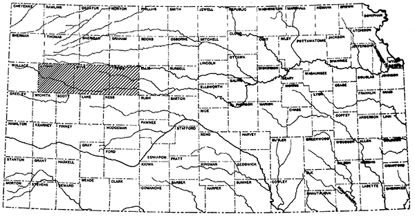
Trego, Gove, and Logan counties extend in a line from east to west across western Kansas between townships 11 and 15 S., inclusive and ranges 21 to 37 W., inclusive (Figure 1). This section of Kansas is in the High Plains physiographic province, but differs from,much of western Kansas in that erosion by Smoky Hill River and its tributaries has exposed, over about half the area of the counties, the Upper Cretaceous rocks which underlie the Tertiary capping of silt, sand and gravel. The topographic relief in this block of counties is greater than in any other part of western Kansas. The nearly flat High Plains cover a part of the northern half of Logan and Gove counties, and extend eastward across north-central Trego County between the valleys of Saline and Smoky Hill rivers. Except in southwestern Logan County, the northern edge of the High Plains south of Smoky Hill River lies for the most part beyond the southern boundary of the area covered in this report.
Figure 1--Index map of Kansas showing location of Logan, Gove, and Trego counties.
Smoky Hill River crosses Logan, Gove, and Trego counties from west to east, and its valley has an average width of about 15 miles. The break from the High Plains into the. valley is very abrupt, but between the foot of the cliffs and the river the slope is relatively gentle. Bad lands, formed through erosion of the soft upper Cretaceous rocks by running water, occur here and there along this slope.
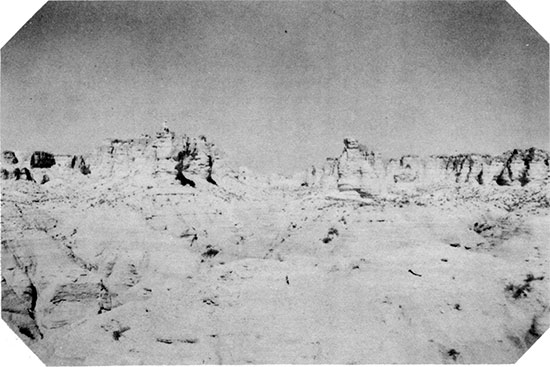
A picture of unusually well developed bad lands in the Cretaceous chalk of Logan County is given in Figure 2. This photograph was taken at the Chalk Bluffs locality, 5 miles west and a little over a mile north of Elkader, which is on Highway US 83, a short distance south of Smoky Hill River.
Figure 2--Bad lands, Chalk Bluffs, Logan County
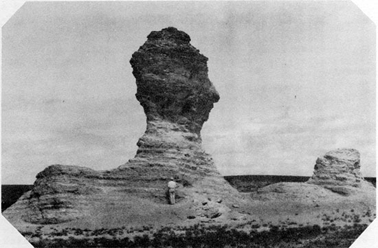
Rain wash, running water and wind have also carved the chalk beds into tall spires such as Castle Rock (Figure 3), and into such bizarre forms as Monument Rocks (Figure 4) and the Sphynx (Figure 5). Castle Rock is in eastern Gove County, and may be reached by following a county road 16 miles south from the west edge of Quinter, then going east 5 miles, north 1 mile, and thence northwest a short distance across the flats. The Monument Rocks and the Sphynx lie in a group in western Gove County, north of Smoky Hill River. They are accessible by turning off US 83 on a section line road 2 1/2 miles north of Smoky Hill River, driving 4 miles east, 2 miles south, 1 mile east, and one-half mile south.
Figure 3--Castle Rock, Gove County
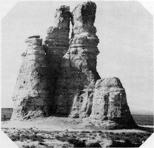
Figure 4--Monument Rocks, Gove County
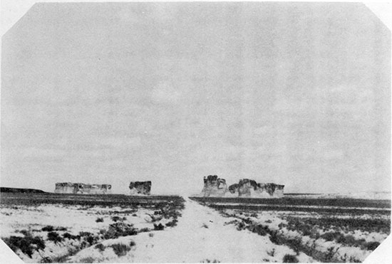
Figure 5--The Sphynx, Gove County
Northern Trego, Gove, and Logan counties are crossed from east to west by the Union Pacific Railroad and Highway US 40. The largest towns in the three counties, including Wakeeney, Quinter, Oakley, and Winona, are served by this railroad and highway. Gove, the county seat of Gove County, and Russell Springs, county seat of Logan County, are "inland" towns lying near the center of each county. One Federal Highway, US 83, crosses eastern Logan County from north to south, connecting with US 40 at Oakley. North-south state highways pass through Russell Springs, Gove, and central Trego County. County roads connect Russell Springs with Gove and Scott City, and a few other county roads cross parts of these counties. Section line roads are abundant on the High Plains, but road building has been impeded in Smoky Hill valley by the topography and by the expense of building permanent crossings across Smoky Hill River and its larger tributaries.
Grain crops are raised rin the High Plains, but in the valley the land, except locally, is devoted to grazing.
The purpose of this report is to outline the surface and subsurface geology of three adjacent western Kansas counties, and to compile records of drilled wells so that future exploration for oil and gas in this part of the state will be aided. It is hoped that the publication of this report will accelerate the development of western and northwestern Kansas.
Trego, Gove, and Logan counties have not been covered in detail in the reports hitherto published by the Kansas Geological Survey. An annotated list, arranged chronologically, of papers and bulletins in which some phases of the geology of this part of Kansas have been discussed follows:
1897, Haworth, E., and Logan, W. N., Report on Stratigraphy and General Geology of Western Kansas: University Geological Survey of Kansas, Vol. II. This report includes a general discussion of the physiography of western Kansas by Haworth and a stratigraphic discussion of the Upper Cretaceous by Logan.
1905, Darton, N. H., Preliminary Report on the Geology and Underground Water Resources of the Central Great Plains: U. S. Geological Survey, Professional Paper 32. Includes a chapter on the geology of central and western Kansas and records of deep water wells drilled in Logan, Gove, and Trego counties. [available online]
1917, Moore, Raymond C., and Haynes, Winthrop P., Oil and Gas Resources of Kansas: State Geological Survey of Kansas, Bulletin 3. A brief discussion is given of the surface geology for every county in Kansas.
1918, Darton, N. H., The Structure of Parts of the Central Great Plains: U. S. Geological Survey, Bulletin 691A. Included in this report is a structure map of the Dakota sandstone beneath the central Great Plains, including western Kansas. The contour interval is 100 feet. The elevations of the top of the Dakota sandstone were obtained mainly from water well records. [available online]
1922, Lupton, Charles G., Lee, Wallace, and Van Burgh, L. R., Oil Possibilities in Western Kansas: Bulletin, American Association of Petroleum Geologists, Vol. 6, pp. 69-90, March-April. The geology and subsurface information available at that time for western Kansas are described. Included are structure contour maps of several domes and closed anticlines mapped on the chalk beds of Logan and Gove counties.
1925, Bass, Nathan W., Geologic Structure of the Dakota sandstone in Western Kansas: Bulletin, American Association of Petroleum Geologists. Vol. 9, No. 6, pp. 1019-1023. Accompanying this report is a structure contour map of the Dakota sandstone drawn on all the well data available at that time and on outcrop elevations.
1926, Bass, N. W., Geologic Investigations in Western Kansas: State Geological Survey of Kansas, Bull. 11. Part 3 of this report is entitled "Geologic Structure of the Dakota Sandstone." The map included is similar to that published the year before. [available online]
1928, Pinkley, G. R., and Roth, R., An Altered Volcanic Ash from the Cretaceous of Western Kansas: Bulletin, American Association of Petroleum Geologists, Vol. 12, No. 10, pp. 1015-1022. An account of the presence and use made of thin layers of bentonite for structure mapping in the chalk exposures of Smoky Hill valley.
1929, Russell, Wm. L., Stratigraphy and Structure of the Smoky Hill Chalk in Western Kansas: Bulletin, American Association of Petroleum Geologists, Vol. 13, No.6, pp. 595-604. Includes a columnar section of the Smoky Hill chalk with its numerous bentonite streaks. Also discusses faulting in the Niobrara formation.
1931, Elias, Maxim K., The Geology of Wallace County, Kansas: State Geological Survey of Kansas, Bulletin 18. Wallace County lies immediately west of Logan County. This report includes the detailed stratigraphy of the Pierre shale, which overlies the Niobrara chalk formation and crops out extensively in western Logan County. [available online]
1932, Moss, Rycroft G., The Geology of Ness and Hodgeman counties, Kansas: State Geological Survey of Kansas, Bulletin 19. Ness County joins Trego County to the south. Much of the stratigraphic description given in this bulletin is applicable to Trego and Gove counties. [available online]
1935, Landes, Kenneth K., Scenic Kansas: State Geological Survey of Kansas. A popular description of the topographic features of the state, including Castle Rock, Monument Rocks, and the Sphynx, in Gove County, and the Chalk Bluffs or bad lands of Logan County.
1937, Landes, Kenneth K., Mineral Resources of Kansas Counties: State Geological Survey of Kansas, Mineral Resources Circular 6. This report includes brief descriptions of the developed and undeveloped mineral resources of. various counties in Kansas including Logan, Gove, and Trego. [available online]
1938, Ver Wiebe, Halter A., Oil and Gas Resources of Western Kansas, State Geological Survey of Kansas, Mineral Resources Circular 10. Discusses the subsurface stratigraphy, the history of oil and gas development, and the oil pools of Trego County.
The Introduction and the section on surface geology for this report were prepared by K. K. Landes, the balance, including the cross sections, by Raymond P. Keroher. Mr. Glenn Gordon assisted in the preparation of the cross sections.
The writers of this report are grateful to many of the oil geologists of Wichita for furnishing information and data, including well samples. Progress reports on the wells drilled in Trego, Gove, and Logan counties were obtained from the Oil and Gas Journal and the Oil Weekly.
Trego, Gove, and Logan counties belong in the High Plains province, the surface of which is covered with clay, silt, sand and gravel of the Ogallala formation, which was deposited during the Tertiary by eastward flowing rivers draining the Rocky Mountain area. Exposures of Pre-Tertiary rocks in this part of Kansas are due to erosion by Smoky Hill and Saline rivers and their tributaries. Smoky Hill river valley is cut through the Tertiary veneer, exposing the underlying rock across a belt of from two to three townships wide in the southern halves of Trego, Gove and Logan counties. Saline river valley crosses the extreme northern part of Trego County and likewise is cut through the Tertiary rocks.
Figure 6--Geologic map of Logan, Gove, and Trego counties
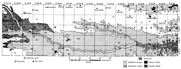
The Pre-Tertiary formations exposed are confined to the Upper Cretaceous in age. The upper part of the Carlile shale formation is found low in the valley of Smoky Hill River in southern Trego County, and is succeeded to the west by a complete section of the Niobrara formation and, in north central and western Logan County, by the lower part of the Pierre shale formation. The uplands are entirely covered by the Ogallala formation of Tertiary age. Relatively narrow deposits of Quaternary alluvium occur in the valley bottoms of Smoky Hill and Saline rivers and their major tributaries.
These formations, from oldest to youngest, are described briefly in the following paragraphs.
The name "Carlile" was originally applied by Gilbert to the shale series underlying the Niobrara formation in the vicinity of the town of Carlile, Pueblo County, Colorado [Gilbert, G. K., Underground waters of Arkansas Valley in Eastern Colorado, United States Geological Survey, 17th Annual Report, part 11, pp. 564-566, 1896]. Darton in 1904 first applied the term "Carlile" to strata of the same position in Kansas [Darton, N. H., Comparison of the stratigraphy of the Black Hills, Bighorn Mountains, and Rocky Mountain Front Range, Geological Society of America, Vol. 15, pp. 379-448, 1904]. However, before this time, in 1897, Logan applied the term Blue Hill shale to the noncalcareous shale occurring in the upper two-thirds of what is now called the Carlile formation [Logan, W. N., The Upper Cretaceous of Kansas, Kansas Geological Survey, Vol. II, pp. 215-221, 232-234, 1897]. Rubey and Bass in 1925 applied the term of Fairport in place og the Logan term, Ostrea, for the lower, calcareous part of the Carlile [Rubey, W. W., and Bass, N. W., The Geology of Russell County, Kansas, Kansas Geological Survey, Bulletin 10, pp. 44-47, 1925, available online]. Bass in 1926 named the Codell, a sandstone of variable thickness occurring at the top of the Carlile [Bass, N. W., The geology of Ellis and Hamilton counties, Kansas, Kansas Geological Survey, Bulletin 11, parts I and II, pp. 32-33, 66, 1926]. The terms Fairport, Blue Hill, and Codell are now used by the State Geological Survey of Kansas as names of members in the Carlile shale formation.
The Carlile shale outcrops from the junction of Hackberry Creek and Smoky Hill River eastward across southern Trego County to the Ellis County line. It is exposed between the flood plain of the river and the outcrop of the Niobrara formation on the sides of the valley. West of the mouth of Hackberry Creek it is buried beneath the Niobrara, and younger formations, so does not outcrop in Gove and Logan counties.
Only the upper part of the Blue Hill member, and the Codell sandstone member, outcrop in this area. The Blue Hill is predominantly a bluish black noncalcareous clay shale which weathers to a light bluish gray. It is very fissile, and fairly plastic when wet. Several zones of septarian concretions lie near the top, the highest about 40 feet below the base of the Niobrara formation. The concretions vary in size from that of an egg or hand grenade to spheres and spheroids as much as eight feet across. They are cut by numerous veins of brown calcite. Gypsum in characteristic diamond shaped crystals is abundant at a number of horizons in the upper Blue Hill shale.
The Codell sandstone is extremely variable in both thickness and character. In some places the entire section lying between the top septarian concretion zone and the base of the Niobrara formation consists of sandy shale and thin beds of sandstone. In other places the typical dark colored clay shale extends up to within a few feet, or even a few inches, of the base of the Niobrara, with yellowish or brownish sandstone beds above. The Codell consists of angular quartz grains and small bones. Where coarse and sufficiently thick, it is of local importance as a reservoir for underground water.
Measurements of the thickness of the Carlile shale in central Kansas show that it diminishes in thickness to the westward. A core hole drilled by Phillips Petroleum Company in Trego County, north of Ransom, logged 261 feet of this formation.
The Niobrara formation was named from Niobrara River in western Nebraska by Meek and Hayden in 1862 [Meek, F. B., and Hayden, F. V., Descriptions of new Lower Silurian, Jurassic, Cretaceous, and Tertiary fossils, collected in Nebraska, by the exploring expedition under the command of Lt. G. K. Warren, Philadelphia Academy of Science, Proc., Vol. 13, pp. 419-442, 1862]. The term Niobrara has been applied practically ever since to western Kansas strata lying below the Pierre shale formation and, in the early days, extending as far down the column as the top of the Dakota, including the Graneros, Greenhorn, and Carlile of present usage. Williston restricted the Niobrara formation to its present range in 1892 [Williston, S. W., The Niobrara Cretaceous of Western Kansas, Kansas Academy of Science, Transactions, Vol. VIII, pp. 107-111, 1892]. The early geologists of Kansas applied several member names within the Niobrara formation, including the Fort Hays, Osborne limestone, Pteranodon beds, Smoky Hill chalk, and the Colorado terms, Apishapa and Timpas. Williston in 1896 further subdivided the Pteranodon beds into the Hesperornis and Rudistes beds, and Cragin split the Smoky Hill into the Graham Jasper, Norton zone, and Trego zone [Williston, S. W., Smoky Hill Chalk, Kansas University Quarterly, Vol. 4, pp. 251-252, 1896; Cragin, F. W., On the stratigraphy of the Platte series, or upper Cretaceous of the Plains, Colorado Coll. studies, Vol. 6. pp. 50-52, 1896]. Of these various member names, those which survived and are incorporated in present usage are the Smoky Hill chalk member (upper) and the Fort Hays limestone (lower). The Smoky Hill chalk includes the Apishapa and upper Timpas of the Colorado nomenclature and the Fort Hays limestone correlates with the lower Timpas.
The Niobrara formation is exposed in a belt 12 to 20 miles wide in Smoky Hill valley across the southern halves of Trego, Gove and Logan counties. It is also exposed in east central Trego County in the valley of Big Creek and along the north edge of the same county in Saline River valley. The outcrop is widest in central Gove County at the junction of the valleys of Hackberry Creek and Smoky Hill River.
The Niobrara is notable for its effect on topography. The soil cover is either thin or absent, vegetation is scanty, and, in consequence, rain wash and stream cutting have produced bad lands in many places. The forces of erosion also have isolated bodies of chalky shale in the Upper Niobrara and carved from them rock spires (Castle rock, Monument rocks), and fantastic forms such as the Sphynx.
The base of the Niobrara formation is present near the bottom of Smoky Hill valley in Trego County and the top is exposed in 'central and western Logan County beneath the overlying Pierre shale. The total thickness of the formation is between 700 and 800 feet. Of this amount, the lowermost 70 to 80 feet is the Fort Hays member, and the balance is Smoky Hill.
The Niobrara formation consists almost entirely of alternating beds of chalk and chalky shale. No sand and no noncalcareous shale are present. Many thin seams of bentonite occur; especially in the Smoky Hill member, and thin veins of limonite and gypsum are also present, but less abundant. Iron sulphide (pyrite) concretions are scattered along the bedding planes at a few horizons.
The lower, or Fort Hays, member is distinguished from the Smoky Hill member by the relative predominance of massive beds of chalky limestone. These beds range from three to six feet in thickness and are separated by one to three inch partings of chalky shale. The chalk is grayish white, but may be stained yellow or brown at the outcrop. The beds of chalk in the Fort Hays member are cliff makers. A short distance northwest of the mouth of Hackberry Creek, this limestone makes a high cliff where the following section was measured:
| Fort Hays section, NW 25-14-25 (Mouth of Hackberry Creek) | Feet |
|---|---|
| Bentonite (Base of Smoky Hill member) |
.05 |
| Soft chalk and chalky shale |
5.5 |
| Chalk | 1.6 |
| Chalky shale parting | |
| Chalk | 0.2 |
| Chalky shale | 0.1 |
| Chalk | 0.7 |
| Chalky shale | 0.8 |
| Chalk | 1.5 |
| Chalky Shale parting | 0.1 |
| Chalk | 2.6 |
| Chalky shale | .05 |
| Chalk | 1.3 |
| Chalky shale parting | |
| Chalk | 3.4 |
| Chalky shale | 0.5 |
| Chalk | 0.4 |
| Chalky shale parting | |
| Chalk | 2.4 |
| Chalky shale | 0.2 |
| Chalk | 1.1 |
| Chalky shale | 0.5 |
| Chalk | 1.0 |
| Chalky shale | 0.3 |
| Chalk | 0.4 |
| Chalky shale parting | |
| Chalk | 1.9 |
| Chalky shale | 0.6 |
| Chalk | 0.6 |
| Chalky shale | 0.4 |
| Chalk | 1.6 |
| Chalky shale parting | |
| Chalk | 1.9 |
| Chalk and chalky shale | 0.7 |
| Cbalk | 1.9 |
| Chalky shale | 0.2 |
| Chalk | 1.7 |
| Chalky shale | 0.3 |
| Chalk | 2.1 |
| Chalky shale | 1.2 |
| Chalky shale | .15 |
| Chalk | 0.9 |
| Chalky shale | 0.2 |
| Chalk | 2.8 |
| Chalky shale and shale | 1.0 |
| Chalk | 0.5 |
| Chalky shale parting | |
| Chalk | 2.8 |
| Chalky shale | 0.5 |
| Chalk | 1.6 |
| Chalky shale | 0.3 |
| Chalk | 3.3 |
| Chalky shale | 0.1 |
| Chalk | 3.9 |
| Chalky shale | 0.2 |
| Chalk | 5.1 |
| Chalky shale parting | |
| Chalk | 4.6 |
| Chalky shale parting | |
| Chalk | 4.1 |
| Chalky shale parting | 0.1 |
| Chalk | 1.8 |
| Chalky shale parting | |
| Chalk (Base of Fort Hays member and Niobrara formation) |
1.7 |
| Top of Blue Hill shale member and Carlile formation (Codell sandstone absent) |
The top of the Fort Hays member is arbitrarily considered to be a pair of bentonitic seams. Lithologically, the top is several feet below at the top of the uppermost thick chalk bed. Because this horizon is not readily recognizable in all exposures the pair of bentonites above has been chosen to mart the boundary between the Fort Hays and Smoky Hill members.
The Fort Hays member is buried beneath Smoky Hill chalk and younger rocks west of eastern Gove County. It is exposed near the bottom of Smoky Hill valley across southern Trego County, and in the valleys of Big Creek and Saline River in the east central and northern parts of Trego County.
The Smoky Hill member consists of alternating thin beds of chalk and chalky shale. Both the chalk and the chalky shale beds are of approximately the same thickness. Because of the lesser resistance to erosion of the chalky shale, exposures of Smoky Hill rocks tend to become 'fluted'. Bentonite and limonite seams are much more abundant in the Smoky Hill member than in the Fort Hays. These layers are replaced by gypsum in some places. Pyrite concretions are fairly abundant at certain horizons in the Smoky Hill member. Where such concretions have been exposed for any appreciable length of time, they have altered to hydrous iron oxide (limonite) producing a discoidal yellow "pie".
Both the chalks and chalky shale are blue where unweathered and differ little in appearance. Any chalk bed of sufficient porosity may be replaced by chert where overlain by Tertiary rocks, due to ground water precipitation of silica dissolved from the Ogallala formation.
The Smoky Hill member may be divided into three general divisions. The lower division contains chalk which weathers to yellow or buff color. The A to F beds of Moss in Ness County belong here [Moss, Rycroft G., The Geology of Ness and Hodgeman counties; Kansas, Kansas Geological Survey, Bulletin 19, 1932, available online]. The middle division consists of gray and white chalk, but the chalk beds in the upper group weather to orange, brown, or red.
The chalk beds in the lower division make bad lands of moderate relief. No thick cliff making series of beds is present. Exposures of this group are confined to the Smoky Hill valley in western Trego and eastern Gove counties.
The middle division of the Smoky Hill member is the least colorful because not enough iron is present to produce bright colors upon exposure. This group is also known as the Castle Rock series because the monolith in eastern Gove County is carved from these beds. Other prominent topographic features formed from the same group of rocks are Monument rocks, Chalk Bluffs (west of Elkader), Hell Creek bad lands, the Ben Allen outliers in the southeastern part of section 11 and the northeastern part of section 14, T. 15 S., R. 33 W., and small buttes out beyond the foot of Eagle Buttes in southwestern Logan County. The strata belonging to the middle division crop out in Smoky Hill valley between western Logan County and eastern Gove County.
The upper division of the Smoky Hill member is the reddest of the three divisions. It erodes into bad lands of considerable relief and gaudy colors. This group contains a series of cliff making strata, which is in some places cut by canyons with overhanging nails. The cliffs and canyons are inhabited by eagles, owls, and rattlesnakes. Eagle Buttes in southwestern Logan County are built of chalk and chalky shale beds belonging in the upper group.
The shales in the upper division are highly gypsiferous, and are cut by a multitude of ramifying gypsum veins, especially toward the base of the series. These veins are no thicker than a sheet of paper in most instances, but the gypsum seams replacing bentonite, and those occurring along fault planes, are much thicker. The upper division of the Smoky Hill member outcrops high in the valley in western Gove County and all the way across Logan County.
The Niobrara rocks of Smoky Hill valley have long been a "happy hunting ground" for fossil collectors. Many interesting extinct animals, beside the minute chalk-forming organisms, lived in the sea and on the nearby land at the time these rocks nere deposited. The most bizarre of the animals nere the reptiles, most of which swam in the seas, although bird-like varieties that could fly were also present. Among the aquatic reptiles were the plesiosaurs, about half of whose great length was neck, and the mosasaur, a huge carnivorous lizard about 35 feet long. Fossil remains of several mosasaurs, including the Tylosaurus, Platacarpus, and Clidastes have been found in western Kansas [Partial fauna list of Niobrara compiled by J. Mark Jewett]. In addition to the flying reptiles, some of which were very large, were true birds, but unlike modern birds they possessed teeth. Examples are the Hesperornis regalis, Hesperornis crassipes, Ichthyornis agilis, and Ichthyornis dispar. Skeletons of many genera and species of fish have een found in the chalk beds, including sharks and teleosts. Among the latter is the great Portheus, which reached a length of 15 feet. Vertebrate remains from the rocks of Gove and Logan counties are displayed in museums throughout the world.
The Niobrara chalk and chalky shale beds also contain an abundant invertebrate fauna. The chalk itself is composed of minute shells of foraminifera belonging mainly to the families Globigerinidae and Textularidae. Larger invertebrates belong mainly to the Echinoderma and Mollusca. An example of the former is Uintacrinus socialis, which has been found abundantly strewn through large slabs of rock. The most numerous forms in the Niobrara, however, are the Mollusca Inoceramus platinus and Ostrea congesta, The latter commonly occurs attached to large Inoceramus shells. Several other species of Inoceramus and Ostrea, including Ostrea larva have been found in these rocks.
The Pierre shale was not studied in detail in the preparation of this report as it has been studied and described by Elias in a bulletin on Wallace County which includes the Pierre shale exposures in Logan County [Elias, Maxim K., The Geology of Wallace County, Kansas, Kansas Geological Survey, Bulletin 18, 1931, available online]. This formation consists of dark gray to black, laminated, unctuous shale. It weathers to lighter shades.
The Pierre shale lies at the surface in north central and western Logan County, and covers a wide area to the west in Wallace County. The entire section of this formation in Smoky Hill valley measures about 600 feet, but this is only the lower half of the Pierre as exposed farther west in Colorado.
The Pierre in Logan County includes no more than the lower-most 155 feet of the formation, and belongs to the Sharon Springs member of the Elias classification. This member has been split into two divisions, lower and upper. The lower division, which is 90 feet thick, consists of "flaky, somewhat bituminous black shale with abundant small fish bones and scales." Concretions are almost entirely absent. The upper division of the Sharon Springs member, about 65 feet in thickness, is lithologically similar, but contains zones of large septarian concretions which form the McAllaster Buttes, one mile east of the station of MeAl laster, and other prominent hills to the north of the station. These concretions are cut by veins of calcite, and, more rarely, barite. They are similar in appearance to the concretions occurring in the upper part of the Blue Hill member of the Carlile formation. Smaller limestone concretions are also present.
The Tertiary rocks of western Kansas are confined to the Ogallala formation of late Miocene and Pliocene age. Elias describes these rocks in detail as they occur in Wallace County, immediately to the west of Logan County [Elias, Maxim K., The Geology of Wallace County, Kansas: Kansas Geological Survey, Bulletin 18, 1931, available online]. They consist of clay, silt and sand which were irregularly distributed over the Great Plains by eastward flowing streams which had their sources in the Rocky Mountains. Subsequently some of the more porous layers, such as beds of sand, have been closely cemented by the precipitation of calcium carbonate from ground waters. These hard and gritty strata are locally known as "mortar beds". They resist erosion to a far greater extent than the associated unconsolidated materials, and in consequence tend to form canyons walls and prominent benches where undergoing erosion. An unusually good exposure of the Ogallala formation, including several "mortar beds," can be seen in the valley of Ladder or Deaver Creek in Scott County State Park, a short distance south of the Logan County line.
The Ogallala formation caps the uplands across north central Trego County, northern Gove County, and northern and southwestern Logan County. Where not cut into by stream valleys, the Ogallala surface is notably flat. The more porous layers in this formation are important carriers of ground water and are exploited throughout the upland area for farm and municipal use.
Where not partially eroded away, the Ogallala formation has a thickness of about 200 feet.
Coarse gravel overlies the Ogallala formation in many places in western Kansas. Some of this gravel is composed of igneous and metamorphic rocks which were obviously carried into Kansas by post-Ogallala streams draining the Rocky Mountains. In Trego, Gove and Logan counties, the gravel is very irregularly distributed and very thin.
The loess of western Kansas has been named the Sanborn formation by Elias [Elias, Maxim K., The Geology of Wallace County, Kansas, Kansas Geological Survey, Bulletin 18, 1931, available online]. It caps the stream divides and has a maximum thickness of about 60 feet. The Sanborn loess consists of yellowish-buff fine silt. It is not stratified, and has the characteristic ability of loess to stand with a vertical face where cut into by erosion or by human activity. The Sanborn formation has been classified as Pleistocene in age.
Southwestern winds during Pleistocene times blew volcanic ash, probably from northeastern New Mexico volcanos, over Kansas. Some drifts of this ash were blown into protected places and have been preserved to the present. One such deposit in east central Gove County and another in eastern Logan County north of Smoky Hill River are described in a bulletin of the State Geological Survey of Kansas [Landes, Kenneth K., Volcanic Ash Resources of Kansas, Kansas Geological Survey, Bulletin 14, 1928]. Other deposits have been found in Trego and Logan counties since the publication of this report. Mr. Hudson Harlan (letter dated May 27, 1931) reports two deposits in Trego County, one near the east line of the county on the north bank of Smoky Hill River in secs. 33 or 34, T. 14 S., R. 21 W. The other also lies on the north side of the river, in sec. 35, T. 14 S., R. 23 W. Hitherto undescribed deposits in Logan County have been found near the northeast corner of sec. 111 T. 13 S., R. 35 W. The ash occurs on both sides of a small valley and is about nine feet thick with an overburden of ten feet. Mr. W. T. Bishop of Winona (letter dated March 14. 1932) has reported the discovery of still another Logan County deposit, one which is apparently of large size and unusual thickness.
The streams traversing Trego, Gove, and Logan counties have deposited sand, silt, and gravel in relatively narrow flood plains. These materials were derived from the Sanborn loess, Quaternary gravel, Ogallala formation, and Upper Cretaceous rocks. Chalk pebbles are especially abundant along the flood plain of Smoky Hill River.
The Cretaceous formations across Trego, Gove, and Logan counties have a gentle dip to the north, according to the map published by Bass [Bass, N. W., Geologic structure of the Dakota sandstone of western Kansas, Kansas Geological Survey, Bull. 11, part 3, p. 95, 1926]. This regional dip is interrupted in many places by folds and faults. Lupton, Lee, and Van Burgh describe sixteen surface anticlines, most of them in the area of Niobrara outcrop in the southern half of Logan County and in southwestern Gove County [Lupton, Charles T., Lee, Wallace, and Van Burgh, L. R., Oil Possibilities of Western Kansas, Bulletin American Association of Petroleum Geologists, Vol. 6, pp. 69-90, 1922]. Contour maps are included in this report for the Twin Buttes anticline, which has its highest point in the southwest corner of T. 14 S., R. 36 W., the Chalk Creek dome in secs. 35 and 36, T. 15 S., R. 34 W., and extending southward into Scott County, the Elkader dome with its highest points in secs. 15 and 22, T. 14 S., R. 32 W., the Hell Creek structure, mainly in the southwestern corner of Gove County, but extending westward into Logan County and southward into Scott County, and Alanthus dome, lying mainly in the northeastern corner of T. 15 S., R. 27 N., but extending northward, northeastward, and eastward into the three adjoining townships. One of these anticlines, the Hell Creek, has a closure as mapped from surface dips of about 150 feet, and a total structural relief of over 200 feet. Experience has shown, however, that the local dips in the chalk are not very reliable criteria of true structural conditions. In fact, Russell has observed that some of the structures as mapped on local dips have been found to be imaginary when checked with a core drill [Russell, W. L., Stratigraphy and structure of the Smoky Hill chalk in western Kansas, Bulletin American Association of Petroleum Geologists, Vol. 13, No. 6, pp. 595-604, 1929].
Some of the relatively steep dips in the chalk beds are obviously due to slumping of very large blocks in the Niobrara. Dips of this character up to 20° have been measured.
Many small faults and a few faults with large displacements, have been found in the chalk beds and overlying Pierre shale in the valley of Smoky Hill River. One graben type of fault, which has dropped a block of Pierre shale down into the Niobrara near the middle of T. 14 S., R. 31 W., is shown on the geologic map of Kansas. Another fault with considerable displacement is shown in T. 15 S., R. 32 W. This fault has brought up chalk belonging to the middle or Castle Rock division of the Smoky Hill member so that it underlies the Ogallala, on the west side of Beaver or Ladder Creek valley, while the upper division, containing the brightly colored Eagle Butte series of chalk beds, with an overlying thin section of lower Pierre shale, is exposed on the east side of the valley. Another and parallel fault to the east puts Pierre shale against Eagle Butte chalk. These faults are definitely post-Pierre and pre-Ogallala in age.
A fine example of a fault line scarp can be seen along a part of Beaver Creek fault. The fault lines can also be traced by means of many selenite gypsum crystals at the outcrop.
Russell has suggested that the faulting was produced by adjustment of the brittle chalk to deformation in the underlying rocks [Russell, W. L., Stratigraphy and structure of the Smoky Hill chalk in western Kansas, Bulletin American Association of Petroleum Geologists, Vol. 13, No. 6, pp. 595-604, 1929]. It is quite possible that the small, highly faulted areas are due to sinking into large caves dissolved in deeper, soluble rocks such as those in the Fort Hays member. The large faults, however; must have a different explanation. Perhaps this area lies within the region affected by the Laramide Revolution, which was most intense in the Cordilleran belt at the close of the Mesozoic.
Bentonite zones are extremely important key horizons for detailed structure mapping, and for correlating strata within the Niobrara. Some of the beds, especially in the Fort Hays member, can be traced by thickness and position in the succession.
Logan, Gove, and Trego counties lie along the western flank of a broad buried arch, the central Kansas uplift, and along the northern edge of the Dodge City basin, which is an extension of the Anadarko Basin of Oklahoma. Due to this position with respect to these major subsurface geological features of western Kansas the three counties may be considered as a single unit in discussing their subsurface conditions.
According to recent investigations [Morgan, L. C., Central Kansas uplift, American Assoc. Petroleum Geologists, Bull., vol. 16, pp. 483, 484, 1932; Koester, Edward A., Geology of central Kansas uplift, American Assoc. Petroleum Geologists, Bull., vol. 19, pp. 1405-1428, 1935] the central Kansas uplift is a repeatedly "rejuvenated structural feature trending northwest and southeast across west-central Kansas.... It originated in pre-Cambrian time as a series of parallel batholiths and persisted as a positive element throughout much of Paleozoic time. Several periods of broad warping and erosion occurred during the Paleozoic and Mesozoic eras." [Koester, Edward A., Geology of central Kansas uplift, American Assoc. Petroleum Geologists, Bull., vol. 19, pp. 1405, 1935] The axis of the uplift extends diagonally across Barton and Ellis counties in a northwest direction. The counties which are high on the uplift are southwestern Russell, all of Ellis, all of Rush except the southwest quarter, northeast Pawnee, and northeast Trego.
Within the central area of the uplift are two northwest-southeast trending structural "highs" or "ribs" situated above correspondingly high areas in the basement rock. These have been named the Russell "rib" and the Rush "rib". The Rush "rib" extends in a northwest direction across the eastern parts of Rush and Trego counties [Landes, Kenneth K., and Keroher, Raymond P., Geology and oil and gas resources of Rush County. Kansas Geological Survey, Mineral Resources Circular 4, 1938, available online].
Due to the westward dip away from the central Kansas uplift, and to the increasing elevation of the land surface, the depth to the underlying formations increases rather rapidly westward across the three counties. The shallowest known depth of granite is southwest of Wakeeney, where it was encountered at 4,258 feet in the Mid-Kansas well No. 1 Ridgeway in sec. 28, T. 12, R. 21 W. In western Logan County, 70 miles westward, granite was encountered at a.depth of 5,665 feet in the Alma-McNeely No. 1 Watchorn, sec. 13, T. 15, R. 33 W.
Data from drill cuttings form the chief basis for the following discussion. However, where drill cuttings were not available or were incomplete, it was necessary to supplement this information with drillers' logs.
The subsurface units are c~~elated with the divisions recognized by Betty Kellett [Geologic cross-section from western Missouri to western Kansas, Kansas Geological Society, Guidebook, Sixth Annual Field Conference, 1932.] In most cases the minor subdivisions are not recognizable over the entire area; however, there are a number of beds or zones which may be correlated accurately over long distances. These correlation points are recognized and used by oil geologists when running samples. A few zones are sufficiently outstanding in character that they can be recognized and logged by drillers, which makes possible the use of drillers' logs in correlating some formations.
A fair degree of accuracy in correlating minor divisions can be obtained by reference to higher or lower beds that can be accurately correlated. Even by this method it is almost impossible to recognize with certainty many of the small units. It is therefore preferable in this discussion to consider as units those rocks which are separated by fairly persistent marker beds. These units are defined by the tops or bottoms of the recognizable beds in the accompanying geological sections across Logan, Gove, and Trego counties.
A relatively thin mantle of Tertiary and Pleistocene rocks overlies the deeply eroded surface of Cretaceous rocks throughout the greater part of the area of the three counties. The maximum thickness of 260 feet occurs where considerable valley fill is present. In other places erosion has removed all of the younger rocks, leaving the Cretaceous rocks exposed at the surface.
The Post-Cretaceous rocks consist of unconsolidated sands, shale, and clay. These formations have been discussed in the section dealing with the areal geology of the three counties. No attempt has been made to differentiate the Post-Cretaceous rocks, due to the absence of samples and the difficulty in differentiating such material by means of drillers' logs.
The depth to the top of the Cretaceous in Logan, Gove, and Trego counties varies from zero over a large part of the three counties to some 260 feet in western Logan County. The total thickness of Cretaceous rocks varies from 600 feet in eastern Trego County to 1,600 feet in western Logan County. This greatly increased thickness is due to the westward dip of the Cretaceous rocks, the increasing elevations of the land surface westward, and a divergence of the Cretaceous formations. For the same reason, the age of the Cretaceous rocks become progressively younger in going westward from Trego to Logan County. For the purpose of this discussion three major subdivisions of the Cretaceous rocks are recognized in the three counties. They are, in descending order, the Montana group, the Colorado group, and the Dakota group.
The Pierre shale, which is the basal formation of the Montana group in this area, is present in parts of Logan and Gove counties. This formation has been described in the section devoted to the areal geology of the three counties.
The total thickness of rocks comprising the Colorado group varies from approximately 200 feet in eastern Trego County to about 1,000 feet in. western Logan County, where a complete section is present. This variation in thickness is mainly due to the erosion of the younger Colorado rocks in the eastern part of Trego County. The truncated surface of the Colorado group is overlain by Pierre shale. Four major subdivisions of the Colorado group are recognized. These are, in descending order: the Niobrara chalk, Carlile shale, Greenhorn limestone, and the Graneros shale.
The Niobrara formation has been removed by erosion over a considerable part of the three counties. The uppermost member of the Niobrara formation is the Smoky Hill chalk which has a maximum thickness, approximately 550 feet, in the Morgan-Flynn and Cobb McMillen No. 1 well in sec. 9, T. 13 S., R. 37 W. It consists of chalky shale which varies in color from dark to light gray. Inoceramus shells are common.
The Fort Hays member of the Niobrara varies in thickness from 40 to 65 feet. It is composed dominantly of white to cream-colored chalk. Inoceramus shells and species of Globigerina are common. The base of the Fort Hays limestone is abrupt, as it is underlain by the Carlile shale.
The Carlile shale varies in thickness from 150 to about 260 feet. Three members of the Carlile shale are recognizable in a few wells. They are, in descending order, the Codell sandstone, the Blue Hill shale, and the Fairport shale.
The Codell sandstone is recognizable only in a few wells where a fine-grained argillaceous sandstone immediately underlies the Fort Hays limestone. Due to its thinness and argillaceous composition, the Codell cannot be distinguished with any degree of certainty in drillers' logs.
The Blue Hill shale varies in thickness from 115 to 190 feet. It consists of dark gray non-calcareous shale throughout most of its thickness, although some parts are calcareous enough to effervesce slightly in acid. Although not notably fossiliferous, Inoceramus shells are common.
The Fairport shale, which immediately underlies the Blue Hill shale, reaches a maximum thickness of approximately 100 feet. It is a dark gray to tan calcareous shale containing an abundance of Inoceramus shells. The Fairport shale is underlain by the Greenhorn formation.
The Greenhorn formation occurs over most of the area of Logan, Gove, and Trego counties and is approximately 100 feet thick. In exceptional cases the four members of the Greenhorn, the Pfeifer shale, Jetmore chalk, Hartland shale, and Lincoln limestone can be recognized. The Pfeifer shale is distinguishable from the overlying Carlile shale (the Fairport) only where the uppermost limestone, the "Fencepost," can be identified.
The Jetmore limestone which under lies the Pfeifer shale is composed of gray-brown chalk at the top and harder light-gray chalk or limestone at the base. This member contains an abundance of Inoceramus shells and Globigerina. The Hartland shale underlying the Jetmore limestone is a dark to light gray argillaceous shale. The Lincoln limestone, the lowermost member of the Greenhorn formation, is a dark gray to tan crystalline limestone, interbedded with gray to cream-colored chalk. This member immediately overlies the Graneros formation.
The Graneros formation is the basal formation of the Colorado group. It varies in thickness from 50 to 90 feet, with its maximum development in the western part of Logan County. The Graneros consists of dark gray argillaceous shale with a considerable amount of fine gray, tightly-cemented sand. It overlies the Dakota group throughout the entire area of Logan, Gove, and Trego counties.
All of Logan, Gove, and Trego counties is underlain by rocks of the Dakota group. The thickness of these formations varies from 450 to 550 feet. No attempt will be made here to differentiate the various members of the Dakota which have been recognized at the outcrop. Throughout its entire thickness the rocks comprising this group are predominantly sandstone, interbedded with brown to reddish shale, and some limestone. The sand consists of fine to coarse grains of quartz which are sub-angular to angular in shape. A fairly persistent zone of yellow to pink or tan siderite occurs near the top.
A widespread unconformity occurs at the top of the Permian rocks in Logan, Gove, and Trego counties. Due to the westward dip of the Permian beds and the increasing elevation in land surface, the depth to the top of the Permian varies considerably in the three counties. The minimum depth of 880 feet noted was in the Olson Drilling Company No. 1 Lang well in sec. 1, T. 14 S., R. 21 W. The depth increases westward to the maximum observed depth of 1,878 feet in the Morgan Flynn and Cobb No. 1 McMillan in sec. 9, T. 13 S., R. 37 W., in western Logan County.
The two major divisions of the Permian, the upper Cimarron series and lower Big Blue series, are readily recognized both from samples and drillers' logs.
The total thickness of the Permian rocks varies from 1,850 feet in the Johnson-Atlantic No. 1 Wright well, sec. 11, T. 12 S., R. 27 W., to a maximum of 2,100 feet in the Thurman-Hill et al. No. 1 Lawson in sec. 7, T. 14 S., R. 22 W. The average thickness is 2,000 feet.
Due in part to the deeply eroded surface of the Permian, the Cimarron rocks vary considerably in thickness throughout the three counties. A minimum thickness of 720 feet was observed in the Morgan, Flynn and Cobb No. 1 McMillan well in sec. 9, T. 13 S., R. 37 W. The greatest observed thickness was 1,120 feet in the Marathon Oil and Gas Company No. 1 Kline well in sec. 19, T. 14 S., R. 24 W. The average thickness throughout the three counties is 900 feet. Based on lithological characters, three divisions of the Cimarron series are readily recognizable.
The upper part of the Cimarron series is defined by the unconformity which marks the top of the Permian system, and at the base lies the Stone Corral member. This part varies in thickness from 540 feet in the Morgan, Flynn and Cobb No. 1 McMillan well, sec. 9, T. 13 S., R. 37 W., to 860 feet in the Marathon Oil and Gas Company No. 1 Kline, in sec. 19, T. 14 S., R. 24 W. The average thickness is 750 feet. It consists dominantly of thick shales and sandstones with a few thin beds of dolomite and anhydrite. The sand and shale are all red in color, varying from light pink to deep maroon. The sand grains are dominantly quartz, subangular to rounded in shape. The finer texture and red color of the cementing materials differentiate the Permian sands from the overlying Morrison and Dakota sands.
Most commercial geologists make no attempt to subdivide the Upper Cimarron; consequently the samples from this interval are not taken with sufficient care to permit exact determination of the tops of the different beds. However, comparison of the stratigraphic position and lithological characters of subsurface units in one well with corresponding units in other wells, and with the surface outcrop, indicates that most of the beds are continuous throughout Logan, Gove, and Trego counties.
A thin dolomite near the top of the Cimarron is tentatively correlated with the Day Creek dolomite. A thick section of sandstone and shale varying in thickness from 200 to 400 feet underlies the Day Creek dolomite and correlates with the undifferentiated Whitehorse sandstone and Dog Creek shale.
The Stone Corral member of the Cimarron varies in thickness from a minimum of 20 feet in the Jenmar No. 1 Jones well in sec. 20, T. 12 S., R. 23 W., in Trego County, to a maximum of about 100 feet in the Taylor No. 1 Allman well in sec. 34, T. 14 S., R. 21 W. The average thickness is about 50 feet. This member consists of light to dark gray anhydrite. In some wells it is underlain by dolomite.
Due to its easily recognizable character and its persistence over a considerable area, the Stone Corral is much used by drillers and geologists as one of their correlation points during drilling. It is easily recognizable in nearly all logs, but in badly kept drillers' logs it may be confused with the higher anhydrite beds in the Cave Creek formation.
The lower Cimarron consists of about 200 feet of red shale, red sandstone, and in some wells considerable anhydrite. The minimum thickness of 20 feet was noted in the Taylor No. 1 Allman well in sec. 34, T. 14 S., R. 21 W. The maximum thickness was in the Kline No. 1, in sec. 19, T. 14 S., R. 24 W. The lower Cimarron is defined at the base by the unconformity which marks the top of the Big Blue series.
The thickness of the Big Blue series varies from a minimum of 910 feet in the Alma-McNeeley No. 1 Watchorn well in sec. 13, T. 15 5., R. 33 W., to a maximum of 1,230 feet in the York state No. 1 Gugler well, sec. 36, T. 12 5., R. 21 W. The Big Blue series contains at the top the relatively shaly Wellington formation. The bottom is the less easily recognized shale at the base of the Admire group.
The Wellington formation varies from a thickness of 290 feet in the Alma-McNeeley No. 1 Watchorn well in section 13, T. 15 5., R. 33 W. to 560 feet in the York state No. 1 Gugler in sec. 36, T. 12 5., R. 21 W. The average thickness is 350 feet. The Gueda salt separates the red and gray shales and anhydrite in the upper Wellington from those in the lower part.
The maximum thickness of the Gueda salt noted in wells in Logan, Gove, and Trego counties was 210 feet in the No. 1 Gugler well, sec. 36, T. 12 S., R. 21 W. It is very difficult to obtain an accurate measurement of the salt thickness, because samples are lost by solution during drilling.
The lower part of the Big Blue series consists of dolomites and limestones alternating with layers of red, green, and black shale. The rock in this section of the Big Blue forms the lower part of the Sumner group and all of the Council Grove and Admire groups of the State Geological Survey classification} however, most of the characteristics upon which surface classification is based are not recognizable in subsurface studies. There are, however, a number of zones or horizons which are consistently recognizable over large areas and are commonly used by geologists in correlating subsurface units in connection with petroleum development. These zones are in descending order: top of the Herington, base of the Winfield, top of the Fort Riley, base of the Florence, base of the Wreford, top of the Neva, and the base, of the Americus. In this discussion, all of the formations in the interval between two recognizable horizons will be considered as a unit.
The Herington limestone is the first zone below the Wellington that can be consistently identified. It is recognizable because of its position immediately below the Pearl shale, which, due to its thickness and characteristic color, forms a distinct break between the overlying thin dolomite of the Donegal formation and the underlying Nolans formation with the Herington limestone at the top.
The base of the Winfield formation is defined by the underlying thick and red Gage shale. The formations in the interval between the top of the Herington and the Winfield are the Nolans limestone (or dolomite) and the Odell shale.
The Fort Riley marks the base of a relatively thick shaly section which is composed of the light gray to red Gage shale at the top and the red Holmesville shale at the base. These two shales are separated by the thin Towanda limestone which is not recognizable in most samples.
The Barneston formation, with the Fort Riley at the top and the cherty Florence limestone at the base, consists dominantly of limestone or dolomite with the thin, gray Oketo shale near the top. The Florence limestone can be identified by the presence of large amounts of gray chert and its position above the Blue Springs shale, which is a relatively thick red to green argillaceous shale.
The base of the Wreford formation marks the base of a relatively shaly section about 95 feet in thickness which is composed of, in descending order, the red and green Blue Springs shale, the Kinney limestone, the red, gray, and green Wymore shale, the Schroyer limestone, the light gray Havensville shale, and the Threemile limestone at the base. The base of the Wreford is the boundary between the Chase group and the underlying Council Grove group.
The Neva limestone is recognized by its position at the base of the thick red and green Eskridge shale. The rocks between the base of the Wreford and the top of the Neva comprise the red, gray, and green Speiser shale, the Bigelow limestone formation, the Easley Creek shale, the Bader limestone, the Stearns shale,the Beattie limestone, and the Eskridge shale.
The next easily identifiable horizon is the base of the Americus limestone. It is recognizable because of the large number of fusulinids commonly present and its position below the thick shales in the Foraker formation. The formations between the top of the Neva and the base of the Americus are, in descending order: the Grenola formation, of which the Neva limestone is the top member, the red, gray, and green Roca shale, the Red Eagle formation, the Johnson shale, and the Foraker formation with the Americus limestone at the base.
The shaly Admire group which lies at the base of the Permian in Kansas consists of the red, green, and gray Hamlin shale at the top, the thin Fivepoint limestone, the West Branch shale, the thin Fall City limestone, the Hawxby shale, the Aspinwall limestone, and the Towle shale. The unconformity at the base of the Indian Cave sandstone member of the Towle shale marks the top of the Pennsylvanian system of Kansas. This unconformity is almost never logged in exploration for oil, either by drillers or geologists.
Rocks of Pennsylvanian age underlie the entire area of Logan, Gove, and Trego counties at a depth varying from 2,880 feet to 3,630 feet. The minimum depth found was in the Black Gold No. 1 Taylor-Allman well in sec. 34, T. 14 5., R. 21 W. The maximum depth was in the Morgan-Flynn and Cobb No. 1 McMillen, sec. 9, T. 13 S., R. 37 W. The average depth to the top of the Pennsylvanian throughout the three counties is 3,150 feet.
The minimum thickness of Pennsylvanian rock in the three counties is in the York state No. 1 Gugler well in sec. 36, T. 12 5., R. 21 W., where 875 feet of Pennsylvanian rock was logged. The maximum thickness is about 1,200 feet in Logan County in the Rose Spring No. 1 A Wright well, sec. 12, T. 15 5., R. 35 W.
The Pennsylvanian is much thicker to the south in Lane County. It thins considerably to the north across Gove County to a thickness of less than 800 feet in southern Graham County. (Plate III)
Five zones are usually logged in the Pennsylvanian of western Kansas. These are, in descending order: the Topeka limestone, the base of the Oread, the top of the Lansing group, the base of the Kansas City, and the top of the basal Pennsylvanian conglomerate. The Topeka limestone marks the base of the Wabaunsee group and the top of the Shawnee group. The base of the Oread limestone is the top of the undifferentiated Douglas and Pedee groups. The top of the Lansing lies immediately below the Douglas-Pedee group. The Kansas City group includes both the Kansas City and underlying Bronson groups, following current usage in western Kansas. The top of the basal Pennsylvanian conglomerate rather indefinitely marks the boundary between Pennsylvanian rocks of Marmaton or Cherokee age and a detrital zone lying at the base of the Pennsylvanian system.
The rocks of the Wabaunsee group cons1st predominantly of light shales and sand, interbedded with thin limestones and a few thin coal beds. The thin Brownville limestone which marks the top of the Pennsylvanian system is not often recognizable in samples. The Tarkio limestone near the middle of the Wabaunsee group is identifiable in some wells due to the large number of fusulinids present and its position above the thick Willard shale. The Howard limestone near the base of the Wabaunsee is also recognizable in the logs of some wells because of its position between the thick White Cloud shale above and the thick Severy shale below.
The rocks between the top of the Topeka limes one and the base of the Oread limestone are predominantly limestone. A few light gray and black shales are present in western Kansas, but are not sufficiently persistent to make possible their correlation with eastern Kansas equivalents. Most of the limestones in this group are light tan to cream-colored. Fusulinids are abundant.
The formations in this part of the section at the outcrop which may be represented in western Kansas are, in descending order: the Topeka limestone, Calhoun shale, Deer Creek limestone, Tecumseh shale, Lecompton limestone, Kanwaka shale, and Oread limestone. A black shale near the base of the Oread in western Kansas which presumably correlates with the Heebner shale of eastern Kansas is used by some geologists as a marker bed in determining the base of the Oread.
A thick shale between the base of the bread and the top of the Lansing belongs in the undifferentiated Douglas-Pedee groups. This shale is 5 to 40 feet in thickness, predominantly red in color, and sandy in many places. A thin brown highly fossiliferous limestone which is found in some wells is probably the equivalent of the Haskell limestone.
The undifferentiated limestones an shales be ween he base of the Douglas-Pedee and the base of the Kansas City group as used in this report probably correspond to the Lansing, Kansas City, and Bronson groups as defined at the outcrop. These rocks vary from gray to light cream color. Persistent cherty zones near the base probably correspond to the chert in the Winterset at the outcrop.
The Lansing-Kansas City group contains one of the principal producing formations in western Kansas. Production is obtained from porous oolitic zones about sixty feet from the top.
In some places in western Kansas the Lansing-Kansas City rocks lie directly upon the pre-Cambrian surface. However, in Logan, Gove, and Trego counties, the Kansas City formation is commonly underlain by beds of Marmaton and Cherokee age.
Due to the irregularity of the pre-Pennsylvanian surface the thickness of the early Pennsylvanian rocks varies considerably over short distances. This is especially true in eastern Trego County, on the central Kansas uplift, where beds of Marmaton age are thin or absent, as in the Black Gold Petroleum Company's No. 1 Taylor-Allman well in sec. 34, T. 14 5., R. 21 W. The Marmaton beds thicken to about 240 feet in the Vickers Petroleum No. 1 Secor well in sec. 25, T. 16 5., R. 24 W.
Between the base of the Kansas City and the top of the basal Pennsylvanian conglomerate is a dark red shale with considerable limestone and a large amount of red, jasper-like chert. The presence of Chaetetes sp.; which are common in the Marmaton rocks of eastern Kansas, have been used as a criterion for correlating the basal Pennsylvanian rocks in western Kansas with the Marmaton group.
In Ellis County. a short distance east of the Trego County line, the basal Pennsylvanian conglomerate immediately overlies the granite. Westward, however, throughout the entire area of Logan, Gove, and Trego counties, it is underlain by Paleozoic rocks which vary in age from Cambrian to Mississippian.
The basal Pennsylvanian conglomerate is composed of detrital material consisting of coarse sand and weathered chert which has been derived from the older Paleozoic rocks. The material cementing the coarser clastics is red argillaceous shale.
The basal Pennsylvanian conglomerate is one of the principal producing formations in western Kansas. The oil in both the Gugler and Rega pools in Trego County occurs in this zone.
Mississippian rocks are absent in eastern Trego County over the central Kansas uplift and elsewhere over minor uplifts. The maximum thickness present in the three counties is in Logan County, where 420 feet of Mississippian rocks were found in the Alma-McNeeley No. 1 Watchorn well in sec. 13, T. 15 5., R. 33 W.
The minimum depth to the Mississippian was found in the Dixie Oil Company's No. 1 Reitmayer well in sec. 19, T. 14 S, R. 21 W. where the top was encountered at 4,010 feet. The maximum depth of 4,705 feet was in the Rose Spring s No. 1 A Wright well, sec. 12, T. 12 5., R. 35 W. The average depth is about 4,300 feet.
The Mississippian rocks consist dominantly of cherty limestone with minor amounts of dolomite. The most useful criterion for recognition of the Mississippian is the abundance of chert at the top. The weathered appearance of the chert indicates that it may be a residual deposit from eroded }1ississippian rocks and therefore be of Pennsylvanian rather than Mississippian age. A thin shaly zone at the base of the Mississippian in a few wells has been correlated by some geologists with the Kinderhook.
The Ordovician rocks are likewise absent over local "highs" in eastern Trego County. Elsewhere throughout the area of the three counties they are present, reaching a maximum thickness of 130 feet in the Vickers No. 1 Secor well in sec. 25, Y. 15 5., R. 24 W.
Two subdivisions of the Ordovician rocks, which correlate with the Viola and Simpson of Oklahoma, are recognized in some wells. Due to the irregularities in both the upper and lower surfaces of the Ordovician formations the thickness varies to such an extent that either the Viola or Simpson may be absent locally. A conglomerate, apparently of Ordovician age, which contains chert corresponding closely to that found in the Viola may be residual material deposited during the erosion of the Viola surface.
The Simpson appears to be absent over most of Logan County, but 80 feet of the Viola formation is present. The Simpson is fairly persistent over most of Gove County, but is not as thick as the Viola. Both the Viola and the Simpson are missing in different parts of Trego County. The Simpson is present only where overlain by the Viola. An unconformity occurs between the base of the Ordovician and the top of the Arbuckle.
Rocks of the Arbuckle formation are apparently present over the entire area of Logan, Gove, and Trego counties. However, they may be absent over the higher parts of the uplift in eastern Trego County due to post-Mississippian erosion.
The minimum depth to the top of the Arbuckle is about 3,760 feet in the York State No. 1 Gugler well, sec. 36, T. 14 5., R. 21 W. The greatest depth to the top of the Arbuckle is 5,080 feet in the Alma-McNeeley No. 1 Watchorn in sec. 13, T. 15 5., R. 33 W.
The total thickness of the Arbuckle in Logan, Gove, and Trego counties is not definitely known. Several wells were drilled to granite, one of which, the Marathon No. 1 Kline well in sec. 19, T. 14 S., R. 24 W., encountered 575 feet of Arbuckle rocks. Two other wells which drilled deep within the Arbuckle, but which did not reach granite, are the Morgan, Flynn and Cobb No. 1 McMillen in sec. 9, T. 13 5., R. 37 W., and the Dixie Oil Company No. 1 Reitmayer in sec. 19, T. 14 5., R. 21 W. The first well penetrated the Arbuckle for a distance of 360 feet, the second well, 340 feet.
The Arbuckle consists of tan to buff, dense to crystalline dolomite which in most cases contains considerable chert. A chert zone consisting of large brown oolites in a matrix of lighter colored chert occurs near the top of the Arbuckle.
The Arbuckle formation is one of the principal oil producers in western Kansas. The oil occurs in a porous zone at or near the top.
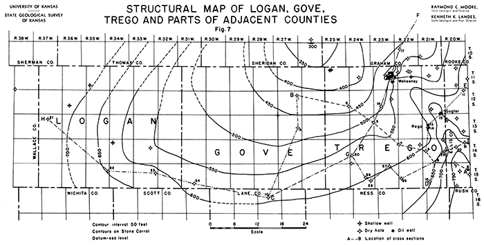
The principal subsurface structural features of Logan, Gove, and Trego counties, indicated by contours drawn on the top of the Stone Corral, are an anticline in eastern Trego County and a broad shallow basin which underlies most of Gove County.
The highest point structurally in the three counties is in the southeast corner of T. 13 5., R. 21 W., where the axis of the anticline crosses the eastern line of Trego County. The anticline extends northwestward from that point through the center of T. 10 5., R. 23 W., into Graham County. It plunges northward at the rate of about ten feet per mile.
The deepest part of the basin to the west of the anticline in the three counties is in the northeast corner of Gove County. From that point the surface of the Stone Corral rises in a northward direction at the rate of about ten feet per mile.
The anticline and the adjacent basin in Trego County are northwestward projections of the same structural features which extend across southwestern Ellis and eastern Rush counties [Landes, Kenneth K., and Keroher, Raymond P., Geology and oil and gas resources of Rush County. Kansas Geological Survey, Mineral Resources Circular 4, p. 17, 1938, available online.].
By far the greater part of the drilling in the three counties has been on the structurally high area overlying the anticline in Trego County; consequently the control in western Trego and all of Gove and Logan counties is very poor. Only three wells have been drilled in Gove County, and only four in Logan County were deep enough to reach the Stone Corral. Because of this lack of control, structure maps drawn on the basis of the present information may need correction when additional data become available.
Figure 7--Structural map of Logan, Gove, Trego, and parts of adjacent counties.
Five cross-sections have been compiled in order to aid the study of subsurface geological conditions in Logan, Gove, and Trego counties. These sections are drawn so as to include all wells for which relatively accurate data were available. A brief discussion of each section follows:
Section A-B (Plate I) extends in a northeast-southwest direction from a point in southwestern Ellis County to sec. 11, T. 12 5., R. 27 W., in Trego County. In the Stanolind No. 1 Wann well in sec. 12, T. 15 5., R. 20 W., the basal Pennsylvanian conglomerate rests on the Cambrian sand. From this well the older Paleozoic rocks dip rather sharply northwestward to the lowest point in the section, in the J. J. Hall No. 1 Dienes well in sec. 12, T. 13 5., R. 24 W., from which point they again rise gradually. The relief on the Arbuckle surface in this cross section is about 640 feet. The same structural relationship is apparent in the younger Paleozoic and Permian rocks, but the amount of relief is much smaller. The total relief on the Stone Corral is approximately 250 feet.
Interesting features to be noted in this cross-section are the absence of pre-Pennsylvanian rocks over the top of the central Kansas uplift, and the greatly increased thickness of the Pennsylvanian rocks below the Kansas City and the Mississippian rocks in the syncline west of the anticline in eastern Trego County.
Section B-C (Plate IV-A) shows the relationship of the underlying rocks along the north-south axis of the basin in Gove County. The thickening of the Mississippian rocks northward between the Bates and Trigg Nimmocks No. 1 well in sec. 16, T. 16 5., R. 28 W., and the Johnson-Atlantic No. 1 Wright in sec. 11, T. 12 S., R. 27 W., as compared to the fairly uniform thickness of the overlying Kansas City group is to be noted.
All the wells included in section D-E (Plate IV-B) are situated high on the anticline in eastern Trego County. In this section the Mississippian rocks are entirely absent and only a few feet of basal Pennsylvanian rocks is present. The maximum thickness of the Arbuckle penetrated by the drill in these wells is less than 500 feet, which is probably close to the total thickness in this belt. The younger Paleozoic and Permian rocks conform to the structure of the oldest sedimentary rocks present, although the amount of relief decreases progressively upward.
Section F-G (Plate II) extends southwestward from a producing well, the Continental Oil Company's No. 1 Morrell, in sec. 15, T. 9 S., R. 21 W., Graham County, through the Wakeeney field. The general direction of the section is at nearly right angles to the axis of the anticline in eastern Trego County.
It is interesting to note that in both cases where production was obtained along this line the oil was found at a point where the rate of dip changed perceptibly.
A thickening of Mississippian and lower Pennsylvanian rocks in the basin to the west of the anticline can be observed in this section. The total relief on the Arbuckle surface is approximately 790 feet. The total relief on the surface of the Stone Corral along the same line is less than 80 feet.
Section H-I (Plate III) extends from the southwest corner of Ellis County along the south line of Logan, Gove, and Trego counties for the greater part of its length. It shows the structural relationships of the rocks on the highest part of both the anticline in Trego County, and across the basin in Gove County. An interesting feature of this section is the gradual thickening of the Mississippian rocks to the west and south.
The maximum relief on the top of the Arbuckle shown in this cross section is 660 feet. The maximum relief on the top of the Lansing is 100 feet, which is almost exactly equal to the relief on the Stone Corral. The much lower relief on the Lower Pennsylvanian rocks shows that by far the greater amount of folding took place before deposition of Pennsylvanian sediments.
The maximum relief on the pre-Cambrian surface is about 1,120 feet. Because the relief on the pre-Cambrian surface exceeds that of the top of the Arbuckle by almost exactly the amount of the thickening of the Arbuckle, it appears that the Arbuckle was deposited on an essentially level surface.
The seven wells drilled in Logan County have all been dry holes. The first three wells drilled, which bottomed in the upper Permian, were too shallow to reach the deeper producing formations of western Kansas. These wells were the Union Pacific Railroad's No. 1 Winona in sec. 30, T. 11 S., R. 35 W., which was abandoned at a total depth of 1,355 feet, the Smoky Hill Oil and Gas Company's No. 1 Armstrong well, sec. 20, T. 12 5., R. 36 W., abandoned at a depth of 1,600 feet, and the Chapple Oil and Gas Company's No. 1 Pettison well, sec. 6, T. 14 5., R. 34 W., which was abandoned at 1,900 feet.
The first well which penetrated the deeper formations was the Coons et al. No. 1 Moffett in sec. 14, T. 14 5., R. 33 W. This well was abandoned as a dry hole in June, 1927, at a total depth of 3,855 feet in the Lansing-Kansas City formation. The Alma Oil Company's No. 1 Watchorn well, sec. 13, T. 15 S., R. 33 W., was drilled in 1935. It was dry and abandoned at a total depth of 5,750 feet in the pre-Cambrian. Two other deep tests were drilled in this county. The Morgan, Flynn et al. No. 1 McMillen well, sec. 9, T. 13 S., R. 37 W., was abandoned in November, 1937, as a dry hole at a total depth of 5,465 1/2 feet in the Arbuckle. The Rose Spring Drilling Company et al No. 1 Wright well, sec. 12, T. 15 5., R. 35 W., which was finally completed in May, 1937, was also unsuccessful. After losing the hole at 3,909 feet, the rig was skidded and a second well drilled to a total depth of 4,910 feet in the Arbuckle.
Three dry holes have been drilled in Gove County. The first well drilled, the Plateau Oil Company's No. 1 Franz, in sec. 27, T. 15 5., R. 31 W., was abandoned at a total depth of 3,850 feet in the Shawnee group. This was in 1922. The second well drilled in Gove County was the Valerius et al. No. 1 Sampson well in sec. 24, T. 13 5., R. 27 W. It was abandoned in January, 1931, at a depth of 4,813 feet in the Arbuckle. The third well, the Johnson-Atlantic No. 1 Wright in sec. 11, T. 12 5., R. 27 W., was abandoned in February, 1931, at a total depth of 4,856 feet in the Arbuckle.
The first well in Trego County was the Mississippi Valley Oil Company's No. 1 Kyser in sec. 9, T. 11 S., R. 22 W., which was drilled in 1923. It was dry and abandoned at 1,406 feet in the upper Permian.
Four other dry holes were drilled in Trego County before August, 1930, when the first producer was brought in. This well was the Central Commercial Oil Company's No. 1 King well in sec. 20, T. 13 5., R. 21 W. It was first completed for an initial production of 286 barrels in the conglomerate. Later it was deepened to 4,094 feet, and then plugged back to 3,965 feet and completed for a poteniial of 20 barrels of oil.
A total of forty-eight wells have been drilled in Trego County, of which sixteen were producers and thirty-two were dry holes.
A complete list of the wells drilled in Logan, Gove, and Trego counties follows:
| Well Completions in Logan County | |||||
|---|---|---|---|---|---|
| Company | Farm | Location, Section |
Compl. Date. | Total Depth | Prod., Bbls. |
| Township 11 S., Range 35 W. | |||||
| Union Pacific R.R. | Winona 1 | SE SE Sec. 30 |
7/27/23 | 1355 | Dry |
| Township 12 S., Range 36 W. | |||||
| Smoky Hill O.G. | Armstrong 1 | NW SE SE Sec. 20 |
--- | 1600 | Water |
| Township 13 S., Range 37 W. | |||||
| Morgan Flynn et al. | McMillen 1 | C NW Sec. 9 |
10/27/37 | 5465 1/2 | Dry |
| Township 14 S., Range 33 W. | |||||
| Coons et al. | Moffett 1 | NW NE NW | 7/5/27 Sec. 14 |
3855 | Dry |
| Township 14 S., Range 34 W. | |||||
| Chapple O. and G. | Pettison 1 | SE SE Sec. 6 |
6/24/22 | 1900 | Dry |
| Township 15 S., Range 33 W. | |||||
| Alma Oil Co. | Watchorn 1 | C SW NE Sec. 13 |
10/29/35 | 5750 | Dry |
| Township 15 S., Range 35 W. | |||||
| Rose Spring Drlg. Co. et al. | Wright 1-A | C SE SE Sec. 12 |
5/12/37 | 4910 | Dry |
| Well Completions in Gove County | |||||
| Township 12 S., Range 27 W. | |||||
| Johnson-Atlantic | Wright 1 | C SE NE Sec. 11 |
2/3/31 | 4856 | Dry |
| Township 13 S., Range 27 W. | |||||
| Valerius et al. | Sampson 1 | NW NW Sec. 24 |
1/16/31 | 4813 | Dry |
| Township 15 S., Range 31 W.; | |||||
| Plateau Oil | Franz 1 | C SW Sec. 27 |
7/29/22 | 3840 | Dry |
| Well Completions in Trego County | |||||
| Township 11 S., Range 21 W. | |||||
| R. E. Day | Eaton 1 | NE NW SW Sec. 2 |
3/3/30 | 3871 | Dry |
| Manning and Martin | Lynd 1 | NW SW Sec. 16 |
3/23/38 | 4057 | Dry |
| Township 11 S., Range 22 W. | |||||
| R. B. McNeeley-Rose Spring Drlg. | Lemke 1 | NW SW Sec. 7 |
10/25/36 | 4040 | Dry |
| Miss. Valley Oil | State Bank 1 | C E2 Sec. 9 |
6/2/25 | 3892 | Dry |
| Miss. Valley Oil | Kyser 1 | SE SW NE Sec. 9 |
10/30/23 | 1406 | Dry |
| Norbla Oil Co. et al. | Burkett 1 | C SW Sec. 15 |
2/23/37 | 4239 | Dry |
| Township 11 S., Range 23 W. | |||||
| Alma Oil Company | Lemke 1 | C SE SE Sec. 10 |
5/13/35 | 4023 | 25 |
| Alma Petro-McNeeley | Hickman 1 | C SW SW Sec. 11 |
11/25/34 | 3681 | 882 |
| Alma Petro-McNeeley | Hickman 2 | C SW SE Sec. 11 |
8/3/35 | 3510 | 504 |
| Alma Petro-McNeeley | Rhoades 1 | C SW SW Sec. 14 |
8/29/34 | 4222 | 346 |
| Alma Oil Company | Rhoades 2 | C NW NE Sec. 14 |
12/29/35 | 3563 1/2 | 70 |
| Watchorn Oil | Hamilton 1 | C SE SW Sec. 14 |
6/25/36 | 3587 | 385 |
| Alma Oil Company | Kraus 1 | C SE SE Sec. 15 |
5/22/36 | 3575 | 459 |
| Watchorn O. and G. | Kraus 2 | C SW NE Sec. 15 |
10/21/36 | 3679 | 428 |
| Watchorn O. and G. | Lemke 1-A | C SE SW Sec. 15 |
8/11/37 | 3510 | 656 |
| Watchorn O. and G. | Lemke 2-A | SE NE SW Sec. 15 |
7/23/37 | 3975 | Dry |
| Watchorn O. and G. | Galloway 1 | C SE NE Sec. 16 |
3/3/37 | 4125 | Dry |
| Dawson and Tharp | Wilson 1 | C NE NE Sec. 22 |
2/23/37 | 4005 | Dry |
| Watchorn O. and G. | Wilson 1 | NW NE NW Sec. 22 |
6/6/37 | 3501 | 400 |
| Continental Oil Co. | Carpenter 1 | C NW NW Sec. 23 |
9/9/36 | 3777 | 10 |
| Continental Oil Co. | Holcomb 1 | C EL NW Sec. 26 |
4/5/36 | 3654 | 616 |
| Continental Oil Co. | Holcomb 1-A | C WL NE Sec. 26 |
7/7/36 | 3631 | 495 |
| Township 11 S., Range 24 W. | |||||
| Keys Petro. | Davidson 1 | NE SW Sec. 16 |
11/16/24 | 3560 | Dry |
| Township 11 S., Range 25 W. | |||||
| Keys Petro. | Walsh 1 | NW SE Sec. 5 |
11/16/24 | 1365 | Dry |
| Keys Petro. | Walsh 2 | NE SE SW Sec. 5 |
11/16/24 | 1542 | Dry |
| Township 12 S., Range 21 W. | |||||
| Mid-Kansas O. G. | Ridgeway 1 | NEc SW Sec. 28 |
12/3/29 | 4278 | Dry |
| Colin L. Campbell | Duncan 1 | SEc SE Sec. 35 |
5/23/37 | 3875 | Dry |
| York State Oil Co. | Gugler 1 | SWc SW Sec. 36 |
11/6/36 | 3839 | 288 |
| Township 12 S., Range 23 W. | |||||
| Phillips Petro. | Trego 1 | C SE NW Sec. 14 |
12/1/37 | 4290 | Dry |
| Jeomar Oil | Jones 1 | SEc SE Sec. 20 |
6/12/35 | 4385 | Dry |
| Township 12 S., Range 25 W. | |||||
| Phillips Petro. | Spitz 1 | SEc SE Sec. 24 |
1/13/30 | 4670 | Dry |
| Township 13 S., Range 21 W. | |||||
| Central Comm. | Hagg 1-A | NWc SE Sec. 17 |
7/10/36 | 4563 | 8 |
| Central Comm. | King 1 | NE SW NE Sec. 20 |
8/16/30 | 3953 | *286 |
| Central Comm. | King 2 | SE SW NE Sec. 20 |
5/22/34 | 4453 | Dry |
| Township 13 S., Range 24 W. | |||||
| J. J. Hall et al. | Dienes 1 | SEc SE Sec. 12 |
10/26/36 | 4857 | Dry |
| Township 14 S., Range 21 W. | |||||
| Olson Drilling | Lang 1 | SEc NW Sec. 1 |
11/12/35 | 4134 | Dry |
| Dixie Oil | Reitmayer 1 | C NE NE Sec. 19 |
5/28/30 | 4456 | Dry |
| Producers and Refg. | Kingsley 1 | SE NW NE Sec. 24 |
1/15/30 | Dry | 3983 |
| Black Gold Petro. | Taylor-Allman 1 | SW SW Sec. 34 |
3/19/37 | 3990 | Dry |
| Township 14 S., Range 22 W. | |||||
| Thurman Hill et al. | Lawson 1 | SW NW Sec. 7 |
11/20/37 | 4398 | Dry |
| Central Comm. | Locker 1 | SW NE SW Sec. 12 |
10/25/37 | 4731 | Dry |
| Township 14 S., Range 24 W. | |||||
| Marathon Oil and Gas | Kline 1 | SWc SE Sec. 19 |
12/27/34 | 5144 1/2 | Dry |
| F. L. Thorne | Koepper 1 | SE SW Sec. 31 |
9/21/37 | 4429 | Dry |
| Township 15 S., Range 21 W. | |||||
| Prairie Oil and Gas | Kutina 1 | NE SW NE Sec. 29 |
3/6/30 | 4383 | Dry |
| Township 15 S., Range 22 W; | |||||
| W. I. Southern, Inc. | Latimer 1 | NW NW SE Sec. 19 |
8/6/37 | 4853 | Dry |
| Township 15 S., Range 23 W. | |||||
| J. C. Shaffer, Inc. et al. | Rogers 1 | SW NE SW Sec. 3 |
7/15/37 | 4638 | Dry |
| Township 15 S., Range 24 W. | |||||
| Manning and Martin, Inc. et al. | Hille 1 | C SE NE Sec. 22 |
11/7/37 | 4726 | Dry |
| Vickers Petro.-Olson | Secor 1 | NW NW Sec. 25 |
1/19/36 | 4727 | Dry |
| *Deepened to 4094. Plugged back to 3965. I.P. 20 Bbls. | |||||
The discovery well for the Rega field mas the Central Commercial Oil Company No. 1 King well in sec. 20, T. 13 S., R. 21 W. This was the first successful well in Trego County. Oil was found in the basal Pennsylvanian conglomerate at a depth of 3,960 feet. The only offset well drilled failed to find oil. The Central Oil Company No. 1 Wagg in sec. 17, T. 13 5., R. 21 W. had an eight barrel show in the Arbuckle at 4,563 feet.
The Wakeeney was the second pool found in Trego County. The discovery well was the Alma Petroleum Company No. 1 Rhoades well in sec. 14, T. 11 5., R. 23 W., which was drilled in August, 1934. Production is from the Lansing-Kansas City at 3,619 feet. So far sixteen wells have been drilled in the Wakeeney field, of which only three were dry. The area surrounding two of the producing wells, the Continental Oil Company's Holcomb No. 1 in the center of the east line of the northwest quarter of sec. 26, T. 11 S., R. 23 W. and the Holcomb No. 1-A, center of the west line of the northeast quarter of sec. 26, T. 11 5., R. 23 W., drilled in 1936, was formerly known as the Holcomb pool. This name has been dropped and the wells included in the Wakeeney field.
Figure 8--Structural map of the Wakeeney oil field
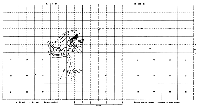
Structurally, the Wakeeney field overlies a relatively small local "high" which occurs at or near the crest of the larger anticline which crosses eastern Trego County. Structure contours drawn on the top of the Stone Corral outline an irregular dome with a closure of over 30 feet. As outlined at present, the field covers an area of about 2,000 acres.
The Gugler is a one well pool. This well is the York state Oil Company No. 1 Gugler in sec. 36, T. 12 5., R. 21 W., completed in November, 1936. Two producing horizons were found, one in the Pennsylvanian basal conglomerate at 3,750 feet, and the other in the Arbuckle at 3,830 feet, but the well is now shut in due to lack of transportation facilities.
Only seven wells deep enough to test the western Kansas producing formations have been drilled in these counties (see tabulated list of wells on preceding pages). These few widely scattered unsuccessful tests are not adequate to condemn the area. The same formations which produce elsewhere in western Kansas are present in both counties.
The greater part of the drilling in Trego County has been confined to the area overlying the anticline in the eastern part. The known occurrence of oil in the Wakeeney, Gugler, and Rega pools should be sufficient incentive to test thoroughly the entire area overlying the anticline.
None of the three fields which have been discovered to date has been definitely defined, although offset wells in both the Gugler and Rega pools appear to limit production in one direction. There still remains room for a number of inside locations in the Wakeeney field. The presence of only three dry holes in this field indicates that it may be extended considerably in the future. A likely direction of expansion is in a northwest-southeast direction along the axis of the anticline upon which the field is situated.
There are no direct pipe line connections for the producing fields of Trego County. The oil produced at the present time is transported by truck to the Kaw Pipe line at either the Ruder or Gorham fields.
Kansas Geological Survey, Logan, Gove, and Trego Counties, Kansas
Placed on web April 28, 2014; originally published in February 1939.
Comments to webadmin@kgs.ku.edu
The URL for this page is http://www.kgs.ku.edu/Publications/Bulletins/MRC11/index.html