Kansas Geological Survey, Mineral Resources Circular 7, originally published in 1937
Originally published in 1937 as Kansas Geological Survey Mineral Resources Circular 7. This is, in general, the original text as published. The information has not been updated. An Acrobat PDF version (7 MB) is also available; large maps available separately.
This report on two of the northwestern counties of Kansas is not an exhaustive treatise on the geology and underground mineral resources of the area considered. It undertakes to state the main features of known geologic conditions, however, especially as these relate to water supplies. Rawlins and Decatur counties have possibilities of wealth from oil or gas production as is true of many other western Kansas counties, but water is an underground resource of greatest possible importance to the residents. Knowledge of the conditions that affect water supply in the High Plains country ia very practical and immediately useful. Accordingly, this paper is published in order to make available to citizens of these counties scientific information not otherwise readily available.
Plans are made for future more extended investigation of underground water supplies in various parts of Kansas, this work to be done by the State Geological Survey and United states Geological Survey in cooperation, possibly with participation also of the State Board of Health and Division of Water Resources of the State Board of Agriculture. The State Board of Health is now engaged with the state and Federal surveys in certain underground water studies.
It should be noted that Mr. Elias, author of this report, has not had opportunity to read the final draft of the manuscript, because of his absence from Kansas for the purpose or geologic work in South America.
Raymond C. Moore
State Geologist
Ground water is one of the most valuable of the mineral resources of the semi-arid western third of Kansas. Most of the land surface is mantled with deposits of loess or yellow dirt which is from a few feet to 150 feet thick. This loess forms a rich soil, only an insignificant part or which was blown away by the severest dust storms which have passed over this country during the last few years.
Few wells in Rawlins and Decatur counties have gone dry during years of drought. Excessive evaporation and deficiency in precipitation resulted chier1y in considerable reduction or water in the few natural and artificial open water storages: rivers, creeks, ponds and lakes.
In spite of greater use of water for domestic supplies, for watering cattle, and for irrigation or gardens and a few orchards, most wells of the area met the emergency of these drought years and never have been pumped dry. The few wells that failed have been cleaned or drilled deeper, or replaced by new wells drilled near by.
The emergency need for water has been met successfully on nearly every farm. In some cases valuable exploratory work has been carried on leading to discovery of deeper and larger sources of water supply. This water, comming in part from a depth or 225 feet, has been used for experimental irrigation.
Record of these new developments is given in this report, which also furnishes geologic substantiation of the probable occurrence throughout the area of adequate quantities of water at depths not exceeding 225 feet. Development of irrigation plants for utilization or this moderately deep water and of the much shallower water in the main valleys or the area, is considered of great importance in furthering the prosperous development of this part of Kansas.
Rawlins and Decatur counties lie in the northwestern part or Kansas. They lie next east of Cheyenne County, which is the north-easternmost county of the state. This area is a part of the High Plains, a physiographic province that comprises the elevated, gently east-sloping land surface, stretching eastward tram the Rocky Mountains and including the western third of Kansas. The area is traversed by Driftwood, Beaver and Sappa creeks and their tributaries, which run in a general direction from WSW to ENE. The valleys of these streams reach below the land of sheet water in the intervening uplands. The sheet water of the separated inter-stream areas is connected toward the southwest into a single body of underground water.
For various information in regard to water and other natural resources of the area I am indebted to the citizens of Cheyenne, Rawlins and Decatur counties. The particularly important information in regard to water available for irrigation has been given by the owners of irrigation plants and by superintendents of city water plants--the sources of this information are given in appropriate parts of this report.
The surface of Rawlins and Decatur counties is mantled by the Quaternary loess (yellow dirt) which overlies the sandy Tertiary sediments that outcrop along the slopes of the larger valleys. The Pierre shale of Cretaceous age occurs in the bottom of Beaver Creek valley in the valleys of the north and south branches of Beaver Creek for some distance above their confluence and in Sappa Creek. This shale is impervious, preventing downward movement of the water, which is thus retained in the alluvium of the valleys above the Shale. The same shale furnishes an impervious substratum for the sheet-water in the Tertiary rocks on the divides between the valleys. The rocks that underlie the Pierre shale do not outcrop in the described area but they have been encountered in deep wells. The description of these rocks and discussion of their relation to deeper water horizons is based on the logs and samples from these wells.
Alluvium--The floors of the principal valleys and their tributaries are composed of sand, gravel and clay. These materials, deposited by running water, comprise the alluvium, which ranges in thickness from 10 to 20 feet in smaller valleys to as much as 60 feet in the principal valleys of Beaver and Sappa creeks. Above the alluvium and along the sides of the valleys is re-deposited yellowish loess, the upper part of which is darkened by humus. The lower part of the loess is mixed with sand and is underlain by sand and gravel, in which locally are thin discontinuous layers of clay.
Sanborn loess--This formation covers the greater part of the area studied. Originally it was practically a continuous deposit but the larger streams have subsequently cut through it, exposing the Tertiary and Cretaceous rocks that underlie it. In most places the Sanborn formation is composed primarily of loess deposits, that is, fine silt, with a few sand grains mixed with it at the base. However, where the Sanborn overlies strongly eroded ancient surfaces, as for instance in the northwestern corner of Cheyenne County south of Arikaree River, the lower part of it is locally composed of sandy loess and clayey sands and gravels which have been largely supplied by Tertiary rocks. In part these arenaceous layers may belong to a distinct formation from the Sanborn, but at present there are no fossils or other evidence on which separation of these rocks from the Sanborn can be based. At least a part of the sands and gravels at the base of the Sanborn formation, that appears as unsorted sandy loess and clayey sand and rubble, seems to be logically interpreted as a basal part of the Sanborn, for these deposits grade without visible break into the loess.
There is very little sand (ordinarily 1 or 2 feet) and gravel at the base of the Sanborn loess in Rawlins and Decatur counties. This sandy basal portion of the formation is not continuous and it contains only insignificant amounts of water. The Sanborn averages from 50 to 140 feet in thickness.
Loveland (?) formation--In the northeastern quarter of Decatur County there is a darker brownish ("red") loess that underlies the light yellowish buff Sanborn loess with distinct erosional unconformity but without any traces of ancient soil between. The "red" loess is provisionally classed as equivalent to the Loveland formation of Iowa and Nebraska. This loess is from 20 to 30 feet thick.
Ogallala formation--The Ogallala is composed chiefly of sand. It is the chief water-bearing formation in Rawlins and Decatur counties. The rocks of the Ogallala formation outcrop along the slopes of most valleys as either fairly continuous or as locally isolated bluffs of "mortar beds" and "magnesia" rock. The picturesque bluffs on the south side of Beaver Creek at Cedar Bluff are a good example of such outcrops. The average thickness of the Ogallala formation in this area is 100 to 200 feet. It is composed chiefly of unsorted grit and loam impregnated with calcium carbonate. Although sand particles and occasional small sized pebbles can be seen in almost any piece of rock of the Ogallala, fine silt is also almost always present. Locally, however, this silt so predominates as to make portions of the ogallala impervious to the circulation of water. On the whole, the Ogallala may be considered as a good aquifer. The lower half of it is saturated with water. This water does not circulate through it with equal speed because locally the circulation is practically stopped by the silty portions. In such cases the water moves around the silty portions, travelling through the more pervious sands and gravels.
Part of the Ogallala sediments is loose and part is cemented. Cementation may be very local, especially in the lower strata of the formation, but ordinarily the cemented "mortar beds" are continuous over tens of miles. The "mortar beds" are only partly cemented in most cases, and they allow circulation of water through the rock, but locally impervious beds in the Ogallala formation act as a barrier to downward-moving water and create a division of the Ogallala water into two or more distinct zones. It appears, however, that these water-bearing zones are not entirely disconnected and that water in the Ogallala may therefore be considered a single sheet that has within it relatively impervious and silty portions.
Woodhouse clays--The Woodhouse clay, originally described by me in Wallace County, is a very local clayey formation that is wedged in between the sandy Ogallala beds above and the Pierre shale below. In the area here described, it has been found only on the south side of North Beaver Creek, 1 to 2 miles west of Atwood. The formation consists of silts and fine silty sands, with coarser sand to conglomerate at the base, and chocolate to maroon plastic clays in the upper part. The formation ranges in thickness up to 60 feet and is largely impervious to water.
Pierre shale--The Pierre shale, which is exposed in a few places along the valley of the larger creeks, varies in thickness chiefly according to the amount of pre-Tertiary erosion. In the east, at Norcatur, Decatur County, it thins to about 100 feet and about 15 miles farther east, in the central part of Norton County, it is entirely eroded away and the Niobrara chalk directly underlies the Tertiary Ogallala beds. At Kanona, Decatur County and farther west to the Rawlins County line, the thickness of the Pierre increases to 600 feet, and in central Rawlins County, a few miles west of Atwood, it is trom 900 to 1,200 feet thick (Figure 1).
Figure 1--Geologic section through deep wells to show correlation of rocks and horizons of water.
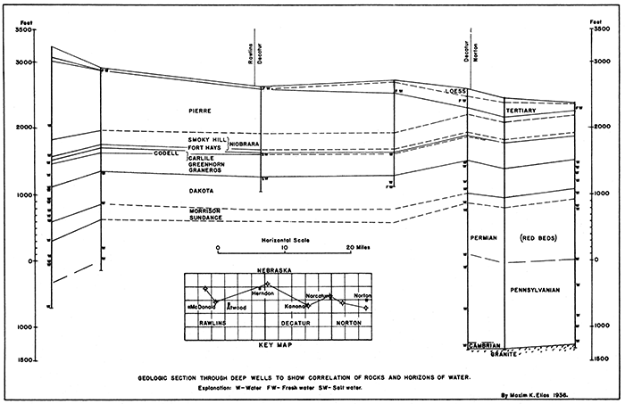
In the Dancinger well north of Beardsley, Rawlins County, a little water has been encountered in sandy shale 200 feet above the base of the Pierre.
Niobrara chalk--The Niobrara chalk is about 750 feet thick along Smoky Hill River, but it thins toward the Nebraska State line. [Elias, M. K., Geology of Wallace County: State Geological Survey of Kansas, Bull. 18, 1931, pp. 35-37, available online] Interpretation of the most reliable well logs of RaWlins and Decatur counties and surrounding area, indicates that here the Niobrara is only about 3OO feet thick. In the northeastern part of Sheridan County its thickness, based on interpretation of well logs, increases to about 400 feet and it also apparently increases to the northeast in Nebraska, where reliable data on a well south of Campbell, Franklin County, indicate a thickness of Niobrara chalk ot 415 feet. [Condra, Schramm, and Lugn, Deep Wells of Nebraska: Nebraska Geol. Survey, Bull. 4, 2d ser., 1931, pp. 215, 216.]
Smoky Hill chalk member--In Rawlins and Decatur counties, this upper chalk member of the Niobrara formation is about 250 feet thick. In the eastern part of Decatur County, no differention between the Smoky Hill chalk and the underlying Fort Hays limstone can be made from the drillers' logs.
Fort Hays limestone member--The thickness of this member in the' western part of Decatur and in Rawlins County is about 50 feet.
Carlile shale, Greenhorn limestone, and Graneros shale--According to well logs studied, the interval between the Niobrara beds above and the Dakota group below, is made of bedded shales, sands and chalky limestones with greater amounts of shale at the top (Carlile shale) and at the base (Graneros shale). The well logs do not furnish sufficient information for determination of definite boundaries of the Greenhorn limestone, which lies betWeen the Carlile and Graneros shales. The combined thickness of these undifferentiated members is 350 to 380 feet. Sandstone, locally including conglomerate, which occurs at the top of this interval, according to many well records, represents the Codell sandstone.
Dakota group--The Dakota group is recognized in the deep wells by its predominantly sandy character and considerable water content. In Rawlins and Decatur counties it is some 450 to 520 feet thick. Besides the predominant sandstones, some shales, conglomerates, and limestones are recorded from this group of rocks.
Morrison (?) and Sundance (?) formations--Below the sandstones of the Dakota group and above Permian "red beds", occur shaly beds, the chief character of which is a greenish color, especially toward the middle of the sequence. This formation is from 250 to 290 feet thick in Rawlins County and thins to about 150 feet in the eastern part of Decatur and the western part of Norton counties. It has been recognized, and about the same thickness observed in the wells of Sherman County and in the Phillips Petroleum Company Andrews No.1 well, one-half mile west of the Kansas-Colorado State line, northwest of Saint Francis. To the east of Norton County the formation disappears. These green and blue shales seem to correspond to the Morrison formation of Colorado, and the sand and conglomerate below the green shale is possibly equivalent to the Sundance formation.
No detailed correlation of these rocks is needed in this report. Some red sandstones of the Permian system and some limestones of the underlying Pennsylvanian rocks yield mineralized water in deep wells. The total thickness of the Permian, Pennsylvanian, and still older Paleozoic rocks is 1,850 to 2,000 feet. Granite has been encountered below these rocks in eastern Decatur and in Norton counties. A little water has been encountered above the granite.
The area is drained by Driftwood, Sappa and Beaver creeks and their tributaries. Solomon River crosses the southeastern corner of Decatur County. Except after heavy rainfalls, only a little water flows in the channels of the creeks, and in dry years like 1934 and 1936 their continuous surface flow ceases. The artificial lakes, located on such creeks and their tributaries, become smaller and disappear. The lake at Atwood was dry most of the time during the summer of 1936. Water for these artificial lakes can be pumped from the underflow of the creek valleys, the supply of which is quite sufficient for this purpose even in the driest years.
The most important aquifers are the Ogallala formation and the alluvium of the stream valleys. These provide sufficient water at shallow depths throughout the area, not only for domestic supply and ordinary farm use, but also for irrigation. Water from deeper rocks is mostly highly mineralized and salty.
There is a considerable supply of water in the alluvium of all the larger valleys. In the smaller valleys the alluvium averages from 10 to 25 feet thick, and water is obtained in most cases from shallow wells. In the larger valleys of Beanr and Sappa creeks, the alluvium is as much as 75 feet thick. The county seats, Atwood and Oberlin, and a few other towns obtain a sufficient amount of this water for municipal needs. The quantity of water drawn from these wells and from wells used to supply water for irrigation is relatively large in amount. It indicates the adequacy of the water supply in the valley alluvium.
Beaver Creek--Atwood is located at the junction of North and Middle Beaver Creeks. Its water supply is furnished by three wells at the power house. Well No. 3, which is pumped most of the time during the year, is 51 feet deep, and the other two wells, used in emergency cases of during repairs of well No. 3, are approximately the same depth. The bottom of the well is in shale that underlies the gravel or the alluvium. Water fills the lower 22 feet of the well. The inner casing is 15 inches and the outer is 22 inches in diameter.
The log of the well, from top to bottom, follows:
| 5. Sandy loam | 15 feet |
| 4. Clay | 20 feet |
| 3. Blue clay | |
| 2. Pine sand | 1 foot |
| 1. Coarse gravel (cobbles to 3 to 4 inches in diameter) | 15 feet |
| 51 feet |
The water is pumped by a Layne and Bowler turbine, with a maximum capacity of 320 gallons per minute. According to the plant superintendent, Mr. Snyder, the city consumed 52,000,000 gallons of water in the period from September 1, 1935, to September 1, 1936, the average-monthly consumption being, therefore, about 4,335,000 gallons.
The two largest irrigation plants along Beaver Creek are located at Traer and Cedar Bluff in Decatur County. Paul A. Nitsch irrigates bottom land in the SW sec. 30. T. 1 S., R. 29 W., 2 miles east of Traer. Eighty acres are actually under irrigation and a total of 100 acres may be irrigated. Alfalfa that has been raised on this land yielded four cuttings in 1935, and two cuttings and one seed crop in 1936. The yield of seed was 1 3/4 bushels per acre, but could be, according to an estimate by Mr. Nitsch, 6 or 7 bushels if it were not damaged by grasshoppers. The field was irrigated four times in 1936, but in years of normal rainfall two irrigations are sufficient. Water is pumped from a 75-foot well that has 40 feet of water. The well log follows:
| 5. Soil, clay and clayey sand First water |
32 feet |
| 4. Sand and gravel | 3 feet |
| 3. Clay Second water |
16 feet |
| 2. Gravel | 24-25 feet |
| 1. Shale |
The casing is 24 inches in diameter. A Pomona turbine pump draws 1,000 gallons per minute (pumping capacity 1,200 gallons per minute), the power for which is supplied by a 30 H.P. tractor motor; the necessary power could be supplied, however, by a 25 H.P. motor. The cost of the well was $5.00. per foot, including the casing, and the cost of the pump $735.00 plus $25.00 for installation.
Al Macy irrigates bottom land in the SE NE sec. 10, T. 1 S., R. 29 W., one-eighth of a mile north of Cedar Bluft, with surface water. Twenty-four acres, which are under irrigation, produce watermelons, corn, and other vegetables. The average corn crop is 60 bushels per acre. The field was irrigated four times in 1936, but in years of normal rainfall one irrigation is sufficient. Water is pumped directly from the creek, but Mr. Macy intends to dig a pit in the highest (southwest) corner of the field. The log of an old well at that point follows:
| 2. Black and yellow dirt (to water) | 10 feet |
| 1. Water gravel and sand | 20 feet |
| Total | 30 feet |
The water is pumped by ft centrifugal Fairbanks-Morse 6-inch pump, with an output of 1,200 gallons per minute; the power is supplied by a tractor motor. Period of pumping is about 8 to 10 hours at a time.
Sappa Creek--Oberlin (population 1,629), in Decatur County is located on Sappa Creek. The city water supply is derived from the underflow of the creek valley. According to information furnished by J. E. George, superintendent of the city water plant, the well is 65 feet deep, and has 28 feet of water. The casing is 24 inches in diameter. Ordinarily 100 to 150 gallons per minute are pumped during 12 hours of the day, but during the summer 24-hour pumping is necessary to satisfy the water demands. Many citizens have privately owned wells that obtain water from the same valley underflow.
I. G. Redman irrigates bottom land in the SE SW and in the SW SE of sec. 31, T. 2 S., R. 28 W., about three-fourths of a mile east of Oberlin. Eighty to ninety acres are under irrigation. Alfalfa, grains and vegetables are raised. Water is pumped from a 68-foot well that has been drilled to the Pierre shale. It has 40 feet of water in coarse sand and gravel, the latter containing pebbles one-fourth inch in diameter. One thousand gallons of water per minute are pumped by a Western Land Roller Co. (Hastings) pump. Power is supplied by a 30 H.P. tractor motor, although a 26 H.P. engine would be sufficient for pumping.
These data indicate the presence of a large quantity of water in the valley underflow of both Beaver and Sappa creeks. Irrigation plants on both of these creeks are located near the largest towns, and the combined consumption of water created no shortage, even in the dry years of 1934 and 1936. The numerous privately owned wells in the cities, which are in most cases shallower than those owned by municipalities, did not go dry, but some were abandoned for economic reasons. The cost of maintenance, cleaning and repair of privately owned small wells is in many cases too high in comparison with the price of water supplied by city water plants.
Smaller communities, like Ludell, Rawlins County, with a population of 75, depend entirely on privately owned wells. In the long run, these are more expensive than centralized larger wells, and occasionally cause trouble through pollution. According to Henry Dunker, there are two levels of water in the Beaver Creek valley at Ludell. The first is reached at 30 feet, and the bottom of the second water, which is in gravel, is at 58 feet. The second water is of better quality and of greater flow, and is tapped by most of the wells.
The water in the Ogallala is the so-called "sheet water" of the High Plains and is the main source of water widely used on the divides between the major creeks of the area. Ordinarily the drilled and dug wells pumped by windmills are sunk into the upper 10 to 20 feet of the sheet water only. A few wells go deeper so as to have 30 to 40 feet of water, and only very few wells penetrate through the aquifer into shale. Such wells are usually located in areas of insufficient sheet water.
Areas of insufficient sheet water--The principal area of deficient sheet water in the Ogallala lies in the northwestern corner of Rawlins County. In the basin of Driftwood Creek in the northern and central part of T. 15 S., R. 36 W. there is no sheet water at all due to local thinning and even total absence of the Ogallala between the Pierre shale below and the Sanborn loess above. On the main divide between the two forks of Driftwood Creek in the southwestern part of T. 15, S., R. 36 W. and in the area south and east or this township the wells are usually drilled to the Pierre shale. The Ogallala aquifer is thin in this area ranging from 1 1/2 feet to 14 feet thick. The "yellow soapstone" of the water well drillers beneath the water-bearing Ogallala of this area is Pierre shale which is somewhat more massive and less unctuous than the ordinary gray shale of the Pierre. It is light yellowish-brown in color, and due to its slight porosity does not contain enough water for use. The thickness of the "yellow soapstone" is about 9 feet north of McDonald.
There is no water in the Ogallala for about 5 miles west of Atwood along U. S. Highway 36 on the divide between Middle and South Beaver creeks. The water in this aquifer that is pumped farther west drains into Middle Beaver CreeK through springs on the south side of the creek near Blakeman. The narrow divide east of Blakeman is drained by seepages to the north. No opportunity exists there for the collection of meteoric water in sufficient abundance for use.
Along the southern and much dissected slope of Beaver Creek valley at and below the junction of Middle and South Beaver creeks east of Atwood, no sheet water is ordinarily obtainable within 1 to 1 1/2 miles south of the creek. Here the Ogallala aquifer is divided into narrow wedges and strips between short southern tributaries of Beaver Creek, and the water of this aquifer is drained by numerous springs and seepages located at the contact of the Ogallala with the underlying Pierre shale. A little water may be obtained in the thin alluvium of the short southern tributaries, but more water may be obtained through utilization of the springs.
Springs at Herman Foshe's farm--A good example of utilization of spring water at the contact of the Ogallala with Pierre shale is at Herman Foshe's farm in the SW. cor. of sec. 11, T. 3 S. R. 33 W., 2 miles east and 1 mile south of Atwood. Here the valley fill of a small southern tributary to Beaver Creek is insignificant, and although water can be obtained in very shallow wells (10 to 15 feet) in the draw, it is not plentiful and is apparently restricted to a narrow underground channel. The water that feeds this channel comes from a few springs and numerous seepages on both sides of the valley at the Pierre shale-Ogallala sand and gravel contact. The best two springs are a short distance north and south of the house on the west side of the valley. On the east side of the valley the basal sands and gravels of the Ogallala are met, but no springs occur except farther down (north) along the valley. The road cut east of the house exposes the Pierre shale surface at an elevation about 15 feet higher than on the west side. This seems to be a local elevation in the pre-Ogallala topography.
Insufficient water at John S. Skoloutt farm--An instructive example of the absence of shallow water in narrow zones along underground divides of sheet water can be observed at the John S. Skoloutt farm in the SE SE sec. 35, T. 5 S., R. 35 W. Many dry wells have been drilled at and around the farm. Wells with plentiful water surround this area, but all are located within a short distance of draws, ravines, and the shallow broad depressions at the heads of the principal draws. Unfortunately, exact records of depths of most of these wells have not been kept, but the available information (supplied by Mr. Skoloutt) and a hand level survey of the surface by me indicate that south of the Skoloutt farm there is a very gentle slope of the underground shale surface toward the south-southeast which coincides with the gentle slope of the plateau in the same direction. To the north is a sharp topographical drop caused by the drainage system of Driftwood Creek which cuts deeply into the Sanborn loess and exposes the uppermost part of the underlying sandy Ogallala formation. Elevations taken on the top of the Ogallala (algal limestone) indicate a structural slope of this formation toward the north and northeast. It appears that the Skoloutt place is along the northeastern extension of a gentle anticline which was drilled by the Dancinger Oil Company, but neither oil or gas were encountered in commercial quantities in this well.
Water resources of flat divides--On the flat areas, which are remnants of the High Plains plateau, there is sufficient water, not only for the present population and their stock, but also for some irrigation, as has been proved by a few farmers in Cheyenne County who started to irrigate their fields in 1936. It is not possible to estimate at present how extensive such irrigation may be carried on without depletion of the aquifer. However, my geologic studies indicate, that there is a supply of water available at slightly greater depth than the average depth of the windmill wells beneath the main flat divides of Rawlins and Decatur counties, with the exception of the northwestern and north-central parts of Rawlins County. The irrigation pioneering by the people of Cheyenne County south of Bird City adjacent to Rawlins County, is most instructive in this respect and will be discussed in the following section.
Irrigation on high land south of Bird City--Irrigation plants are located on the north and south sides of Middle Beaver Creek in the southeastern corner of Cheyenne County.
Elmer Ervin pumps water for irrigation from a drilled well 261 feet deep in the southeastern corner of sec. 33, T. 5 S., R. 38 W. There is 80 feet of water in the well. Mr. Ervin found that he could pump about 100 gallons per minute from this well by turbine pump run by an old Rumley tractor engine. Only a small amount of water has been used for irrigation, and feed crops and a big crop of pickles have been produced.
Ralph Weaver was the next to try irrigation on high land. In 1936 he irrigated one acre, but he has about 40 acres that can be conveniently irrigated from his well. He raised a 200 bushel crop of potatoes on this acre; also some corn and watermelons. The water is pumped from a well 168 feet deep, with 53 feet of water at the bottom. The log of this well follows:
| 14. Yellow dirt (loess) | 50 feet |
| 13. Coarse loose sand and gravel | 10 feet |
| 12. Sandy clay First water |
55 feet |
| 11. Coarse sand and gravel | 5 feet |
| 10. Clay Second water |
6 feet |
| 9. Coarse sand | 2 feet |
| 8. Clay | 4 feet |
| 7. Rock (sandy limestone) Third water |
1 foot |
| 6. Quicksand | 5 feet |
| 5. Gravel | 3 feet |
| 4. Clay and white "magnesia" (porous lime stone) |
10 feet |
| 3. Coarse sand | 4 feet |
| 2. Quicksand (to bottom of the well) | 8 feet |
| 1. Rock ("magnesia", a somewhat sandy limestone) has been encountered in a test hole below the water. |
20 feet |
The well is in the NW of the SW of sec. 15, T. 5 S., R. 38 W. A Fairbanks-Morse centrifugal pump produces 350 gallons per minute. The longest period of pumping has been 24 hours. A John Deere 30-H.P. tractor motor has been used for power. The cost of fuel was about 26 cents per hour. The well has been graveled. For inner casing 8 inch pipe is used.
The cost of the plant follows:
| Drilling of well (24" diameter) | $3.00 per foot |
| Casing, plain, to water level, 18 inch diameter | $1.05 per foot |
| Casing, perforated, below water level | $1.85 per foot |
| Pump, 650 gallon capacity, for water 160 feet deep | $1.050.00 |
Walter Eggers built by far the most extensive irrigation plant. In 1936 he irrigated 20 acres and plans to irrigate up to 100 acres. He raised potatoes, obtaining 125 bushels per acre. The smaller yield per acre, as compared with 200 bushels received by Weaver, is explained as due to later irrigation by Eggers.
Water is pumped from a well 225 feet deep with 90 feet of water in the bottom of the hole. The well is in the southeastern corner of the NW of the SW of sec. 15. T. 5 S., R. 37 W. The log of the well follows:
| 16. Yellow dirt (loess) | 25 |
| 15. Limestone, tough, pinkish (algal limestone) |
2 |
| 14. Sandy porous limestone and silt | 23 |
| 13. Gravel and sand | 30 |
| 12. Silt | 6 |
| 11. Gravel | 5 |
| 10. Silt and rock | 6 |
| 9. Gravel and sand | 7 |
| 8. Silt, yellow | 6 |
| 7. Sand and gravel | 8 |
| 6. Silt | 4 |
| 5. Gravel and sand First water |
6 |
| 4. Silt and gravel, with fossil bones | 6 |
| 3. Rock, hard Second water |
2 |
| 2. Gravel. with fossil bones | 12 |
| 1. Soft rock. sand and gravel | 79 |
| Total | 225 |
The well was started at 48 inch diameter and was dug by hand to 134 feet and the walls cemented. The drilled part of the well is 91 feet with 18 inch diameter casing extending to the top of the well. The inner casing is 4 inches in diameter with slots below water level.
A Winthroath pump has been pumping 800 gallons per minute, running about 50 hours during single irrigations with stops at night. Power is provided by an Allis-Chalmers 90-H.P. stationary motor. The motor and pump are housed in a sheet-metal building on cement foundation. An air-cooling system with outside exhaust vents is built around the motor.
The total money invested in the irrigation plant is about $5.500. which includes the drilling of three test holes. Cost of each of these holes was about $150 each. Cost of dug part of irrigation well was $5.00 per foot; of drilled part, including casing, about $7.00 to $8.00 per foot. Cost of pump was $2,100.
August Bussie, north of the Eggers property, pumps about 400 gallons per minure with a Western Company pump driven by a Hercules combine engine. He raised corn. potatoes, tomatoes and beans successfully on irrigated land.
The same Tertiary sheet water at about the same depth is used by city water plants at Bird City in Cheyenne County and at McDonald in Rawlins County.
Bird City water plant--According to Ray Hawk. superintendent, two wels at the Bird City water plant are respectively 226 feet deep with 40 feet of water and 216 feet with 30 feet of water. Diameter of casing in each is 10 inches. Water is pumped at the rate of 68 gallons per minute for about 10 hours a day. The amount of water is not quite sufficient, apparently because the water is obtained from sand and not from gravel, and the wells have not been graveled back of the casings. Sucking of fine sand together with water into the pump is causing much trouble due to cutting of the valves. Graveling of the well will stop this trouble.
McDonald water plant--The wells at this plant are respectively 240 feet with 40 feet of water and 250 feet with 50 feet of water, according to A. J. Fritz, well driller. The casing of the wells is 10 inches in diameter, and the pump is 5 1/2 inches in diameter. Water is obtained from a coarse sand which grades into a gravel in most of the privately owned wells in town.
The log of the city wells follows:
| 4. Yellow dirt (loess) | 100 feet (approximate) |
| 3. "Magnesia" (sandy limestone) | 38 feet |
| 2. Sand and rock | 100 feet |
| 1. Shale |
Water is pumped at the rate of 400 gallons per minute and the consumption is about 3,500.000 gallons a year (1935), or an average of 300.000 gallons per month.
It is interesting to note that a privately owned well 210 feet deep on the opposite side of the same block containing city wells suffered very little lowering of water level at the time of maximum city water consumption in 1936.
Fresh water occurs in the Codell sandstone at the base of the Niobrara in many parts of the area. However, a well in T. 1 S. R. 30 W., Decatur County reports salt water and gas from the Codell horizon. Strong flows of both fresh and mineralized water have been found at different horizons in the Dakota group. The chief aquifers are the uppermost sandstones and beds near the base of the group. In a few wells water bas been found in sands lying beneath the Triassic (?) green shale.
The irrigation plants now in operation use water from two different formations. The plants along the valleys of Beaver and Sappa creeks pump valley underflow from the loose sands and gravels of the alluvium. The new (1936) irrigation plants, on the high land south of Bird City in the southwestern part of Cheyenne County, utilize sheet water from the sandy Ogallala formation.
Utilization of river and creek underflow is naturally limited to the bottoms of the valleys of Beaver and Sappa creeks, which are one-fourth of a mile to 1 mile wide. Numerous tracts of flat land along these valleys are well situated for irrigation. The record of city water plants, and of the few existing irrigation plants along these valleys, indicates the presence of a strong, steady underflow that appears to have been more than adequate for demands even during the years of greatest drought (1934 and 1936). It is probable that only an insignificant part of this valley underflow is now utilized. Development of several more irrigation plants, unless too closely spaced, will not appreciably affect the water level in wells along these valleys.
Location of new wells for irrigation in the valleys does not present particular difficulty, but this does not mean that strong flow sufficient for irrigation can be obtained at any point in the valley bottom. Although the sandy alluvium is saturated with water, movement of water is always strongest along a main channel in the valley fill. It is essential that irrigation wells or pits should be located on this channel. Ordinarily the channel is composed of coarser sands and gravels in the lower part of the alluvium. "Quick-sand" may also produce a strong flow of water, but wells located on quicksands must be carefully back-graveled in order to stop the suction of finer sand along with the water, for withdrawal of this sand causes corrosion of valves and caving of the well. Back-graveling may be suggested for the improvement of almost any well, because even the coarsest natural gravels usually contain a mixture of sand, which is sucked out by pumping. This difficulty is avoided if the sand is replaced by gravel.
The acreage of irrigable lands in the upland region is much greater than that of the valley bottoms, because of the broad nearly horizontal land surface of the uplands and the. presence of adequate supplies of underground water beneath almost all parts of the upland. However, the difficulties and uncertainty in location of irrigation wells are much greater, the water level is much deeper, and in consequence both the original investment in irrigation plant and maintenance expenses are greater.
It has been pointed out that some development of underground water supplies for purposes of irrigation. already exists in Rawlins and Decatur counties, and that these irrigation activities are located both in valleys and in the upland. Question may be raised as to whether these developments depend on locally favorable conditions, and represent utilization of a large share of the total available underground water supply, or, on the other hand, whether present irrigation plants are using a relatively small part of the total available water.
Estimation of underground water reserve is a matter of elaborate research, and must include long time observations of output of water, changes in water table and collecting of other important data which are not now available in this area. It is nevertheless pertinent to discuss the possibility of extensive irrigation in Rawlins, Decatur and adjacent counties, considering this subject from the viewpoint of local experience in irrigation experiments and of known geologic conditions. Besides a general examination of rock formations and their distribution over the studied area, several profiles have been made across Rawlins and Decatur counties (Figure 2): one from west to east along U. S. Highway 36 from the Rawlins-Cheyenne County line west of McDonald to the Decatur-Norton County line east of Norcatur, and two in a north-south direction through Atwood along Highway K 25 and through Oberlin along Highway U. S. 183. The elevations for these profiles were taken with a Paulin altimeter. The elevations of railroad stations along the profiles were used as bench marks. Government elevation bench marks along Highway K 25 were also used. A back check to the starting point of known elevation was usually taken after 1 of 1/2 hours of work, and whenever a great change of atmospheric pressure was registered by the altimeter, the leveling results obtained during this change were discarded and a new set of elevations taken. At the same time elevations were also taken at geologically important points, such as the contact between the impervious Pierre shale and the overlying Ogallala aquifer, and between the latter and the still higher Sanborn loess. Finally, elevations were taken at the water wells at and near the lines of profile and all available data on depth of water and bottom of wells were collected. Profiles showing geologic structure and the relation to it of underground water were constructed from these data (see figures). The study of these profiles together with other information on geology and water obtained during field work permit the following conclusions.
Figure 2--Profiles across Rawlins and Decatur counties of Kansas showing shallow ground water supply.
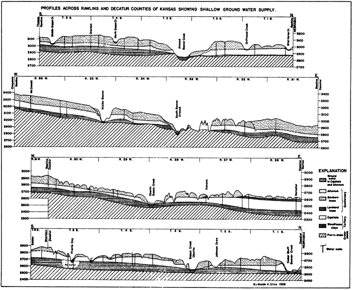
The main water available in the area is in the sandy Tertiary (Ogallala) formation. This is a continuous sheet of water that ordinarily saturates the formation from about 40 to 100 feet above its base. By far the greater number of wells penetrate only the uppermost 15 to 20 feet of this sheet water, and the main part remains unutilized. The saturation of the Tertiary aquifer is not uniform, however, due to the heterogenous composition of the formation. (See paragraph on the Ogallala in the description of the rocks).
The sheet water in the Ogallala is not stationary. It moves very slowly in general to the east, which is the regional slope of the High Plains, but locally may be directed toward the main valleys as the profiles of water table in the geologic sections indicate. The uneven contact between the Tertiary and the impervious Pierre shale has some influence on local thickness and direction of movement of the sheet water. While the sheet water drains through springs and seepages into Beaver, Sappa, and other creek and river systems, and is pumped to the surface through water wells, the water table does not drop but remains practically the same. This indicates continuous water influx from the higher plains to the west and southwest. Undoubtedly the greater part of this water comes from eastern Colorado, because the Tertiary aquifer continues across the state line and is not cut by any deep valleys. To this water is added that part of the local precipitation that finds its way underground along the Tertiary outcrops.
In searching for the moderate amount of water needed for domestic and stock use, wells may be successfully dug or drilled at almost any place on the High Plains with exception of a few limited areas of insufficient water which were previously discussed. However, in order to secure the greater amount of water sufficient for irrigation, special search must be undertaken, and one must be assured that there is enough underground water for irrigation before investing any money on pump, and other accessories. Although the lower part of the sandy Ogallala is saturated with water practically everywhere, this water moves through the formation with different speeds at different places because of its heterogeneous character. The coarser sands and gravels, which are distributed among the finer sandy, clayey and firmly cemented rock portions of the Ogallala, provide continuous channels along which the fastest movement of underground water takes place, and it is this water that is and can be utilized for irrigation. Walter Eggers drilled four test holes on his land, all of which tapped sheet water, but only one, which penetrated gravel, provided him with a yield of 1,000 gallons a minute. To insure constant strong flow, and also to protect the valves of the pump from corrosion by fine sand, an irrigation well must be back graveled.
There is good reason to believe that coarser sands and gravels form a net of interconnected underground channels in the Ogallala which may be encountered beneath nearly every square mile of the High Plains, but it is very difficult to determine the underlying presence of coarse sand and gravel at any particular place from observations on the surface alone; and the only definite way to discover underground water channels is to drill test holes. A suggestion for the search of such channels, and the location of test holes follows.
Because the underground water contains some carbon dioxide, it dissolves the calcium carbonate that is present throughout the sediments of the Ogallala. The fine particles of sand and clay that are bound by calcium carbonate are thereby loosened and gradually move down and settle in lower horizons. As this process continues it weakens the portions of the Ogallala along which there is greater circulation of water. This eventually may cause local settling, or gentle collapse of portions of the Ogallala, which will be reflected on the surface by slight sags in the topography or even by minor cave-ins. These broad depressions and minor cave-ins are of greater magnitude than buffalo wallows. They may be observed throughout High Plains. Ir this theory is correct, these depressions may be used as guides when drilling test holes in search for abundant sheet water for irrigation.
Three different kinds of clay with commercial possibilities occur in the Rawlins-Decatur area. These are the yellow dirt or loess of the Sanborn formation, the chocolate-brown unctuous clay of the Woodhouse formation, and the gray clayey shale or the Pierre formation.
The yellow dirt or loess of the Sanborn formation is not a plastic clay in the ordinary technical sense, but is a compact aggregate of fine sandy to silty particles (compressed "rock flour"). The rock is soft, and has capillary porosity that permits it to suck and hold a considerable amount of water, as if it were a sponge. However, this capillary porosity is too fine to allow circulation of water through the rock and in consequence the saturated rock acts as an impervious barrier to water circulation.
The chemical composition of Wallace County loess follows [Elias, M. K., Geology of Wallace County; State Geol. Survey of Kansas, Bull. 18, 1931, p. 180, available online]:
| SiO2 | 63.33 |
| Al2O3 | 12.92 |
| Fe2O3 | 3.34 |
| CaO | 5.44 |
| MgO | 1.96 |
| Lost on ignition | 9.62 |
Sanborn loess is good material for building cheap dams for reservoirs, but unless stone or cement spillways are provided the dams will be destroyed by overflowing water.
The chocolate-brown unctuous clay of this formation may be used in all probability in making brick and pottery. Also it is a bentonitic clay, and detailed technical analysis may reveal possibilities of utilization in refining oil and for other special technical needs.
In the area under discussion this clay outcrops only in the NE and the SE of sec. 6, T. 3 S., R. 33 W., 1/4 miles northwest of Atwood, Rawlins County. The exact thickness of the bed has not been measured, but the natural outcrop shows at least 5 feet (and probably 6 or 7) of clay with considerable overburden of Tertiary rocks. Because of the overburden the clay bed cannot be stripped, but only mined.
Several localities of the same Woodhouse clay have been recorded and described in Wallace County. [Elias, M. K., Geology of Wallace County; State Geol. Survey of Kansas, Bull. 18, 1931, pp. 153-158, and 208-211, available online]
Portions of the Pierre shale formation, Which outcrops along Beaver Creek near Blakeman, Atwood, Ludell, Herndon, Cedar Bluff and Burntwood, can be utilized for manufacturing red brick where free of pyrite and gypsum, which occur in zones within this formation. The Pierre shale of Kansas has not been studied and tested as ceramic material, but an extensive account of the properties of the Pierre shale in eastern Colorado has been published. [Butler, G. M., Clay of Eastern Colorado: Colorado State Gaol. Survey, Bull. 8, 1914, pp. 114-116, 137, 138 and 297-299.]
Local building stone is provided exclusively by the Ogallala formation. Almost any portion of the sandy Ogallala formation, where cemented, provides satisfactory stone for foundations for farm houses and barns, but the rock never breaks in even slabs or blocks. Some of the so-called "mortar beds" that outcrop in picturesque bluffs along the valleys and draws are only partly and irregularly cemented, and therefore do not make good building stone. The best stone is usually found near the base of the Ogallala where the sand and gravel are locally cemented by chalcedony into very hard sandstone, which may be tinted a beautiful green color. Such sandstone was used in building a new school house at Ludell, Rawlins County. It was quarried in the SE of sec. 30, T. 2 S., R. 32 W., one mile south of Ludell. Another quarry of the same quality green sandstone with a maximum thickness of 22 feet is in the NW of sec. 10, T. 2 S., R. 31 W., one mile south-southwest of Herndon, Rawlins County.
Good limestone used in the abutments of the new State lake dam at Oberlin, Decatur County, was quarried in the SW of the NE of sec. 35, T. 1 S., R. 27 W., Decatur County, Quarry No. 2, WPA project 899. This limestone is about 1.5 feet thick. It outcrops near the top of a hill with little or no overburden.
Sand and gravel can be obtained from the Ogallala formation, from the base of the Sanborn loess, and from the alluvium.
Ordinarily only the basal part of the Ogallala is made of well-sorted sand and gravel not mixed with clay. One pit in the basal part of the Ogallala is in the NW of sec. 10, T. 2 S., R. 31 W., one mile south-southwest of Herndon, Rawlins County. Gravel and sand are exposed in the western wall of a deep draw. It is interesting to note that less than 100 yards to the north this same bed is firmly cemented into very hard green siliceous sandstone which is quarried for building stone, as mentioned in the preceding section. Another pit has been excavated in the SE of sec. 30, T. 2 S., R. 29 W., one mile east and one mile north of Oberlin, Decatur County. This is a large quarry on a low hill with about 23 feet of sand and gravel capped by a 2-foot consolidated "mortar bed".
Beds of sand up to 25 feet thick, coarse (gravelly) at the bottom and somewhat clayey toward the top, in the basal part of the Sanborn formation are exposed in deep canyons in T. 1 S ., R. 41 and 42 W., in the northwest corner of Cheyenne County. This same sand and gravel bed is found in only a few parts of Rawlins and Decatur counties.
Sand and gravel can be obtained in terraces along Beaver and Sappa creeks. One pit into this sand and gravel is on the north side of U.S. 36, three-quarters of a mile west of Atwood, Rawlins County, in the NE of sec. 6, T. 3 S., R. 33 W.; another lies in the NE of sec. 16, on the south side of the section line road and on the east side of Beaver Creek, one mile west of Cedar Bluff in Decatur County.
Volcanic ash occurs in the Ogallala and in Quaternary rocks in Kansas.
A bed of volcanic ash outcrops in the NE of sec. 33, T. 3 S., R. 34 W., Rawlins County. The bed is 2 to 4 1/2 feet thick, and is much eroded, occurring low on both sides of South Beaver Creek. Another locality is on L. F. Gillette's land in the SW of sec. 8, T. 4 S., R. 29 W., Decatur County. This bed of volcanic ash is up to 11 feet thick, but only the lower 4 to 5 feet is free of calcareous impurities. The bed is overlain by 15 feet of hard "mortar beds" and therefore cannot be stripped.
A bed of volcanic ash of apparently fine quality is exposed in a shallow ravine near the center of sec. 14, T. 3 S., R. 35 W., 2 miles south-southeast of Beardsley, Rawlins County. The bed is at least 8 feet thick, with an overburden of fine sand and loess up to 20 feet thick. Other deposits of volcanic ash in this county have been described elsewhere. [Landes, Kenneth K., Volcanic Ash Resources of Kansas: State Geol. Survey of Kansas, Bull. 14, 1928, available online.]
The geologic structure of the rocks below the Tertiary aquifers is of little importance for a report on water resources of the described area, but is important in the search for oil and gas. Two structural "highs" are indicated by the correlation of rocks in the few deep wells. One is about 6 miles west of Atwood (Bastian farm) and was drilled in 1927. The other high is at Norcatur, and was tested by a well drilled in 1924 and 1925 by the Marland Oil Company. Another deep well was drilled recently south of Norcatur in sec. 26, T. 3 S., R. 26 W., apparently testing the same structural high. This well, the Winkler and Koch No. 1 Vessey, was dry and abandoned in pre-Cambrian quartzite at a depth of 4,150 feet.
No oil or gas (except small shows) have been discovered as yet in the described area.
Correlation of the deep wells indicates that the deep-seated structural elevations and depressions are very faithfully reflected in all overlying Cretaceous rocks, but the contact between the Pierre shale (Cretaceous) and the overlying Tertiary has no visible relation to the folded Cretaceous rocks, representing an erosional pre-Tertiary surface. The relation of this surface to the main water source of the area, the sheet water of the divides, is discussed in the chapter on shallow water resources.
Kansas Geological Survey, Geology of Rawlins and Decatur Counties
Placed on web April 26, 2014; originally published in July 1937.
Comments to webadmin@kgs.ku.edu
The URL for this page is http://www.kgs.ku.edu/Publications/Bulletins/MRC7/index.html