![]()
Prev Page--Site 7 || Next Page--Conclusions
Site 10
Soil profile and physical and chemical characteristics
Site 10 is located in Edwards County on the Great Bend sand plains. The soil at this site is known to be of eolian origin and was sampled as Pratt soil. The classification of this soil based on SCS laboratory data is Alfic Ustipsamments. The profile consists of brown to pale-brown loamy fine-grained sand down to 42 cm (17 in.), making up the A horizon. The upper portion of this horizon is characterized by a weak medium granular structure, whereas the lower part has a massive structure; the upper and lower parts are separated by a clear wavy boundary. The next horizon is a C zone of light yellowish-brown loamy, fine-grained sand of massive structure to a depth of 92 cm (36 in.) with an abrupt wavy boundary. Below this layer is an AB horizon from 92 cm to 105 cm (36-41 in.) composed of brown loamy, fine-grained sand of massive structure with a clear wavy boundary. The next six zones are subdivisions of the C horizon. Zone C1 [105-117 cm (41.3-46.1 in.)] is a light yellowish-brown loamy, fine-grained sand with massive structure and a lamellar lens 1 cm (0.4 in.) thick. Zone C2 [117-145 cm (46.1-57.1 in.)] is a light yellowish-brown fine-grained sand of loose, friable structure with 2 lamellar lenses 1 cm (0.4 in.) thick. Zone C3 [145-154 cm (57.1-60.6 in.)] is a pale-brown sand of loose, friable structure. Zone C4 [154-183 cm (60.6-72.0 in.)] is a light yellowish-brown fine-grained sand of massive structure. Zone C5 [183-222 cm (72.0-87.4 in.)] is a yellowish-brown loamy, fine-grained sand with massive structure that is finely stratified in the upper part and has 0.5-cm (0.2-in.) thick lamellae throughout the horizon, totaling 15 cm (6 in.) thick. Zone C6 [226-263 cm (89.0-103.5 in.)] is a pale-brown fine-grained sand of massive structure with fine stratification.
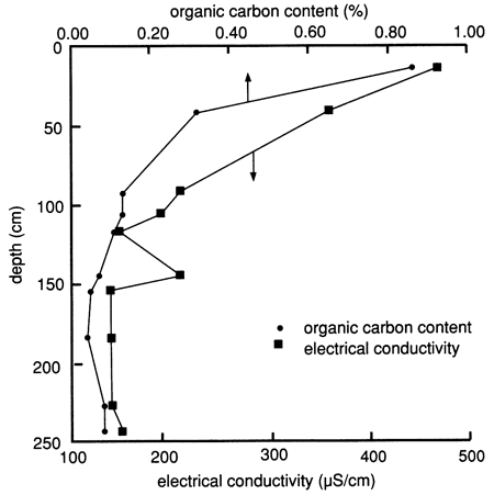
The specific soil horizons and their grain-size distribution (texture), as determined by the SCS, are shown in fig. 56. The sand fraction dominates throughout the profile, and the clay and silt fractions are only minor components of the soil. The organic carbon content of the soil is low, indicating that the soil does not have much potential for retention of chemicals (fig. 57). The electrical conductance for the soil profile is also low, indicating that no appreciable concentration of salts has occurred.
Figure 56--Grain-size distribution and soil horizons for site 10.
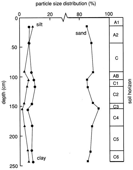
Figure 57--Organic carbon content and electrical conductivity for site 10.
Water chemistry
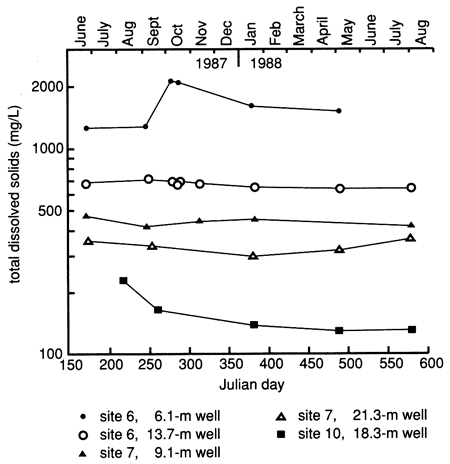
The water chemistry at site 10 plots on the trilinear diagram as a CA-HCO3 water (fig. 58). This is to be expected because the ions in the water come from the leaching of silts and sands by precipitation water without appreciable evaporative concentration. The specific conductance and total dissolved solids content for waters from this site are low in comparison with sites 6 and 7 (fig. 59). The wells that were measured at site 10 are 18.3 m and 19.8 m (60 ft and 65 ft) deep. Comparison of the total dissolved solids content of these wells (fig. 59) with that of both the shallow and deep wells from the other sites shows the impact that continuous irrigation has on the general water quality at sites 6 and 7. All the wells at sites 6 and 7 showed much higher total dissolved solids values throughout the period of study. These higher concentrations illustrate the concentrating effects that evapotranspiration has on salt in the upper soil zones. The water chemistry data from this site are tabulated in table C.3.
Figure 58--Trilinear diagram showing water chemistry data for three wells at site 10. Numbers next to points indicate depths (in feet).
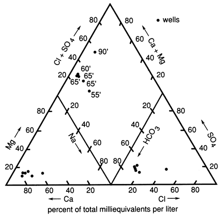
Figure 59--Time-series distribution of total dissolved solids for the shallowest and the deepest observation wells at sites 6 and 7 and for the shallow observation well at site 10.
Prev Page--Site 7 || Next Page--Conclusions
Kansas Geological Survey, Geohydrology
Placed on web Aug. 23, 2010; originally published 1990.
Comments to webadmin@kgs.ku.edu
The URL for this page is http://www.kgs.ku.edu/Publications/Bulletins/GW12/06_site10.html