![]()
Prev Page--Paleontology--Illinoian and Wisconsinan || Next Page--Bibliography
Summary of Pleistocene Drainage Changes
The present stream pattern of Kansas has evolved almost entirely as a result of events during Pleistocene time. However, in order to view in proper perspective this relatively short interval of rapid evolution of the present drainage, we should look farther back into the geologic record.
The earliest drainage that has a bearing on present stream patterns is that which existed on the early Cretaceous erosion surface. This surface in central and eastern Kansas beveled Pennsylvanian and Permian rocks. It was a surface of moderate relief and in central Kansas it is preserved along a northeasterly trend by progressively overlapping Cheyenne sandstone, Kiowa shale, and Dakota formation. The contact of Cretaceous on Permian is exposed in a belt extending from Comanche County on the Oklahoma state line to Washington County on the Nebraska state line. At many localities the basal few feet of Cretaceous rocks contains pebbles and cobbles of a size and type unknown in the remainder of the Kansas Cretaceous section. These pebbles are genetically related to the erosion surface rather than to any stratigraphic position within the Cretaceous as indicated by the fact that they are found only adjacent to the unconformable surface. They occur in the Cheyenne, Kiowa, and Dakota where each of these units is in contact with pre-Cretaceous rocks, but are never found in the Dakota or Kiowa where these units are underlain respectively by Kiowa and Cheyenne.
The pebbles and cobbles found above the pre-Cretaceous erosion surface are well rounded, smooth, and in size are as much as 4.5 inches in maximum diameter. They consist predominantly of chert, quartz, and quartzite, and siliceous cemented quartz sandstone. In two chert pebbles from Rice County in central Kansas fusulines have been identified by M. L. Thompson (personal communication) who states that the particular species are known to occur only in lower Permian limestones more than 100 miles farther east in Kansas. The occurrence of eastern fusulines is association with metamorphic rocks strongly suggests a source to the northeast, thus establishing the direction of major drainage in early Cretaceous time as southwesterly across eastern and central Kansas.
The alignment of lenticular sand bodies in the Dakota formation confirms this interpretation. Channel sands display a general southwest-northeast trend whereas beach and bar sands are commonly at right angles to this trend (Norman Plummer, personal communication).
Late Tertiary Drainage
There is no direct evidence to indicate whether or not drainage lines extended themselves as consequents across the Cretaceous sediments and thus returned to a southwesterly trend as Cretaceous seas withdrew. Data bearing on this point have been removed by erosion. However, strong evidence indicates that, in any event, such a trend was not in existence in late Tertiary time. In central and western Kansas Pliocene sediments of the widespread Ogallala formation are composed of coarse clastic materials derived predominantly from a western source in the Rocky Mountain region and from local bedrock. In marked contrast to the lithology of the Ogallala formation, the late Tertiary sediments in the eastern one-fourth of Kansas are entirely attributable to the Permian and Pennsylvanian rocks eastward from and including the Herington limestone.
The fact that the locally derived high level chert gravels in eastern Kansas are Tertiary in age is demonstrated by their physiographic position. A prominent terrace occurring about 40 feet above the present flood plain has been studied along much of the Cottonwood-Neosho River Valley by H. G. O'Connor. This terrace has been dated as Kansan by petrographically distinctive Pearlette volcanic ash (Frye, Swineford, and Leonard, 1948) contained in the sediments at Emporia. Also, vertebrate fossils from the same level in Lyon County have been examined by R. W. Wilson. Remnants of a distinct chert gravel veneered terrace that may be Nebraskan in age occur along the same valley system at a level 80 to 100 feet above the present flood plain. Other chert gravels occur at several higher positions and in Coffey, Anderson, and Alien counties they cap divide areas at elevations as much as 300 feet above the same reference flood plain level. Above the Emporia (40-foot) terrace all surficial deposits are severely weathered throughout their thickness. They consist only of chert (of types characteristic of the Herington and stratigraphically lower limestones) in a reddish clay matrix, and therefore their dating rests solely on their physiographic position.
The high level gravels at positions as much as 300 feet above flood plain level and judged to be pre-Pleistocene because as much as 200 feet of bedrock incision occurred after their deposition and prior to the deposition of Nebraskan terrace gravels. The high level gravels are considered to be late Tertiary in age because Cretaceous sediments which approached or overlapped the western part of the Flint Hills region were removed and the resistant cherty Florence, Fort Riley, and adjacent limestones were etched into strong relief prior to the deposition of these high level gravels. No stream-rounded chert gravels occur on the crest of the Flint Hills even though broad gently sloping surfaces are common. These relationships show that some time during the Tertiary the Flint Hills became a major divide separating two strongly contrasting depositional provinces. The western of these two provinces discharged drainage southward from Kansas into Oklahoma, and the eastern province discharged its drainage eastward into Missouri.
Although data on the pre-Pleistocene history north of Kansas River Valley are obscured by glacial deposits a similar erosional history is known to have obtained. Detailed studies of pebble lithologies by Davis (1951) show that even along the Kansas River Valley, now the only valley carrying western drainage through the Flint Hills, western materials were not deposited until after the Kansan glacial age and that the late Tertiary drainage pattern was similar to that farther south.
Details of the pre-Pleistocene drainage are not known but the regional distribution of Pliocene sediments, Ogallala stratigraphy, and lithologies of clastic sediments show clearly that streams flowing toward the east or southeast from the Rocky Mountain region crossed western and central Kansas and left the State toward the south. The early Pliocene drainage was localized in valleys in an erosional topography of gentle slopes but with divides as much as 300 to 400 feet above the major valley floors. This is attested by the stratigraphic overlap of the several members of the Ogallala on the former bedrock surface. As alluviation proceeded through Pliocene time these erosional valleys were filled so that the resulting plains of alluviation generally coalesced over the former divides. Thin deposits of uppermost Ogallala are relatively common along the crest of the Greenhorn limestone (Cretaceous) cuesta showing that this present scarp-forming formation, as well as the Fort Hays limestone, exerted little influence on regional topography by the end of Ogallala deposition.
However, late Tertiary drainage that flowed eastward from the Flint Hills crest was much less effective in obliterating the bedrock topography as the deposits of these streams were restricted to valley bottoms. Thin chert gravel deposits at several levels above the terrace presumed to be Nebraskan in age indicate that the late Pliocene topography of eastern Kansas was essentially erosional on the Paleozoic bedrock with a maximum local relief of less than 200 feet and that the major valleys were flanked by two or perhaps more terraces thinly veneered with chert gravels.
Nebraskan Drainage
As the Nebraskan glacier started to accumulate, Kansas was a region of subdued topography and with much less relief than that existing at the present time. The western third of the State was an extensive alluvial plain with perhaps a few low gently rounded divides underlain immediately by Cretaceous rocks. This surface was not without character, however, as such a plain developed by laterally shifting depositing streams must have displayed features such as natural levees, abandoned channel segments, and intra-channel "backswamp" areas typical of surfaces built by stream deposition. The water table under this surface must have been quite shallow (as it now is under parts of the Arkansas River alluvial plain) and standing bodies of water must have occurred in disconnected low places.
If this surface were warped along an east-west axis in northwestern Kansas, and tilted gently toward the east, as suggested by Smith (1940), drainage of essentially a consequent origin may have developed and so given rise to a semi-radial stream pattern in northwestern Kansas. This conclusion is strengthened by the fact that northwestern Kansas was never crossed by a major through-flowing stream during Pleistocene time.
In central Kansas, this western alluvial plain merged laterally with an erosional plain of almost equally subdued relief. In central Kansas broad alluviated valleys were joined by alluviated tributaries which were filled to shallow depths with locally derived materials. A major stream flowed south across central Kansas (Fig. 12) parallel to the strike of the bedrock, in a belt of shales which occur at the foot of the long dip slope west of the Flint Hills.
Figure 12--Reconstructed major drainage lines in Kansas in late Nebraskan time. Dashed line is maximum extent of Nebraskan glacier. Names refer to abandoned valley segments.
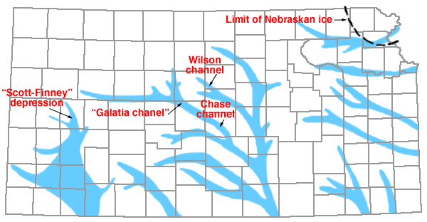
Deepening of all major stream channels occurred generally in Kansas at about the beginning of the Pleistocene. The depth of this incision ranged widely in different places. For example, in the filled Chase channel in central Rice County described by Fent (1950), late Nebraskan sediments are the lowest part of the fill of a valley cut 200 feet below thin Ogallala on adjacent uplands; in eastern Ellis County Nebraskan stream sediments occur about 150 feet below Ogallala beds capping the adjacent Fort Hays limestone scarp (A. R. Leonard and D. W. Berry, in preparation); in the northwestern corner of Ness County a remnant of a Nebraskan terrace is less than 75 feet below the Ogallala; while along Cimarron River Valley in southwestern Kansas and in north-central McPherson County Nebraskan stream sediments rest on eroded Ogallala formation.
In the glaciated area Nebraskan deposits are obscured except along the Missouri River Valley in Doniphan and northern Atchison counties. In that area David City (Nebraskan) sand and gravel occur below Nebraska till and rest on Pennsylvanian bedrock about 35 feet above the flood plain of Missouri River (Frye and A. B. Leonard, 1949), whereas in the same area chert gravels overlain by glacial deposits and judged to be pre-Nebraskan in age occur 25 to 50 feet higher above the same datum. These data also indicate moderate bedrock incision during earliest Pleistocene time.
The cause of this early Pleistocene stream incision is not known. It can hardly be attributed to lowering of sea level because most of the downcutting was accomplished by the time the Nebraskan ice had reached its maximum extent; furthermore the maximum depths of downcuttings in Kansas were in the central area. Neither is crustal warping alone an adequate explanation. The maximum unwarping of the late Pliocene surface was in the northwestern part of the State (Smith, 1940) and that area contains the least evidence of marked early Pleistocene valley deepening. Although several factors probably contributed to the early Pleistocene downcutting, the principal causes are judged to be changes in stream regimen--that is, the relation of volume to load--and generally accentuated gradients produced by regional eastward tilting.
The inferred reconstruction of the late Nebraskan drainage is shown on the map in Figure 12. Much of the reconstruction of this drainage pattern is based on subsurface data obtained in the course of test drilling by the cooperative State and Federal Geological Surveys' Ground-Water Division (Fent, 1950, 1950a; Frye and Walters, 1950). Other parts of the pattern are based on terrace remnants and on projections from known deposits (e.g., Sumner County). Along the Smoky Hill Valley in Gove, Ness, and Trego counties remnants of a Nebraskan terrace have been observed and studied in detail in the vicinity of Antonino in Ellis County (A. R. Leonard and D. W. Berry, in preparation). Another arm of this late Nebraskan system is represented by alluvial deposits in east-central Ellis County and near Galacia in northwestern Barton County (Latta, 1950) where a stream crossed the present divide separating Smoky Hill from Arkansas drainage. From the "Galatia channel" the stream flowed southeastward through Chase channel across Rice County and joined the north-south master stream in Sedgwick County.
In southwestern Kansas another major north-south drainage line extended south through the Scott-Finney depression (Waite, 1947) and seemingly spread laterally to alluviate an extensive basin lying west of the Crooked Creek and Fowler faults (Frye, 1942) in central Meade County. In strong contrast to the present drainage pattern the general grain of the Nebraskan drainage of southern and central Kansas was north-northwest to south-southeast. As the Nebraskan glacier entered only the northeastern corner of the State, it was presumably served by an eastern spillway along its southern limit defined by test drilling (Frye and Walters, 1950), and now buried under Kansas till. Outwash of Nebraskan continental glaciers does not occur beyond the limits of Kansan glaciation (Davis, 1951).
Kansan Drainage
Events directly and indirectly related to Kansan glaciation initiated the sequence of drainage adjustments, perhaps still in progress, that gave rise to the present stream systems of the State. Kansan ice entered Kansas from the northeast but advanced well beyond the limit of Nebraskan glaciation, overrode the Flint Hills upland into Washington County, and covered important parts of this earlier divide in Marshall and Pottawatomie counties. The western and southern extremities of the Kansan glacier produced the eventual integration of the Kansas River system.
The stream pattern at the beginning of Kansan time is judged to have been similar to that of late Nebraskan time. During the advancing phase of Kansan glaciation Kansas streams generally deepened their channels; the prominent valley across southern Nemaha and northern Jackson counties was deepened and then alluviated with pro-Kansan (Atchison formation) sands, and eventually overridden by the ice. Locally the Kansan glacier extended across the position of the Kansas River Valley and forced meltwaters into a temporary spillway to the east along Wakarusa Valley (Todd, 1911). This spillway, however, was not available to the meltwaters from the western edge of the lobe because it was effectively blocked by the ice mass itself. Available evidence indicates that the only avenue of escape for the meltwaters and outwash from the Washington and Marshall County area was toward the southwest and thence southward along the line of the formerly well-established drainageway across Saline, McPherson, Harvey, and Sedgwick counties. Such a spillway course reversed the direction of flow through the headwaters of an "ancestral Kaw Valley" in the Flint Hills area and spilled into the headwaters of a tributary to the major south-flowing stream through central Kansas. At least two other important spillways, later abandoned, carried meltwater and outwash westward from the western margin of the Kansan glacier in Kansas (Fig. 13). These temporary drainage lines originated along the ice margin where it extended west of the Flint Hills divide and as they were heavily alluviated and soon abandoned they had little influence on the future stream pattern. The spillway westward along the present course of the Smoky Hill Valley past Junction City, however, had a profound effect on later drainage as the temporarily large volume of water and sediment deeply notched the major divide and provided the mechanism for the integration of the present Kansas River system.
Figure 13--Reconstructed major drainage lines in Kansas in late Kansan time. Arrows and numbers refer to direction and position of stream flow during early stage of Kansan glacial retreat (1), and during latest statge of Kansan retreat, or during early Yarmouthian time (2). Dashed line is maximum limit of Kansan glacier. Names refer to abandoned valley segments.
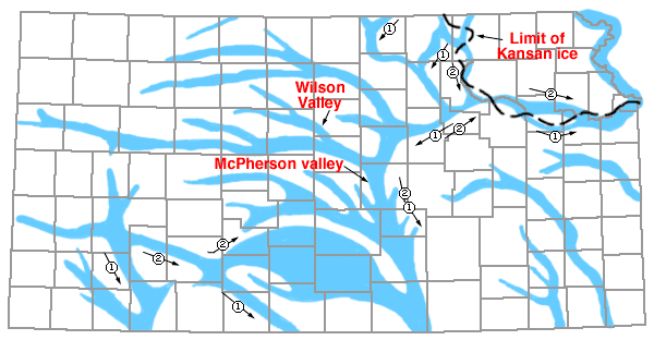
Evidence for this western spillway is fragmentary but nevertheless quite strong. Regional examination of chert gravels and physiography in eastern Kansas, and particularly studies of pebble lithology by Davis (1951) along the Kansas River Valley, show that drainage from west of the Flint Hills did not come east across the divide until after retreat of the Kansan glacier. Outwash sand and gravel on bedrock occur high above the valley flat of the Smoky Hill River west of Junction City, and the former McPherson valley across McPherson County is filled to a depth of 150 feet with sand, gravel, and silt dated as late Kansan in age by more than a half dozen localities of Pearlette volcanic ash. The late Kansan drainage through McPherson valley is known to have been southward because of the gradients of bedrock floors and its integration with the drainage pattern demonstrated by extensive terrace deposits along Smoky Hill Valley, abandoned Wilson valley, and widespread test drilling.
Present elevations do not indicate a gradient from the Flint Hills area toward the McPherson channel as the bedrock floor under the Kansan stream sediments in that abandoned valley is as high, or higher, than the level of the outwash deposits west of Junction City. This is the expectable relationship if the drainage history is as shown in Figure 13. The Smoky Hill Valley spillway toward the west was in use at the time of the Kansan glacial maximum and it is safe to infer that isostatic adjustments to this ice mass--the greatest to invade the midwest--were at least as great as those that have been determined to have been associated with late Wisconsinan glaciers (Flint, 1947, pp. 409-427). The area where this spillway crossed the crest of the Flint Hills is within 25 miles of the glacial margin and should have had maximum effect of the marginal isostatic bulge, whereas the McPherson channel is more than 100 miles from the nearest point along the ice front and may have been beyond the effects of superelevation. As 100 feet of temporary elevation is indeed a conservative figure for the marginal zone of a glacial mass as large as the Kansan, a temporarily adequate gradient toward the south undoubtedly existed during the time southern drainage occurred.
It is well known that deep incisions have been made in glacial spillways in relatively short periods. Such an incision along the course of the present Smoky Hill produced a channel that, when lowered by isostatic adjustment due to the retreat of the Kansan ice mass, allowed the establishment of a competent eastward-flowing stream through the Flint Hills. This eastward-flowing stream, reversed the direction of flow through the temporary spillway.
The fact that most of the fill of McPherson channel was contributed from the northeast (Lohman and Frye, 1940) as Kansan outwash is demonstrated by quantitative relations. McPherson valley, which is 4 to 5 miles wide, contains in its deepest part more than 100 feet of sand and gravel overlain by more than 50 feet of sand, silt, and volcanic ash. The principal western tributary to this channel was the ancestral Smoky Hill and its large tributary through the abandoned Wilson valley (Fig. 13). The Kansan terrace fill has been studied westward along more than 200 miles of Smoky Hill Valley. Here the Kansan sediments fill a narrow channel which in the western part of the State averages less than one-fourth mile in width and the sand and gravel fill only about 25 feet in thickness. East of the junction of the Wilson valley channel the Grand Island (Kansan) gravels are somewhat thicker and wider but even here, insignificant in comparison to the imposing quantity of material in abandoned McPherson valley. It is significant that westward along the Smoky Hill Valley the Crete (Illinoian) gravels that overlie the Grand Island-Sappa (Kansan) are quantitatively more extensive. These facts emphasize the importance of northern and northeastern sources in the filling of abandoned McPherson valley.
Kansan outwash moved across Kansas not only from the continental glacier in the northeastern corner of the State but also from the Rocky Mountain region to the west. That Rocky Mountain outwash did not come down the Smoky Hill Valley is indicated by the relative insignificance of the Grand Island gravels, previously described. However, a vast quantity of Grand Island gravels attaining thicknesses as much as 100 feet and overlain by Sappa silts that locally contain Pearlette volcanic ash and characteristic molluscan faunas occurs in south-central Kansas. The quantity of Kansan gravels in this region is entirely too great to have been derived from the relatively thin and commonly finer textured Ogallala that is adjacent to it. The only explanation that adequately accounts for such a quantity of coarse-textured arkosic material of known Kansan age is the assumption that Arkansas River was integrated to approximately its present course across western Kansas eastward to the region of the great bend during Kansan time. This integration probably took place on the surface of the rapidly accumulating alluvial fill. Some drainage in Kansan time went southward through the area of important Nebraskan drainage in Gray and Meade counties, but in this area the Kansan sediments are predominantly silts, clays, and fine sands, and such coarse gravels as do occur are relatively thin and not widespread. This suggests that the principal drainage line along the course of the Arkansas alluviated sufficiently to spill over a low divide and continue eastward, thus allowing the accumulation of fine-textured local materials and large quantities of Pearlette volcanic ash in the slackened waters of a former major drainage-way (Fig. 13) southward across Meade County.
The same process was probably repeated in southeastern Ford County depriving a former major valleyway across Comanche County of further western sediments after the first influx of Kansan outwash. Thus the later stages of Rocky Mountain outwash moving down the Arkansas Valley were carried eastward to join near the Oklahoma state line with the major outwash spillway from the continental glacier to the northeast. In much of northern Kiowa, southern Edwards, Stafford, Reno, northern Barber and Harper, and nearly all Pratt and Kingman counties, Kansan outwash gravels (Grand Island member, Meade formation) form an almost coalescent sheet. In most of these counties the surficial deposits have been test drilled extensively by the State and Federal Geological Surveys' Ground-Water Division and details of this drilling are reported in the respective county bulletins. Throughout this region there is no indication of structural or stratigraphic control--in fact quite the opposite is the case as the bedrock beneath these sediments (where they do not rest on older Nebraskan alluvium) is relatively nonresistant beds of Cretaceous and Permian age. The most logical explanation seems to be that in a region of lessened gradient heavily outwash-laden streams repeatedly shifted their courses on the surface of their own alluvial fills and locally may have developed distributary systems. Progressive shifting toward the east was probably assisted by regional eastward tilt judged to have accompanied the early Pleistocene uplift of the Rocky Mountain region.
During late stages of Kansan glacial retreat Arkansas River maintained an easterly course. However, profound changes occurred in the stream pattern or northeastern Kansas. The temporary spillway along Wakarusa Valley was abandoned and drainage was permanently established eastward along the Kaw Valley. Missouri River took its present course across the Kansas till plain, probably influenced locally by sags in the till plain surface over earlier Nebraskan valleys. Spillways across Republic and Washington counties were abandoned and a major stream was formed, in part on the till plain surface and in part by integration of spillway channels, in the present position of Blue River. The most important modification, however, was along the Smoky Hill Valley westward from Junction City. As isostatic adjustment is judged to proceed more slowly than unloading by glacial retreat, the channel cut by westward-flowing meltwater probably remained high long after the Kaw Valley was freed from ice and Missouri River carried the drainage eastward from the formerly glaciated area of Kansas. At this stage a divide probably existed on the floor of this former spillway in the vicinity of Junction City or somewhat west of that point, drainage west of the divide continued southwest through McPherson channel, and that east of the divide became a part of Missouri River drainage. As the former marginal bulge subsided this divide shifted westward and progressively more of the former tributaries to McPherson valley became integrated with Kansas-Missouri River drainage. This progressive diversion or "piracy" had a double effect; by decreasing the available volume of water through the already heavily alluviated McPherson valley it allowed still further accumulation of finer sediments in that area while promoting valley incision to the east in the Kaw Valley. Just how fast this divide shifted toward the west is not known, but the evidence indicates that by late Illinoian time the divide was located south of Salina and north of Lindsborg and that Saline River flowed eastward through the Kaw Valley to Missouri River while the upper Smoky Hill continued to flow southward through the McPherson channel.
Illinoian Drainage
Illinoian and later stream patterns in Kansas have been controlled primarily by a continuation of adjustments to the events associated with Kansan glaciation. The progressive southward shifting of the divide along the Smoky Hill spillway had reached southern Saline County by Illinoian time. This is attested by the facts that Crete (Illinoian) gravels consistently overlie Kansan sediments in the terraces along Smoky Hill Valley westward and through the now-abandoned McPherson valley southward (O. S. Fent, personal communication), showing that the Illinoian drainage along the Smoky Hill from the west followed--without incision--the same course as the Kansan drainage (Fig. 14). In Saline Valley, a Crete (Illinoian) terrace occurs more than 100 feet below the bedrock floor of the dissected north end of Wilson valley. The now abandoned Wilson valley, which carried a Kansan tributary to the Smoky Hill across the present Saline-Smoky Hill divide, preserves a thick fill of Kansan sediments dated both by Pearlette volcanic ash and faunas. This relationship demonstrates clearly that by late Illinoian time all drainage in the region from the Saline to the Republican had become part of the Kansas River system, and as evidence along the Kansas River Valley (Davis and Carlson, 1952) shows that the bedrock floor of the Illinoian valley was cut more than 90 feet below the bedrock floor of the Kansan terrace deposits, all these northern valleys display a normal terraced or physiographic sequence--i.e., the succeedingly younger deposits occur on succeedingly lower terraces, which is not true in the south-central and southwestern valleys. The terraces along some of these northern valleys, particularly the Solomon (A. R. Leonard, 1952) and Prairie Dog (Frye and A. R. Leonard, 1949), have been studied in detail.
Figure 14--Reconstructed major drainage lines in Kansas in late Illinoian time. Name refers to abandoned valley segment.
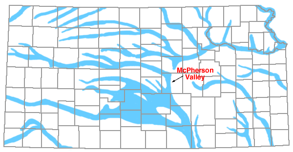
Although the direct evidence is inconclusive it seems probable that McPherson valley was finally abandoned by through-flowing drainage in late Illinoian time as the added fill of Crete gravels perched this stream well above the eastern drainage lines adjacent to the north, and the low divide on the former spillway valley floor would have presented little obstruction to such an adjustment.
In south-central and southwestern Kansas the Illinoian drainage was closely similar to the latest Kansan pattern. The formerly important stream course southward through the "Scott-Finney depression" and on across Gray and Meade counties was finally abandoned as was major drainage southeastward from Ford County across Comanche County. Arkansas River was established along its present course as far east as Kiowa County, and eastward in the region south of the great bend the Illinoian channels again shifted laterally spreading an extensive sheet of coarse alluvium. Judging from the present distribution of Crete gravels the Illinoian channels shifted less extensively than did the Kansan channels and the principal drainageways were farther north. The present course of Arkansas River may have been established by laterally shifting channels in this region during late Illinoian time. Early Wisconsinan terraces occur along some stream valleys incised through the Crete gravels and show that the Arkansas was near its present position by early Wisconsinan time.
In eastern Kansas south of the Kaw Valley there is little evidence of important stream action during Illinoian time. The prominent Emporia terrace of late Kansan age extends along the Cottonwood-Neosho at an average height of about 40 feet above the present flood plain but a prominent lower terrace does not exist except as a part of the flood plain complex.
Wisconsinan Drainage
In northern Kansas the Wisconsinan drainage was closely similar to the Illinoian (Fig. 15). Bedrock floors below the Wisconsinan terrace sediments show that some valley cutting occurred after development of the Crete (Illinoian) terraces (Frye and A. R. Leonard, 1949; A. R. Leonard, 1952; Davis and Carlson, 1952) but that the position of valleys remained fixed. If the northward diversion of the Smoky Hill to join the Saline at Salina did not take place in latest Illinoian time on the surface of the Crete fill, it certainly had occurred by Iowan time as shown by the position of Peoria loess through this part of the valley and by the deeper bedrock incision of the Wisconsinan Smoky Hill below the Crete terrace as compared with the other valleys of the Kansas River system to the north.
Figure 15--Major drainage lines in Kansas in Wisconsinan time. Names are of principal rivers.
Along the valleys of the region south of Kaw Valley and east of the Flint Hills the Wisconsinan sediments are included entirely within the flood plain complex.
It is in south-central Kansas that the Wisconsinan drainage presents the most striking contrast to the Illinoian pattern. Arkansas River became integrated on the surface of the Illinoian alluvial plain, perhaps in latest Illinoian time, and certainly by early Wisconsinan time and has undergone slight modification since. However, the streams draining the region southward from Kiowa, Pratt, and Kingman counties, have been importantly modified since the close of Illinoian alluviation. Most valleys in this region are flanked by low terraces at two distinct levels that have been dated at many placed by molluscan faunas as early and late Wisconsinan. These well-developed terraces show that the streams of this area preserve in the main the early Wisconsinan drainage pattern, but that this pattern differs radically from the Illinoian drainage and is incised deeply below it. Perhaps the maximum deepening occurred in Barber County where the level of Crete alluvium is the upland plain to the north and the level of the Wisconsinan terraces in the central part of the county is 300 feet lower (Pl. 2). The valleys of Chikaskia and Ninnescah Rivers and Slate Creek to the east and Salt Fork River and Kiger and Bluff Creeks to the west were all incised a lesser amount. Crooked Creek in southern Meade County took its present course by the integration of several solution-subsidence basins and a depressional area along the Crooked Creek fault. Cimarron River across southern Clark and Comanche counties integrated drainage from formerly isolated solution-subsidence areas, and this valley was deepened westward across the State.
Inconclusive evidence suggests an important diversion in southwestern Cowley County. Here the alluviated surface, well below the level of Kansan sediments that occur immediately adjacent to the west, extends southward into Oklahoma from the point where Arkansas River turns sharply eastward (Fig. 15). As the present Arkansas Valley is sharply constricted between bedrock bluffs east and south from this point, and as Walnut River swings sharply west to its juncture with the Arkansas, it seems likely that the Arkansas was diverted to the rapidly downcutting Walnut on the surface of its alluvial plain. Although this diversion could have occurred as early as Illinoian time it seems more likely from regional relationships to have happened during early Wisconsinan time.
The present drainage pattern of Kansas, although internally anomalous, is fairly well stabilized. Further diversion of Arkansas tributaries to the Kansas River basin seems effectively barred by the breadth and character of the present Smoky Hill-Arkansas divide in spite of the discrepancy in altitude and regimen of the two streams. The Arkansas has been consistently alluviated throughout late Pleistocene time and as its tributaries heading south of it have been eroding during much of this time the Arkansas channel is perched with respect to adjacent drainage (Pl. 2A, 2B). Although diversions may eventually result from this unbalanced condition the existing divide areas are of sufficient breadth to protect present drainageways for an indefinite period of time.
The regional implications of Kansas drainage history as outlined are not clear. Existing Kansas streams flow toward the south and east and as detailed studies of Pleistocene drainage have not been made in Missouri or Oklahoma, it is impossible to know the correlation of the history reconstructed for Kansas with these downstream areas. It is not known that major drainage entered northern Kansas from the Nebraska region during early Pleistocene time and therefore an important east-west divide may have existed in northern Kansas or southern Nebraska. If this were the case the headwaters of southern drainage were located in northern Kansas' and the region to the north drained eastward and northward as was suggested many years ago by Todd (1914).
The progressive eastward shift of Kansas drainage throughout Pleistocene time resulted in progressively more western drainage entering the central Mississippi Valley. Oklahoma is a region replete with drainage problems. As early Pleistocene drainage, including sizable quantities of outwash, left Kansas to the south, and as the present valley of Arkansas River across Arkansas does not present the appearance of having earlier carried a much greater volume of water--in contrast to the Red River Valley which is flanked by broad alluvial terraces--one may speculate that future work in Oklahoma will reveal abandoned stream courses from the north that carried drainage southward into Red River Valley.
The Kansas Landscape
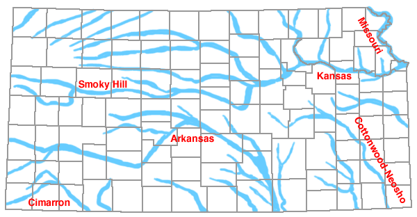
The Kansas landscape is the most ever-present product of geological processes operating during Pleistocene time. The plains and prairies of Kansas, although they do not possess strong relief, display striking contrasts among the several regions of the State (Pl. 19; Figs. 16, 17). Each of these several regions displays some distinguishing internal features of topography and they approximately coincide with the several geologic and climatic regions of the State. The surface of Kansas in general slopes upward from elevations of 700 to 1,000 feet above sea level in the east and southeast to elevations exceeding 4,000 feet in the west near the Colorado state line. The rainfall belts also show a gradation from east to west with the normal rainfall being more than 40 inches per year in the southeast and 15 to 20 inches per year in the west. The pre-Pleistocene areal geology changes from Pennsylvanian and Permian rocks in the east, through Cretaceous rocks in the central region, to Pliocene rocks in the western region. The several physiographic, or topographic, provinces of Kansas are also general north-south belts that change in character toward the west.
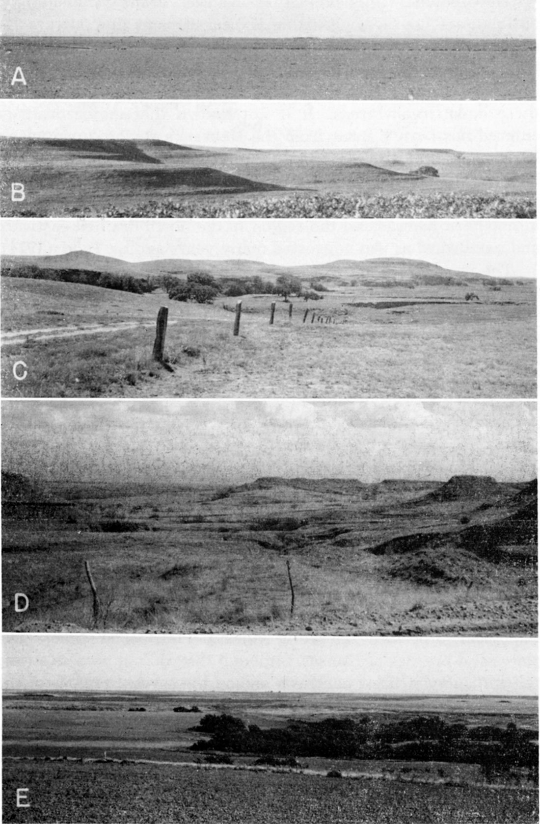
Plate 19--Kansas landscape. A, High Plains surface, central Lane County. The surface is a thin cover of eolian silt and sand on Ogallala formation (1946). B, Flint Hills Upland in sec. 8, T. 31 S., R. 8 E., Cowley County. Surface cut in Permian cherty limestones and shales (1950). C, Smoky Hills topography in sandstones, shales, and siltstones of Dakota formation, east-central Russell County (Norman Plummer, 1940). D, Red Hills topography in Permian red shales and siltstones and gypsum; central Barber County. The flanking pediment slopes developed in late Pleistocene time, dissected by younger erosion. The resistant caprocks are gypsum beds (S. W. Lohman, 1939). E, High Plains near Nebraska state line in Norton County. Late Pleistocene loess mantle on Ogallala formation, on Cretaceous chalky shale (1946).
In order to discuss these physiographic regions it is necessary to assign names to them. Fenneman (1931), in his map of the physiographic subdivisions of the United States, placed eastern Kansas in the Central Lowlands province and western Kansas in the Great Plains province. He further subdivided the Central Lowlands of the State into the Dissected Till Plains section (roughly the area north of Kansas River Valley) and the Osage Plains, and in the Great Plains province he recognized the Plains Border section in central Kansas and the High Plains section in the far west. Other schemes of physiographic subdivision have been discussed by Adams (1903), Frye (1946a), Frye and Swineford (1949), and Schoewe (1949). In the following discussions (Fig. 16) Adams' (1903) usage (also, Frye and Swineford, 1949; Schoewe, 1949) of High Plains, Red Hills, Flint Hills Upland, Osage (Prairie) Cuesta Plains, and Cherokee Plain are adopted. "Dissected Till Plains" is retained for the northeastern glaciated area, "Great Bend Region" is applied to the extensive sand dune tract and associated territory in the central part of the State, and "Smoky Hills" is used as defined by Adams (1903). The Arkansas River alluvial plain, which lies adjacent to the Wellington Area, is of sufficient size to merit special notice in part of central Kansas.
Figure 16--Physiographic regions of Kansas. These generalized regions of internal topographic homogeneity are modified from Adams (1903) and Schoewe (1949). Small letters show location of photographs on Plate 13 and large letters show location of photographs on Plate 19. [For a modern version, please see the Survey's Physiographic Map of Kansas.]
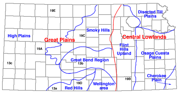
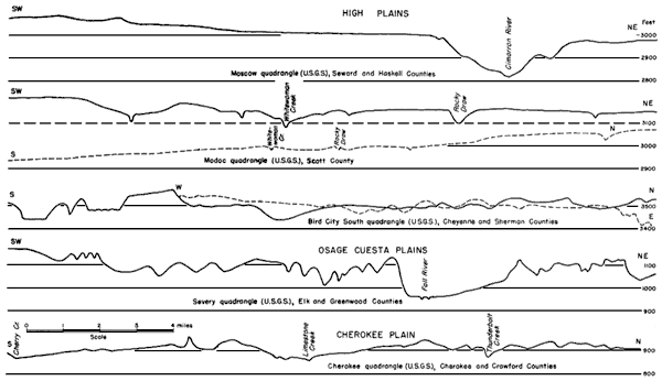
Figure 17--Surface profiles in High Plains, Osage Cuesta Plains, and Cherokee Plain. Profiles plotted from U.S. Geological Survey quadrangles of the 15-minute series. Adequate maps are not available to illustrate the topography of the other physiographic subdivisions of the State. A larger version of this figure is available.
The High Plains (Frye, 1946a) include approximately one third of the area of Kansas; they occur in the western part of the State and extend into contiguous parts of Oklahoma, Colorado, and Nebraska. The High Plains constitute a plateau bounded by distinct scarps on the east and west. Their eastern limit is defined by the prominent scarp of the Fort Hays limestone (Niobrara formation, Cretaceous) for 150 miles northeastward from Finney County and by scarps formed by Ogallala formation overlying relatively nonresistant Cretaceous and Permian rocks southward from northern Clark County to the Oklahoma state line. In the vicinity of Arkansas River Valley a distinct eastern boundary does not exist.
The topography of the broad interfluves in the High Plains section is monotonously regular (Pl. 19A, 19E) with a regional eastward slope of about 10 feet to the mile. In much of the region the surface is underlain by late Pleistocene loess and locally by eolian sand resting on earlier Pleistocene deposits or Pliocene Ogallala formation. However, in the northern tier of counties, the loess mantle transgresses without noticeable topographic break onto the eroded surface of Cretaceous chalky shales and extends to the crest of the Fort Hays limestone escarpment. Much of the High Plains upland surface is not drained by integrated surface channels, and two sizable drainage systems (Whitewoman Creek and Bear Creek) are not integrated with any through-flowing stream.
Arkansas River is the only Kansas stream that completely crosses the High Plains region from a source jin the Rocky Mountains but its level is only slightly below the upland surface (Pl. 2). In striking contrast, Smoky Hill River, which originates on the plains surface in Colorado, occupies a valley 15 to 20 miles wide cut in Cretaceous bedrock. The Smoky Hill River Valley is characterized by a series of sweeping flanking pediments thinly veneered with colluvium and loess (Fig. 4). The Cimarron River Valley, to the south of Arkansas River, is also cut well below the level of the Arkansas (Pl. 2) and is characterized by flanking pediments (Frye and Smith, 1942), as are Pawnee River and Walnut Creek, tributaries to the Arkansas from the north. The valleys adjacent to Nebraska lack well-developed flanking pediments but contain a sequence of alluvial terraces.
In spite of the general monotony of High Plains topography it possesses distinctive and almost unique features. The major valleys, with the exception of the Arkansas, slash the upland surface abruptly, and the upland surface is marked by many thousand depressions of various sizes. These depressions have attracted the notice of geologists for more than half a century (Haworth, 1897a; Johnson, 1901; Darton, 1905; Smith, 1940; Frye and Schoff, 1942; Evans and Meade, 1945; Frye, 1950) and have been attributed to many causes including the wallowing of buffalo, solution-subsidence, wind scour, differential eolian deposition, differential compaction, and silt infiltration. Most, if not all these processes have had a share in the development of High Plains depressions (Frye, 1950), but the most important factor permitting the widespread development and preservation of surface depressions is the general absence in this region of processes that tend to inhibit or destroy such features. Erosion by lateral stream planation is effective in a very small part of the region and, as much of the upland surface lacks integrated surface drainage, erosion along defined stream channels is small. Pedimentation has been important in shaping the major valleys and only solution-subsidence depressions have been observed on the flanking pediment surfaces. On the flat uplands, even sheet erosion is of relatively small importance and the persistent mantle of eolian silt is subject to shifting during periods of excessive drought. Evidence from the stratigraphy of the loesses and buried soils shows that the majority of High Plains depressions developed during late Pleistocene time.
The Red Hills (Pl. 19D) in the south-central area exhibit some of the most rugged and striking topography in Kansas. The strong red color of the exposed Permian bedrocks makes the section a scenic attraction. The Red Hills are essentially the belt of dissected terrain associated with the retreating scarps of the High Plains. In this area the Ogallala formation (Clark County) and early Pleistocene deposits (Comanche, Barber, and Kingman counties) cap the westernmost scarp which defines the edge of the High Plains, but resistant beds of Permian gypsum, and locally siltstone, cap the secondary scarps and buttes that characterize the section. The crests of the scarps and buttes form a projection of the High Plains surface and flanking pediments of several generations characterize the gentler parts of the topography--slope or pediment processes operating during late Pleistocene time have produced the Red Hills landscape.
The Smoky Hills section in the north-central part of the State is comparable to the Red Hills in that they both flank the scarp of the High Plains on the east. However, this section contrasts strongly with the Red Hills in character because of its greater size and the different bedrock geology. Schoewe (1949, p. 276) calls this area the "Dissected High Plains." He applies the name Blue Hills to the western part of the region and restricts Smoky Hills to the eastern part. His subdivisions follow the stratigraphy of the section closely. The western part (Schoewe's Blue Hills) is limited on the west by the prominent escarpment capped by the Fort Hays limestone (Cretaceous) flanked on the east by a belt of low hills and plains developed on the Carlile shale and interrupted in Mitchell and Osborne counties by buttes capped by outliers of Fort Hays. Northward from Barton County the section is split into two dissimilar parts by the prominent cuesta scarp of the Greenhorn limestone (Cretaceous). The topography of the eastern part of the section is dominated by irregular hills held up by discontinuous lenticular sandstones in the Cretaceous Dakota formation (Pl. 19C). Except at the eastern edge, the Smoky Hills stand below a projection of the High Plains surface and small remnants of Ogallala on the crest of the Greenhorn scarp serve to define the former position of the late Pliocene surface. This area is well-drained moderate to coarse-textured mature topography, and stratigraphic evidence suggests that dissection has proceeded throughout Pleistocene time.
The Great Bend Region, like the Red Hills and Smoky Hills, stands at the eastern margin of the High Plains. But, in strong contrast to these regions to the north and south, the Great Bend Region is a relatively flat plain standing at or slightly below an eastward projection of the High Plains surface. The Great Bend Region is an upland alluvial plain when compared to the topography both north and south of it (Pl. 2) and has received extensive alluviation during each of the glacial ages of the Pleistocene. During late Pleistocene time this alluvial plain was integrated with the present valley of Arkansas River, both to the east and west, and therefore the Great Bend Region serves as a topographic transition from the Central Lowlands province on the east to the Great Plains province, and particularly the High Plains section, on the west. In this area the High Plains do not have a definite boundary on their eastern side.
The topography of the Great Bend Region is dominated by sand dunes (Pls. 1, 13B), derived from late Pleistocene alluvium, that mantle the surface of more than half of the region. A narrow belt extending westward through the High Plains, along Arkansas River, and bordering sand dunes (Pl. 13C) is genetically a part of the Great Bend Region but because of its small area is not separated from the High Plains.
The Wellington Area (primarly in Harper and Sumner counties) is genetically related to the Red Hills to the west, with which it is gradational, because the topography is primarily erosional on Permian shales. It is judged advisable to consider it a separate section because the topography is predominantly a complex of intersecting flanking pediments of several generations which lack the prominent scarps and buttes that characterize the Red Hills. The different topographic expression may be due in part to the westward retreat of scarps, but probably more so to the lack of rock layers that could serve as resistant cap rocks. On the east the Wellington Area is terminated by the narrow southern extension of the Arkansas alluvial plain which flanks the Flint Hills on the west.
The Flint Hills Upland, extending in a north-south belt across the State from the Oklahoma state line in Cowley County to the Nebraska state line in Marshall County, effectively separates the Central Lowlands from the Great Plains. The Flint Hills are classed within the Central Lowlands because of their genetic and geologic similarities to the Osage Cuesta Plains to the east. In fact the Flint Hills can be described as a series of prominent cuesta scarps and dip slopes developed on resistant cherty limestones of early Permian age (primarily Wreford, Florence, Fort Riley, and Herington). The east face of the upland typically consists of a series of stratigraphically controlled benches, as shown in Plate 19B, and the western part of the upland in some places is a relatively smooth series of dip slopes on the Florence, Fort Riley, and Herington limestones that terminate westward under alluvial veneer or the Wellington shale plain. The western limit of this upland is drawn at the termination of the dip slope where it joins the plain developed on Permian shales or Tertiary, Quaternary, or Cretaceous sediments.
In strong contrast to the Great Plains of central and western Kansas, the Flint Hills have been a positive element of the topography subject to subareal erosion since mid-Tertiary time or earlier. Cenozoic alluvial deposits have not been found on the crest of the Flint Hills and the level of chert gravels, judged to be of Tertiary age, that cap cuestas in the Osage Cuesta Plains has been traced into a terrace position near the Flint Hills divide. Where the dip slope upland is well developed (for example in the vicinity of Rosalia, east-central Butler County) it is extensively veneered with angular residual chert derived from the underlying Florence limestone. This residual chert represents a deeply weathered soil profile that in some areas may have been developing throughout late Tertiary and Pleistocene time. The A horizon is commonly only a few inches thick, but in our judgment as much as 3 to 6 feet of angular chert in a matrix of red clay may properly be regarded as the B horizon. This material grades downward into partly weathered limestone that retains clear evidence of stratification. In Pottawatomie County where the Kansan glacier overrode such a surface the basal part of thin Kansas till consists almost entirely of angular chert (Pl. 6B).
Kansas River is the only through-flowing stream that crosses the Flint Hills Upland. Its course is the result of Kansan glaciation. The headwaters of Cottonwood River by headward erosion have extended themselves through the Flint Hills, but the complete absence from all the terrace deposits of western type sediments that are now available to these headwaters indicates that the transgression of the upland by the Cottonwood River system was accomplished in late Pleistocene time.
The Osage Cuesta Plains include the region south of Kansas River Valley, east of the Flint Hills, and northwest of the scarp of the Fort Scott limestone. This scarp marks the westward limit of the Cherokee Plain. The cuestas of the Osage section have much similarity to the Flint Hills except in magnitude. They are developed on limestones of Pennsylvanian and earliest Permian age and are separated by plains developed on the intervening shales. In the east-central part of the area stream-rounded late Tertiary chert gravels occur on the highest elements of the topography (Pl. 1) and indicate that there has been some topographic inversion during Pleistocene time--that is the chert gravels derived from the Permian limestones to the west are more resistant than the local limestones. As the grain of the drainage is generally transverse to the strike of the bedrock the resistant chert gravels have served as a local cap rock and the present valleys are in the positions of former divides.
Within this section a unique topography is developed on thick sandstones of the Douglas group of rocks in adjacent parts of Chautauqua and Montgomery counties and northward. This area of rugged but rounded hills that lack the cuesta form Has been called the "Chautauqua Hills."
The Cherokee Plain is a relatively flat area east of the Fort Scott limestone escarpment, on which is developed the last prominent Pennsylvanian limestone cuesta. It lies to the west of the cherty Mississippian limestones that enter Kansas in the extreme southeastern corner. The sharp contrast in topography is particularly apparent to one traveling eastward through Oswego, Labette County, where the plain may be viewed from the crest of the Fort Scott cuesta scarp. Much of the surface of the Cherokee Plain is thinly veneered with Pleistocene deposits.
The Dissected Till Plains in the northeast present a topography unlike any other part of the State. This section presents a view quite similar to adjacent parts of Missouri and Nebraska and southern Iowa. The section is bounded on the south by the broad and distinctive Kaw Valley which marks the general southern limit of the Kansas till, and on the west by the sharp diminution in thickness of Kansas till at the edge of the Flint Hills. In northern Marshall County the Dissected Till Plains transgress the Flint Hills Upland and contact the Great Plains section at the Nebraska state line. Here, thick Kansas till overlaps the Flint Hills belt from the northeast, and from the west Cretaceous sediments overlap the Permian rocks as far as the Herington limestone. Except in some divide areas the topography of the Dissected Till Plains section is well drained, moderately fine-textured, mature, and is a well-rounded rolling surface. For the most part it is developed in glacial till with Pennsyivanian or Permian rocks exposed along the lower parts of the deeper valleys. In northeastern Doniphan County thick loess deposits impart a distinctive character to the topography, but elsewhere in the section the thin loess deposits veneer rather than modify the surface developed on Kansas till.
The Kansas landscape is for the most part a product of erosion and deposition during Pleistocene time and has evolved to its present aspect by pulses of accelerated erosion and sedimentation during each of the glacial ages of the Pleistocene. In latest Tertiary time the Kansas landscape was truly a plain. A vast expanse of alluvial plain in the region of the present High Plains and adjacent areas merged in Colorado with an erosion surface in the Rocky Mountain region (Rocky Mountain peneplain) and in eastern Kansas with the erosion surface in the Flint Hills divide area. This surface, in turn, graded eastward into the area of the Osage Cuesta Plains and the area now buried beneath glacial till. Early in Pleistocene time valley deepening occurred along major streams in all parts of the State. The relative incompetence of streams in the western third of Kansas left broad areas undissected but in the eastern part virtually all the area was eroded and in central Kansas valley deepening exceeded 200 feet. In the Flint Hills Upland, Osage Cuesta Plains, and Cherokee Plain each succeeding glacial age produced an episode of downcutting of diminishing intensity. The same general erosional history has obtained in the central and northern High Plains and the Smoky Hills but in these areas has been modified somewhat by the accumulation of loess.
In the Great Bend Region the erosional history was quite different. Here the maximum valley cutting took place at the beginning of Pleistocene time and in each succeeding glacial age sedimentation has exceeded erosion. In the Red Hills and Wellington Area maximum erosion took place in late Pleistocene time and obliterated the effects of earlier cycles of erosion and sedimentation.
In the Dissected Till Plains section the influence of the Kansan glacier has overpowered all other factors. The post-Kansan history of this region has been primarily dissection of Kansas till, deepening of valleys, and relatively minor alluviation of valleys.
The net effect of Pleistocene events on the Kansas landscape has been a strong increase in topographic relief and the placement of most deposits that contain large supplies of ground water, sand and gravel, volcanic ash, and some of our ceramic raw materials. The surface soils of Kansas, the most valuable single mineral resource in the State, are almost entirely a product of processes operating during Pleistocene time.
Prev Page--Paleontology--Illinoian and Wisconsinan || Next Page--Bibliography
Kansas Geological Survey, Pleistocene Geology
Comments to webadmin@kgs.ku.edu
Web version August 2005. Original publication date Nov. 1952.
URL=http://www.kgs.ku.edu/Publications/Bulletins/99/07_drain.html