![]()
Prev Page--Stratigraphy--Yarmouthian Stage || Next Page--Paleontology--Nebraskan and Kansan
Pleistocene Stratigraphy in Kansas, continued
Wisconsinan Stage
The Wisconsinan is the youngest of first-rank glacial stages and deposits of this age constitute the surface materials over more than half of the area of Kansas (Pl. 1). The classification of the deposits of the Wisconsinan Stage is more complex than that of the other glacial stages of the Pleistocene because (1) there were several episodes of glacial advance and retreat, and (2) these deposits, being younger, are better preserved and more extensively exposed at the surface. Five substages of the Wisconsinan are recognized in Kansas: Iowan, Tazewellian, Bradyan, Caryan, and Mankatoan. Of these substages, four are characterized by glacial advance and retreat and are based on type localities in the Mississippi Valley region. The remaining substage (Bradyan) was an interglacial interval similar in character, if not duration, to the preceding interglacial stages. The Bradyan is characterized by the Brady soil named from a type locality in southwestern Nebraska.
The named stratigraphic units of the Wisconsinan Stage, the Peoria silt member and the Bignell silt member, are included within the Sanborn formation. However, extensive alluvial deposits of early Wisconsinan and late Wisconsinan ages and accumulations of eolian dune sands are extensive in the State but have not been assigned formal names. Alluvial deposits of this stage occur primarily along the existing valleys and have expression as low terraces; therefore they have generally been mapped as terraces or physiographic units and the deposits described in association with the mappable terrace form. These alluvial materials fit into the same cyclic pattern as the alluvial deposits of the earlier Pleistocene stages but it is judged to be advisable for the sake of clarity and convenience to continue the practice of relating them to the terrace form which must be utilized for mapping purposes. The dune sands also represent several different ages within the Wisconsinan and Recent and similarly are mapped on the basis of physiographic expression. In some areas they have been active during historic time. For these reasons a formal stratigraphic name has not been applied to dune sands in Kansas.
The evidence in Kansas shows that the deposits assignable to the Iowan and Tazewellian Substages constitute an essentially continuous series of sediments as do those of the Caryan and Mankatoan Substages. The Bradyan interglacial Substage serves to divide the Wisconsinan into two distinct segments and in the following discussions the deposits will be considered as early Wisconsinan (pre-Bradyan) and late Wisconsinan (post-Bradyan) in age.
The Wisconsinan also differs from the other glacial stages in Kansas in regard to the effect of continental glaciation. In Nebraskan and Kansan time glaciers extended into northeastern Kansas, and in Illinoian time the central Missouri River Basin was free of continental glaciers. In contrast, in Wisconsinan time continental glaciers, although failing to reach Kansas by some hundreds of miles, repeatedly invaded the Missouri Valley region to the north of Kansas and exerted an important direct effect on fluviatile and eolian sedimentation in the State. Iowan glacial ice covered much of northern Iowa (Kay and Graham, 1943; Smith and Riecken, 1947) and extended across Missouri River into northeastern Nebraska (Condra and Reed, 1950); Tazewellian and Caryan glaciation have been described in southeastern South Dakota (Flint, 1947; H. E. Simpson, 1947), and the Mankatoan glacier extended far south into central Iowa. Valley glaciation was extensive in the central Rocky Mountain region during Wisconsinan time and therefore outwash was moving into or across Kansas from the west as well as the north.
Early Wisconsinan Alluvial Deposits
Generally over Kansas an episode of valley deepening preceded the deposition of early Wisconsinan alluvial deposits. In some parts of central Kansas the amount of valley deepening was small (Fent, 1950a) and these deposits rest on earlier Pleistocene alluvium, but along all the valleys across the northern part of the State valley floors were deepend below the bedrock floors of the earlier Pleistocene valleys. This was also true in the Smoky Hill River Valley in western Kansas (Fig. 4) and in south-central Kansas the valley floors were deepened by several hundred feet (Pl. 2). In the valleys of streams now tributary to Kansas River a comparable episode of deep valley trenching did not occur in late Wisconsinan time and the pre-Bradyan alluvial deposits are now buried beneath post-Bradyan alluvial deposits. In strong contrast, along the valleys of some streams tributary to Cimarron and Salt Fork Rivers (tributary to Arkansas River in Oklahoma) the early Wisconsinan alluvial deposits form a distinct terrace, the late Wisconsinan alluvial deposits underlie a second distinct terrace at a lower level and are cut deeper into bedrock, and the Recent alluvium occurs at a still lower level. Thus, the Wisconsinan erosional history of south-central Kansas was quite different from that of the northern half of the State.
In the Kansas River basin of northern Kansas early Wisconsinan alluvial deposits are rarely exposed. Remnants of a terrace of Illinoian age are present in many of these valleys and the younger deposits occupy an erosional valley cut through these sediments, but where the upper part of the post-Illinoian alluvium is exposed it has been determined to be late Wisconsinan or Recent in age. Therefore, if early Wisconsinan alluvium is present in this region, it is judged to be the lower part of the fill below the low terrace surface. The lower part of this fill is below flood plain level and is known in some areas only from test drilling (Davis and Carlson, 1952, for Newman terrace in Kansas River Valley; Frye and A. R. Leonard, 1949, for Almena terrace of Prairie Dog Creek Valley, Kirwin terrace of North Solomon River Valley, and unnamed terrace of Sappa Creek Valley; A. R. Leonard, 1952, for Kirwin terrace of North Solomon River Valley; A. R. Leonard and D. W. Berry, in preparation, for Schoenchen terrace of Smoky Hill River Valley). As the lower part of this low terrace fill is consistently below flood plain level, it has yielded no fossils and the determination of its age rests entirely on its position, erosionally below Illinoian deposits and stratigraphically below late Wisconsinan deposits. The inferred early Wisconsinan alluvium consists entirely of sand and gravel and lithologically reflects the local rocks of the particular drainage basin.
Although this relationship is true throughout most of the Kansas River basin, in extreme northwestern Kansas in the headwaters area a few exposures of early Wisconsinan alluvium (SW sec. 35, T. 11 S., R. 40 W., Wallace County) have been examined. In this area these alluvial deposits, the base of which contains boulders with a maximum diameter of 1 foot, are conformably below fossiliferous Peoria loess and have been exposed by post-Bradyan erosion. These facts suggest that in the headwater area the gradients of the early and late Wisconsinan streams have crossed.
In extreme south-central Kansas (Clark, Comanche, Barber, Harper, and Sumner counties) two distinct Wisconsinan terraces have been observed along many of the valleys, particularly in the headwater portions. Along the northern tributaries to Cimarron River these two terraces are distinct and have yielded diagnostic early and late Wisconsinan faunas (SW NW sec. 20, T. 33 S., R. 23 W., Clark County). Each terrace fill generally contains a weakly developed soil within it. The early terrace deposit is commonly red in color, reflecting a source in the local rocks, whereas the younger terrace fill is gray to gray-tan in color. As the terraces along some of these valleys are traced toward Cimarron River they converge, intersect, and before the Cimarron River is reached the early Wisconsinan terrace disappears under the late Wisconsinan deposits. At some places (for example along Kiger Creek, NE sec. 26, T. 33 S., R. 24 W., Clark County) the early Wisconsinan alluvium slopes back from the creek and converges imperceptibly with the pediment veneer on the Permian bedrock, but near the creek channel these deposits are overlain by a thin wedge of late Wisconsinan alluvium.
In Clark and adjacent counties an unusual type of Wisconsinan alluvium occurs as the filling of "sinks" or solution-subsidence areas (Frye and Schoff, 1942; Frye, 1950). As these features were isolated during their formation, their dating rests on their contained fossils and the intersection of lines of dissection. The evidence indicates that those exposed along Crooked Creek and Cimarron Valleys in southern Meade County were filled during Wisconsinan time, and a large molluscan fauna collected from the "Jones sink" in the headwaters of Sand Creek (secs. 33 and 34, T. 32 S., R. 27 W. and secs. 3, 4, and 9, T. 33 S., R. 27 W., Meade County) is early Wisconsinan in age. The coarse gravel grading upward into fine-textured fill of a sink is exceptionally well exposed in cuts along U.S. Highway 160 in the NW NE sec. 10, T. 33 S., R. 24 W., Clark County. Here the relation to adjacent lower (younger) filled "sinks" indicates that the deposits must be as old as early Wisconsinan, or perhaps slightly older. Much of central and southern Clark County is marked by solution-subsidence areas which were filled in late Pleistocene time.
The same sequence of low terraces that occurs along the Cimarron tributaries was also observed along tributaries to Salt Fork River. In southern Harper County long pediment surfaces are accordant with a terrace along East Branch Plum Creek. In the Cen. E2 sec. 35, T. 34 S., R. 8 W., cut banks expose about 10 feet of conglomerate, sand, and silt with a reddish color resting on Permian bedrock. These deposits contain a weak soil profile 2 feet below the top, their surface has only a slight topographic discordance with the thin pediment veneer on adjacent bedrock, and they contain in their lower part a distinctive early Wisconsinan molluscan fauna. A very narrow inner terrace has a surface 6 to 8 feet lower, is gray to gray-tan in color, and contains a distinctive late Wisconsinan molluscan fauna.
Although best exposed in the tier of counties adjacent to the Oklahoma state line, fossiliferous early Wisconsinan alluvium has been studied at other localities in central Kansas. It occurs as minor gully fills at the base of Peoria loess (NE NE sec. 2, T. 27 S., R. 22 W., Ford County) and as isolated terrace remnants along some valleys (Cen. N. line sec. 3, T. 28 S., R. 9 W., Kingman County).
Peoria Member, Sanborn Formation
The term Peorian was proposed by Leverett (1898a, p. 248) for a presumed interglacial interval between deposition of the Iowan loess and Shelbyville till in Illinois. The name was derived from exposures in the vicinity of Peoria, Illinois. Alden and Leighton (1917) showed that the Iowan loess was post-Iowan, or "Peorian" in age, and usage gradually changed the name of the loess from Iowan to Peorian. Peorian has been used throughout Iowa to apply to loess that occurs stratigraphically between the Iowa and Mankato till sheets (Kay and Graham, 1943) and, beyond the limits of these tills, unconformably on the Sangamon soil in Loveland loess. In Nebraska the term Peorian has been used for loess above Sangamon soil (Lugn, 1935) and below the Brady soil (Schultz and Stout, 1945; Condra and Reed, 1950). In Illinois, loess deposits within the border of the Tazewell till are interstratified with tills and are called Farmdale, Iowan, and Tazewell (Leighton and Willman, 1950), but beyond the limit of Tazewell till the Iowan and younger loesses are generally not differentiated and are collectively referred to as Peorian loess (Smith, 1942).
As now recognized in Kansas, the Peoria silt member of the Sanborn formation includes loess (Pl. 11) and locally water-laid silt that is stratigraphically continuous with it. Stratigraphic and faunal (A. B. Leonard, 1951) data show the Peoria of Kansas to be equivalent to the Peorian formation of Nebraska, to Peorian loess of much of western Iowa, and to loesses classed as Farmdale, Iowan, and Tazewell in central Illinois. The term Peoria is deemed appropriate for this unit in Kansas because of its equivalency to loess beyond the margin of the Tazewell till in the vicinity of Peoria, Illinois, in spite of the slightly different usage of the term Peorian in Illinois. In this report where the unit is designated Peoria loess the deposit consists of eolian silt on upland and intermediate levels, whereas the name Peoria silt member includes not only the loess but also water-laid deposits of silt on lower topographic positions.
The stratigraphy, petrography, origin, and molluscan faunas of the Peoria loess in Kansas have recently been described in some detail (Frye and A. B. Leonard, 1951; Swineford and Frye, 1951; A. B. Leonard, 1951) and relatively few specific localities will be described here.
The Peoria silt member is uniform, homogeneous, generally fossiliferous, calcareous, and massive silt. In texture it ranges from coarse silt and very fine sand adjacent to the bluffs of Republican and Arikaree River Valleys in northwestern Kansas, Republican River Valley in the north-central area, and Missouri River Valley in Doniphan County, to medium to fine silt and clay in Marshall and adjacent counties and the thin upland patches in east-central Kansas. Adjacent to Arkansas River in the southwest the Peoria contains some medium to fine sand. Although generally massive, some lamination occurs in the Peoria of both extreme northeastern and northwestern Kansas. The member is commonly buff in color with a reddish or tan cast in the northeastern area and a pale yellow cast in the northwestern part of the State. In thickness the Peoria ranges from maxima of 90 feet in Cheyenne County (Sanborn type section), more than 100 feet in Doniphan County (Frye and Walters, 1950), and 40 feet in the Republican River Valley bluffs of Republic County through the extensive areas of 20 to 40 feet thickness in northwestern and west-central Kansas to the thin discontinuous upland veneer less than 2 feet in thickness in the central part of the glaciated area and in east-central Kansas. The pattern of distribution of eolian silt shown in Plate 1 is essentially the distribution pattern of Peoria loess as loess in Kansas, volumetrically, is predominantly Peoria.
As the Peoria is at or near the surface in approximately one-third of the area of Kansas many excellent exposures exist and it is readily accessible to the hand auger and test drill. It has been studied at many hundred localities in northern and western Kansas and at scattered localities in the central and western areas. The stratigraphy of the Peoria is relatively simple and strikingly uniform over the State. Where sufficiently thick it displays a partly leached zone at the base that may be described as an "inverted A horizon" above the A horizon of the Sangamon soil. It is judged that, after the development of the Sangamon profile, loess accumulation on the uplands started so slowly that the silt was incorporated into the top of the profile as a super-attenuated upper part of the A horizon, but as the rate of deposition increased it eventually exceeded the rate of leaching and this leached material grades upward into calcareous loess containing fossil mollusks. At a few localities in southwestern Nebraska distinct but very weak soil zones occur in the upper part of this basal zone and suggest minor pauses in loess accumulation. This lowermost leached zone is the upper part of the Citellus zone of Nebraska literature and was called the basal faunal zone by A. B. Leonard (1951). Above the basal zone the Peoria contains three distinct faunal zones (A. B. Leonard, 1951) but over most of the State there is no lithologic break. In Doniphan County (Iowa Point section) a thin leached zone separates the upper and lower faunal zones and may correspond to the weak soil in the early Wisconsinan alluvial deposits of south-central Kansas. The stratigraphic relation of the Peoria loess is shown by the measured sections from Iowa Point, the type Sanborn locality, and the three given below.
| Section of Sanborn formation measured by O. S. Fent in the NW cor, SW sec. 7, T. 18 S., R. 7 W., Rice County. | Thickness, feet |
||
| QUATERNARY--Pleistocene | |||
| Sanborn formation | |||
| Bignell silt member (Wisconsinan Stage, Caryan-Mankatoan Substages) | |||
| 4. Silt, entirely in profile of top soil | 1.5 | ||
| Peoria silt member (Wisconsinan Stage, Iowan-Tazewellian Substages) | |||
| 3. Silt, light-tan, leached throughout but contains a few caliche nodules and stringers; contains Brady soil at top | 6.4 | ||
| Loveland silt member (Illinoian Stage) | |||
| 2. Silt, calcareous in bottom 1.5 feet; upper part in profile of Sangamon soil, a deep humic-gley with black A horizon containing secondary lime from. leaching of Peoria above. Basal 1 foot contains molluscan fauna | 6.5 | ||
| Total thickness of Pleistocene deposits | 14.4 | ||
| CRETACEOUS--Gulfian | |||
| Dakota formation | |||
| 1. Clay shale, gray and tan, weathered, contains caliche nodules. | |||
| Sanborn formation measured in highway cuts in the NW sec. 11, T. 3 S., R. 23 W., Norton County. | Thickness, feet |
||
| QUATERNARY--Pleistocene | |||
| Sanborn formation | |||
| Peoria silt member (Wisconsinan Stage, Iowan-Tazewellian Substages) | |||
| 3. Silt, massive, gray to yellowish-tan, mealy; contains snails | 25.0 | ||
| Crete-Loveland member (Illinoian Stage) | |||
| 2. Silt, sand, and some gravel. Sangamon soil in upper part, a well-drained profile with brown A horizon and reddish-brown B horizon containing vertebrate fossils. The soil thins toward the north and at the bluff of Prairie Dog Creek Valley only 1.5 feet (predominantly A horizon) overlies Ogallala formation. Maximum thickness at south part of exposure | 7.9 | ||
| TERTIARY--Pliocene | |||
| Ogallala formation--Ash Hollow member | |||
| 1. Sand, silt, and gravel, cemented loosely throughout with calcium carbonate | 31.0 | ||
| Total thickness measured | 63.9 | ||
| Sanborn formation exposed in road cut and creek bank in the NW NW and SW NW sec. 26, T. 2 S., R. 23 W., Norton County. | Thickness, feet |
||
| QUATERNARY--Pleistocene | |||
| Sanborn formation | |||
| Bignell silt member (Wisconsinan Stage, Caryan-Mankatoan Substages) | |||
| 3. Silt, massive, gray, sparsely fossiliferous, contains well-drained soil profile in top | 4.0 | ||
| Peoria member (Wisconsinan Stage, Iowan-Tazewellian Substages) | |||
| 2. Silt, yellow-tan, massive, calcareous, fossiliferous, mealy, contains Brady soil in top, 18 inches leached, dark A horizon and brown B horizon with clay accumulation | 20.0 | ||
| Loveland silt member (Illinoian Stage) | |||
| 1. Silt and clay with sand in lower part, entirely within the profile of the Sangamon soil; red-brown in upper part, clay in B horizon, strong caliche accumulation 5 feet below top | 7.5 | ||
| Total thickness measured | 33.5 | ||
The Peoria loess is determined, from the facts that it becomes finer texturally and diminishes in thickness in directions away from major outwash-carrying valleys, from its occurrence on upland surfaces, its contained molluscan faunas, its degree of sorting, and its relation to buried soils to be an eolian deposit (Swineford and Frye, 1951). It has expression in the topography over large areas in the State. Along the Missouri and Republican River Valleys the accumulation of loess has increased the topographic relief as it has in parts of the High Plains area of northwestern Kansas. The High Plains surface of central and western Kansas has been rendered even more featureless by the loess blanket. This eolian silt has virtually erased earlier shallow drainageways, and larger valleys possess loess "drifts" along the northwestern valley walls (NE sec. 12, T. 19 S., R. 37 W., Wichita County). Along some northwestern valleys (exemplified by Prairie Dog Creek Valley in Norton County) loess drift from the north-northwest has virtually obliterated the surface expression of the "heel" of the Illinoian age terrace and forms a continuous loess mantle from the uplands across this terrace.
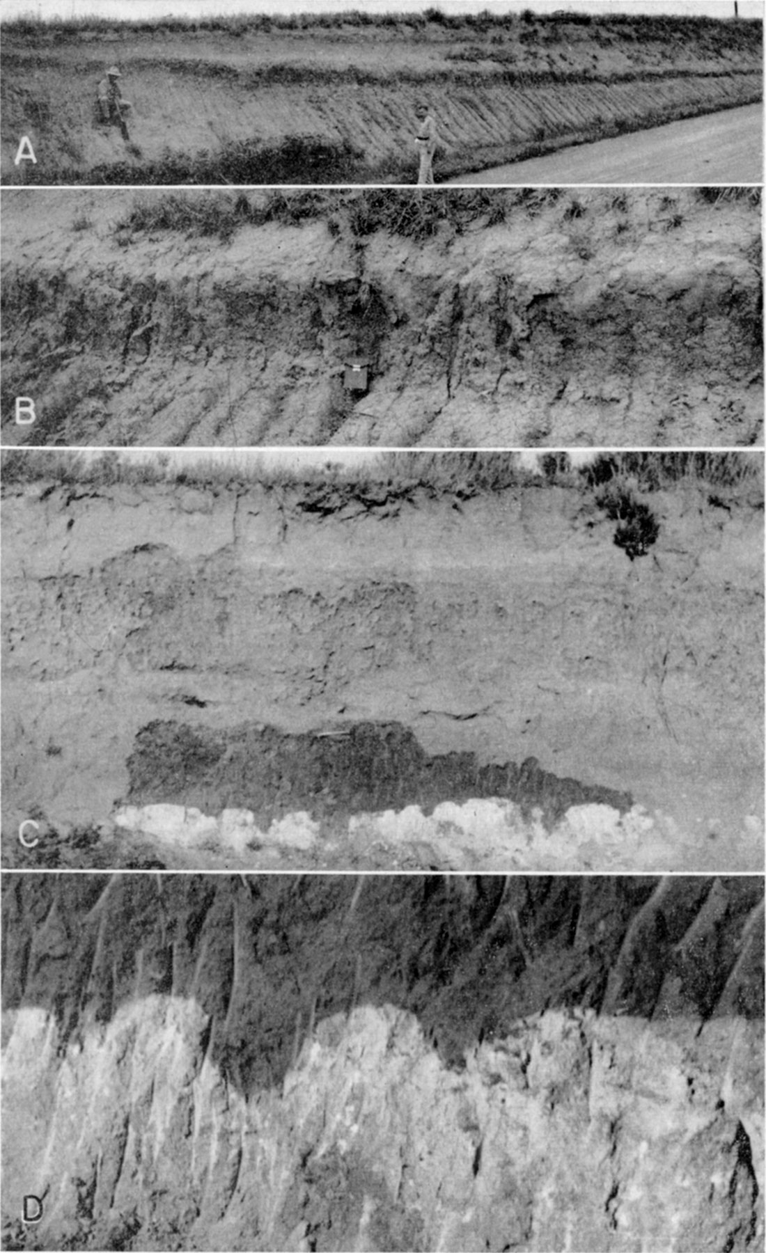
The Bradyan Sub-Age is an interglacial interval of relatively short duration characterized by stable soil-forming conditions. Occurring between the Tazewellian and Caryan Sub-Ages it serves to divide the Wisconsinan into two unequal parts. This sub-age (substage) takes its name from the Brady buried soil (Pl. 12) described by Schultz and Stout (1945, p. 241) from exposures in the south wall of the Platte River Valley in sec. 3, T. 12 N., R. 29 W., Lincoln County, Nebraska. The name has been used generally throughout northern and western Kansas.
Plate 12--The Brady soil in western Kansas. A and B, Brady soill in Peoria loess overlain by Bignell loess, north of Speed, Phillips County (A.R. Leonard, 1947). C and D, Brady soil developed in early Wisconsinan alluvium containing molluscan fauna, overlain by thin alluvium containing late Wisconsinan soil which is overlain by 2 feet of Recent alluvial sand to the top of the cut. The top of the caliche zone of the Brady soil is sharply defined in this alluvium of silty sand (1951).
With reference to Brady buried soil where developed on Peoria loess in north-central and western Kansas and southern Nebraska, Thorp, Johnson, and Reed (1951, p. 9) make the following statement:
Some of it is a Chernozem-like silt loam without textural variation in the profile; and some of it has a mottled subsoil suggesting that it may be a preserved Wiesenboden or Humic-Gley soil. The Bignell loess, that overlies the Brady soil in places, has in it a succession of dark bands or weak soils that represent short periods of pause or slow-down in loess deposition. 'Double soils' with one dark A horizon superimposed over another, and in places with claypans in the buried soils as described by Williams (1945), are very common in the regions where Chernozem, Chestnut, and Brown soils are developed in Peoria and younger loess. The 'double soils' are most distinct near the probable sources of the loess, and the two A horizons blend on the plains a few miles from these theoretical sources. Thus the 'Brady soil' in many places is a part of the modern soil.
Unlike the Sangamon soil, which is observable almost continuously east-west across northern Kansas and north-south across western Kansas, the Brady buried soil has regional extent only in the northwestern quadrant of the State. In the Missouri River Valley bluffs of Doniphan County Brady soil is exposed below Bignell loess at a few localities (Iowa Point section) and has a maximum depth of 14 feet. However, west of Missouri River Valley the Brady has not been recognized with certainty in eastern Kansas.
In northwestern and west-central Kansas Brady buried soil has been recognized at most localities where the Bignell loess has been observed resting on Peoria loess. It is best exposed in the area from Phillips County (Pl. 12A, 12B) westward through Norton County (SE SW sec. 11, SW sec. 14, and NE cor. sec. 23, T. 2 S., R. 23 W.; SE NE sec. 22, T. 4 S., R. 23 W.; NE cor. sec. 10 and NW cor. sec. 18, T. 5 S., R. 22 W.), Decatur County (SW sec. 23, T. 4 S., R. 27 W.; SW sec. 36, T. 5 S., R. 29 W.), Rawlins County (Pl. 11A), and into Cheyenne County (SE SE sec. 28, T. 3 S., R. 39 W.), and southward through Graham County (NE NE sec. 14 and NW NW sec. 36, T. 6 S., R. 23 W.), Thomas County (NE sec. 7, T. 8 S., R. 35 W.), Logan County (NE sec. 32, T. 12 S., R. 37 W.), Greeley County (NW sec. 9, T. 16 S., R. 40 W.), and into Scott County (SE sec. 6, T. 17 S., R. 32 W.). Throughout this region the Brady is developed in Peoria loess, the profile is moderately to poorly drained, and the depth of leaching ranges from about 1 to 3 feet. The A horizon is generally dark and caliche nodules one-half to 1 inch in diameter occur in the base of the B horizon. The B horizon is generally dark gray to gray brown and in some localities has clay accumulation and good structure whereas at other localities little textural contrast occurs between the A and B horizons. The profile of the Brady is generally deeper than the modern profile developed on the overlying Bignell loess, but this contrast may not be significant because at many of the Brady exposures this buried soil is judged to have developed under conditions of poorer drainage than did the modern soil at the same locality.
As exposures of early Wisconsinan alluvium are virtually nonexistant in northwestern Kansas, the Brady buried soil is known only from the loess section on uplands and intermediate levels in this region. In south-central Kansas, however, the Brady has been studied at a few localities (Pl. 12B, 12C) where it is developed in alluvial deposits. Here it is more strongly developed than in the north, the B horizon has a pale reddish cast, and the caliche zone is thick with a sharp though crenulate boundary at the top.
Although Bignell loess has not been recognized in southwestern Kansas, a soil developed in Peoria loess and overlain by dune sand (SE sec. 25, T. 29 S., R. 43 W., Stanton County) is judged to be approximately equivalent to the Brady. This soil is similar in morphology to the Brady soil of northern Kansas but is deeper and more strongly developed. As the age of the overlying dune sand has not been established the interval during which the profile developed is not known.
The evidence from the character of the Brady soil suggests that the climate under which it developed was much the same as that of the present. The degree of development, when contrasted with the Sangamon and older soils on the one hand and with the modern soil on the other, suggests that the Bradyan interval was comparable in duration to Recent time but was only a fraction (perhaps one-third to one-fourth) the length of the Sangamonian and earlier major interglacial ages.
Late Wisconsinan Alluvial Deposits
Alluvium of late Wisconsinan age occurs in virtually all the valleys of Kansas; it constitutes much of the surface area shown by the Wisconsinan and Recent patterns on Plate 1. Throughout the Kansas River basin (roughly the northern half of Kansas) post-Bradyan Wisconsinan alluvium, consisting of coarse to fine sand, silt, and small amounts of clay and gravel, underlies the surfaces of extensive low terraces. These low terraces occur 5 to 45 feet above the flood plains and commonly their height is 20 to 30 feet. Although in some valleys they are above maximum flood level in most places extreme flood crests cover their surfaces. This was dramatically illustrated by the maximum flood of record in the Kansas River Valley during July 1951 when all but the high points of the former natural levees on this terrace surface were covered by water for the first time since 1844. These rare episodes of flooding have added an increment, of unknown but probably small thickness, of Recent material to the surface of the terrace and have served to erase from the terrace surface the characteristic flood plain features, such as meander scrolls and abandoned channel segments. In the major valleys low and very gently sloping natural levees are nevertheless still distinguishable.
Along some of the valleys of northern Kansas this terrace, or terrace complex, has been studied, named, and mapped. In the Kansas River Valley it is called the Newman terrace (Davis and Carlson, 1952), in the North Fork Solomon River Valley, the Kirwin terrace (Frye and A. R. Leonard, 1949, A. R. Leonard, 1952), in Prairie Dog Creek Valley, the Almena terrace (Frye and A. R. Leonard, 1949), and in the Smoky Hill River Valley the Schoenchen terrace (A. R. Leonard and D. W. Berry, in preparation). Similar terraces have been studied, but not formally named, in South Fork Solomon River Valley, Republican River Valley, Sappa Creek Valley, Hackberry Creek Valley, and several minor tributaries to Kansas River. The existence of this system of low terraces throughout all but the western-most part of the Kansas River basin in Kansas indicates a uniform history of late Wisconsinan alluviation throughout this region followed by dissection and development of the modern flood plains during Recent time.
A rather persistent feature of the low terraces is the presence within them of a weakly developed, but black and distinctive soil band. This soil commonly occurs above the level of the active flood plain and from 5 to 15 feet below the surface of the terrace. It has been observed in this terrace along many of the valleys in northern Kansas (NE sec. 34, T. 3 S., R. 17 W., Phillips County; SE SE sec. 15, T. 3 S., R, 24 W., Norton County; SE NE sec. 1, T. 13 S., R. 29 W., Gove County) where it is a moderately to poorly drained immature profile; in some exposures it is associated with both higher and lower humic bands which suggest very short periods of surface stability.
The late Wisconsinan to early Recent age of these low terraces is indicated by their contained fossil mollusks at many localities, by the fact that the Peoria loess and Brady soil (which do not extend over the terrace surfaces) are at some places truncated by the valley sides, by their extremely youthful physiographic expression, and by the observed flooding of their surfaces by maximum floods. That their period of major alluviation was terminated in latest Wisconsinan or early Recent time is demonstrated by their relation to the modern active flood plains which are cut appreciably below the low terrace surface. The age of the persistent weak soil in the upper part of the terrace deposits is not known--it may be as young as early Recent.
Along some of the northern valleys tributary to Arkansas River in the central part of the State late Wisconsinan alluvium constitutes the only recognizable terrace. An excellent exposure of these deposits is afforded by an artificial channel cut in the SE SE sec. 9, T. 21 S., R. 5 W., McPherson County. In this section the modern top soil is strongly developed (leached 18 inches with reddish B horizon and prominent caliche zone) in sandy material. A Wiesenboden profile developed in silt and sandy silt (A and B horizons very dark, caliche zone at base of 12 to 18 inches of leached material) occurs 3.5 feet below the terrace surface. Below this buried soil, which may correspond in age to the persistent buried low terrace soil of the Kansas River basin, a post-Bradyan molluscan fauna was collected. At a depth of 9 to 10 feet below the terrace surface is a second buried soil (leached 2 feet, dark A horizon, and a reddish cast to the B horizon) developed in calcareous reddish silt that overlies sand down to the channel level.
A comparable terrace, both in form and deposits, occurs along Sawlog Creek Valley (Cen. E. line sec. 27, T. 23 S., R. 22 W., Hodgeman County) where a post-Bradyan molluscan fauna was collected below a buried soil and along Pawnee River Valley (SE cor. sec. 20, T. 21 S., R. 21 W., Hodgeman County).
South of Arkansas River Valley, in extreme south-central Kansas, late Wisconsinan alluvium occurs in many of the valleys under a distinct terrace surface at a level lower than the adjacent early Wisconsinan terrace. The bedrock floor below the two terraces also shows distinct offset in level. This relation is well shown by exposures in the cut bank of Medicine Lodge River in the NE SW sec. 20, T. 33 S., R. 11 W., Barber County. Near these exposures on the surface of the second terrace (possibly the type of Knight's Gerlane formation) is the town of Gerlane. The channel bank exposure shows the terrace deposit to consist of sand and silt grading downward into sand and gravel which rests on Permian shale and siltstone at a level 3 to 4 feet above normal water level in Medicine Lodge River. The late Wisconsinan terrace truncates the "Gerlane" terrace and its bedrock floor is an unknown depth below channel level. This terrace consists predominantly of sandy silt and clayey silt; it contains a buried soil (dark A horizon and weakly developed B horizon) about 4 feet below the terrace surface; a post-Bradyan molluscan fauna was collected from below the base of the buried soil profile. This terrace with its contained buried soil is in turn truncated by the flood plain sediments, the surface of which stands at approximately the same level as the bedrock floor of the second or "Gerlane" terrace.
The relation of these young terraces is also shown by fossiliferous exposures along East Branch Plum Creek, in the Cen. E2 sec. 35, T. 34 S., R. 8 W., Harper County. Along this small valley the terrace deposits are thinner and the young terrace (containing a post-Bradyan molluscan fauna) is quite narrow but the physiographic relations are similar to the locality described along Medicine Lodge River.
In the area of east-central and southeastern Kansas it is judged that late Wisconsinan alluvial deposits are generally indistinguishable from Recent alluvium and constitute a part of the flood plain complex in most of the major valleys. Minor flood plain terraces have been observed in many of these valleys but precise dating has as yet not been attempted.
Bignell Member, Sanborn Formation
The Bignell loess was named by Schultz and Stout (1945, p. 241) from exposures along the south bluff of the Platte River Valley, near the town of North Platte, in sec. 3, T. 12 N., R. 29 W., Lincoln County, Nebraska. Thin discontinuous deposits of Bignell are distributed widely over the northwestern quadrant of Kansas (at all localities cited for Brady soil in previous section). In that area the member is generally less than 10 feet thick, resembles the underlying Peoria loess in lithology, and contains a distinctive, though sparse, molluscan fauna. Its stratigraphic position is shown in the measured sections of the Peoria member.
In northeastern Kansas Bignell loess occurs discontinuously along the Missouri River Valley bluffs in Doniphan County, where it has the maximum thickness (35 feet) observed in the State (Iowa Point section). In Doniphan County this loess has a relatively dense concentration of snail shells.
In central Kansas the Bignell loess occurs only at a few places (measured section in Rice County) and is quite thin and non-fossiliferous. It has not been recognized in southeastern or southern Kansas.
Wherever observed the Bignell loess is so similar to the Peoria that it can be distinguished from it only by the presence of the Brady soil stratigraphically below it or by its contained molluscan fauna. Quantitatively it is insignificant in comparison to the Peoria member.
The Bignell, like the Peoria and Loveland members of the Sanborn formation, is intended to include, in addition to the loess, alluvial silts that are stratigraphically continuous with it. Therefore, it might be appropriate to class within the Bignell member some of the silty upper part of the late Wisconsinan alluvial deposits. This has not been the practice in Kansas because stratigraphic continuity between the two environments of deposition has not been established for the Bignell as it has for the older silt members, the exact age of the deposits has not been determined, and the alluvial materials are always mapped on the basis of their physiographic form without formal stratigraphic name.
The age of the Bignell is determined to be Caryan-Mankatoan because it rests on Brady soil (developed during Bradyan time in Tazewellian deposits); it contains a fauna distinctly younger than the Tazewellian fauna of the upper zone Peoria and perhaps somewhat older than the living fauna of the region; physiographic relations indicate that it was deposited prior to the development of the Recent flood plain sediments; and the surface soil developed in its top is roughly comparable in degree of development to the Brady buried soil. Although these data establish it as late Wisconsinan they do not permit definite correlation of the Bignell with Caryan or Mankotan, nor for that matter do they clearly exclude it from earliest Recent time. It is our judgment that its deposition started in Caryan time and extended through Mankatoan time.
Recent Stage
The Recent Stage is comprised of those deposits made since the extinction of the Mankatoan glacier as an active force, or during "the last 10,000 years." The Recent Age is exceedingly short when compared with the other ages of the Pleistocene; also it is difficult to delimit. Its fauna includes the present living fauna of the region and possesses far fewer elements of contrast with late Wisconsinan faunas than are present even within the Wisconsinan. Evidence from the morphology of soil profiles indicates that the Recent Age is no longer than the Bradyan interglacial Sub-Age and merits an age (stage) classification only because of its recency and the fact that we live within it.
Recent deposits in Kansas consist of alluvium under the surfaces of some flood plains and in the upper part of some low terrace deposits, the surficial part of the eolian sand included in many of the sand dune tracts, and possibly also a small quantity of eolian silt or loess. Although these deposits are quantitatively of small significance, the fact that wherever they occur they are the surface materials makes them geographically important (Pls. 1, 2). Thin colluvial veneers on many slopes and much of the modern soil developed during Recent time.
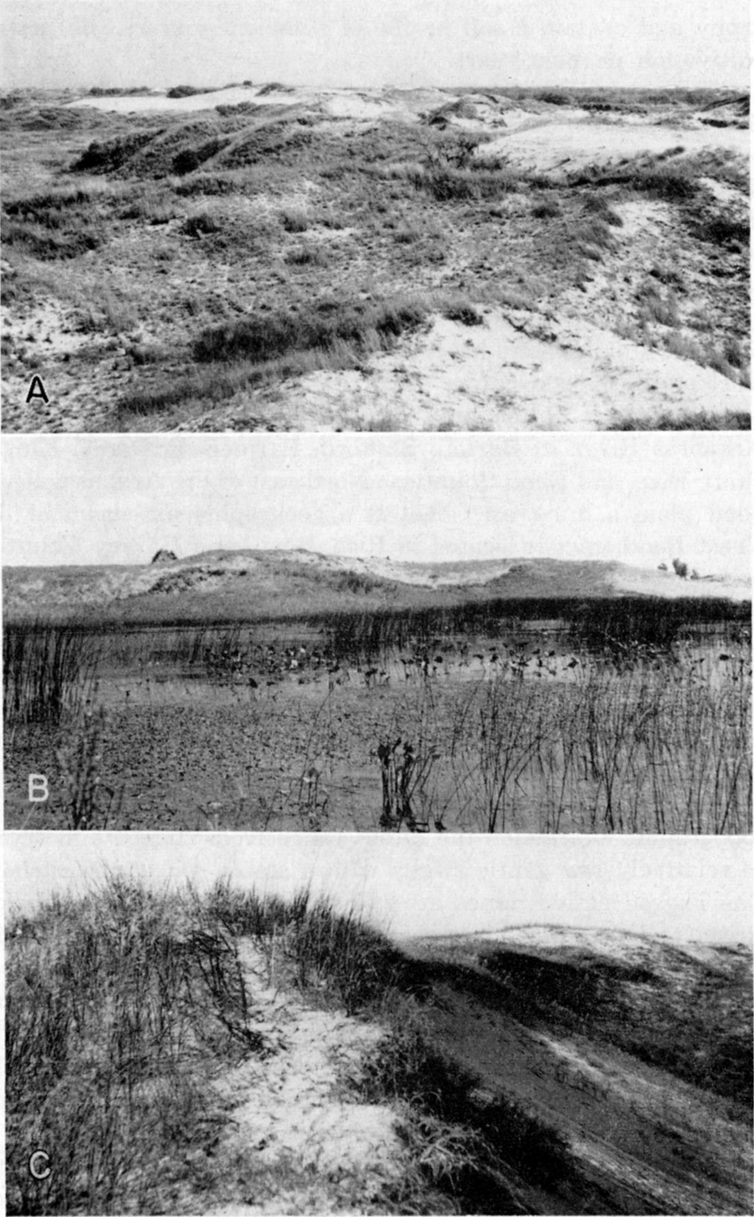
Eolian sand, consisting of well-sorted, moderately to well-rounded, generally noncalcareous arkosic sand and displaying a recognizable dune topography, occurs at the surface of approximately 3,500 square miles in Kansas (Pl. 1). During the present century dunes have been migrating actively over a relatively small fraction of this area. In some localities (Pl. 13) the sand is in striking dune form with individual dunes attaining a maximum height of as much as 70 feet (Smith, 1940, p. 153) whereas in other areas the dunes constitute gentle swells in the topography and contain a soil profile of sufficient maturity to permit cultivation in most years.
Plate 13--Late Pleistocene sand dunes. A, Active dune area on post-Bradyan Wisconsinan surface north of Cimarron River in the "Englewood basin" SW SW sec. 8, T 35. S., R. 24 W., Clark County (Ada Swineford, 1951). B, Small pond and bordering dunes west of "Salt basin" in the Great Bend sand dune tract; NE sec. 29, T. 21 S., R. 11 W., Stafford County (Ada Swineford, 1951). C, Active dune area on south side of Arkansas River Valley west of Syracuse, Hamilton County (Ada Swineford, 1951).
The sand dune tracts are discussed as part of the Recent Stage because in most areas the last episode of dune formation, or eolian sand migration, occurred during Recent time; however, the major dune tracts were initiated, and may even have had their major development, during Wisconsinan time. A formal stratigraphic name has not been applied to these surficial eolian sands in Kansas.
The largest dune tract in Kansas, and one of the larger tracts in the United States, has been referred to as the Great Bend tract or the Kinsley dune tract (Pl. 1). This expanse of dunes occupies much of the area enclosed within the great bend of Arkansas River in Barton, Stafford, Pawnee, Edwards, Kiowa, Pratt, Rice, and Reno counties. Northeast of the Arkansas River flood plain a dune tract that is a geographic extension of the Great Bend tract is located in Rice, Reno, and Harvey counties and is called the Hutchinson dune tract. Westward along the south side of Arkansas River there is a continuous belt of dunes extending from the Great Bend area to the Colorado state line. This belt of dunes expands into a sizable area called the Garden City dune tract in southern Kearny and Finney counties and central Gray County. This entire integrated dune complex, covering an estimated 3,000 square miles, is genetically related to Arkansas River and its Illinoian and younger deposits. In topographic expression the dunes range from rugged and active to relatively low gentle swells with a stable soil at the surface. The rugged active dunes are commonly located near Arkansas River, and the areas more remote from the river present, on the average, a more subdued topography. The presence of moderately mature surface soil profiles 12 to 18 inches deep on some of the subdued dunes does not necessarily indicate great antiquity as the original sands were noncalcareous, highly permeable, well drained, and covered with a prairie flora, all factors conducive to rapid development of dark-colored soils.
Within the Great Bend dune tract and its extensions, several cycles or episodes of dune formation have occurred within late Pleistocene time. Buried soils are present below the younger sands and are well exposed in the Hutchinson area (cut of Chicago, Rock Island, and Pacific Railroad in secs. 15 and 22, T. 22 S., R. 5 W., Reno County). The earliest dune sands in this area are known to be no older than early Wisconsinan as Crete sand and gravel and Loveland silt occur extensively below the sand (Pl. 1). As the dunes rest on a floor of fossiliferous Peoria silt at some places (near Bear Creek bridge in the NW sec. 12, T. 28 S., R. 41 W., Stanton County) it is judged that much of the dune formation occurred in late Wisconsinan and Recent time.
South of the Arkansas River area, several disconnected dune areas occur on the High Plains surface. Some of these (southeastern Pratt County) have not furnished evidence of multiple periods of development, whereas others (the Fowler area) display evidence of several cycles. In the Fowler area the dunes occur along the margin of a late Wisconsinan or Recent temporary lake (Frye, 1942) and rest on a floor of fossiliferous Sappa silt. Two well-developed buried soils separating units of dune sand are exposed in the cut of the Rock Island Railroad in sec. 35, T. 30 S., R. 26 W., Meade County. The youngest dune sand here is Recent in age but the older cycles may be Wisconsinan in age.
An extensive area of low subdued dunes occurs on the High Plains surface both north and south of Cimarron River in Morton, Stevens, Seward, and Meade counties. At a lower level, several tracts of dunes, in some places resting on a floor of late Wisconsinan alluvium, occur near Cimarron River in southern Clark County (Pl. 1).
Smith (1940, pp. 153-168) has discussed the sand dunes of southwestern Kansas and described a cycle of development as follows (p. 160):
The dune cycle embraces two distinct phases, characterized by different processes: first an eolian, or active stage, and, second, an eluvial, or passive phase. During the eolian phase, the dune is built up. Stabilization by vegetation introduces the eluvial phase, throughout which the dune is projected from wind attack, and undergoes gradual wasteage through weathering and creep. This second phase of the cycle, however, is subject to interruption through rejuvenation, whereby wind action is resumed and a new cycle inaugurated.
Virtually all major valleys and many minor valleys in Kansas contain active flood plains composed of Recent alluvium. Many of these flood plains should be considered "complexes" as they possess minor terraces, or pseudoterraces formed by point-bar accretions, meander scrolls, incipient natural levees, or eolian scour and deposition. The surficial material of some low terraces that stand distinctly above the adjacent flood plain is Recent in age and the material "of the active flood plain is Recent--perhaps in large part late Recent--in age. In many of the major valleys (Kaw, Republican, Prairie Dog, etc.) the Recent alluvial deposits are a minor insertion into the upper part of the late Wisconsinan alluvium and are underlain by the slightly older deposits. However, in some other valleys, particularly in south-central Kansas, Recent alluvium was deposited in an erosional trough that had been cut into bedrock through the late Wisconsinan fill. In some valleys in east-central Kansas (Cottonwood-Neosho system) Recent alluvium has not been differentiated from the Wisconsinan deposits. Alluvium of silt, sand, and gravel deposited during the Recent Age is quantitatively minor, is now in the process of deposition or modification by erosion and redeposition, has been assigned no formal stratigraphic name, and will not be discussed in detail.
Prev Page--Stratigraphy--Yarmouthian Stage || Next Page--Paleontology--Nebraskan and Kansan
Kansas Geological Survey, Pleistocene Geology
Comments to webadmin@kgs.ku.edu
Web version August 2005. Original publication date Nov. 1952.
URL=http://www.kgs.ku.edu/Publications/Bulletins/99/05_strat4.html