![]()
Prev Page--Introduction || Next Page--Classification and Correlation
Geologic Processes
It is the purpose of this report to present a discussion of the character, distribution, associated faunas, correlation, and significance of the many Pleistocene deposits of Kansas. General discussions of physical geology are presented in the many excellent textbooks in the field, and a detailed presentation of glacial geology is given in the recent textbook by Flint (1947). Nevertheless, it seems advisable to preface this description of Kansas Pleistocene with a brief summary of those physical processes that were of primary importance in the formation of the surficial deposits in the State and the shaping of the Kansas landscape. Although the Pleistocene geologist may wish to pass by this portion of the report, it is designed to furnish a background of understanding to the agriculturalist, the engineer, or the industrialist who has need for the specific data presented in the remainder of this bulletin.
The Pleistocene deposits of Kansas, of course, are entirely nonmarine but represent the full range of depositional environments that occurs on the continental interior. Deposits made by glaciers are present in northeastern Kansas and have lent distinction to the Pleistocene Series generally. Deposits formed by streams occur widely over the State, as do sediments produced by the action of winds. Smaller in quantity, but of real significance, are materials that accumulated in standing bodies of water, and others that were formed by mass movement, creep, or colluviation on slopes of various angles. The recognition and understanding of these several kinds of deposits requires some knowledge of the processes that produced them.
Furthermore, weathering has been the prime factor in the development, not only of the surface soil but also of the buried soils that are used extensively for correlation. Erosion in its many aspects has shaped much of the existing topography. The surface of Kansas is a direct result of physical processes operating throughout Pleistocene time.
Glaciation is discussed first because it played a controlling role, both by its abnormal prevalence during the Pleistocene Epoch and its control of cyclic pulses of stream sedimentation. Fluviatile or stream sedimentation logically follows glaciation, and as eolian sediments were in large part derived from flood plains of streams, a discussion of them follows. Modification of sediments by weathering is discussed next, and finally the destruction or modification of both Pleistocene deposits and older bedrock by erosion and pedimentation is described. The degree of agreement among geologists is less for the last three than for the first two of these topics. As this section is intended primarily for nongeologists, in some cases controversial subjects are treated somewhat arbitrarily and interpretations are given which we judge to fit best the objective data in Kansas.
Glaciation
Although continental glaciation as a physical process has not been operative in Kansas since mid-Pleistocene time, it exerted a profound influence on the shaping of the Kansas landscape throughout the entire epoch. It is beyond the scope of this report to consider the controversial problem of the cause of continental glaciation (Flint, 1947). Suffice it to say that conclusive evidence demonstrates that during several segments of Pleistocene time the rate of snow accumulation exceeded the rate of melting at two major centers in Canada. These areas of principal accumulation, or dispersal, have been called the Keewatin center (west of Hudson Bay) and the Labradoran center. As the snow thickness increased in these areas, the lower layers were changed by overlying weight and by thaw and refreeze into granules of ice called neve or firn. The neve was converted at still greater depths into glacial ice. As these masses of ice attained sufficient thickness the weight induced a plastic flow of the lower part of the glacier, much the same as a mound of warm tar will flow outward in all directions if more tar is added at the center (a discussion of glacial, motion is given by Matthes, 1942, and Flint, 1947). Continental glaciers continued to expand as long as the quantity of added winter snow, or nourishment, exceeded the quantity lost by melting during the summer season. The balance between nourishment and wastage fluctuated past the critical point and therefore the outer margin of the glacier fluctuated.
During two of the major glacial ages (Nebraskan and Kansan) continental glaciers that originated in the Keewatin center expanded to such an extent that they reached into northeastern Kansas. During early and late Wisconsinan time other continental glaciers reached into the central Missouri River basin although these failed by several hundred miles to reach the borders of Kansas.
The fact of continental glaciation was demonstrated beyond doubt more than a half century ago by the presence in the deposits (till) of stones transported across divides from distant sources, by the huge size of these erratic or "foreign" boulders, and by the general character of deposits and surface features. The name "till" is generally used to designate deposits made directly by glacial ice, and "drift" includes a wider range of associated fluviatile, lacustrine, and other deposits. In the Kansas tills pink quartzite is the most distinctive "foreign" rock and is found almost everywhere in our glacial materials. The nearest bedrock source of the pink quartzite found in the tills of Kansas occurs in southeastern South Dakota and northwestern Iowa. As this area is almost on a direct line from the inferred Keewatin center to northeastern Kansas the presence of these pink quartzite boulders confirms the conclusion that the glaciers that invaded Kansas originated in that center.
It seems obvious that the slow movement of several thousand feet of glacial ice across any area would produce radical changes in the terrain. The aspect of much of northeastern Kansas is the direct result of the action of continental glaciers. Glacial ice in motion has the capacity to erode the rock over which it passes; to transport rock fragments of large and small size; and to deposit the material or debris that it has carried. Glacial erosion is more vigorous in the interior part of a glacier where the ice is thickest but some erosion occurs locally even at the maximum limit of glacial extent as shown by striations (shallow grooves cut by stones held in the lower part of the ice) such as those that may be seen in the limestones that form the bluffs of Kaw Valley east of Bonner Springs. At other places (southwest of Atchison) the glacier "plowed up" evenly bedded water-deposited sand and silt, and at still other places shales of Pennsylvanian age were gouged out to various depths.
In contrast to these evidences of glacial erosion, observations indicate that in some places a continental glacier passed over an area without eroding it at all. A good example of the occasional failure of glaciers to erode underlying materials is afforded by the exposures in northeastern Doniphan County (Iowa Point section) where Kansas till rests on the top of an undisturbed soil in Nebraska till, which shows that the Kansan glacier here passed over the surface of this old soil without noticeably disturbing it.
Deposition rather than erosion was the predominant effect of the glaciers that invaded Kansas. Predominant deposition is characteristic of the terminal area of all glaciers. The presence of snails known to be adapted to temperate climates in ice-associated deposits and lack of frost features strongly suggest that the climate of Kansas was not conducive to glacial accumulation even at the climax of a glacial age. Therefore, glaciers existed in this area only because the rate of inflow from the north exceeded the rate of melting, in much the same manner that the end of a rod of ice can be maintained in an oven if it is pushed inward as fast as it melts at the end. Rock debris, produced by erosion farther north and incorporated into the glacial ice, was transported southward by the glacier and deposited at its terminus. Deposition by a glacier took place by "dumping" as the ice melted at its terminus; by decrease in carrying power as the glacier became thinner in the marginal area; by the stagnation of glacial segments; and by streams flowing on, within, and at the base of the glacier. Deposition occurred most rapidly at the edge of the glacier where its transporting power was lost. However, this terminal edge of the glacier fluctuated in position and during the waning phase of a glacial age it retreated toward the north and northeast.
A continental glacier may vacate an area either by becoming thin and impotent or by progressive retreat of the margin while the ice mass maintains active movement. Conditions intermediate between these two extremes, or perhaps combinations of them, may have been common in the many ice caps of the Pleistocene (Flint, 1947, chapter 9). Till thicknesses in excess of 300 feet at localities more than 50 miles from the ice limit (Frye and Walters, 1950) and the lack of ablation moraine or vertical differentiation in the till indicated that the Kansan glacier retreated from Kansas while maintaining forward motion all along its margin. The absence of a clearly recognizable terminal moraine in the State suggests that the glacier maintained itself at its maximum extent for only a short time although terminal moraine may have been eroded beyond recognition.
Deposits made by glacial ice are distinctive even though heterogeneous. The many specialized depositional land forms and their associated sediments common in regions covered by late Pleistocene glaciers, such as drumlins, eskers, kames, kame terraces, and recessional moraines, are not discussed here because they have not been recognized (or only doubtfully recognized) in Kansas. The till deposits of Kansas may be considered to be largely ground moraine. Except where modified by weathering, the till is calcareous, some hue of gray in color, and generally fine-textured even though it is locally quite coarse and contains boulders more than 6 feet in diameter. Test drilling shows that the till contains many lentils of sand and gravel. These inclusions of sand and gravel are judged to be polygenetic. They represent deposits of outwash made at the margin of the glacier and later overridden by a readvance of the ice front, englacial and subglacial stream deposits, and incorporation of masses of sand, silt, or gravel locally known to have been moved as frozen blocks into the till by the plowing action of the glacier.
Another effect of continental glaciers, unobservable today but of great importance to the development of our streams, was regional crustal warping caused by the weight of the glaciers. Flint (1947, chapter 19) has summarized the evidence of crustal warping, even now not fully compensated, that resulted from the last glaciation. As a load of several thousand feet of ice is applied to the surface of the earth the crust slowly yields and adjusts to the pressure; as the ice load is removed the crust slowly readjusts to its former position. Although it is not possible to obtain direct evidence that such isostatic adjustments resulted from the accumulation and dissipation of the Kansan glacier, it is inconceivable, since such movements were produced by the relatively small latest Pleistocene glaciers, that such movements did not occur as a result of the earlier and much more extensive Kansan glaciation.
Fluviatile Sedimentation
Sediments deposited from currents of flowing water are quantitatively the most extensive of the Pleistocene materials in Kansas. Stream action has been a topic of study since the beginnings of geology as a science and the mechanics of the process are known in considerable detail (Gilbert, 1914; Rubey, 1938). Briefly stated, a stream (a) may transport its load of rock debris without net erosion or deposition; (b) may erode its channel and by so doing add to the quantity of material it is carrying; or (c) may give up or deposit some of the rock materials in transit and so decrease its load. Which of these three conditions obtains at any particular time or place is controlled by the interrelation of three measurable factors: (1) the quantity of water moving in the stream; (2) the quantity and character of the rock debris being transported by the stream and available to it, and (3) the velocity with which the water moves, mostly controlled by the stream gradient. The discussions of fluviatile sedimentation all relate themselves ultimately to the modification of one or more of these three controlling factors. For example, a sudden increase in the quantity of fine rock material furnished to a stream might change it from an eroding to a depositing one.
In the vicinity of continental or mountain glaciation each of the three major factors that control stream deposition is importantly affected by the activity of the glacier. Accelerated precipitation rates, retention of water in glacial ice, or its release by glacial melting influence water volume in streams. The burial of sediment sources under rapidly advancing glaciers, the discharge of debris at the margin of a stabilized glacial front, and the release of progressively greater areas of finely comminuted rock debris as a glacier front retreats influence the volume and character of the sediment load available to streams. Isostatic warping of the surface near the margin of a glacier may cause an increase, a decrease, or in special cases a reversal of the stream gradient which largely controls the velocity of the flowing water. In addition to these basic effects on stream action, the physical presence of a continental glacier, by blocking draingeways with ice, till, or outwash sediments, or by otherwise altering the load or flow, may importantly modify the regimen of streams. Furthermore, in the continental interior these glacial effects go far beyond the limits of glaciation and similar histories of erosion and deposition are found in separated stream basins that were not invaded by glaciers. The similar histories in unglaciated and glaciated river basins are judged to be due to the fact that many of these streams joined glacially headed streams in their lower courses and that the climatic fluctuations, particularly changes in precipitation rate, that were associated with episodes of glaciation were far-reaching in effect.
Another indirect effect of glaciation on stream deposition is by way of drainage changes. The action of glaciers disrupted drainage patterns and in some cases caused the breaching of former divides. Such disarrangement of drainage lines caused changes in gradients, volumes, and sediment loads.
In general, during the advancing phase of a continental glacier, precipitation rates must have been relatively high (or the glacier would not have been nourished), the available sediment was progressively diminished as the burial by ice protected progressively larger areas formerly subjected to stream erosion, and gradients may have been slightly increased near the glacial margin by isostatic "fore bulge" (Flint, 1947, p. 409) and were sharply increased in coastal areas by declining sea level. In other words, an increase in water volume, a decrease in available sediment load, and at least locally an increase of gradient combined to produce downcutting by streams during the early part of a glacial episode.
During the waning phase of a glacial episode the rock debris available as sediment load to streams was enormously increased by the uncovering of vast areas of glacial deposits and the removal of sediment by running water from the melting ice mass itself.
At least locally gradients were decreased by the subsidence of the isostatic "fore bulge" and rebound of the glacial floor and in coastal areas by the rise of sea level. The relative volume of water in streams during the early and late phases of glaciation is not known with certainty. It is possible that stream volumes decreased during glacial retreat, in spite of the large quantities released by melting of ice, because of decreased precipitation rates and rise in temperature (and resultant evaporation), but it is certain that the ratio of load to water volume in streams increased markedly. That is, marked increase of load and local decrease of gradient caused general stream alluviation during late glacial time.
In Kansas, Pleistocene stream alluviation was importantly influenced in all parts of the State by the episodes of glaciation. Sea level changes are judged to have had little if any effect on deposition or erosion in this continental interior region. The effect of sea level change on stream regimen must be projected headward along any stream by the migration of a steepened or flattened gradient and, other conditions remaining constant, the regimen of the stream above the migrating segment is unaffected by the change of sea level. The point in the channel where the gradient changes is called a "knickpoint" or interruption in the profile. If an oversteepened channel segment is working through loose alluvial materials it may move with considerable speed, but where relatively resistant rocks, such as the Pennsylvanian limestones of eastern Kansas, are being eroded it moves more slowly--requiring more than the allowable fraction of a glacial age to enter deeply into the State. The headward migration of a flattened segment of stream gradient is not controlled by local bedrock and may move more rapidly than an oversteepened segment. It is only remotely possible that an effect of rising sea level at the end of a glacial episode may be recorded in Kansas by the final deposition of silt that commonly concludes a glacial cycle of stream alluviation. Clearly, it is not necessary to call upon such an explanation to account for deposition of these fine sediments.
Eolian Sedimentation
The deposition of eolian Pleistocene sediments in Kansas was directly controlled by the activity of streams to almost the same degree as stream deposition was controlled by glaciation, because alluvial materials were the source of all eolian deposits. The mechanics of wind erosion, transportation, and deposition have been discussed by Bagnold (1941) and are beyond the scope of this bulletin. The factors controlling erosion, transportation, and deposition by wind are much the same as those controlling water deposition--importantly modified by the lower density and viscosity of air and the lack of restriction of air currents to definite channels. Glacial ice is capable of transporting and depositing huge boulders; streams carry and deposit rock fragments more than 1 foot in diameter; but air currents transport only particles of sand size or smaller. Furthermore, the coarser particles carried by winds are rarely lifted far above the ground surface and are carried relatively short distances in any one "jump," whereas silt-size particles are carried tens or hundreds of miles as a suspension load.
Deposits made by winds fall generally into two classes: (1) well-sorted sand typically displaying a dune form at the surface, and (2) massive exceedingly well-sorted silt. In general eolian silts and sands are distinct and are not gradational, even though deposits intermediate in texture are known to occur. Eolian sands are commonly moved as traction load whereas silts are always moved as suspension load. Eolian sands generally occur geographically near to their source of alluvial sediments whereas eolian silts may be distributed over wide areas. The textural distinctiveness of these two types of eolian deposits, the lack of quantitatively important intermediate deposits, the stratigraphic interbedding of eolian sand with eolian silt, and the general relation to independent and distinct source areas lead to the judgment that sediment source is the factor exerting most important control on eolian deposits.
The major dune sand tracts in Kansas are located near Arkansas River or its Pleistocene courses, whereas loess is not abundant in that region. It is judged that these sands were derived from the rapidly alluviating stream channels during late Pleistocene glacial episodes. The facts that dune sands are prevalent in this region whereas loess (or eolian silt) is relatively insignificant and that the Pleistocene alluvial deposits consist predominantly of sand and coarser materials indicate that the sediment load of Arkansas River during late Pleistocene time consisted of coarse clastic materials with relatively little silt. This is compatible with the geology of the Arkansas Valley west of central Kansas as the outcropping rocks along it consist of shales, chalks, Pliocene alluvium, granite, and other crystalline rocks which would furnish the stream with abundant clay, sand, and gravel but with a small proportion of silt. Sands, once derived from the alluvial source by wind action and piled in hillocks, have moved in successive "spurts" of migration (Smith, 1940) perhaps a few tens of miles from their original source.
The mode of origin of massive silt deposits has, in recent years, been a highly controversial subject (Russell, 1944; Leighton and Willman, 1950). Deposits consisting predominantly of silt and superficially displaying the same appearance have been produced in several ways. Swineford and Frye (1951) made a regional study of the petrography of the Peoria loess (early Wisconsinan) in Kansas, and state concerning its origin (p. 317):
Although some relatively structureless silts on slopes are derived colluvially from higher silt deposits (Elias, 1931) and some loess-like silts at low levels are water-laid, these studies have led to the conclusion that the extensive deposits of massive silts over thousands of square miles of upland and high-terrace surfaces are predominantly the result of eolian action. The facts contributing most importantly to this conclusion are (1) topographic position of loess on extensive divide areas, including highest elements in local topography; (2) textural similarity to that of modern wind-transported silt; (3) relatively uniform composition over an area of 30,000-40,000 square miles in Kansas alone, where the loess rests on various stratigraphic units of Pennsylvanian, Permian, Cretaceous, Pliocene, and Pleistocene age; (4) decrease in thickness and median grain diameter in directions away from major outwash-carrying valleys; (5) regional persistence of distinct faunal zones characterized by terrestrial snails; (6) lateral persistence of buried soil profiles which lack evidence of erosion or creep; (7) gradational contact of overlying loess units on buried soils; and (8) lack of any other known agent capable of depositing uniform silts simultaneously on sharply discordant topographic levels. In view of these facts, an eolian origin of the Kansas Peoria loess is accepted without reservation and is implicit in further discussions of local source and distribution patterns.
Swineford and Frye (1951) demonstrate that the major sources of loess in Kansas are the Platte River Valley of western Nebraska, the Missouri River Valley, and the Republican River Valley. If we examine the geology westward along Platte River Valley we see that it sharply contrasts with that along the Arkansas (the major dune sand source) by the presence of thick and widespread deposits of Tertiary silts which contain a very high percentage of silt-size material similar to that found in loess. The Missouri River Valley was an important avenue for the discharge of glacial outwash during Wisconsinan glacial episodes and also had available large quantities of silt-size materials. In outwash-carrying valleys, such as the Platte and the Missouri, during the melting season of the year flood waters intermittently covered the entire valley floor. On the retreat of each flood a sheet of sediment extended from valley wall to valley wall and as soon as the surface of this fresh sediment was dry it constituted an almost ideal source of silt for eolian transport. As these valleys were being aggraded rapidly with outwash and flooded with sufficient regularity to inhibit the growth of permanent vegetation, winds had free access to the silt source. In the eastern areas the valley walls were heavily vegetated and served as near-by settling areas for the air-borne silt. In the High Plains, however, a short grass flora prevailed and the winds were less restricted in the long distance transport of their silt load (Swineford and Frye, 1951).
The bulk of the eolian Pleistocene deposits in Kansas, both sand and silt, accumulated during the retreating phases of glacial episodes as it was then that broad alluvial flats were continuously replenished with sediments. However, wind action is possible at any time and winds of strengths adequate to transport sands now regularly occur in the State. Eolian deposits may accumulate whenever and wherever suitable sediment sources exist.
Weathering
Weathering, unlike the three agents of deposition--glaciation, stream action, and wind action--does not directly contribute new deposits but rather affects modification of existing deposits. Weathering by mechanical processes produces fragmentation of rocks and minerals without appreciable change in the composition of the constituent minerals. Among the agents of mechanical weathering are temperature changes, freezing of water, crystal growth, plant and animal action, wetting and drying, abrasion, and corrosion. Chemical weathering is more complex and as it commonly affects a change in chemical composition and mineral species, it is more profound than mechanical weathering.
Chemical weathering results generally in the reduction of particle size, the addition of water, oxygen, and carbon dioxide, and the loss of soluble salts of some metals such as sodium and potassium. Clay minerals commonly result from chemical weathering in a temperate climate and the color and general appearance of a deposit may be markedly altered.
Many general reviews of weathering process (e. g., Reiche, 1945) are available in the literature, and the following discussion is concerned primarily with the effects of weathering that are observable and usable in the study of Kansas Pleistocene deposits.
Soil development--The effect of weathering of all types has its most obvious expression in the development of surface soils. Soils are important to the Pleistocene geologist for several reasons, one of which is their use, when buried in a sequence of sediments, for stratigraphic classification and correlation. The nature, chemistry, and formation of soils have been discussed in a general way by Rice and Alexander (1938), Byers, Anderson, and Bradfield (1938), and Byers and others (1938), who have made the following statement concerning the nature of soil (p. 948):
Soils are natural media for the growth of plants. They are mixtures of fragmented and partly or wholly weathered rocks and minerals, organic matter, water, and air, in greatly varying proportions, and have more or less distinct layers or horizons developed under the influence of climate and living organisms. The cross section of horizons from the surface to the parent material is known as the soil profile. The degree of profile development is dependent on the intensity of the activity of the different soil-forming factors, on the length of time they have been active, and on the nature of the materials from which the soils have developed. Soils are dynamic in character--they are constantly undergoing change--but they normally reach a state of near equilibrium with their environment, after a long period of exposure to a given set of conditions, and they may change but little during periods of hundreds or even thousands of years unless there is a change in the environment.
It is apparent from this statement that "soil formation" is intended to include the advanced stages of weathering produced by both physical and chemical processes of both inorganic and organic origin, acting on rock materials already fragmented by earlier stages of weathering. Therefore, "soil forming processes" are effective only on a surface that possesses sufficient stability to attain this advanced stage of weathering. More than 90 percent of the surface of Kansas at the present time possesses this degree of stability, where it is not disturbed by man's activities, and comparable conditions have obtained at intervals within Pleistocene time.
As the forces contributing to weathering and soil formation come in contact with rock materials at or near the surface, soil development proceeds downward from the surface, and, other things being equal, the greater the length of time involved the deeper the soil. This progressively downward development also produces zonation of the weathering effects. In Kansas till, for example, oxidation (accompanied by hydration) of iron-beaming minerals has proceeded to depths of 30 to 50 feet. This oxidation alters the color of the till from its original bluish gray to a tan or yellowish brown and reduces its toughness or "brittleness." In this same till, leaching of calcium carbonate has proceeded downward only 5 to 15 feet. This leached zone includes the soil of the agriculturalist whereas the deep zone of oxidized material below is classed as only slightly weathered or as "parent material."
The soil proper is divided into zones that are referred to as A, B, and C horizons. The A, or uppermost horizon, has the least resemblance to the original rock material from which the soil developed; it has lost soluble constituents and some colloids but has gained in organic material; it may be loose and friable and commonly contains a relatively small amount of clay. The B horizon, second down from the surface, may also show extreme change from the fragmented rock below; it has lost some of the soluble constituents such as calcium carbonate but is enriched in perhaps also by the downward movement of colloids of clay produced by weathering in the A horizon above. B horizons display a wide range of structures which are in part controlled by the degree of dispersion of the clay colloids, and generally are tougher and more resistant to erosion than either the overlying A horizon or the underlying C horizon. In well-drained mature (or old) soils the B horizon is generally several times as thick as the A horizon. In dry to moderately dry climates calcium carbonate dissolved from the upper part of the soil accumulates as "caliche" in the lower part of the B horizon or upper part of the C horizon. The C horizon, which occurs below, the B horizon, generally displays no distinct structure. It consists of fragmented rock that is commonly altered chemically only by oxidation and hydration. C horizons in unconsolidated deposits may be quite thick as in the glaciated area of the State, whereas in indurated rock they may be quite thin, as in the central Flint Hills area.
These described characters of a soil profile apply primarily to the zonal or normal soils. In soil science three orders of soils are recognized (Baldwin, Kellogg, and Thorp, 1938, p. 987), the (1) zonal or normal, (2) intrazonal, and (3) azonal soils. These three orders have been briefly characterized as follows:
Thus the zonal soils include those great groups having well-developed soil characteristics that reflect the influence of the active factors of soil genesis--climate and living organisms (chiefly vegetation). These characteristics are best developed on the gently undulating (but not perfectly level) upland, with good drainage, from parent material not of extreme texture or chemical composition that has been in place long enough for the biological forces to have expressed their full influence.
The intrazonal soils have more or less well-developed soil characteristics that reflect the dominating influence of some local factor of relief or parent material over the normal effect of the climate and vegetation. . . .
The azonal soils are without well-developed soil characteristics either because of their youth or because conditions of parent material or relief have prevented the development of definite soil characteristics.
Of these three orders of soil only the zonal (normal) and intrazonal are usable by the geologist in his interpretation of conditions that existed on former surfaces now buried by younger sediments. During the present century, intrazonal soils on buried till plain surfaces have been studied extensively in the glaciated region of the upper Mississippi River basin. Wiesenboden (meadow soils) or humic-gley soils, and Planosols were described by Kay and Pearce (1920) as gumbotil and were used for stratigraphic correlation and as a basis for estimates of the duration of interglacial time. The morphology of these intrazonal soils is dominated by the effect of the one genetic factor--poor drainage. Where profiles of intrazonal soils are used for time estimates it should be remembered that the thickness of the gley layer (gumbotil) is influenced by minor details of microtopography, permeability of the till, position of water table, and other factors to such a degree that they may obscure the effects of time. Normal or zonal soils are developed in response to the balanced effects of many genetic factors and therefore are more indicative of regional conditions than are intrazonal soils. Within the range of buried Pleistocene soils in Kansas are to be recognized Chernozems, Prairie soils, Reddish Prairie soils, Brown soils, Chestnut soils, and other representatives of the great soil groups that are identified among the surface soils of Kansas.
The concept of the soil catena serves to emphasize the influence of surface features on the development of normal profiles. A soil catena has been defined as follows (Soils and Men, 1938, Glossary, p. 1164):
A group of soils within one zonal region developed from similar parent material but differing in characteristics of the solum owing to differences in relief or drainage.
It is the position within the catena that most easily confuses the field geologist in his examination of a buried soil. Parent material, its texture, mineral content, calcium carbonate content, and permeability generally can be determined. Geographic location gives a clue to climate by analogy with existing climates. But without a three-dimensional reconstruction it is difficult to estimate the position within the former catena occupied by buried soil exposed in a cut or penetrated by augering.
In well-drained to moderately well-drained zonal profiles in upland situations the effects of climate, flora, and fauna are closely related and climate is the dominant factor. In situations of similar drainage in the buried Pleistocene soils in Kansas the greater the depth of profile the higher the rainfall rate or the greater the length of time of formation, In areas where precipitation now exceeds 35 inches annually caliche zones are not present or are at considerable depth and are discontinuous. Maximum development of caliche zones is in the 25 to 30 inch rainfall belt. In the area characterized by less than 20 inches of annual precipitation A horizons commonly retain some calcium carbonate even though a weak caliche zone occurs at a shallow depth.
A controversial factor in the interpretation of buried profiles is the significance of reddish overtones to the brown B horizons in areas where the top soil B horizon lacks a red component. Although it has been contended by some that a reddish cast is indicative of higher temperatures, field relationships suggest that development during a longer period of time under stable conditions in a moderate climate may produce the same effect.
Soil-forming intervals--The formation of deep surface soils requires a relatively high degree of stability of the surface. The presence of such soil profiles at definite positions within the Kansas Pleistocene sequence of sediments indicates that conditions of relative surface stability have existed periodically throughout Pleistocene time. It is important for the interpretation of these sediments to know where within the glacial-interglacial cycle the "soil-forming intervals" occur.
Within the glaciated region soil formation obviously did not take place while glacial ice covered the area or in areas where its proximity gave rise to accelerated erosion or deposition. However, a till plain surface, far from an ice front or major drainageway, presents conditions well suited for continuous soil formation.
Till plains are crossed in various places by valleys cut into glacial deposits and bedrock and subsequently filled with waterlaid sediments. At some places both the till and alluvial valley fills are overlain by the next younger till sheet. Although there are differences of opinion as to the age of these alluvial fills and the interval during which soils formed on them (Frye, 1951a), the relations of outwash fills to the glacial cycle described in previous sections indicate that the fills are latest glacial in age and that the soils on them formed during interglacial time. Thus, they are approximately equivalent to the till plain soils.
Stratigraphically, the water-laid sediments and ancient soils in many places can be framed between till sheets, indicating definitely that the period of soil formation preceded deposition of the overlying till. The relation of Wiesenboden and Planosols (gumbotils) on till plain surfaces to filled valleys which are cut below their level has been taken as evidence that the valley incision occurred after development of the soils. However, poorly drained profiles are now forming on the undissected surface of young till plains, in some places within a few hundred feet of the steep walls of erosional valleys cut into the till plain. This suggests that earlier till plains may have been incised and valleys filled by stream action without materially affecting the progress of soil formation on the extensive interfluves. Furthermore, soils roughly comparable in development to the till soils are known to occur on some of these water-deposited sediments.
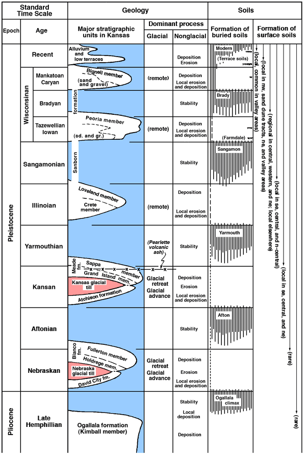
As most of Kansas lies beyond the glacial limit, we are particularly concerned with the placement of soil-forming intervals in the nonglacial sequence. As has been stated, evidence in Kansas indicates that valley incision was prevalent during glacial advance and maximum stand and alluviation during glacial retreat. Stratigraphically, cyclic units capped by a buried soil (Fig. 1) have been correlated from the Plains region with the glacial section and shown to possess the same succession as the tills.
Field data as well as theoretical considerations indicate that the interglacial intervals of the Pleistocene were times of soil formation and that glacial intervals were times of soil destruction or burial. Each cycle of glacial sedimentation is appropriately followed by soil formation. The Pleistocene stratigraphic sequence, as now known in Kansas, displays five major soil-forming intervals and several less distinct minor intervals (Fig. 1).
Figure 1--Chart showing cyclic arrangement of Pleistocene deposits in Kansas and major soil-forming intervals. The column at the right refers to surfaces that have been more or less continuously exposed to soil-forming processes. The vertical extent of each time division is arbitrary (Frye, 1951, p. 406.). A larger version of this figure is available.
Erosion and Pedimentation
Erosion, as defined in Webster's New International dictionary, is "the general process of the wearing away of rocks at the earth's surface by natural agencies." In this broad sense erosion includes all processes of degradation discussed in previous sections and its results are generally well understood. In central and western Kansas, however, erosional forms classed as pediments or "flanking pediments" are common. These surfaces are commonly veneered with debris in transit and since they have proved to be a source of confusion in the mapping of Pleistocene deposits they merit special notice.
Pediments have been studied and described from desert mountainous regions for many years. Mountain pediment is denned by Bryan (1922, p. 88) as a
. . . plain which lies at the foot of mountains in an arid region or in headwater basins within a mountain mass. The name is applied because the plain appears to be a pediment upon which the mountain stands. A mountain pediment is formed by the erosion and deposition of streams, usually of the ephemeral type, and is covered with a veneer of gravel in transit from higher to lower levels. It simulates the form of an alluvial slope.
Concerning the contrast of mountain slope to mountain foot plain Bryan (1922, p. 38) states:
The angles of the mountain slopes range from 15° to almost 90° with the horizontal; those of the plain from 1° to 6°. Between these slopes there is usually no region of transition, either of intermediate slopes or of low foothills. In many ranges slopes that average 25° to 30° rise directly from the plain to the crest of the mountains. The factors which produced the mountain slopes must then differ radically from those which produced the plain.
He further states (Bryan, 1922, pp. 52-53):
The normal mountain pediment has smooth slopes, broken only by scattered hills that rise abruptly from the plain and are more or less strung out in lines which are prolongations of the intercanyon ridges of the mountains.
It is clear from these statements that Bryan included in the term mountain pediment only the relatively gentle erosional slope, generally covered with debris, that meets the mountain slope at a sharp angle without transition. It is also clear that he considered the sharpness of this angle of juncture to be a function of climate as attested by the following statement (Bryan, 1940, pp. 260-261):
In the transition into the semi-arid regions where perennial grass clothes the slope, the zone of rainwash changes more gradually into flow in channels. The base of slopes merges with the pediment in a short, graceful curve similar to but generally less gradual than the transition curve of humid regions.
Although Bryan recognized the existence of pediment surfaces in semi-arid and even humid climates, such features have received little notice in Kansas literature. In 1942 Frye and Smith described features along parts of Cimarron and Smoky Hill River Valleys and referred to them as "pediment-like slopes." In this report, pediments of the semi-arid type developed along major and minor valleys in central and western Kansas are called "flanking pediments" from their flanking position with respect to the stream course.
Although genetically comparable to mountain pediments, the flanking pediments of relatively low relief of the Great Plains region of Kansas differ from them in their magnitude and their consistent control by the position of through-flowing streams. Flanking pediments present broad, slightly concave upward, smooth surfaces, locally marked by inselberge, which meet the steep valley-side wall with a more or less distinct transition curve. The several cycles of pedimentation that may be observed in southern Barber County and elsewhere show that the steep valley walls at the pediment heads retreat with essentially parallel slopes. These "pediment head" bluffs diminish in height as they migrate by projection of the pediment slope away from the stream course that serves as the controlling base level. In the High Plains section, and to a less marked degree farther east, the crest of the valley-side walls is sharp and the flat upland surface that stretches back from its crest is only slightly affected by erosion. Flanking pediments are developed in Permian, Cretaceous, Pliocene, and Pleistocene rocks, but have their most ideal expression in thick relatively homogeneous or massive rocks such as Permian redbeds and the Smoky Hill chalk member of the Cretaceous Niobrara formation (note Fig. 4).
The surface of a flanking pediment is commonly veneered with rock debris derived in large part from the steep valley-side wall at the pediment head. The pediment surface, although at least in its upper part being slowly lowered by erosion, serves as an avenue of transportation for rock material from the head slope to the stream channel. Rock debris as a sheet is transported across this surface by minor stream action, creep or lubricated creep, and rill wash. Lubricated creep is seemingly an important process in areas where the pediment is cut on rock of low permeability such as Niobrara chalky shales. The sheet of debris has a much higher permeability than the underlying bedrock which retards the downward percolation of water, and during periods of rainfall the lower part of the debris sheet is saturated. The flanking pediment veneers range in thickness from a trace to more than 20 feet and in texture from well sorted to very poorly sorted, but their lithology in all cases reflects the upslope source.
This sheetlike downslope transport of material across smooth relatively undissected surfaces has led to serious errors in mapping of Pleistocene sediments particularly in south-central Kansas. In parts of Barber, Harper, Sumner, Kingman, and other counties, gravelly Pleistocene deposits crop out in the steep valley-side walls at the heads of pediments cut in Permian shales and siltstones and have contributed arkosic gravels to the pediment veneer. Where these surfaces are undissected the gravelly veneer resting on eroded Permian gives the superficial appearance of extensive Pleistocene alluvial deposits. Hand augering on some surfaces that had been previously so mapped, however, revealed the veneer to be less than 10 feet thick. In this region the flanking pediments are quite young within the Pleistocene, and as the pediment veneer, in some places, is in intermittent transit it is judged more appropriate to consider these features as erosion surfaces. Therefore such deposits are not shown on the map of Kansas Pleistocene deposits (Pl. 1).
The term colluvium has been used in many areas of Kansas to include flanking pediment veneers where they are poorly sorted and are judged to be largely the product of creep or lubricated creep.
Prev Page--Introduction || Next Page--Classification and Correlation
Kansas Geological Survey, Pleistocene Geology
Comments to webadmin@kgs.ku.edu
Web version August 2005. Original publication date Nov. 1952.
URL=http://www.kgs.ku.edu/Publications/Bulletins/99/03_proc.html