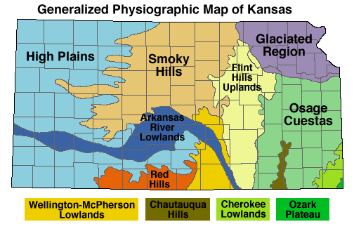
The Ozark Plateau in extreme southeastern Kansas is made up of rocks deposited during the Mississippian Period of geologic history, about 350 million years ago. Landforms in the Cherokee Lowlands, Osage Cuestas and the Chautauqua Hills are all Pennslyvanian in age, deposited about 300 million years ago. The Flint Hills of east-central Kansas and the Red Hills in the south-central part of the state are both Permian in age, roughly 250 million years old.
Cretaceous-age rocks, deposited about 100 million years ago during the time of the dinosaurs, form the landscape in the Smoky Hills. The High Plains of western Kansas are composed of rock debris washed off the face of the Rocky Mountains over the past few million years. The Arkansas River Lowlands and the Wellington-McPherson Lowlands are areas of recent deposition that border rivers. Glaciers moved into Kansas about 750,000 years ago and sculpted the northeastern corner of the state.
Click on one of the physiographic regions to display typical landscapes which characterize the selected region.
For more information about the state's geology, see the educational publications listed in the KGS Publications and Sales Catalog or the Kansas Geology Page.
Kansas Geological Survey
Updated March 14, 1997
Send comments to webadmin@kgs.ku.edu
The URL for this page is http://www.kgs.ku.edu/Physio/physio.html