![]()
Prev Page--Classification and Correlation || Next Page--Stratigraphy--Kansan Stage
Pleistocene Stratigraphy in Kansas
Knowledge of the character and distribution of Pleistocene deposits in Kansas is based largely on work during the past two decades by the Federal and State Geological Surveys and cooperating agencies. In this period the surface geology, including Pleistocene units, has been mapped in all or parts of 40 counties, and samples of Pleistocene materials from more than 1,000 test holes drilled by the cooperative Ground-Water Division of the Federal and State Geological Surveys and from several hundred hand auger holes bored to shallower depths have been studied. Although the work so far accomplished fails to provide all desired details concerning the character of Pleistocene strata, it has furnished us with an adequate basis for the development of a state-wide nomenclature and reconnaissance map of Cenozoic deposits in Kansas shown in Plate 1. The topographic relations of these sediments in the central and eastern parts of the State are shown by cross sections in Plate 2. A summary of present knowledge of the character, distribution, and correlation of Pleistocene sediments in Kansas is presented in this report.
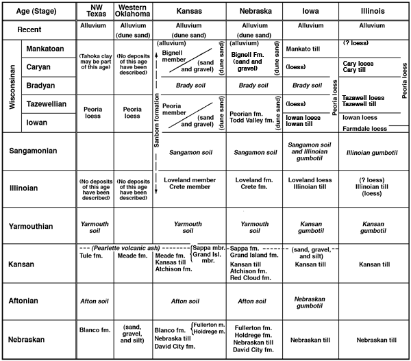
Figure 2--Chart showing proposed correlation of Pleistocene units in Kansas with principal described units in other states of the mid-continent region and the classic section of the upper Mississippi Valley region. A larger version of this figure is available.
Nebraskan Stage
The Nebraskan Stage includes the sediments genetically related to the first major cycle of Pleistocene glaciation and the deposits of equivalent age beyond the limits of glaciation. In Kansas these deposits are classed in three formations: the David City formation, the Nebraska till, and the Blanco formation (which includes the Holdrege and Fullerton members). Nebraskan sediments are distributed discontinuously over the State and are generally less well exposed than the succeeding stages. Nebraskan glacial sediments are exposed only in extreme northeastern Kansas, particularly in Doniphan County; chert gravels of this age occur as high terrace remnants along Cottonwood and Neosho Valleys in east-central Kansas; and Nebraskan alluvial deposits form the lower part of the fills of former valleys in central and southwestern Kansas. In the northwestern part of the State the Nebraskan Stage is virtually unknown.
Definition--The David City formation was described by Lugn in 1935 (pp. 38-40) from the records of sand and gravel with some silt and clay in wells near David City, Nebraska. In the type area the David City formation rests on bedrock, is overlain by Nebraska till, attains a maximum thickness of 150 feet, and is considered by Lugn (1935, p. 38) to be ". . . outwash fluvio-glacial material carried into old pre-Pleistocene valleys and other depressions on the bedrock in front of the Nebraskan glacier, and the inwash sediment carried by streams from other directions, whose valleys were dammed up by the ice itself or by debris washed from the melting ice sheet." Lithologically it has been described as resembling Platte River gravel, and as a fine- to medium-textured gray sand.
Character and distribution--The term David City formation is applied in Kansas only to water-laid deposits occurring below and genetically related to Nebraska glacial till. Its geographic distribution is therefore restricted to the three northeastern counties--Doniphan, Atchison, and Brown. It has been studied in surface exposures only along the Missouri Valley bluffs in Doniphan County and is best exposed in excavations in the NE SE sec. 6, T. 2 S., R. 20 E. At this locality, referred to as the "Iowa Point section" and described in the following measured section, 10 feet of sand, gravel, and cobbles which rest directly on Pennsylvanian limestone are overlain conformably by Nebraska till. The excavations also expose in ascending order Kansas till and the Loveland, Peoria, and Bignell members of the Sanborn formation (Frye and A. B. Leonard, 1949). The David City formation consists of cobbles (of pink quartzite, igneous and metamorphic rocks, and a predominance of limestones of several types) interbedded with sand and gravel (consisting predominantly of quartz grains but containing some grains of limestone and igneous and metamorphic rocks) and a small amount of silt. The entire thickness displays cross bedding and some of the well-sorted sand lenses in the upper part contain shells of small clams and several species of aquatic snails. Some shells have been collected at the contact with the overlying till, and the entire thickness of the formation is calcareous with local cementation by calcium carbonate.
| Iowa Point section, measured in quarry face and auger holes, NE SE sec. 6, T. 2 S., R. 20 E., Doniphan County, Kansas. | Thickness, feet |
||
| QUATERNARY--Pleistocene | |||
| Sanborn formation | |||
| Bignell silt member (Wisconsinan Stage, Caryan-Mankatoan Substages) | |||
| 7. Silt, massive, structureless, buff, gray, and tan; exposed in vertical face of quarry. Three to 4 feet at top and bottom partly leached of CaCO3 but containing some etched snail shells; remainder of interval effervescent in dilute HCl, fossiliferous. Upper half distinct faunally from lower half. | 38.0 | ||
| Peoria silt member (Wisconsinan Stage, Iowan-Tazewellian Substages) | |||
| 6. Silt, massive, structureless, gray and tan. Well-developed Brady soil at top, represented by a few feet gray leached silt, grading downward to a more compact zone, faint reddish-buff in color and locally containing abundant large caliche nodules in lower part; 12 to 15 feet thick. The lower 16 feet contains two weakly calcareous zones containing typical Peoria fossil snails, separated by a leached zone 2 feet thick. | 29.0 | ||
| Loveland silt member (Illinoian Stage) | |||
| 5. Silt, massive, reddish-buff. All but lower 0.5 foot leached and included in the Sangamon soil profile lower B horizon. Lower 0.5 foot calcareous. In adjacent exposures etched shells occur in the basal part of the Loveland. In contrast to the overlying loesses the Loveland displays a joint system with limonite concentrations along joints. | 7.5 | ||
| Kansas till (Kansan Stage) | |||
| 4. Till; matrix of clay and silt containing pebbles and cobbles of limestone, pink quartzite, and igneous rocks. Irregular masses of brown sand are incorporated in the till. Gray and yellow mottled. Lower 7 feet calcareous; upper 2 feet leached and containing nodules of caliche in lower part, judged to be the lower part of truncated Yarmouth soil profile. A few fossil snail shells found imbedded in the bottom few inches of Kansas till and sand. | 9.0 | ||
| Nebraska till (Nebraskan Stage) | |||
| 3. Till; matrix of clay and silt with pebbles and cobbles of limestone, igneous rocks, and a few of pink quartzite. Irregular masses of sand and gravel incorporated in till. At top a well-developed humic-gley Afton soil profile, darkened layer more than 2 feet thick and leached of all limestone pebbles to a depth of more than 3 feet. Quartzite pebbles occur throughout soil. The dark layer grades downward into a medium-gray to light-brown leached and oxidized zone, which in turn grades downward into gray calcareous till. A few fossil snail shells found imbedded in bottom few inches of till. | 7.0 | ||
| David City formation (Nebraskan Stage) | |||
| 2. Gravel, cobbles, boulders, sand, and silt; limestone, igneous rocks, and quartzite, moderately well-sorted sand common in upper part, iron-stained, calcareous; locally cemented with CaCO3, local concentrations of fossil snail shells and small clams in well-sorted sands in the upper part. | 10.0 | ||
| PENNSYLVANIAN--Virgilian | |||
| Deer Creek limestone and Calhoun shale | |||
| 1. Limestone and shale exposed in quarry face to level of Missouri River flood plain. Approximately | 30.0 | ||
| Total thickness exposed | 130.5 | ||
Nonglacial gravels judged to be pre-Nebraskan in age occur at this same stratigraphic position in northeastern Kansas (Todd, 1920; Frye, 1941). These pre-glacial gravels consist entirely of chert and limestone pebbles, obviously derived from cherty limestones within 100 miles west of Missouri River, and a minor amount of quartz sand. Unlike the David City gravels, from which they are readily distinguishable, these pre-glacial gravels are totally lacking the rock types indicative of a northern or northeastern glacial source.
Topographically the David City occurs in contact with bedrock more than 30 feet above the level of the Missouri River flood plain whereas the pre-glacial gravels, at all localities known in this area, occur on higher bedrock.
Test drilling in northeastern Kansas (Frye and Walters, 1950) has failed to reveal this formation beyond the limits of Doniphan County although the overlying Nebraska till may extend into adjacent Brown and Atchison counties. The David City formation is quantitatively a minor element of the Pleistocene deposits in Kansas.
Age and correlation--The David City formation in Kansas is considered to be early Nebraskan in age and equivalent to the subsurface type in Nebraska because it is lithologically similar to the overlying Nebraska till with which it is conformable. It is strongly dissimilar to the nonglacial gravels in a comparable stratigraphic position. The David City gravels were deposited during the advance of the Nebraskan glacier, but were subsequently overridden by the advancing ice mass. Locally, age equivalents to the David City may be included within the Blanco formation in southwestern Kansas, but if so, are not recognizable.
Definition--In the last decade of the past century the existence in southern Iowa of a till below the one now called Kansas became well established. This earliest Pleistocene glacial unit was variously called Kansan, pre-Kansan, sub-Aftonian, Albertan, and Jersyan. The typical description of this earliest glacial deposit was based on exposures in Union County, Iowa. In 1909 Shimek proposed the name Nebraskan for this drift because he concluded that it extended westward into the State of Nebraska and subsequently this name has been generally accepted in the Missouri Valley and upper Mississippi Valley regions. The Nebraska till is the earliest recognized glacial deposit in Kansas. It comformably overlies the David City formation and is overlain unconformably by Kansas till.
Character and distribution--Nebraska till has been recognized with certainty only in Doniphan, Atchison, and Brown counties in the extreme northern part of the State, and surface exposures are restricted to the Missouri Valley bluffs in Doniphan and Atchison counties. Evidence has been cited for the presence of Nebraska till along Kansas River Valley east of Lawrence (Schoewe, 1927) and this suggests the possibility that another lobe of Nebraskan ice crossed the present site of Missouri River between Kansas City and Leavenworth. Test drilling in the glaciated area (Frye and Walters, 1950) has not been sufficient to settle this question but it is adequate to restrict clearly such a lobe--if it did exist--to a relatively small area in Leavenworth County and the Kaw Valley to the south of that county.
Where it has been studied in outcrop sections the Nebraska till is indistinguishable lithologically from the much more widespread overlying Kansas till. It consists of boulders and cobbles of pink quartzite, conglomeratic quartzite, igneous rocks, metamorphic rocks, and predominantly limestone, in a matrix of clay, silt, and sand. Where unweathered it is calcareous and gray in color. It commonly contains lenses and zones of well-sorted sand. Its recognition is based on the stratigraphic relationship which is demonstrated conclusively in exposures at the Iowa Point section (Frye and A. B. Leonard, 1949) in Doniphan County (NE SE sec. 6, T. 2 S., R. 20 E.). At this locality the Nebraska till, 7 to 10 feet thick, is characterized by a well-developed Wiesenboden, or humic-gley, Afton soil in the upper part. Although part of the A horizon of the Afton soil was removed by the overriding Kansan glacier, most of its thickness is preserved and is not distorted by later glacial scour or by frost action. The upper 2.5 feet is darkened by organic material and is leached of carbonates including limestone pebbles, although quartzite pebbles occur sparsely throughout its thickness. The dark-gray to black zone grades downward into a less intensely weathered gray-tan zone which in turn is gradational with calcareous till containing limestone pebbles in the lower part of the exposure. The Afton soil at this locality is similar in appearance to material called Nebraskan gumbotil in Iowa and Nebraska.
Thin Nebraska till may occur locally below the Atchison formation southwest of the City of Atchison (Frye, 1941). In this area, however, Afton soil has not been found in the top of the Nebraska till.
Although test drilling in northern Atchison County and Doniphan and Brown counties has not been adequate to furnish the desirable details (Frye and Walters, 1950) it is judged that Nebraska till is discontinuous under the Kansas till in this area, occurring on relatively high bedrock surfaces. Nebraska till was not recognized in test holes south of the prominent bedrock sag trending east-west through southern Nemaha County, or west of Brown County.
Age and correlation--There is no inherent characteristic of the Nebraska till that permits its correlation with the type to the north. Rather, its correlation rests on its stratigraphic position and regional relationships to the north and northeast. Detailed work in that region (Kay and Apfel, 1929; Kay and Graham, 1943; Condra and Reed, 1950) has shown that only two major glacial advances approached Kansas. The presence of the well-developed Afton soil, which demands a significant interval of time for its development, separating two tills in northeastern Kansas requires the correlation of the lower till of this area with the Nebraska till of the type area.
Definition and subdivisions--The name "Blanco Canyon beds" was first used by Dumble (1890) and by Cummings (1891). The exposures along Blanco Canyon of White River north of Crosbyton, Crosby County, Texas, and the vertebrate fossils from these deposits have also been discussed by Gidley (1903), Osborn (1903), Baker (1915), and Matthew (1925). Recently the Blanco beds have been described in detail by Evans and Meade (1945, pp. 491-493) and the contained fossil vertebrates have been discussed by Meade (1945). Typical exposures of the Blanco formation occur near Mt. Blanco, near the juncture of Crawfish Draw with Blanco Canyon, approximately 10 miles north of Crosbyton, Texas. Here the Blanco formation consists of gravel and sand in the lower part, with gray to white silts, sands, and clays with some diatomaceous marl and fresh-water limestone in the upper part. The formation is unconformable on Pliocene Ogallala formation. The contact truncates the Ogallala beds at a low angle and abraded pebbles and cobbles of Ogallala "cap rock" locally form the lower few feet of the Blanco.
In the upper part of the Blanco, nodular caliche which is judged to represent the buried Afton soil commonly occurs in a zone ranging up to 2 feet in thickness. Sand, silt, and volcanic ash unconformably overlie the Blanco in this area. The volcanic ash has been determined on the basis of petrographic characters to be the Pearlette bed (Frye, Swineford, and Leonard, 1948). The Pearlette ash commonly occurs in the Tule formation in this region of the Texas High Plains. It has associated with it fossil vertebrates and a large molluscan fauna, features which serve to establish correlation of the Tule formation with the Sappa member of the Meade formation in Kansas and the Sappa formation in Nebraska.
In Kansas, as in other areas of the Great Plains, deposits correlated with the Blanco formation commonly are coarse-textured in the lower part and grade upward into finer-textured elastics. Although conformable and gradational these contrasting lithologies merit recognition as named members. In Nebraska, equivalent units are named Holdrege and Fullerton formations (Lugn, 1935; Condra and Reed, 1950); in Kansas these names are used to designate the comparable members of the Blanco formation.
The name Holdrege formation was applied in Nebraska to sands and gravels reported in the log of a test well drilled for oil near the Cen. SW sec. 23, T. 6 N., R. 19 W., 2 miles north and 4 miles west of the City of Holdrege, Phelps County, Nebraska (Lugn 1935, p. 92). This test is reported to have penetrated 71 feet of Holdrege sand and gravel resting on 129 feet of Tertiary Ogallala formation and overlain by 30 feet of Fullerton formation silts, sandy silts, and clays.
The Fullerton formation was described and named from exposures about 1 mile northwest of Fullerton, Nance County, Nebraska (Lugn, 1935, pp. 83, 98). The Fullerton silts, here 20 feet thick, occur as the lowest exposed unit of the Fullerton, or "Lover's Leap" section. This section exposes Peorian and Loveland loesses, Crete formation, Sappa formation, Grand Island formation, and Fullerton formation (Nebraska classification). Holdrege formation sand and gravel below the Fullerton has been penetrated in near-by wells. Lugn (1935, p. 98) states that although the Fullerton formation is exposed only at the type locality and in the northern part of Nebraska, it is known from subsurface data to occur over a wide area.
Character and distribution--In Kansas the Blanco formation is quantitatively important only in the central and southwestern parts of the State (Pls. 1, 2). The Blanco formation is unknown in the glaciated area except for a few small and inconclusive deposits of chert gravels which contain a minor percentage of pebbles common to the glacial deposits (Davis, 1951).
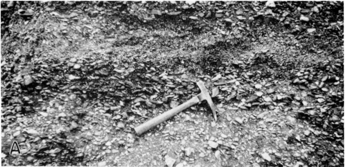
In east-central Kansas thin deposits of chert gravels that occur on disconnected high terrace remnants are judged to be age equivalents to the Blanco formation. These gravels consist entirely of siliceous grains, ranging in size up to several inches in diameter, that are similar to the chert contained in the upper Pennsylvanian and lower Permian rocks of east-central Kansas and the Flint Hills belt. No pebbles that could not have been derived from the Permian Herington limestone and rocks occurring stratigraphically lower have been found in these deposits. It is obvious that the source of these gravels (Pl. 3A) is quite local. The red clay matrix which fills the interstices of these gravels and the absence of limestone pebbles demonstrate that they have been subjected to prolonged weathering. In most exposures examined this red clay matrix persists through the entire thickness of the gravel and might be classed as the over-thickened B horizon of an ancient soil.
Plate 3A--Blanco formation. Chert gravels capping high terrace remnant and assigned to Blanco formation; NW sec. 5, T. 19 S., R. 12 E., Lyon County (1949).
These terrace deposits are considered to be equivalent to the Blanco formation because of the advanced degree of weathering and their physiographic setting. A persistent terrace, called the Emporia terrace by H. G. O'Connor (personal communication) and dated as late Kansan by the presence of Pearlette volcanic ash, occurs at a height of 35 to 40 feet above the flood plain. The Emporia terrace gravel consists predominantly of chert but contains in the lower part a significant percentage of limestone pebbles and in the upper part a red clay zone. The Nebraskan age terrace remnants occur at a height of 75 to 105 feet above flood plain level along this same valley system. Chert gravels in this terrace are well exposed in several quarries (for example: northwest of the City of Emporia, and in the NE sec. 5, T. 19 S., R. 12 E., Lyon County; SW sec. 13, T. 19 S., R. 8 E., Chase County). Remnants of a still higher terrace, veneered with chert gravels indistinguishable lithologically from the Nebraskan gravels, occurring at heights of 150 to 200 feet above the same flood plains, are judged to be late Tertiary in age.
Terrace gravels of the same lithologic type which may also be Nebraskan in age occur adjacent to Elk River (for example: in the NW sec. 13, T. 31. S., R. 11 E. and sec. 12, T. 30 S., R. 10 E., Elk County), Fall River (well exposed at right end of Fall River Dam), and Marais des Cygnes River.
In central Kansas the Blanco formation has been described by Fent (1950, pp. 64-65) who proposed the name Chase Channel formation, containing Holdrege and Fullerton members, for these deposits in Rice County. The log of a test hole through the formation is given below. In this area the formation is known primarily from test hole data. It forms the lowest part of the fill of buried valleys such as Chase channel, which are cut more than 200 feet below adjacent uplands capped with remnants of Pliocene Ogallala formation. Here the Holdrege gravels consist predominantly of locally derived rocks and grade upward into tan silts with soil caliche in the upper part. The Blanco is overlain by the late Kansan Meade formation which contains, at the site of some test holes, the Pearlette volcanic ash bed.
| Log of Kansan and Nebraskan sediments penetrated in a test hole drilled in the filled Chase channel, SW SE sec. 10, T. 20 S., R. 9 W., Rice County, Kansas (Fent, 1950, p. 128). | Thickness, feet |
Depth, feet |
||
| QUATERNARY--Pleistocene | ||||
| Post-Kansan sediments | 70 | 70 | ||
| Meade formation (Kansan Stage) | ||||
| Sappa member | ||||
| Silt, calcareous, light-tan, and white clay; contains much volcanic ash | 9 | 79 | ||
| Volcanic ash (Pearlette bed), white; contains a few fine quartz grains | 5 | 84 | ||
| Sand, very fine, and silt, light-gray; contains many shell fragments | 30.5 | 114.5 | ||
| Grand Island member | ||||
| Sand, fine to medium | 11.5 | 126 | ||
| Blanco formation (Chase Channel formation of Fent) (Nebraskan Stage) | ||||
| Fullerton member | ||||
| Silt, calcareous, light-gray | 14 | 140 | ||
| Silt, buff, and fine sand | 10 | 150 | ||
| Holdrege member | ||||
| Sand, medium to fine | 16 | 166 | ||
| Gravel, fine to coarse, and sand | 10 | 176 | ||
| Silt, calcareous, buff; contains much coarse to fine sand | 2 | 178 | ||
| Gravel, fine to coarse, and sand | 12 | 190 | ||
| PERMIAN--Leonardian | ||||
| Harper sandstone | ||||
| Siltstone, dark-red | 4 | 194 | ||
South and southeast of Rice County in central Kansas the Blanco formation crops out along the valleys of Arkansas, Chikaskia, and Ninnescah Rivers in Harper, Kingman, Reno, and Sedgwick counties. In this area the Blanco is thin and the Holdrege gravels are comparable to the deposits of the filled valleys in Rice County in that they consist largely of rocks derived from bedrock formations that occur to the north and west in central Kansas. An exposure of Holdrege gravel resting on Permian occurs in a road cut in the SW sec. 6, T. 27 S., R. 7 W., in northern Kingman County. Here these gravels consist predominantly of pebbles of Cretaceous rocks but also contain chert, some quartzite, and a few granitic pebbles. Gravels have been traced by test drilling northward from this locality across Reno County to an area where they occur incised below Ogallala (oral communication from O. S. Fent).
The strong reflection of local source in the lithology of the Holdrege gravels is clearly shown by the northward tracing of these deposits into northern Barton County and westward along the Smoky Hill Valley. In the vicinity of Galatia in northern Barton County and in adjacent southwestern Russell County (Latta, 1950) Holdrege gravels occur on a gentle sag on the Arkansas-Smoky Hill River divide high above the Kansan terrace of the Smoky Hill Valley. Here they contain a significant percentage of granitic pebbles. Farther north, on the north side of the Smoky Hill River, they are exposed in a similar topographic position in an abandoned pit and road cut about 1 mile northeast of Gorham in Russell County, several miles to the west in Ellis County, and at Antonino in southern Ellis County. At these localities the Holdrege gravels resemble the gravels of the Ogallala formation which occurs nearby at higher elevations. In sharp contrast, the Holdrege gravels in central Ellis County, in a tributary position to the major Nebraskan streams and deriving their sediment principally from the Fort Hays limestone (Cretaceous, Niobrara formation) escarpment, consist largely of pebbles of chalk.
As the direction of flow of the major Nebraskan streams was north-northwest to south-southeast whereas the principal stream now flows east-southeast across Rice, Reno, and western Sedgwick counties (Pl. 2), the topographic position of the Holdrege rises eastward across this area. In eastern Harvey and Sedgwick counties thin Blanco deposits cap the low scarp along the east side of the Arkansas alluvial plain and in southern Sedgwick County they cap the relatively low upland west of Arkansas River Valley where the major stream swings toward the south-southeast. Exposures are meager in this slightly dissected upland but the Fullerton member is well exposed in the SW SW sec. 16, T. 27 S., R. 2 W., Sedgwick County, where 8 feet of gray to greenish-gray silt and sand rests on Permian shale exposed along a cut bank of Dry Creek. Here the Fullerton is overlain by red sandy silts and silty sands tentatively classed as Crete-Loveland. The upper 3.5 feet of the Blanco contains a heavy accumulation of nodular caliche judged to be the combined results of Afton and Yarmouth soil development, but the A horizon and the upper part of the B horizon have been removed by erosion. The silts below the caliche zone contain abundant fragments of snail shells but few identifiable shells are to be found. In this area the contact of Blanco on Permian is more than 200 feet higher than the bedrock floor under the Arkansas Valley no more than a mile to the east.
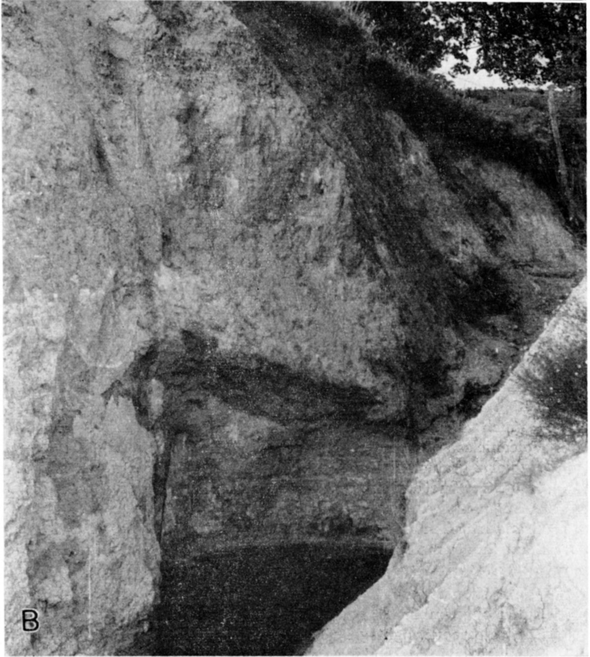
South of Great Bend in Stafford and Pratt counties the Blanco formation forms the lowest part of the fill in valleys now overlain by sediments of Kansan, Illinoian, and Wisconsinan ages. The formation is here known primarily from test hole data (Pl. 2). In the southern part of Kingman County and northern Harper County, however, dissection by Chikaskia River and adjacent streams affords more ample exposures. In the SE SW sec. 12, T. 29 S., R. 8 W., Kingman County, Blanco deposits are well exposed in a road-side gully (Pl. 3B). Here pink-tan silty clay and gray sand and silt with a heavy nodular caliche zone in the top occur in an erosional valley in the Permian cut below the level of adjacent contact of Kansan deposits on Permian. This exposure has yielded a large fauna of fossil mollusks.
Plate 3B--Blanco formation resting on erosion surface on Permian and overlain, in adjacent exposures, by Grand Island member of Meade formation. Large molluscan fauna collected from the upper part of this exposure. SE SW sec. 12, T. 29 S., R. 8 W., Kingman County (1951).
A comparable exposure of Blanco occurs along road cuts in the SW sec. 35, T. 31 S., R. 10 W., northern Barber County. At this locality partly cemented fine sands, silts, and sandy silts, gray and gray-green, occur on the Permian surface below the level of extensive Grand Island gravels (Meade formation) to the north. Nodular caliche occurs in the upper part and fragments of fossil snail shells are scattered throughout the exposure.
Quantitatively the Blanco formation has its maximum development in Kansas in the southwestern area, where the formation attains a maximum thickness of more than 250 feet. In this area Smith in 1940 (p. 95) described and named the Rexroad formation from exposures (now classed as Blanco formation) on the Clarence Rexroad ranch in sec. 22, T. 33 S., R. 29 W., Meade County. In 1941 Frye and Hibbard (p. 407) redescribed these beds as the Rexroad member of the Ogallala formation. They state concerning these deposits in central Meade County (Frye and Hibbard, 1941, pp. 407-408):
. . . the thickness and character of the member are known only from testhole samples and well logs. Where the entire member is present it is about 200 feet thick, but in the deepest part of the basin it may attain a maximum thickness of 250 feet, and east of the Crooked creek fault it is only about 30 feet thick. On the basis of data from test holes, the lower 175 feet of the Rexroad member may be described as comprising alternating beds of sand, silt, and clay. . . . Two well-defined snail zones were encountered in the test drilling. . . .
The upper beds of the Rexroad member, which are exposed at the surface, consist of blue-gray, tan, and gray sand, silt and clay. At many places a bed of soft sandy caliche occurs at the top of the member and at a few localities a thin bed of peat occurs 20 to 30 feet below the top. The Rexroad member of the Ogallala formation is overlain unconformably by the basal sand or gravel of the Meade formation of Pleistocene age.
The anomalous overthickened Blanco deposits in central Meade County are the result of post-Ogallala, pre-Nebraskan movement along the Crooked Creek fault (Frye, 1942) which extends in a south-southwesterly direction across central and southern Meade County into Beaver County, Oklahoma. Blanco deposits in southwestern Kansas occur principally in the area west of the Crooked Creek fault and east of a prominent fault revealed by test drilling in Stanton, Hamilton, and Kearny counties (Latta, 1942; McLaughlin, 1943). These sediments extend northward across Arkansas Valley and into the "Scott-Finney depression" (Latta, 1944; Waite, 1947) of northern Finney County and north through central Scott County (Pl. 1).
Throughout southwestern Kansas the Blanco formation closely resembles the Ogallala formation lithologically, having been derived in large part from those Pliocene sediments. In general it contains sands and gravels in the lower part, grading upward into reddish-tan sandy silts and silts which contain nodular caliche. In this region the Blanco, known almost entirely from subsurface data (Frye, 1942; Latta, 1944; McLaughlin, 1946; Byrne and McLaughlin, 1948) is exposed along Crooked Creek Valley in central Meade County and Cimarron River Valley in southwestern Meade County, Seward County, and southern Grant County. The upper part is well exposed at the Rexroad type locality where it has yielded large faunas of fossil mollusks and vertebrates (Hibbard, 1944), in several road cuts west of the City of Meade, in Wolf Canyon and adjacent canyons south of Cimarron River in southwestern Meade County where it has yielded both fossil mollusks and vertebrates (Hibbard, 1944, 1944a, 1949b, 1950, 1951) and along canyon walls on the north side of Cimarron River Valley in southwestern Meade County where fossil vertebrates have been collected.
Age and correlation--The placement of the Blanco formation within the standard time scale has been a question for debate among vertebrate paleontologists for many years. Suggested correlations, based on fossil vertebrates, have been made with other localities of fossil vertebrates in North America and Europe and not with the glacial time scale of the Mississippi Valley--although some writers have referred to the glacial age terms. General agreement seemingly exists among paleontologists concerning the similarity of faunas classed as Blancan in Texas, Kansas, and Nebraska. Early in the present century the Blanco beds were considered to be middle Pliocene in age (Matthew, 1925) and a decade ago they were placed as late Pliocene (Wood and others, 1941; Hibbard, 1937b, 1941a, 1941b; Frye and Hibbard, 1941). Recently (McGrew, 1944; Evans and Meade, 1945; Meade, 1945; Schultz and Stout, 1941, 1945, 1948) evidence from fossil vertebrates has been cited in support of an early Pleistocene (Nebraskan or Aftonian) age for the same localities in the three states.
The lack of fossil vertebrates in the glaciated region has prevented correlations with the glacial sequence based on vertebrate evidence. Therefore assignment of age to the Blanco and its equivalent was based on correlation with fossiliferous beds in southern Europe. Evidence has been presented that the Blancan faunas are equivalent in age to the fauna of the Villafranchian (McGrew, 1944, p. 47; Stout, 1950) or Villafranchian and Astian (G. G. Simpson, 1947, p. 623) or the Calabrian which is judged to be equivalent to Villafranchian (Schultz and Stout, 1948) of southern Europe. As the International Geological Congress which met in London in 1948 expressed unanimity (Moore, 1949; Oakley, 1950, p. 6) concerning the placement of the Calabrian (Villafranchian) as earliest Pleistocene it seems evident that the Blanco formation should be classed as early Pleistocene.
Since the Pleistocene time scale generally accepted as standard in interior North America is based on the sequence of glacial deposits, it is more significant to our problems to examine the evidence establishing correlation with the glacial section. Three independent kinds of evidence, exclusive of fossil vertebrates, demonstrate that the Blanco formation in central and southwestern Kansas and in northwestern Texas, is a product of the Nebraskan cycle of deposition and should be classed within the Nebraskan Stage. These are (1) the contained fossil mollusks, (2) stratigraphic framing between the conclusively correlated Sappa member of the Meade formation above (based on Pearlette volcanic ash, fossil mollusks, buried soil, and physiographic position) and the Pliocene Ogallala formation below, and (3) regional physiographic history.
Fossil mollusks occur abundantly in the Blanco formation in southwestern and central Kansas, as well as in Nebraskan sediments (David City formation and Nebraska till) at the Iowa Point section in the glaciated region of Kansas. Of the species common to the glacial and nonglacial sections of Kansas, 5 species are restricted to the Nebraskan Stage and do not occur in the stratigraphically higher Kansan fauna (65 species, 29 localities) in the mid-continent region.
Stratigraphic framing is perhaps the most conclusive single line of evidence demanding a Nebraskan age for the Blanco formation. At the type locality and west of Channing, Texas, in central Meade County, Kansas, and in Rice County, Kansas, Blanco beds are overlain by the Meade formation (in Texas classed as Tule) including the Sappa member with the Pearlette volcanic ash bed, and at several localities an associated large molluscan fauna. At all of these localities unconformable relation of the Blanco to the Pliocene Ogallala formation is clear. The stratigraphic position of the Pearlette volcanic ash and associated fauna has been established in the glacial section of the Missouri Valley region (Kansas, Nebraska, Iowa, and South Dakota) as late Kansan or earliest Yarmouthian (Frye, Swineford, and Leonard, 1948). Furthermore, the unconformity at the top of the Ogallala and below the Blanco is of profound regional importance, representing an episode of erosion throughout the entire mid-continent region--the first such regional erosional unconformity after the initiation of Ogallala deposition. (Frye, 1948; Elias, 1948). These data establish the Blanco as the cycle of deposits next preceding the Kansan and following regional erosion after the culmination of Ogallala (Pliocene) deposition.
Physiographically the Blanco overlain by Kansan and younger sediments occurs in erosional channels cut more than 200 feet below the adjacent top of the Ogallala in central Kansas (Fent, 1950, 1950a); on the downthrown side of the Crooked Creek fault in Meade County in a position indicating more than 150 feet of post-Ogallala, pre-Blanco displacement (Frye, 1942); as high terrace remnants below adjacent Ogallala and more than 100 feet above Kansan sediments overlain by Illinoian gravels in a lower alluvial terrace along Smoky Hill Valley (A. R. Leonard, 1952); and as high terrace remnants above a Kansan terrace in east-central Kansas. Only a Nebraskan age will satisfy all these physiographic positions.
Aftonian Stage
The culmination of deposition of the Blanco formation may have extended into earliest Aftonian time and to that extent it might be assignable in its upper part (upper Fullerton member) to the Aftonian Stage. It is our judgment, however, that deposition of the Blanco was completed in the Kansas region by the time the Nebraskan ice sheet ceased to be active. If such were the case, a record of Aftonian time in Kansas is provided only by the Afton soil.
In the glaciated area a well-developed Wiesenboden or humic-gley soil (gumbotil) on Nebraska till and overlain by Kansas till has been studied only at the Iowa Point section. At this locality an exceptionally well-preserved soil, developed as a poorly drained profile, is exposed. The absence of limestone and granitic pebbles (common in the underlying till) from the upper part of the profile while quartzite pebbles occur throughout the old soil, attests to a long period of weathering.
Outside the glaciated region eroded remnants of Afton soil have been observed at localities in Kingman and Meade counties and northern Barber and Harper counties but an A or upper B horizon has not been observed. Eroded remnants of Afton soil have been penetrated in test drilling in Rice, Barton, Stafford, and Pratt counties. The eroded lower part of a composite soil that had its initial development in Aftonian time has been studied in the SW SW sec. 16, T. 27 S., R. 2 W., Sedgwick County, and in the NW sec. 36, T. 15 S., R. 26 W., Gove County, where nearly a complete profile underlies the surface of a dissected remnant of a high Nebraskan terrace. A soil that may be Afton and younger occurs below Peoria loess on eroded Ogallala in the SE NE sec. 33, T. 10 S., R. 28 W., Sheridan County.
In a wide region of the High Plains, particularly Greeley and Wichita counties and northern Hamilton, Kearny, and Finney counties, the depositional top of the Pliocene Ogallala formation is essentially uneroded and occurs under a cover of Wisconsinan loesses. In the many auger holes that have been bored through the loess in this region a heavy calcareous soil has been encountered at the top of the Ogallala. Soil-forming processes were operative on this surface for an undeterminable length of time after completion of Ogallala deposition and prior to Blanco deposition but it seems certain that Aftonian, Yarmouthian, and Sangamonian weathering all affected this surface.
Although data on the Afton soil are less adequate than for any of the succeeding Pleistocene buried soils, it seems probable that the degree of development of the Afton soil is comparable to the Yarmouth and Sangamon soils and is stronger than the Brady soil.
Prev Page--Geologic Processes || Next Page--Stratigraphy--Kansan Stage
Kansas Geological Survey, Pleistocene Geology
Comments to webadmin@kgs.ku.edu
Web version August 2005. Original publication date Nov. 1952.
URL=http://www.kgs.ku.edu/Publications/Bulletins/99/05_strat.html