![]()
Prev Page--Hydrometeorology and Hydrology || Next Page--Digital Simulation
Hydrogeology
Groundwater is the major, if not the sole, source of water for irrigation, municipal, and domestic uses in the study area. The major aquifer in the area consists of the alluvial and terrace deposits along the Pawnee River and its tributaries. The alluvial aquifer overlies the Dakota Formation and Greenhorn Limestone. The configuration of this bedrock surface, based on available drilling records, is shown in Figure 9.
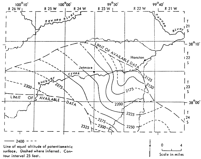
There is not much information related to the interaction of the unconsolidated and bedrock aquifers in the Pawnee Valley, especially on the relationship between the alluvial and Dakota aquifers. A piezometric map of the Dakota aquifer in the western part of the Pawnee Valley (Fig. 19) during 1973 (Lobmeyer and Weakly, 1979) shows the elevation of the piezometric surface to be less than the water-table elevation of the alluvial aquifer during 1979, indicating that there is not any potential gradient forcing water from the Dakota into the alluvium. [Note: Piezometric surface is an imaginary surface that everywhere coincides with the static level of the water in a confined aquifer.] However, the Dakota aquifer is hydraulically connected with the overlying alluvial aquifer in places where the Dakota aquifer directly underlies the alluvial aquifer.
Figure 19--Configuration of the potentiometric surface of the Dakota Formation, Hodgeman County, spring 1973.
Water-table Configuration and Decline
The configuration of the water table is shown in Figure 20. This map is based on mid-June 1979 water-level data collected during an extensive field survey of the area that yielded more than 170 data points. [Note: The 1979 water-level survey was supplemented and checked for questionable data using a January 1980 water-level survey. A suspect water-level depression indicated in the 1979 water survey in the area around Frizell was thus corrected. The water-level difference between the June 1979 and January 1980 water level surveys was within one to two feet on the average, not enough to make a difference on the water-level map (Fig. 20).] This is the only extensive water-level measurement survey since the one conducted by Fishel (1952) in 1945-47. The water-level survey published periodically by the U.S. Geological Survey (Water Resources Data for Kansas or other related reports) consists of only seven wells in the Pleistocene deposits of the Pawnee Valley in Pawnee County and 11 wells in the Pleistocene sediments in Hodgeman County. These are not sufficient for an adequate evaluation of the Pawnee Valley.
Figure 20--Water-table map of Pawnee Valley, Kansas, alluvial aquifer during 1979-1980.
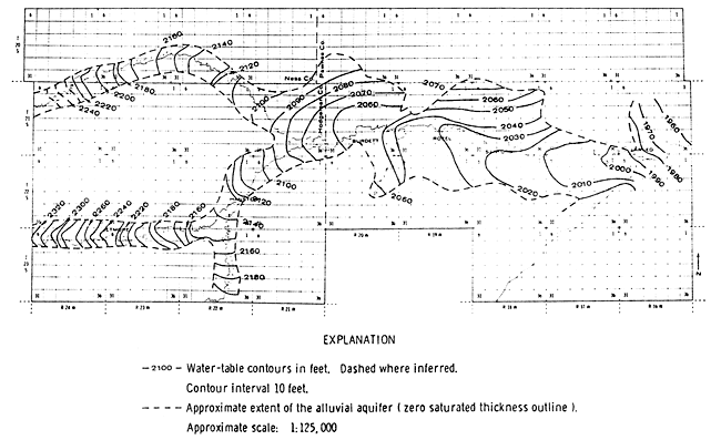
The water table, as shown in Figure 20, slopes generally to the east. The water-table contours bend upstream, indicating that groundwater is discharging into the streams. The hydraulic gradient varies inversely with distance between lines of equal head, in this case between water-table contours. Relatively uniform hydraulic conductivity gives rise to equidistant spacing of water-table contours. The variable contour spacing of the water-table map gives an indication of the variable hydraulic conductivity distribution over the alluvial aquifer. Movement of groundwater through intergranular spaces in porous materials is diffuse and fairly uniform, but the most permeable materials, such as sands and gravels, are commonly laid down by running water, and consequently have directional properties; the hydraulic conductivity in one direction may be many times greater than in another. Normally the horizontal components are greater than the vertical, but even these may vary greatly in direction and between individual sand layers in a single sand deposit. It is the varying hydraulic conductivities and the direction of greatest hydraulic conductivity that gives rise to the seemingly anomalous occurrences of groundwater, which has led to the belief in mysterious underground lakes and streams. In the Pawnee Valley, the deep valley has been eroded and filled with very permeable materials, and later deeply covered by less permeable material. This is a highly productive aquifer. Because of the relative scarcity of water on either side of the valley, it may be interpreted as an underground stream, which in a certain sense it is. However, the flow is through permeable materials and not through an actual channel-way as in a surface stream.
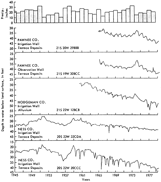
Figure 21 contains hydrographs of selected irrigation and observation wells in the study area, as well as the distribution of mean precipitation over the area. Water levels change with time depending upon the temporal variations in the balance between recharge and discharge. This balance is affected by both natural climatic variations and agricultural development. The response of water levels to local variations in climate is typified by the well hydrographs prior to the early 60s. The periods of water-level rise correspond to wet periods and declines correspond to dry periods. Water-level changes caused by agricultural practices have been superimposed on these natural fluctuations. Water-level declines since the mid-60s are the direct result of increased discharge from the aquifer to supply the consumptive use of irrigated crops.
Figure 21--Hyetograph and hydrographs for selected wells in Pawnee Valley.
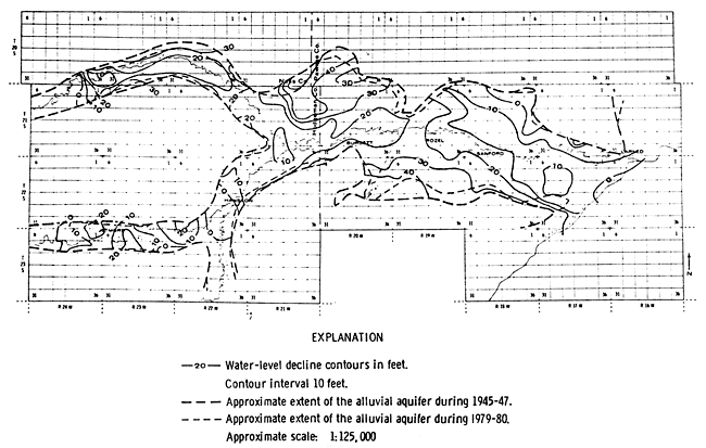
In order to evaluate the extent of these water-level declines, the 1945-47 water-level survey (Fishel, 1952) was used (see Fig. 22) in conjunction with the 1979-80 water-level map (Fig. 20). Based on these two maps, a 1945-47 to 1979-80 water-level decline map was produced (Fig. 23). Declines of greater than 30 feet are calculated for the area of the Pawnee Valley south of the Burdett-Rozel-Sanford area as well as for the area surrounding the Hodgeman-Ness-Pawnee county boundaries (Fig. 23). An approximate 15 percent shrinkage of the Pawnee Valley aquifer from 1945-47 to 1979, a result of increased pumpage, is indicated by the zero saturated-thickness contour outline.
Figure 22--Water-table map of Pawnee Valley, Kansas, alluvial aquifer during 1945-1947.
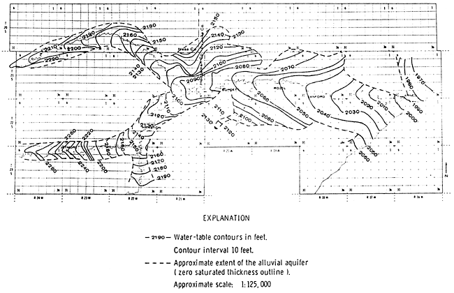
Figure 23--Water-level decline map of Pawnee Valley, Kansas, alluvial aquifer from 1945-47 to 1979-80.
Water in Storage
Groundwater is stored in the pore spaces of the unconsolidated deposits comprising the alluvial aquifer. The total volume of water stored at a given point in the aquifer is determined by the thickness and total porosity of the aquifer. Recoverable water in storage is determined by aquifer thickness, the amount of water that can be derived by gravity drainage, the expansion of water, and the compression of the aquifer matrix.
The saturated thickness of the Pawnee Valley alluvial aquifer ranges from zero along the edges of the valley to more than 80 feet near the center of the valley. Figure 24 is a saturated-thickness map as of 1979-80, and was constructed by contouring the difference between the water-table and the bedrock maps.
Figure 24--Saturated-thickness map of Pawnee Valley, Kansas, alluvial aquifer during 1979-80
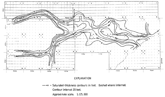
In order to study any possible reductions of water in storage since the 1945-47 (Fishel, 1952) survey, a new 1945-47 saturated-thickness map was constructed (Fig. 25). This map is somewhat different from the one published by Fishel (1952) because, in the construction of this saturated-thickness map, an updated bedrock map based on more data points than Fishel's was used. It should be noted that the 100- and 120-foot saturated-thickness contours in the 1945-47 map do not appear in the 1979-80 map, reflecting the increased use of groundwater.
Figure 25--Saturated-thickness map of Pawnee Valley, Kansas, alluvial aquifer during 1945-47
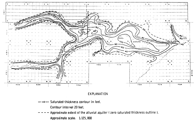
Table 9 compares the volume of water in the saturated deposits by county for 1945-47 and the present. These volumes were calculated by measuring the area between each pair of saturated-thickness contours using the planimeter method and then multiplying by the average saturated thickness. Assuming, as Fishel (1952) did, an average specific yield of 15 percent, the total volume of water available for pumping would be 15 percent of the volume of water-saturated deposits; these figures are also given in Table 9. From a practical standpoint, much less than this quantity of water would be available for irrigation use. An average depletion of water in storage of 37 percent is evident since 1945-47.
Table 9--Volume of water-saturated aquifer deposits in the Pawnee Valley. *Based on an assumed specific yield of 15 percent.
| County occupying portion of Pawnee Valley |
1945-47 volume of water in saturated deposits in acre-feet |
Maximum 1945-47 volume of water available for pumping in acre-feet* |
1979-80 volume of water in saturated deposits in acre-feet |
Maximum 1979-80 volume of water available for pumping in acre-feet |
Overall depletion of water from storage |
|---|---|---|---|---|---|
| Pawnee | 7,089,745 | 1,063,460 | 4,652,765 | 697,915 | |
| Hodgeman | 3,013,835 | 452,075 | 1,928,210 | 289,230 | |
| Ness | 1,043,715 | 156,555 | 442,570 | 66,385 | |
| TOTAL | 11,147,295 | 11,672,090 | 7,023,545 | 1,053,530 | 37% |
Comparison of the 1945-47 volume of water-saturated deposits reported here and that indicated in Fishel's report (1952) indicates a significant difference. This discrepancy is not due to planimeter errors but is the result of the following:
- A greater aquifer area is considered in this report than in the Fishel report;
- Because of the availability of more drilled well data since the Fishel report, a new bedrock map (Fig. 9) was constructed and the 1945-47 saturated thickness map was rederived (Fig. 25).
Aquifer Properties
In order to understand and analyze the operation of the hydro- geologic system of an area, an understanding of the hydrogeologic properties of the aquifer deposits is required. Those properties of greatest significance are the ability of the aquifer to transmit water, which is measured by the transmissivity or hydraulic conductivity of the aquifer material, and the ability of the aquifer to store or release water, which is measured by the storativity or specific yield of the aquifer. Very little information regarding these parameters is available for the Pawnee Valley area.
Fishel (1952) reported that the hydraulic conductivity of the alluvium in the Pawnee Valley was determined by five pumping tests. The results of those pumping tests were analyzed by the recovery method for computing the transmissivity of the aquifer and are summarized in Table 10. The variability of the aquifer material is demonstrated from these results. However, none of the reported pumping tests were designed or run long enough for a satisfactory calculation of the aquifer storativity.
Table 10--Results of Pumping Tests Made on Wells in the Pawnee Valley
| County | Well Location | Specific Capacity in gpm/ft |
Transmissivity in gpd/ft |
Hydraulic Conductivity in gpd/ft2 |
|---|---|---|---|---|
| Hodgeman | 21-21-21bc | 60 | 460,000 | 12,000 |
| Hodgeman | 21-21-35ba | 66 | 95,000 | 1,550 |
| Hodgeman | 21-21-35cc | 57 | 139,000 | 2,900 |
| Hodgeman | 22-22-23bc | 45 | 51,000 | 620 |
| Hodgeman | 23-22-11cc | 37 | 44,800 | 590 |
| Ness | 20-22-29cbb | 16 | 14,530 | |
| Ness | 20-22-23aab | 17 | 25,420 | |
| Ness | 20-23-23ccd | 44 | 44,390 | |
| Ness | 20-23-26cab | 6 | 9,700 | |
| Ness | 20-23-27dcb | 44 | 79,660 |
The report by Jenkins and Pabst (1977) on Ness County contains some specific-capacity data for wells in the Pawnee Valley portion of Ness County. High specific capacities usually indicate a high transmissivity and vice versa. The relationship between specific capacity and transmissivity is dependent upon the storage coefficient, the well diameter, and the duration of pumping. Walton (1970) presents the following relationship between specific capacity (Q/s) and transmissivity (T):
Q / s = [T / (264 log (Tt/(2693r2ws))-65.5)] (3)
where Q is the well discharge in gpm, s is the drawdown in feet, Q/s is the specific capacity in gpm/ft, T is the transmissivity in gpd/ft, s is the dimensionless storativity, rw is the nominal radius of the well in feet, and t is the time after pumping started in minutes. This equation was programmed in the computer to calculate T with the specific capacity Q/s, duration of pumping t, and well radius rw being known and an assumed storativity S of 0.15. The calculated transmissivities, T, are shown in Table 10.
Estimates of Regional Groundwater Recharge
There are several methods by which estimates of regional groundwater recharge can be made (Meyboom, 1966; Freeze, 1969), such as:
- Actual field measurements at the recharge end of the flow system;
- Interpretation of streamflow records at the discharge end of the flow system;
- The use of soil-moisture budgets based on hydrometeorological data;
- Calculation of quantitative regional flow by analytical or numerical model analysis.
In this report, the second and third methods have been employed to estimate groundwater recharge.
The long-term average recharge to the alluvial aquifer was assumed to equal the long-term average groundwater outflow during the early times of the Pawnee Valley irrigation development. According to Fishel (1952), during 1925 there were 35 irrigation wells in Pawnee Valley, while by 1945, the number of wells had increased to 132. The average annual baseflow during the period 1925 to 1945 was 5.04 cfs (3,651 aft/yr). Assuming that each irrigation well pumped about 90 aft of water per year, the average amount of groundwater pumped during that period was approximately 7,515 aft/yr. Making the further assumption that approximately 10 percent of that water returned to the aquifer by percolation (H. Dickey, 1979, oral communication), the net amount of pumpage during that period was 6,763 aft/yr. Thus, the total groundwater outflow (baseflow plus pumpage) for 1925 to 1945 was about 10,414 aft/yr, which--under the assumption of equilibrium--represents the amount of groundwater recharge. Groundwater outflow through evapotranspiration is presumed very small and therefore not considered in the calculations. As the area of the Pawnee Valley alluvial aquifer during 1945 (Fig. 22) was approximately 325 square miles, that quantity of recharge represents 0.60 inches per year over the aquifer area.
The second method for estimating regional groundwater recharge in the Pawnee Valley is the moisture-budget technique. Before the results of the soil-moisture budget analysis are presented, the basic concepts involved will be briefly discussed (Meyboom, 1966). A soil is saturated with water if all its interstices are filled. When the soil is permitted to drain freely, some water will be removed. This amount, expressed as a volume ratio, is called the specific yield of the soil. After gravitational water has drained out, the soil is said to be at field capacity. The moisture tension at field capacity is normally between 0.1 and 0.3 atmospheres. Field capacity is the upper limit of moisture available to plant life; the lower limit is reached at the wilting point, which corresponds to a moisture tension of about 15 atmospheres. The actual amount of moisture stored in the root zone between moisture tensions of 0.1 and 15 atmospheres depends mainly on the soil texture and is called the available storage capacity, or soil-moisture capacity.
Two concepts that are related to certain moisture conditions are relevant to the following discussion--soil-moisture deficit and soil-moisture surplus. Soil-moisture deficit is the amount of moisture that has to be added to a four-foot root zone to bring it to field capacity. A soil-moisture surplus exists when more moisture has been added to the root zone than the amount required to satisfy the transpiration demands of the vegetation and to bring the soil to field capacity. Thus, rain infiltrating the ground first meets the vegetation demands, and any excess thereafter can only pass below the root zone and eventually to the water table if the soil in the root zone is at field capacity. [Note: It should be recognized that the concepts of field capacity and permanent wilting point are vaguely defined concepts that do not represent unique, intrinsic physical properties, independent of the way they are measured. It has become increasingly clear that in a dynamic system, such as the soil, flow takes place almost incessantly, though in varying fluxes and directions, and static situations, as implied by the above static concepts, are exceedingly rare. However, such concepts are considered to provide a useful practical criterion for the upper and lower limits of soil water content that can be more or less depended upon in the field.] It is therefore possible to determine whether percolation will take place or whether it has taken place, by knowing the relationship among precipitation, actual and potential evapotranspiration, and antecedent soil-moisture conditions. This relation, which is generally presented in the form of a soil-moisture budget, can be calculated from meteorological records.
There are several techniques for calculating soil-moisture budgets. The technique used here is the Thornthwaite method for calculating potential evapotranspiration in conjunction with the modulated soil moisture technique devised by Holmes and Robertson (1959) to arrive at the actual evapotranspiration and moisture surplus and deficit. Table 11 presents the calculated average monthly moisture surpluses for the Larned and Jetmore stations, together with the frequencies at which surpluses occurred during 1959-1978. The table indicates that in the Pawnee Valley, and for the predominant soil-moisture capacity of 9.5 inches, moisture surpluses occur 15 percent or less of the time from January to March; five percent or less of the time during April, September, November, and December; and never during May, June, July, August, and October. Column 3 of Table 11 shows the total average moisture surplus, which constitutes potential groundwater replenishment. Column 4 shows the same amount as a percentage of the average total annual precipitation from 1959 to 1978. In the summary Table 12 as well as in Table 11, the moisture surplus for various soil-moisture capacities representative of Pawnee Valley soils is listed for the two meteorological stations mentioned previously. The soils map (Fig. 11) has been interpreted in terms of the percentage of the effective drainage area covered by soils representing each of the soil-moisture capacities (see Tables 3 and 8).
Table 11--Average monthly soil-moisture surplus (in.) for 1959-1978 calculated from year to year for different soil moisture capacities according to the modulated soil-moisture budget technique of Holmes and Robertson (1959) for two stations in the Pawnee Valley.
| Soil Moisture Capacity = 6.50 | ||||||||||||||||||||||||||
|---|---|---|---|---|---|---|---|---|---|---|---|---|---|---|---|---|---|---|---|---|---|---|---|---|---|---|
| Station | JAN | FEB | MAR | APR | MAY | JUN | JUL | AUG | SEP | OCT | NOV | DEC | Period | |||||||||||||
| 1 | 2 | 1 | 2 | 1 | 2 | 1 | 2 | 1 | 2 | 1 | 2 | 1 | 2 | 1 | 2 | 1 | 2 | 1 | 2 | 1 | 2 | 1 | 2 | 3 | 4 | |
| Larned, KS | 0.09 | 20 | 0.18 | 25 | 0.56 | 20 | 0.11 | 15 | 0. | 0 | 0.03 | 5 | 0. | 0 | 0. | 0 | 0.11 | 5 | 0. | 0 | 0.01 | 5 | 0.18 | 15 | 1.27 | 5.3 |
| Jetmore, KS | 0.07 | 10 | 0.07 | 15 | 0.48 | 15 | 0.08 | 10 | 0. | 0 | 0. | 0 | 0. | 0 | 0. | 0 | 0. | 0 | 0. | 0 | 0. | 0 | 0. | 0 | 0.70 | 3.3 |
| Soil Moisture Capacity = 8.50 | ||||||||||||||||||||||||||
| Station | JAN | FEB | MAR | APR | MAY | JUN | JUL | AUG | SEP | OCT | NOV | DEC | Period | |||||||||||||
| 1 | 2 | 1 | 2 | 1 | 2 | 1 | 2 | 1 | 2 | 1 | 2 | 1 | 2 | 1 | 2 | 1 | 2 | 1 | 2 | 1 | 2 | 1 | 2 | 3 | 4 | |
| Larned, KS | 0.19 | 15 | 0.10 | 15 | 0.40 | 15 | 0.07 | 5 | 0. | 0 | 0. | 0 | 0. | 0 | 0. | 0 | 0.04 | 5 | 0. | 0 | 0.01 | 5 | 0.12 | 10 | 0.94 | 3.9 |
| Jetmore, KS | 0.17 | 5 | 0.02 | 5 | 0.33 | 15 | 0.06 | 5 | 0. | 0 | 0. | 0 | 0. | 0 | 0. | 0 | 0. | 0 | 0. | 0 | 0. | 0 | 0. | 0 | 0.5 | 2.7 |
| Soil Moisture Capacity = 9.50 | ||||||||||||||||||||||||||
| Station | JAN | FEB | MAR | APR | MAY | JUN | JUL | AUG | SEP | OCT | NOV | DEC | Period | |||||||||||||
| 1 | 2 | 1 | 2 | 1 | 2 | 1 | 2 | 1 | 2 | 1 | 2 | 1 | 2 | 1 | 2 | 1 | 2 | 1 | 2 | 1 | 2 | 1 | 2 | 3 | 4 | |
| Larned, KS | 0.01 | 10 | 0.08 | 15 | 0.39 | 15 | 0.07 | 5 | 0. | 0 | 0. | 0 | 0. | 0 | 0. | 0 | 0.03 | 5 | 0. | 0 | 0.01 | 5 | 0.12 | 5 | 0.7 | 2.9 |
| Jetmore, KS | 0.00 | 5 | 0.02 | 5 | 0.28 | 15 | 0.06 | 5 | 0. | 0 | 0. | 0 | 0. | 0 | 0. | 0 | 0. | 0 | 0. | 0 | 0. | 0 | 0. | 0 | 0.36 | 1.7 |
Explanation of columns:
|
||||||||||||||||||||||||||
Table 12--Thornthwaite Potential Evapotranspiration and Holmes and Robertson (1959) moisture budget summary for two stations in the Pawnee Yalley.
| Station | Period for which Records Analysed |
Precip. (inches) |
Thornth. Potential Evapot. (inches) |
Holmes and Robertson Moisture Budget | |||||||||||
|---|---|---|---|---|---|---|---|---|---|---|---|---|---|---|---|
| Actual Evapotranspiration(inches) for various soil moisture capacities |
Moisture Surplus (inches) for various soil moisture capacities |
||||||||||||||
| 2.5 (in.) |
4.5 (in.) |
6.5 (in.) |
8.5 (in.) |
9.5 (in.) |
10.5 (in.) |
2.5 (in.) |
4.5 (in.) |
6.5 (in.) |
8.5 (in.) |
9.5 (in.) |
10.5 (in.) |
||||
| Larned, KS | 1959-1978 | 24.15 | 32.11 | 21.20 | 22.59 | 23.11 | 23.70 | 23.79 | 23.88 | 2.95 | 1.66 | 1.27 | 0.94 | 0.70 | 0.59 |
| Jetmore, KS | 1959-1978 | 21.15 | 31.96 | 19.29 | 20.37 | 20.76 | 21.09 | 21.15 | 21.20 | 1.89 | 0.90 | 0.70 | 0.57 | 0.36 | 0.28 |
If 20 years of record (1959-1978) at the Larned and Jetmore stations are at all representative of the average conditions in the Pawnee Valley, moisture budgets indicate that the average potential annual groundwater replenishment in this watershed varies from 0.28 inches (soil moisture capacity 10.5 inches; Jetmore hydrometeorological conditions) to 1.27 inches (soil moisture capacity 6.5 inches; Larned hydrometeorological conditions). Or, in other terms, the potential annual recharge in this area lies between 1.3 and 5.3 percent of the average total annual precipitation. Tables 11 and 12 show that as the soil moisture capacity increases, the percentage of the available water that is actually evapotranspired increases at the expense of the moisture surplus. The actual evapotranspiration plus the moisture surplus should equal the precipitation amount; the small discrepancies in Table 12 are the result of the averaging of the budgeting procedure.
Applying the percentages of the effective drainage area covered by soils representing each of the soil-moisture capacities {Table 8) to the average moisture surplus over the basin for each soil-moisture capacity gives rise to an average annual surplus of 0.64 inches in the Pawnee Watershed. The moisture surplus must, however, satisfy the surface runoff as well as groundwater recharge. The average total runoff from the Pawnee Watershed, as measured at the gauging station west of Larned during 1959-78 for which the moisture budget is performed, is 0.267 inches (45.095 cfs). Of this, 0.022 inches (3.75 cfs) represents baseflow from groundwater discharge. Subtracting this from the total runoff yields a surface runoff value of 0.245 inches per year (41.34 cfs) over the effective watershed drainage area above the gauging station west of Larned (i.e., 2290 square miles). This figure, when subtracted from the average annual surplus, results in a value for regional groundwater recharge of 0.39 inches per year. This value is of the same order of magnitude as the one calculated from baseflow measurements.
Thus, the average estimated regional groundwater recharge for the Pawnee Valley is about 0.5 inches per year, which represents only 2.5 percent of the average annual precipitation. During 1978-79, the groundwater appropriations in the Pawnee Valley alluvial aquifer (which reached at least 84,000 aft) amounted to about eleven times the amount of estimated natural groundwater replenishment for the Pawnee Valley.
Hydrogeochemistry
The quality of the groundwater in the alluvial aquifer is believed to be generally acceptable for most uses. Very little information is available, however, on the alluvial aquifer water quality. There is only one well in the Pawnee Valley alluvial aquifer (22-19-10bbb) that is sampled yearly for chemical analysis. [Note: The Kansas Geological Survey is planning an extensive groundwater quality sampling program in the area for the summer of 1980.] Table 13 summarizes that water chemical analysis.
Table 13--Chemical analysis of groundwater collected on August 25, 1978 from a well 130 feet deep into Pleistocene deposits in Pawnee County (22-19-10bbb).
| Constituent | Chemical content, mg/l |
|---|---|
| Ca | 80 |
| Mg | 17 |
| Na | 65 |
| K | 5 |
| HCO3 | 310 |
| CO2 | 25 |
| SO4 | 48 |
| Cl | 73 |
| F | 0.9 |
| NO3 | 4 |
| N | 0.9 |
| P | 0.02 |
| SiO2 | 10 |
| Total dissolved solids | 456 |
| Alkalinity | 254 (as CaCO3) |
| Hardness | 270 (as CaCO3) |
| Sodium Absorption Ratio | 1.7 |
| Specific Conductance | 930 µmhos |
| pH | 7.3 |
| Temperature | 15.0°C |
Concluding Remarks
Not enough information to conduct a detailed hydrogeologic study of the Pawnee Valley is available at present. Detailed information related to the following items is not available:
- groundwater quality of the alluvial aquifer;
- extended water-level surveys over several years;
- streamflow water quality on a periodic basis;
- bedrock aquifers' water levels and quality;
- stream gauging of tributaries and streamflow gains and losses;
- hydrogeologic parameters of both alluvial and bedrock aquifers;
- amount of water pumped and period of operation of pumping wells;
- complete hydrometeorological data;
- surface-ground waters interaction studies and recharge mechanisms investigations.
However, best use has been made of all data in the limited time available. The results presented here are as accurate as the data available. Therefore, the general trends indicated by the available data and conclusions drawn from these are believed to be true representations of the hydrogeologic conditions in the Pawnee Valley.
Prev Page--Hydrometeorology and Hydrology || Next Page--Digital Simulation
Kansas Geological Survey, Hydrogeology
Placed on web Aug. 1, 2012; originally published April 1980.
Comments to webadmin@kgs.ku.edu
The URL for this page is http://www.kgs.ku.edu/Hydro/Publications/OFR80_6/04_geology.html