
![]()
Prev Page--Introduction, Study Area, Topography || Next Page--Hydrogeology, Hydrogeochemistry
Hydrometeorology
Precipitation and Temperature
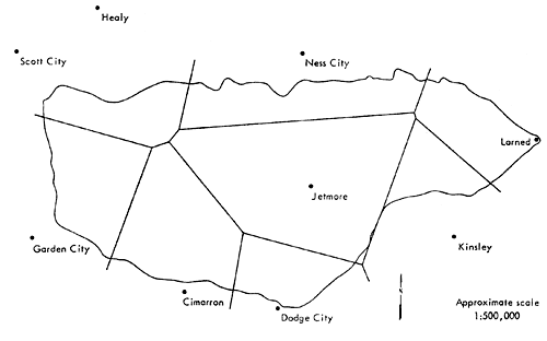
There are 13 meteorological stations in or near the Pawnee Watershed that have precipitation records of sufficient length and completeness for analysis. (U.S. Weather Bureau, Climatological data, Kansas section). The locations of these stations and the Thiessen polygonal subareas they cover are shown in Figure 12. The stations inside the watershed measure precipitation only or precipitation and temperature. There are only eight stations in or near the Pawnee Watershed that measure temperature. The location of temperature measuring stations and the Thiessen polygonal subareas they cover are shown in Figure 13.
[Note: A Thiessen network is constructed by connecting adjacent stations on a map by straight lines and erecting perpendicular bisectors to each connecting line. The polygon formed by the perpendicular bisectors around a station encloses an area which is everywhere closer to that station than to any other station. This area is assumed to be best represented by the precipitation at the enclosed station.]
Figure 12--Thiessen polygons for mean annual precipitation over the Pawnee Watershed.
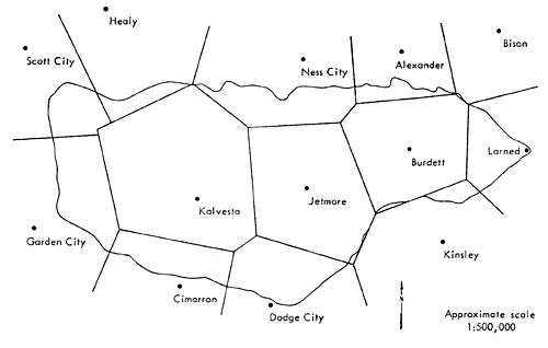
Figure 13--Thiessen polygons for mean annual temperature over the Pawnee Watershed.
The mean annual precipitation over the entire watershed for 1949-1978 was 20.5 inches, while the mean temperature for 1946-1978 was 55.2°F. The monthly precipitation and temperature records for the last 20 years (1959-1978) for the Larned and Jetmore stations are shown in Tables 4 and 5, respectively. The average annual precipitation for this period was 24.1 inches for the Larned station and 21.1 inches for the Jetmore station.
Table 4--Monthly precipitation and temperature for Larned, Kansas (1959-1978).
| Monthly precipitation (inches) | |||||||||||||
|---|---|---|---|---|---|---|---|---|---|---|---|---|---|
| JAN | FEB | MAR | APR | MAY | JUN | JUL | AUG | SEP | OCT | NOV | DEC | TOT | |
| 1959 | 0.53 | 0.75 | 1.66 | 0.76 | 5.03 | 2.71 | 4.14 | 1.32 | 2.86 | 4.42 | 0.14 | 0.71 | 25.03 |
| 1960 | 1.33 | 2.19 | 1.59 | 1.07 | 2.35 | 4.49 | 1.14 | 1.49 | 3.78 | 2.90 | 0.48 | 0.93 | 23.74 |
| 1961 | 0.02 | 0.44 | 1.94 | 1.51 | 5.03 | 4.95 | 4.60 | 7.00 | 0.74 | 1.52 | 1.71 | 0.35 | 29.81 |
| 1962 | 0.63 | 0.62 | 0.91 | 1.48 | 1.51 | 5.28 | 8.19 | 2.27 | 3.82 | 0.36 | 0.77 | 0.39 | 26.22 |
| 1963 | 0.22 | 0.84 | 1.01 | 0.08 | 2.06 | 4.75 | 4.81 | 1.51 | 4.08 | 0.70 | 0.28 | 0.38 | 20.72 |
| 1964 | 0.57 | 0.32 | 0.88 | 1.67 | 2.42 | 1.68 | 1.05 | 1.56 | 1.86 | 0.26 | 3.40 | 1.12 | 16.79 |
| 1965 | 0.63 | 0.97 | 0.34 | 1.61 | 4.05 | 7.83 | 2.83 | 6.28 | 5.50 | 2.32 | 0.02 | 2.94 | 35.32 |
| 1966 | 0.32 | 0.81 | 0.05 | 1.52 | 0.42 | 2.93 | 3.80 | 2.11 | 1.19 | 0.19 | 0.80 | 0.85 | 14.99 |
| 1967 | 0.28 | 0.01 | 0.17 | 2.96 | 1.94 | 7.47 | 2.12 | 3.53 | 3.90 | 0.38 | 0.31 | 0.90 | 23.97 |
| 1968 | 0.03 | 0.18 | 0.21 | 0.71 | 2.17 | 3.32 | 4.28 | 2.17 | 0.31 | 4.70 | 1.46 | 0.48 | 20.02 |
| 1969 | 0.08 | 1.81 | 2.27 | 2.58 | 3.91 | 2.07 | 1.49 | 4.62 | 3.49 | 2.49 | 0.14 | 0.14 | 25.09 |
| 1970 | 0.25 | 0.01 | 2.51 | 1.79 | 2.86 | 5.86 | 0.36 | 2.75 | 4.92 | 1.79 | 0.04 | 0.09 | 23.23 |
| 1971 | 0.81 | 2.41 | 0.23 | 2.52 | 2.95 | 2.24 | 5.72 | 2.57 | 1.36 | 3.34 | 4.90 | 0.79 | 29.84 |
| 1972 | 0.17 | 0.10 | 0.29 | 2.10 | 3.97 | 5.00 | 3.15 | 4.99 | 2.04 | 0.76 | 3.12 | 0.74 | 26.43 |
| 1973 | 0.53 | 0.38 | 7.70 | 3.06 | 1.58 | 0.51 | 5.09 | 3.18 | 11.15 | 1.96 | 1.23 | 2.43 | 38.79 |
| 1974 | 0.10 | 0.03 | 1.34 | 1.46 | 1.82 | 1.58 | 0.36 | 4.08 | 0.78 | 2.28 | 0.74 | 0.32 | 14.89 |
| 1975 | 0.50 | 1.13 | 1.24 | 1.58 | 4.44 | 3.24 | 0.71 | 3.67 | 1.26 | 0. | 1.61 | 0.52 | 19.90 |
| 1976 | 0.03 | 0.59 | 1.01 | 6.62 | 2.50 | 0.76 | 4.41 | 1.36 | 5.88 | 1.54 | 0.05 | 0.01 | 24.76 |
| 1977 | 0.84 | 0.02 | 1.67 | 2.27 | 4.04 | 3.09 | 3.22 | 4.90 | t.20 | 1.43 | 1.32 | 0.60 | 24.60 |
| 1978 | 0.27 | 1.35 | 1.03 | 0.32 | 4.64 | 4.01 | 1.46 | 1.21 | 2.39 | 0.17 | 1.68 | 0.29 | 18.82 |
| Mean monthly temperature (° F) | ||||||||||||
|---|---|---|---|---|---|---|---|---|---|---|---|---|
| JAN | FEB | MAR | APR | MAY | JUN | JUL | AUG | SEP | OCT | NOV | DEC | |
| 1959 | 26.10 | 34.40 | 46.00 | 54.20 | 67.20 | 77.20 | 76.20 | 80.00 | 68.90 | 4.00 | 41.00 | 39.50 |
| 1960 | 29.90 | 27.40 | 34.20 | 59.30 | 63.30 | 73.30 | 78.00 | 79.50 | 72.10 | 59.80 | 44.80 | 33.10 |
| 1961 | 33.60 | 38.80 | 45.00 | 52.90 | 63.20 | 74.00 | 78.90 | 75.30 | 65.00 | 58.40 | 40.60 | 29.40 |
| 1962 | 27.90 | 38.10 | 41.90 | 55.70 | 73.00 | 72.70 | 77.60 | 79.40 | 67.90 | 60.50 | 45.00 | 36.50 |
| 1963 | 22.40 | 41.00 | 49.80 | 60.00 | 69.10 | 77.00 | 85.00 | 82.10 | 74.30 | 68.50 | 47.60 | 27.40 |
| 1964 | 36.50 | 34.60 | 42.10 | 58.50 | 70.80 | 76.40 | 85.40 | 78.60 | 70.40 | 58.10 | 45.30 | 32.20 |
| 1965 | 34.90 | 33.30 | 35.80 | 59.50 | 68.10 | 73.70 | 80.30 | 78.00 | 65.70 | 60.10 | 49.20 | 38.00 |
| 1966 | 27.00 | 32.40 | 49.20 | 53.20 | 66.90 | 76.80 | 84.40 | 74.90 | 68.20 | 58.20 | 44.70 | 30.60 |
| 1967 | 34.90 | 38.40 | 50.10 | 59.40 | 63.30 | 74.30 | 75.30 | 75.40 | 67.30 | 59.40 | 43.50 | 35.50 |
| 1968 | 32.20 | 35.10 | 50.50 | 56.60 | 61.20 | 76.70 | 79.80 | 79.20 | 69.20 | 60.60 | 40.90 | 29.10 |
| 1969 | 30.70 | 35.20 | 35.40 | 57.10 | 65.70 | 71.90 | 82.90 | 77.40 | 70.50 | 53.70 | 44.90 | 35.00 |
| 1970 | 28.90 | 41.40 | 39.10 | 55.70 | 70.90 | 74.10 | 81.50 | 82.30 | 68.60 | 53.50 | 42.80 | 37.70 |
| 1971 | 28.70 | 31.60 | 44.30 | 57.40 | 63.60 | 78.50 | 78.80 | 77.00 | 69.80 | 59.40 | 45.00 | 36.20 |
| 1972 | 29.90 | 38.00 | 51.80 | 57.20 | 63.90 | 75.40 | 77.30 | 76.90 | 69.80 | 55.40 | 39.50 | 28.50 |
| 1973 | 30.20 | 37.80 | 47.10 | 52.60 | 63.70 | 76.90 | 79.60 | 80.00 | 65.60 | 60.50 | 45.50 | 32.30 |
| 1974 | 27.70 | 41.30 | 49.70 | 58.50 | 69.10 | 74.80 | 83.60 | 74.60 | 63.20 | 60.80 | 44.40 | 35.40 |
| 1975 | 35.30 | 31.00 | 40.90 | 55.40 | 65.80 | 73.80 | 79.50 | 81.10 | 67.40 | 61.20 | 44.10 | 38.10 |
| 1976 | 33.70 | 46.00 | 46.10 | 58.40 | 62.10 | 75.30 | 79.50 | 79.20 | 70.10 | 53.10 | 39.80 | 36.80 |
| 1977 | 24.50 | 36.10 | 49.40 | 58.80 | 69.80 | 78.20 | 83.40 | 77.70 | 73.10 | 60.80 | 44.40 | 35.20 |
| 1978 | 21.70 | 23.40 | 45.20 | 58.80 | 63.90 | 76.40 | 84.40 | 80.00 | 74.90 | 60.10 | 43.20 | 33.00 |
Table 5--Monthly precipitation and temperature for Jetmore, Kansas (1959-1978).
| Monthly precipitation (inches) | |||||||||||||
|---|---|---|---|---|---|---|---|---|---|---|---|---|---|
| JAN | FEB | MAR | APR | MAY | JUN | JUL | AUG | SEP | OCT | NOV | DEC | TOT | |
| 1959 | 0.61 | 0.46 | 1.24 | 0.26 | 4.20 | 2.66 | 2.93 | 1.17 | 2.04 | 4.16 | 0.74 | 0.68 | 21.15 |
| 1960 | 1.28 | 1.58 | 1.25 | 2.25 | 3.16 | 3.78 | 0.28 | 1.98 | 2.93 | 2.40 | 0.21 | 0.56 | 21.66 |
| 1961 | 0. | 0.23 | 1.08 | 1.68 | 2.77 | 5.41 | 4.24 | 6.97 | 1.69 | 1.06 | 2.11 | 0.33 | 27.57 |
| 1962 | 0.67 | 0.23 | 1.31 | 1.60 | 1.12 | 7.41 | 5.19 | 2.00 | 4.80 | 0.10 | 0.91 | 0.51 | 25.85 |
| 1963 | 0.45 | 0.68 | 0.56 | 1.86 | 3.26 | 2.52 | 2.01 | 1.22 | 2.83 | 2.53 | 0.67 | 0.42 | 19.01 |
| 1964 | 0.53 | 0.64 | 0.37 | 0.69 | 4.25 | 1.36 | 2.58 | 0.57 | 1.83 | 0.47 | 2.10 | 0.42 | 15.81 |
| 1965 | 0.78 | 0.62 | 0.17 | 0.47 | 4.55 | 5.27 | 2.64 | 3.40 | 1.84 | 2.76 | 0.03 | 2.05 | 24.58 |
| 1966 | 0.33 | 0.44 | 0.04 | 0.56 | 0.11 | 1.54 | 2.44 | 2.47 | 1.90 | 0.20 | 0.07 | 0 82 | 10.92 |
| 1967 | 0.27 | 0.68 | 0.42 | 1.90 | 3.88 | 4.47 | 1.50 | 1.83 | 1.03 | 0.34 | 0.20 | 0.51 | 17.03 |
| 1968 | 0. | 0.30 | 0.26 | 1.01 | 3.71 | 5.15 | 2.87 | 3.56 | 0.16 | 4.12 | 0.80 | 0.39 | 22.33 |
| 1969 | 0.08 | 1.16 | 2.00 | 3.11 | 3.73 | 2.03 | 4.68 | 4.53 | 0.92 | 3.45 | 0.16 | 0.15 | 26.00 |
| 1970 | 0.12 | 0.03 | 2.35 | 2.68 | 2.92 | 3.23 | 1.54 | 1.69 | 3.74 | 0.74 | 0.14 | 0.03 | 19.21 |
| 1971 | 0. | 1.93 | 0.26 | 1.80 | 4.52 | 3.46 | 3.38 | 0.88 | 1.30 | 2.41 | 2.29 | 0.55 | 22.78 |
| 1972 | 0.06 | 0.10 | 0.28 | 0.84 | 5.14 | 3.19 | 7.27 | 4.92 | 1.98 | 0.07 | 2.93 | 0.34 | 27 12 |
| 1973 | 0.58 | 0.36 | 9.04 | 2.74 | 1.09 | 0.24 | 4.58 | 4.31 | 4.64 | 1.60 | 0.70 | 2.02 | 31.90 |
| 1974 | 0.26 | 0.03 | 1.14 | 0.84 | 1.78 | 1.44 | 0.67 | 2.94 | 0.10 | 2.10 | 0.75 | 0.12 | 12.17 |
| 1975 | 0.21 | 0.76 | 0.71 | 2.40 | 3.74 | 3.41 | 0.12 | 2.18 | 0.43 | 0. | 1.80 | 0.20 | 15.96 |
| 1976 | 0.06 | 0.81 | 0.56 | 5.92 | 2.44 | 0.25 | 1.84 | 1.35 | 3.47 | 1.23 | 0.12 | 0.03 | 18.08 |
| 1977 | 0.50 | 0.02 | 0.54 | 3.37 | 2.82 | 1.70 | 3.17 | 9.57 | 0.63 | 2.01 | 0.32 | 0.48 | 25.13 |
| 1978 | 0.28 | 1.05 | 1.00 | 0.06 | 6.18 | 4.55 | 0.67 | 0.19 | 3.26 | 0.06 | 1.43 | 0.08 | 18.81 |
| Mean monthly temperature (° F) | ||||||||||||
|---|---|---|---|---|---|---|---|---|---|---|---|---|
| JAN | FEB | MAR | APR | MAY | JUN | JUL | AUG | SEP | OCT | NOV | DEC | |
| 1959 | 27.00 | 33.40 | 44.20 | 53.20 | 66.50 | 76.20 | 75.50 | 80.40 | 67.80 | 34.70 | 40.70 | 32.70 |
| 1960 | 28.40 | 26.10 | 35.70 | 59.20 | 63.00 | 73.70 | 77.80 | 78.50 | 71.00 | 59.60 | 43.80 | 33.70 |
| 1961 | 32.80 | 39.20 | 45.00 | 51.90 | 63.50 | 73.80 | 78.50 | 76.10 | 65.30 | 56.40 | 39.10 | 30.00 |
| 1962 | 27.40 | 38.40 | 41.80 | 54.70 | 72.00 | 71.50 | 77.60 | 79.20 | 68.20 | 60.40 | 45.00 | 37.70 |
| 1963 | 23.50 | 40.70 | 49.70 | 60.00 | 69.00 | 77.20 | 83.20 | 80.60 | 73.20 | 66.90 | 47.40 | 27.90 |
| 1964 | 36.80 | 33.70 | 42.00 | 58.50 | 70.40 | 75.10 | 83.80 | 78.70 | 70.20 | 57.90 | 45.30 | 32.90 |
| 1965 | 35.40 | 33.70 | 34.90 | 58.80 | 67.90 | 73.10 | 80.10 | 76.70 | 66.40 | 56.90 | 48.90 | 36.90 |
| 1966 | 26.90 | 31.90 | 47.60 | 53.20 | 66.40 | 77.00 | 84.70 | 75.10 | 68.50 | 57.70 | 43.00 | 29.80 |
| 1967 | 34.00 | 38.50 | 50.60 | 60.00 | 63.40 | 74.00 | 76.90 | 76.20 | 68.30 | 60.80 | 42.70 | 35.40 |
| 1968 | 33.00 | 35.40 | 49.40 | 56.20 | 60.90 | 76.?0 | 79.60 | 79.60 | 69.50 | 61.00 | 41.90 | 28.80 |
| 1969 | 34.70 | 35.90 | 34.20 | 57.60 | 66.60 | 71.30 | 82.30 | 78.90 | 70.90 | 53.10 | 44.80 | 34.80 |
| 1970 | 29.80 | 41.10 | 37.90 | 54.00 | 69.00 | 74.10 | 81.00 | 81.70 | 70.20 | 53.20 | 43.00 | 37.10 |
| 1971 | 30.60 | 32.20 | 43.90 | 56.10 | 63.60 | 78.40 | 79.00 | 76.80 | 70.40 | 60.10 | 44.70 | 36.70 |
| 1972 | 30.60 | 38.40 | 53.00 | 57.70 | 64.60 | 75.60 | 78.40 | 77.40 | 71.10 | 57.30 | 39.70 | 28.60 |
| 1973 | 30.80 | 38.10 | 47.70 | 52.30 | 63.70 | 76.70 | 80.30 | 81.30 | 66.80 | 58.70 | 44.60 | 34.80 |
| 1974 | 28.00 | 41.40 | 50.00 | 59.20 | 69.20 | 75.60 | 83.30 | 75.30 | 64.20 | 61.70 | 44.10 | 34.10 |
| 1975 | 36.30 | 32.40 | 42.60 | 56.10 | 65.70 | 74.00 | 79.30 | 81.60 | 68.60 | 61.40 | 43.10 | 38.70 |
| 1976 | 34.10 | 42.70 | 46.90 | 58.60 | 61.30 | 75.10 | 79.80 | 79.80 | 69.10 | 51.20 | 40.10 | 36.70 |
| 1977 | 25.30 | 36.10 | 48.20 | 59.20 | 69.50 | 79.80 | 84.00 | 78.50 | 71.80 | 60.90 | 42.80 | 36.80 |
| 1978 | 23.00 | 23.00 | 45.50 | 57.70 | 62.20 | 74.50 | 83.10 | 79.00 | 73.80 | 59.40 | 42.30 | 32.10 |
Evapotranspiration and Water-balance Diagrams
Evapotranspiration is the combined process of evaporation from free water and bare soil surfaces and transpiration by plants. Potential evapotranspiration is defined as the evapotranspiration that would occur from a vegetation-covered soil surface that is never short of water. Since moisture is never restricted, potential evapotranspiration is limited solely by available energy, primarily solar energy. If there is a shortage of moisture, actual evapotranspiration will fall short of potential evapotranspiration.
No direct measurements of evaporation or evapotranspiration are available in the Pawnee Watershed. As an approach to the problem of estimating potential evapotranspiration, the empirical method of Thornthwaite (1948) has been applied to the data of the stations at Larned and Jetmore, representing the two opposite ends of that part of the watershed studied in greater detail in this report. The minimum amount of meteorological data required for this method and its simplicity were the factors considered in choosing this method, although the results are only a rough approximation of evapotranspiration.
The formula developed by Thornthwaite for determining potential evapotranspiration from temperature data is:
E = 1.62 (10T/I)a (1)
where E is the monthly evapotranspiration in centimeters, T is the mean monthly temperature in degrees Centigrade, I is the heat index determined by adding for 12 months the expression (T/5)1.514, and a = 67.5 x 10⁻⁸I3 - 77.1 x 10⁻⁶I2 + 0.0179I + 0.492. The computed potential evapotranspiration is adjusted for day length, which is determined by the latitude of the data-collecting station.
The average monthly and yearly values determined by the Thornthwaite approach for the Larned and Jetmore stations are listed in Tables 6 and 7. The average annual potential evapotranspiration from these two stations is approximately 32 inches.
Table 6--Thornthwaite potential evapotranspiration for Larned, Kansas (1959-1978) (inches per month).
| JAN | FEB | MAR | APR | MAY | JUN | JUL | AUG | SEP | OCT | NOV | DEC | TOT | |
|---|---|---|---|---|---|---|---|---|---|---|---|---|---|
| 1959 | 0. | 0.05 | 0.88 | 1.87 | 4.16 | 6.08 | 5.93 | 6.27 | 3.77 | 1.61 | 0.37 | 0.28 | 31.28 |
| 1960 | 0. | 0. | 0.06 | 2.55 | 3.49 | 5.32 | 6.29 | 6.18 | 4.27 | 2.28 | 0.63 | 0.02 | 31.08 |
| 1961 | 0.04 | 0.28 | 0.86 | 1.81 | 3.58 | 5.50 | 6.49 | 5.42 | 3.28 | 2.20 | 0.39 | 0. | 29.85 |
| 1962 | 0. | 0.19 | 0.49 | 2.00 | 5.18 | 5.16 | 6.19 | 6.15 | 3.57 | 2.32 | 0.61 | 0.12 | 32.00 |
| 1963 | 0. | 0.24 | 0.97 | 2.29 | 4.20 | 5.93 | 7.97 | 6.76 | 4.47 | 3.18 | 0.63 | 0. | 36.64 |
| 1964 | 0.10 | 0.04 | 0.46 | 2.28 | 4.69 | 5.87 | 7.94 | 5.98 | 3.90 | 1.94 | 0.58 | 0.00 | 33.79 |
| 1965 | 0.06 | 0.02 | 0.12 | 2.53 | 4.28 | 5.37 | 6.76 | 5.88 | 3.26 | 2.28 | 0.95 | 0.19 | 31.70 |
| 1966 | 0. | 0.00 | 1.15 | 1.70 | 4.06 | 5.98 | 7.66 | 5.28 | 3.63 | 2.04 | 0.59 | 0. | 32.10 |
| 1967 | 0.07 | 0.23 | 1.31 | 2.57 | 3.50 | 5.52 | 5.76 | 5.41 | 3.54 | 2.25 | 0.54 | 0.09 | 30.78 |
| 1968 | 0.00 | 0.07 | 1.30 | 2.14 | 3.10 | 5.97 | 6.66 | 6.11 | 3.78 | 2.34 | 0.35 | 0. | 31.81 |
| 1969 | 0. | 0.08 | 0.11 | 2.27 | 3.92 | 5.07 | 7.31 | 5.79 | 4.03 | 1 .60 | 0.65 | 0.08 | 30.90 |
| 1970 | 0. | 0.37 | 0.29 | 1.99 | 4.77 | 5.43 | 7.02 | 6.74 | 3.67 | 1.50 | 0.45 | 0.17 | 32.41 |
| 1971 | 0. | 0. | 0.70 | 2.25 | 3.50 | 6.33 | 6.45 | 5.69 | 3.88 | 2.20 | 0.62 | 0.11 | 31.73 |
| 1972 | 0. | 0.21 | 1.48 | 2.27 | 3.60 | 5.73 | 6.15 | 5.68 | 3.91 | 1.77 | 0.29 | 0. | 31.09 |
| 1973 | 0. | 0.19 | 0.97 | 1.65 | 3.53 | 6.01 | 6.62 | 6.27 | 3.26 | 2.35 | 0.67 | 0.00 | 31.51 |
| 1974 | 0. | 0.35 | 1.18 | 2.35 | 4.42 | 5.56 | 7.49 | 5.21 | 2.86 | 2.33 | 0.55 | 0.07 | 32.39 |
| 1975 | 0.08 | 0. | 0.43 | 1.99 | 3.88 | 5.39 | 6.60 | 6.49 | 3.52 | 2.43 | 0.56 | 0.20 | 31.58 |
| 1976 | 0.03 | 0.70 | 0.87 | 2.39 | 3.26 | 5.69 | 6.60 | 6.12 | 3.93 | 1.49 | 0.29 | 0.14 | 31.51 |
| 1977 | 0. | 0.08 | 1.05 | 2.27 | 4.46 | 6.24 | 7.49 | 5.78 | 4.32 | 2.23 | 0.49 | 0.05 | 34.45 |
| 1978 | 0. | 0. | 0.70 | 2.33 | 3.43 | 5.87 | 7.70 | 6.27 | 4.66 | 2.19 | 0.44 | 0.01 | 33.60 |
Table 7--Thornthwaite potential evapotranspiration for Jetmore, Kansas (1959-1978) (inches per month).
| JAN | FEB | MAR | APR | MAY | JUN | JUL | AUG | SEP | OCT | NOV | DEC | TOT | |
|---|---|---|---|---|---|---|---|---|---|---|---|---|---|
| 1959 | 0. | 0.03 | 0.75 | 1.79 | 4.08 | 5.90 | 5.81 | 6.35 | 3.64 | 1.73 | 0.37 | 0.20 | 30.65 |
| 1960 | 0. | 0. | 0.13 | 2.56 | 3.46 | 5.40 | 6.26 | 5.99 | 4.11 | 2.28 | 0.57 | 0.03 | 30.78 |
| 1961 | 0.01 | 0.31 | 0.88 | 1.71 | 3.65 | 5.48 | 6.41 | 5.57 | 3.33 | 1.99 | 0.31 | 0. | 29.64 |
| 1962 | 0. | 0.21 | 0.50 | 1.90 | 5.00 | 4.95 | 6.20 | 6.11 | 3.64 | 2.32 | 0.62 | 0.18 | 31.63 |
| 1963 | 0. | 0.24 | 1.00 | 2.35 | 4.23 | 6.00 | 7.48 | 6.40 | 4.29 | 2.98 | 0.65 | 0. | 35.62 |
| 1964 | 0.12 | 0.02 | 0.47 | 2.31 | 4.64 | 5.61 | 7.55 | 6.00 | 3.89 | 1.95 | 0.60 | 0.01 | 33.17 |
| 1965 | 0.09 | 0.03 | 0.08 | 2.47 | 4.27 | 5.27 | 6.72 | 5.64 | 3.39 | 2.17 | 0.95 | 0.15 | 31.23 |
| 1966 | 0. | 0. | 1.01 | 1.71 | 3.98 | 6.03 | 7.72 | 5.33 | 3.68 | 2.00 | 0.48 | 0. | 31.94 |
| 1967 | 0.04 | 0.22 | 1.32 | 2.62 | 3.48 | 5.44 | 6.06 | 5.54 | 3.66 | 2.38 | 0.47 | 0.08 | 31.31 |
| 1968 | 0.01 | 0.08 | 1.18 | 2.08 | 3.05 | 6.01 | 6.62 | 6.11 | 3.83 | 2.39 | 0.41 | 0. | 31.78 |
| 1969 | 0.06 | 0.11 | 0.06 | 2.32 | 4.06 | 4.94 | 7.18 | 6.06 | 4.08 | 1.52 | 0.64 | 0.07 | 31.12 |
| 1970 | 0. | 0.36 | 0.23 | 1.81 | 4.44 | 5.45 | 6.91 | 6.61 | 3.94 | 1.49 | 0.48 | 0.15 | 31.89 |
| 1971 | 0. | 0.00 | 0.67 | 2.08 | 3.50 | 6.31 | 6.49 | 5.65 | 3.98 | 2.29 | 0.60 | 0.13 | 31.70 |
| 1972 | 0. | 0.21 | 1.57 | 2.28 | 3.66 | 5.74 | 6.36 | 5.76 | 4.08 | 1.94 | 0.28 | 0. | 31.87 |
| 1973 | 0. | 0.20 | 1.01 | 1.60 | 3.51 | 5.97 | 6.76 | 6.53 | 3.42 | 2.11 | 0.59 | 0.06 | 31.79 |
| 1974 | 0. | 0.35 | 1.18 | 2.42 | 4.42 | 5.71 | 7.44 | 5.33 | 2.98 | 2.42 | 0.52 | 0.03 | 32.81 |
| 1975 | 0.11 | 0.00 | 0.55 | 2.06 | 3.84 | 5.42 | 6.55 | 6.59 | 3.71 | 2.43 | 0.48 | 0.22 | 31.96 |
| 1976 | 0.04 | 0.48 | 0.97 | 2.45 | 3.16 | 5.66 | 6.66 | 6.23 | 3.80 | 1.31 | 0.32 | 0.14 | 31.23 |
| 1977 | 0. | 0.08 | 0.92 | 2.32 | 4.39 | 6.60 | 7.64 | 5.95 | 4.09 | 2.23 | 0.39 | 0.10 | 34.71 |
| 1978 | 0. | 0. | 0.78 | 2.25 | 3.23 | 5.51 | 7.38 | 6.07 | 4.50 | 2.17 | 0.42 | 0.00 | 32.32 |
In order to obtain an estimate of lake evaporation in the general vicinity of the Pawnee Watershed, the three pan evaporation stations nearest to the watershed were considered. These were the Cedar Bluff Dam and the Kanopolis Dam stations, with a record from 1950 to the present; and the Garden City Experiment Station, with a record from 1957 to the present. The mean pan-evaporation values for each of these three stations over the period of record are 66.07, 60.47, and 68.15 inches, respectively. The relatively small capacities and shallow depths of pans, in comparison to lake and river volumes, and their situation at or near the land surface allows proportionately greater amounts of advected heat from the atmosphere to be absorbed by the water in the pan through the sides and bottom than is absorbed by natural open water. Pan evaporation is therefore usually too high; thus a pan coefficient has to be applied. The pan coefficients range from 0.60 to 0.77. Applying a pan coefficient of 0.7 to the pan evaporation data, resulted in the following mean lake evaporation values:
- Cedar Bluff Dam (1950-1978): 46.25 inches
- Kanopolis Dam (1950-1978): 42.33 inches
- Garden City Exp. Sta. (1957-1978): 47.70 inches
The Jensen-Haise (1963) method for calculating potential evapotranspiration, which is generally considered applicable to the western United States, gave very high values of potential evapotranspiration, very close to pan evaporation values without the pan coefficient adjustment, and was therefore discarded for the Pawnee Watershed.
In order to estimate actual evapotranspiration, two methods were followed: 1) the method of Turc (1954) and 2) the soil moisture budget approach.
Turc (1954) developed formulas based on a statistical study of data collected from 254 watersheds located in all parts of the world--including most regions of the U.S.A.--to relate evaporation, rainfall, and temperature over watersheds. He suggested that annual evaporation or evapotranspiration may be estimated as follows:
E = P/ [0.90 + (p/IT)2]1/2 (2)
where E is the annual evaporation or evapotranspiration in millimeters; P is the mean annual precipitation in millimeters; IT and T is the mean air temperature in degrees Centigrade. Despite the fact that the vegetation factor, which significantly influences evapotranspiration, does not enter in the above formula, that equation was found closer to reality than others by many scientists.
[Note: Turc also suggested a more complex formula to give evapotranspiration over short periods of time, in which he attempted to take into account the effect on evapotranspiration of different levels of soil-moisture consumption by different crops (see, for example, McKay, 1970). However, to apply this method, more data and crop factors and constants are required.]
Using the Thiessen subareas for precipitation and temperature indicated in Figures 12 and 13, the average areal precipitation and temperature over the entire watershed for 1946-1978 were found to be 20.5 inches and 55.2°, respectively. Using these figures in the Turc formula, the average annual actual evapotranspiration for 1946-1978 was found to be 17.3 inches.
The measured precipitation and the calculated potential evapotranspiration values have been used together with the Holmes and Robertson (1959) moisture budget technique to determine the monthly and annual actual evapotranspiration and the moisture surplus available for runoff and groundwater recharge. This method takes into account the soil texture, the expansion of the roots during the growing season, and the fact that evapotranspiration withdraws moisture from the root zone at decreasing rates with increasing moisture stress. With the aid of a computer program (Freeze, 1967), the analysis was carried out for six different soil-moisture capacities varying from 2.5 to 10.5 inches. These soil-moisture capacity values cover the range of values observed in the watershed area (Table 3). Table 8 lists the soil associations present in the Pawnee Watershed together with an estimate of their areal distribution and their soil-moisture capacity. There follows a brief discussion on the basic concepts involved in soil-moisture budget analysis (see also the section "Estimates of Regional Groundwater Recharge").
[Note: Although other similar but more sophisticated techniques--such as Baier and Robertson's (1966) Versatile Budget technique--are available, the available data are not sufficient to justify their use.]
Table 8--Soil Association Coverage of the Pawnee Watershed
| Item | Soil Association | Approximate percentage of the effective drainage area covered |
Estimated soil moisture capacity (SMC) in inches in upper 4 feet of soil |
|---|---|---|---|
| 1. | Harney-Uly | 27.2 | 9.9 |
| 2. | Roxbury-Bridgeport-New Cambria-Hord | 21.5 | 8.8 |
| 3. | Harney-Penden-Wakeen | 13.7 | 8.9 |
| 4. | Richfield-Penden-Harney-Mansic | 21.5 | 8.8 |
| 5. | Harney-Spearville | 12.4 | 9.6 |
| 6. | Penden-Mansic-Campus-Canlon | 5.6 | 6.7 |
| 7. | Richfield-Harney-Ulysses | 11.5 | 9.7 |
| Soil association item | Assigned SMC | Approximate % area covered |
|---|---|---|
| 1 + 4 + 5 + 6 | 9.5 | 59 |
| 2 + 3 | 8.5 | 35 |
| 7 | 6.5 | 6 |
An accurate visual representation of wet and dry seasons of an area is usually represented by a water-balance diagram. A complete water-balance diagram consists of comparing potential and actual evapotranspiration with the amount of precipitation, usually on a monthly basis. This comparison then gives information on the amount of deficit or surplus water available during different seasons. During periods when the evapotranspiration rate is higher than the precipitation rate, the soil moisture is used until depleted, then a moisture deficiency occurs. During periods when the precipitation rate exceeds the evapotranspiration rate, soil moisture recharge occurs. In addition to variations with location, the appearance of the water balance can vary considerably in one location from year to year. Water-balance diagrams based on 20-year means (1959-1978) for the Larned and Jetmore stations are shown in Figure 14. These diagrams are based on the most prominent soil-moisture capacity of the Pawnee Valley soils. As can be seen from these diagrams, precipitation increases during the warm months as do potential and actual evapotranspiration. A mild bimodal precipitation distribution occurs with peaks in May-June and August-September. A bimodal characteristic is prevalent in a large portion of the central United States (Eagleman, 1975). This reflects the influence of frontal systems in the spring and fall with slightly less precipitation from air-mass thunderstorms in midsummer. Agricultural practices and crop distributions can be related directly to the water balance. In Pawnee and Hodgeman counties, as can be seen from these diagrams, adequate moisture occurs during the months of November through April. This is the period when water is needed for growing wheat, the major crop of the area.
Figure 14--Water balance diagrams for Larned and Jetmore, Kansas (1959-1978)
| 20-Year Average Values (inches) | |||
|---|---|---|---|
| Station | Precipitation | Potential ET | Actual ET |
| Larned | 24.16 | 32.11 | 23.78 |
| Jetmore | 21.15 | 31.95 | 21.95 |
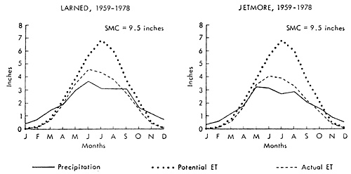
Information on many aspects of the water relations at any place can be obtained from those diagrams (Mather, 1974). The difference between the potential and actual evapotranspiration provides a measure of the moisture deficit of a place (i.e., the amount by which the available moisture fails to satisfy the demand for water). Knowledge of the moisture deficit is basic to any understanding of the economic feasibility of irrigation, for it provides information on the total volume of water needed at any time and gives a definitive measure of drought. Information on the water surplus, the amount by which precipitation exceeds the water needs when the soil is at field capacity, is fundamental in hydrologic studies that deal with the recharge of groundwater or with the runoff of water in streams and rivers. By definition, the water surplus is the water that does not remain in the surface soil layers but is available for deep percolation to the water table and overland or subsurface flow to the water courses. Thus, information on water surplus, climatically determined from the water budget, provides a knowledge of streamflow that can otherwise only be obtained from extensive stream-gauging installations and from data on flow to the groundwater table that requires detailed well records.
Hydrology
Streamflow and Baseflow
The runoff from the Pawnee watershed is measured at the Pawnee River near Larned (U.S. Geological Survey station #07141200). The location of the station is shown in Figure 3. The gross drainage area of the Pawnee Watershed is approximately 2,735 square miles. The effective drainage area appears to be 2,590 square miles or less. Numerous small undrained depressions and the lack of integrated drainage, especially in the western part of the watershed, make an accurate calculation of the effective drainage area difficult. Surface runoff in the non-contributing portion of the basin takes the form of overland flow into local depression systems.
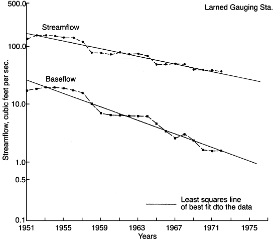
The streamflow records for the Larned station have been analyzed for 1945-1978. The average streamflow over this period is 85.95 cubic feet per second (cfs), (62,225 acre-feet per year (aft/yr)). Figure 15 shows the total annual streamflow and baseflow (the groundwater contribution to streamflow) data for that period of record, together with the mean precipitation over the area. Baseflow data were obtained from streamflow data following the separation procedures outlined by Busby and Armentrout (1965}. In order to distinguish more clearly the data trend, a seven-year and a 13-year moving average time-trend analyses are applied to these data, as shown in Figures 16 and 17, respectively. A comparison of these figures to Figure 15 indicates how the major or long-term features of the record are emphasized at the expense of shorter variations. A computer program to perform m-term smoothing is applied to these data (Davis, 1973). Smoothing reduces the variance of the original sequence; the longer the interval m, the greater the reduction. The percentage figures next to the smoothed curve (Figures 16 and 17) denotes the goodness of fit, which is a measure of the effectiveness of the smoothing process. A continuous streamflow decline is evident from these data, although average areal precipitation over the same period of record does not decrease (Figs. 15, 16). This fact indicates that a growing increase in groundwater use is probably one major cause of this streamflow decline.
Figure 15--Annual streamflow, baseflow, and precipitation for the Pawnee River Valley.
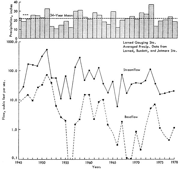
Figure 16--Seven-year moving average of annual streamflow, baseflow, and precipitation for the Pawnee River Valley.
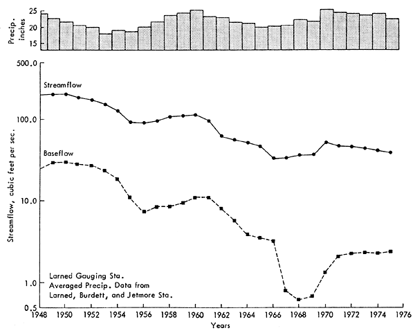
In order to estimate the average yearly declines in streamflow and baseflow, a linear regression on the log-transformed data was performed with the resulting straight lines on the semi-log paper plotted in Figure 17. Projection to the future is possible by merely extending the straight line into the future years. Correlation coefficients of 93.98 percent for the streamflow and 95.16 percent for baseflow are calculated, indicating that the straight line on the semi-log plot adequately approximates the flow data. From that figure, it can be seen that during the 1950's, the long-term average streamflow was approximately 129 cfs and baseflow approximately 17 cfs; during the 1960's, the average streamflow was approximately 64 cfs and baseflow approximately 5 cfs; while during the 1970's, they were approximately 30 and 1.3 cfs.
Figure 17--13-Year moving average of annual streamflow and baseflow for the Pawnee River Valley, Larned.
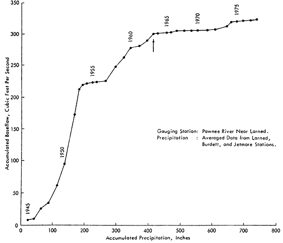
Thus, a steeper decline in baseflow is observed during the same period of record, providing further evidence of heavy groundwater withdrawals. In order to examine this observation further, a double mass analysis of cumulative baseflow versus cumulative precipitation for the study period was performed (Fig. 18). Effects of the drought in the early 1950's are evident and an apparent change in baseflow regiment occurs in the mid-60's. Average baseflow for 1945 through 1963 was 15.8 cfs (11,431 aft/yr), while the average for 1963 through 1978 was 1.5 cfs (1,093 aft/yr), which indicates a drastic reduction in baseflow after the mid-60's. This break in slope of the mass curve (Fig. 18) after 1963 coincides with a significant increase in the development of groundwater for irrigation, as can be seen from the increase in irrigated acreage (Figs. 4, 5) and the increase in well registrations (Figs. 6, 7). Reduced precipitation is not a cause of depletion of the flow in the stream since 1963 (Fig. 15). The only remaining reasonable causes of the depletions are capture by irrigation wells of water normally discharged to streams and changes in land-use practices. Among others, the latter include larger tractors and machinery to cultivate the soil, construction of terraces on land, contour farming, higher crop yields from summer following (which result in greater soil moisture depletion and consequent decrease of runoff to streams) and construction of small dams. However, quantitative evaluation of such practices is not feasible at the present time.
Figure 18--Accumulated baseflow versus accumulated precipitation for the Pawnee River.
Prev Page--Introduction, Study Area, Topography || Next Page--Hydrogeology, Hydrogeochemistry