
![]()
Prev Page--Contents || Next Page--Hydrometeorology, Hydrology
Introduction
Use of groundwater increased rapidly in Pawnee Valley during the past several years, causing water levels to decline and streamflows to diminish. For this reason, the Kansas Geological Survey was asked to undertake a short-term investigation of the alluvial aquifer in the Pawnee Valley and to evaluate the impact of present and future groundwater withdrawals in the region.
Two groundwater management districts have jurisdiction over the Pawnee Valley. The Pawnee County portion of the Pawnee Valley is under the jurisdiction of Groundwater Management District No. 5, while the Hodgeman County portion is under the jurisdiction of Groundwater Management District No. 3. Because of the severity of groundwater declines in the Pawnee Valley, the Chief Engineer of the Water Resources Division, Kansas State Board of Agriculture declared, in 1978, a moratorium on new drilling in the Pawnee County portion of Pawnee Valley pending public hearings on the matter.
This report describes the hydrogeologic system of the surficial materials along the Pawnee Valley; changes to that system caused by agricultural development over the period from 1945-47 to the present; the development of a preliminary water balance for the region; and the adaptation and use of mathematical models to assess the effects of present and future development of irrigation wells.
Data for this study were obtained from a variety of published reports and unpublished material on file at the Kansas Geological Survey or provided by the groundwater management districts involved. Because of time and financial constraints, use is made of readily available data only; no extensive field or laboratory investigations were conducted for this study. However, extensive water-level surveys of Pawnee Valley were conducted for this study during June 1979 and January 1980.
This study will be presented in two parts. The first part will deal with the hydrogeologic system and historic changes in it; the second part will deal with numerical simulation of that system, which will encompass automated parameter adjustment routines, predictive runs, and management models.
Objectives
The main objectives of this study include:
- Determination of the occurrence and availability of groundwater in the area;
- Calculation of a preliminary hydrologic budget for the area with emphasis on the groundwater component of the budget;
- Adaptation, calibration, and application of mathematical models that adequately simulate the operation of the hydrogeologic system for the purpose of evaluating the effects of present and future development on the groundwater supply under various management schemes.
Location and Extent of the Study Area
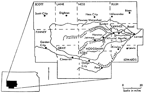
The area studied in this report, in general terms, consists of the combined Pawnee River and Buckner Creek Watersheds, referred to as the Pawnee Watershed, approximately 2,735 square miles (Fig. 1). Particular emphasis is put on the area comprising the alluvial aquifer of the Pawnee Valley, which is located in Pawnee, Hodgeman, and Ness counties. It includes the Pawnee River Valley and the main tributaries of the Pawnee River, Buckner Creek, and Sawlog Creek.
Figure 1--Area and location map.
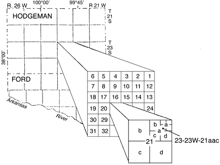
Well-numbering System
The well numbers in this report give locations according to the Bureau of Land Management's system of land subdivision. The first number indicates the township; the second number indicates the range west of the sixth principal meridian; and the third number indicates the section, followed by letters that indicate the subdivision of the section in which the well is located. The first letter denotes the quarter section or 160-acre tract; the second letter, the quarter-quarter section or 40-acre tract; and the third letter, when used, the quarter-quarter-quarter section or 10-acre tract. The 160-acre, 40-acre, and 10-acre tracts are designated a, b, c, and d, in a counterclockwise direction beginning in the northeastern quadrant. As an example, well 23-23W-21 aac is in the SW NE NE sec. 21, T.23 S., R.23 W. (Fig. 2).
Figure 2--Well numbering system.
Topography, Drainage, and Land Use
The study area lies in the High Plains subsection of the Great Plains physiographic province. The principal topographic features of the area are flat bottomlands and terraces. Altitudes range from approximately 2,900 feet near the westernmost edge of the watershed to approximately 2,000 feet near the easternmost end of the watershed near Larned (Fig. 3).
Figure 3--Topography and drainage of the Pawnee Watershed
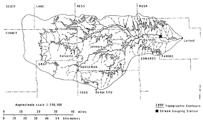
The watershed area is drained by the Pawnee River and its many tributaries. The Pawnee River originates in Finney County and joins the Arkansas River at Larned in Pawnee County. Its largest tributary, Buckner Creek, originates in the northeastern part of Gray County and joins the Pawnee River near the northeast corner of Hodgeman County. The largest tributary of Buckner Creek is Sawlog Creek, which originates in the northwest corner of Ford County and joins Buckner Creek at Hanston in Hodgeman County (Fig. 3). The drainage pattern of the Pawnee Valley Watershed is dendritic (characterized by irregular branching of tributary streams in many directions). Such a pattern usually develops in areas where structural control, such as faults and folds, is missing and where the underlying rock units are nearly horizontal; both of these characteristics are prevalent in the study area.
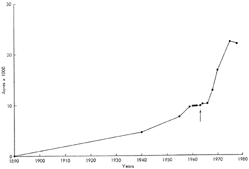
The land is used for agricultural purposes under both dryland and irrigation conditions. The major crops in the area are wheat, sorghum, alfalfa hay, and corn. The increase in irrigated acreage is shown in Figures 4 and 5 for the entire Pawnee and Hodgeman counties, where a dramatic increase since the mid-60's is clearly evident. During the forties, irrigated acreage represented approximately 1.3 percent of the total acreage in Pawnee County and 0.8 percent of Hodgeman County. In 1978, the irrigated acreage comprised approximately 13.4 percent of the total acreage in Pawnee County, a tenfold increase, and 4.0 percent of Hodgeman County, a fivefold increase.
Figure 4--Irrigated acreage, Pawnee County. Souce of Data: Division of Extension, Extension Agricultural Engineering, Kansas Stale University
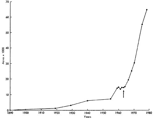
Figure 5--Irrigated acreage, Hodgeman County
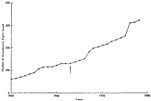
The major source of irrigation water in Pawnee Valley is groundwater; therefore, the increase in irrigated acreage has had a significant effect on that source. The historic growth of well registration in the entire Pawnee and Hodgeman counties is shown in Figures 6 and 7. In Pawnee County, growth is exponential, closely matching that of the irrigated acreage growth. A similar growth, but of a smaller scale, is also observed in Hodgeman County.
Figure 6--Number of groundwater rights issued in Pawnee County from 1950 to 1978. Source of Data: Division of Water Resources, Stafford Field Office.
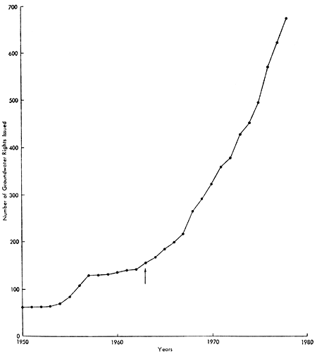
Figure 7--Number of groundwater rights issued in Hodgeman County from 1950 to 1978. Source of Data: Division of Water Resources, Stafford Field Office.
Geology and Soils
The geology of the area, as related to groundwater, is described by McLaughlin (1948) and Fishel (1952), and is summarized as follows.
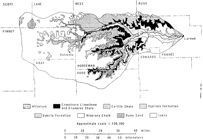
The rocks that crop out in the Pawnee Valley are sedimentary and range in age from Cretaceous to Quaternary (Fig. 8). The oldest rocks exposed are Cretaceous and comprise the Dakota Formation, Graneros Shale, Greenhorn Limestone, and Carlile Shale. The Ogallala Formation of Tertiary age caps the upland area in much of Hodgeman County. The terrace deposits that cover large areas adjacent to the Pawnee River are believed to be Pleistocene in age, but may be Tertiary in part. The alluvium in the principal valleys is Pleistocene. Most upland surfaces are thinly mantled with eolian silt or loess.
Figure 8--Geologic formations of the Pawnee Watershed.
A generalized stratigraphic section of the geologic formations of the study area, together with their physical and water-supply characteristics, is given in Table 1.
The consolidated rocks that underlie the unconsolidated Tertiary and Quaternary deposits are referred to as bedrock. These rocks are not considered to be major aquifers in the area but do supply water for some irrigation wells in the upland areas of the valley (Table 1). The principal water-bearing materials underlying the study area are the unconsolidated deposits of Quaternary age. The Tertiary age Ogallala Formation, although the principal aquifer in western Kansas, yields relatively small quantities of water in the Pawnee Valley Watershed because it is the eastern fringe of the Ogallala Formation and is highly dissected, thinned, and largely drained of water. The Quaternary system in the Pawnee Watershed consists of terrace deposits and alluvium (Table 1), which form the alluvial aquifer. The terrace deposits overlie the Cretaceous rocks on both sides of the Pawnee River throughout most of Pawnee County and extend into Ness and Hodgeman counties.
Table 1--Generalized section of the geologic formations in Pawnee Valley, Kansas. Modified from Fishel, 1952. NOTE: In this report, small quantities refers to yields generally less than 10 gallons per minute (gpm), moderate quantities to 10 to 500 gpm, and large quantities to greater than 500 gpm.
| System | Series | Subdivision | Thickness (feet) |
Physical character | Water supply |
|---|---|---|---|---|---|
| Quaternary | Pleistocene | Loess | 0-10 | Silt, windblown, locally reworked and deposited by streams. | Most of deposits above water-table. Not known to yield water to wells. |
| Alluvium | 0-135 | Coarse sand and gravel containing silt and clay. Sand and gravel generally overlain by 15 to 50 feet of silt and clay. | Yields large quantities of water to domestic, stock, and irrigation wells. | ||
| Terrace deposits | 0-150 | Principally silt and clay but locally contains considerable sand and gravel. | Yields moderate supplies of water to domestic and stock wells and to a few irrigation wells. | ||
| Tertiary | Pliocene | Ogallala Formation | 0-100 | Consists mainly of silt, sand, and gravel containing caliche. | Yields fair amounts of water for stock and domestic wells in parts of Ness and Hodgeman Counties. |
| Cretaceous | Upper | Carlile Shale | 0-100 | Chalky shale containing thin beds of chalky limestone. | Yields small quantities of water to wells in adjacent area but not known to yield water to wells in this area. |
| Greenhorn Limestone | 0-125 | Chalky shale containing thin beds of crystalline limestone at base and granular to chalky limestone in upper part. | Yields small quantities of water to dug wells in northern Pawnee County. | ||
| Graneros Shale | 20-36 | Dark-gray shale containing sandy shale and lenses of sandstone. | Yields no water to wells in this area. | ||
| Lower | Dakota Formation | 20-300 | Consists principally of buff, yellow-brown and brown sandstone and vari-colored clay and sandy clay. | Yields small to moderate quantities of water to domestic and stock wells, and to a few irrigation wells. | |
| Kiowa Shale | 100-230 | Dark-gray to black shale containing lenses of sandstone. | Yields no water to wells in this area. | ||
| Cheyenne Sandstone | 15-50 | Gray, tan and white fine to medium-grained sandstone. | Yields no water to wells in this area due to its considerable depth. Water may be highly mineralized. |
Inasmuch as the terrace deposits consist primarily of silt and clay and lesser amounts of sand and gravel, this formation yields generally moderate quantities of water to wells. However, in places where the deposits contain much sand and gravel, the beds yield adequate water for irrigation. Alluvium underlies the bottomland of the Pawnee River and some of its larger tributaries. The alluvium of the Pawnee Valley is as wide as three miles in parts of the Pawnee Valley and two miles in Hodgeman and Ness counties. The base of the alluvium is shown by the bedrock contour map (Fig. 9). The alluvium of Pawnee, Buckner, and Sawlog Valleys yields large quantities of water to wells.
Figure 9--Base map of Pawnee Valley, Kansas, alluvial aquifer.
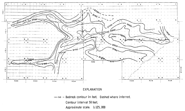
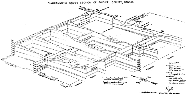
Figure 10 is a fence diagram showing the distribution of the various rock units in Pawnee County.
Figure 10--Diagrammatic cross section of Pawnee County, Kansas. [Modified from Plate 3, T.G. McLaughlin, 1949, KGS Bulletin 80.]
The soils of the Pawnee Watershed were formed mainly from deposits of loess, outwash material, and alluvium. In areas where these deposits are absent, the soils generally formed in material weathered from semi-consolidated caliche or chalky shale interbedded with thin layers of limestone. Figure 11 is a generalized soils association map of the Pawnee Watershed. Construction of this map involved some grouping of various soil associations presented in the general county soil maps (Dodge and others, 1965, 1978; Harner and others, 1965, Sallee and Hamilton, 1965; Tomasu and Roth, 1968; Sallee, 1972; Haberman and others, 1973; Roth, 1973; Rott and Haberman, 1977) and some regrouping of soil associations used in those reports in order to reflect better the pattern of soils in the natural landscapes for the multicounty area. Table 2 is a brief description of the soil association groups used in this map. Table 3 indicates the major soil series, their texture, and their water-holding properties.
Figure 11--General Soils Map for the Pawnee Watershed.
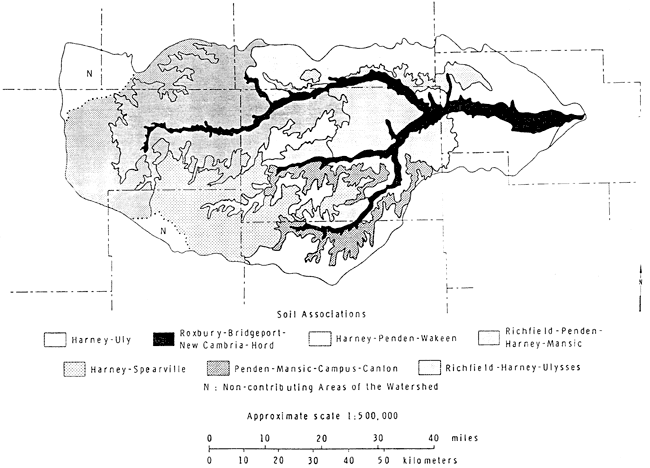
Table 2--Soil Associations of the Pawnee Watershed
|
Table 3--Characteristics of the major soil series in the Pawnee Watershed
| Soil Series | Surface Layer | Subsoil | Underlying Material (up to 4 feet) |
SMC | WP | |||
|---|---|---|---|---|---|---|---|---|
| 1 (in) |
2 | 1 (in) |
2 | 1 (in) |
2 | 3 (in/4') |
4 (in/4') |
|
| Harney | 12 | SiL | 23 | SiCL | 13 | SiL | 9.86 | 9.10 |
| Uly | 10 | SiL | 8 | SiL | 30 | SiL | 10.32 | 8.64 |
| New Cambria | 14 | SiCL | 21 | SiC | 13 | SiCL | 8.10 | 10.77 |
| Bridgeport | ll | SiL | 7 | SiL | 30 | SiL | 10.30 | 8.68 |
| Hord | 12 | SiL | 30 | SiCL | 6 | SiL | 9.72 | 9.24 |
| Roxbury | 22 | SiL | 20 | SiCL | 6 | CL | 9.56 | 9.34 |
| Penden | 16 | SiCL | 12 | CL | 20 | CL | 8.08 | 10.68 |
| Richfield | 7 | SiL | 14 | SiCL | 27 | SiCL | 9.50 | 8.70 |
| Wakeen | 10 | SiL | 10 | SiCL | 16 | CL | 6.64 | 7.38 |
| Campus | 8 | L | 8 | CL | 14 | L | 5.94 | 4.44 |
| Canlon | 6 | L | 7 | L | Caliche | 2.71 | 1.72 | |
| Spearville | 7 | SICL | 18 | SiC-SiCL | 23 | SiL | 9.11 | 9.81 |
| Ulysses | 6 | SiL | 9 | SiL-SiCL | 33 | SiL | 10.23 | 8.76 |
| Mansic | 9 | CL | 26 | CL | 13 | CL | 7.38 | 11.34 |
| 1. Thickness of layer 2. Textural classification 3. Soil moisture capacity (SMC) 4. Wilting point (WP) Abbreviations: SiL = Silty loam SiCL = Silty clay loam L = Loam CL Clay loam |
||||||||
The formation of these soils is the result of the action of soil-forming proceses on material deposited or altered by geologic forces (Haberman and others, 1973). After the Rocky Mountains were uplifted, the Ogallala Formation, of middle Pliocene age, was deposited by streams that carried debris from these mountains. These deposits mantled the bedrock of the Pawnee Watershed. Much of this material was removed by subsequent erosion during the early Pleistocene. Later, sedimentation was resumed, and the valleys cut in the Ogallala and the areas where the formation was eroded away were filled with fine-grained sediments. These deposits consist primarily of silt and clay, but contain lesser amounts of sand and gravel. These deposits formed the Meade Formation and terrace deposits. Penden soils formed in the outwash.
Late in the Pleistocene age, the valleys of the Pawnee River and of Buckner and Sawlog Creeks were eroded and cut somewhat below their present depth. This was followed by the deposition of stream-laid silt, sand, and gravel that formed the alluvium in the valleys. Probably, during this time and into Recent time, there was a climatic change and the wind velocity became very strong. A layer of windblown silt, Peorian loess, was deposited over most of the Watershed. The principal soils formed in loess are Harney, Richfield, Spearville, and Uly.
The alluvium deposited in Recent time is the youngest parent material of the watershed soils. Roxbury soil formed in this material. Much of the present topography is the result of erosion and deposition that started during the latter part of the Pleistocene age and has continued until the present.