![]()
Prev Page--Ground Water || Next Page--Well Records
Water-bearing Formations
Cretaceous System
Pierre Shale
Rocks of Cretaceous age do not crop out in Thomas County. However, the Pierre shale of Cretaceous age crops out along valleys immediately adjacent to the county on the southwest, along Beaver Creek valley in Rawlins County to the north, and in large areas of central Wallace and Logan counties. The Pierre shale underlies all of Thomas County at relatively shallow depths and serves as an impervious floor below the water-bearing sediments. It retards the downward percolation of water in much the same manner as the floor of a tank. Although the thickness of the Pierre shale below all parts of the county is not known, it is probably nowhere less than 100 feet thick and may be as much as 1,000 feet thick under the northwestern part of the county. Contours that show the topography of the Pierre shale surface have been plotted from test-hole data and are shown in figure 13.
Figure 13--Contour map showing the topography of the Pierre shale surface. Figures denote altitude of the Pierre shale surface in test holes, and figures in parentheses are the test-hole numbers which correspond to the numbers of the logs included in this report.
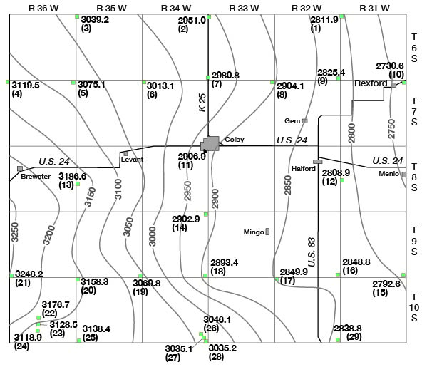
The Pierre shale of northwestern Kansas has been studied in detail by Elias (1931). It consists of gray, blue-gray, and black clayey shale containing zones of abundant concretions and thin beds of bentonite. Elias divided the Pierre shale into five named members and one unnamed unit. These are, in ascending order: Sharon Springs shale, Weskan shale, Lake Creek shale, Salt Grass shale, an unnamed shale interval, and the Beecher Island shale at the top. Probably all but the uppermost of the named members are present under Thomas County. The Pierre shale does not yield water to wells in Thomas County.
Tertiary System
Ogallala Formation
The Ogallala formation was named by Darton in 1899 (pp. 734, 735, 741, 742, pl. 84) from a locality in southwestern Nebraska. In 1920 Darton (p. 6) referred to the type locality as near Ogallala station in western Nebraska. Elias (1931) has made detailed studies of the Ogallala formation in Wallace County, Kansas, adjacent to Thomas County on the southwest. In 1937 he (Elias, 1937) briefly described the Ogallala deposits in Rawlins and Decatur counties to the north, and in 1942 (Elias, 1942) described the Tertiary fossil seeds and other plant remains of the central High Plains. Smith (1940) has discussed the character and origin of the Ogallala, especially in southwestern Kansas, and these deposits have recently been described in detail in several southwestern Kansas counties (Frye, 1942; Latta, 1941, 1944; McLaughlin, 1942, 1948; Waite, 1942).
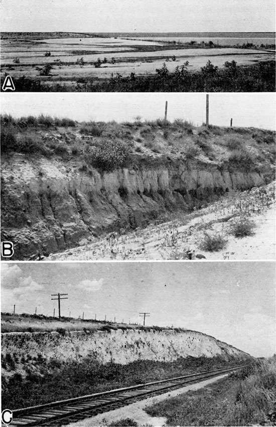
Plate 6--A, Undrained upland depression, north side of South Sappa creek due north of Levant. B, Exposure of Ogallala formation along road cut south of Prairie Dog creek due north of Rexford. C, Silt of the Sanborn formation in railroad cut (Chicago, Rock Island and Pacific) west of Levant.
Character--The Ogallala formation consists of clay, silt, sandy silt, cross-bedded sand and gravel (pl. 6B), and locally sandy limestone. In areas adjacent to Thomas County it also contains beds of volcanic ash, diatomaceous marl, bentonitic clay, and hard silicified beds that resemble chert or quartzite. The generalized character of the Ogallala is given by the logs of test holes included in this report. As there are no exposures that permit a continuous examination of any considerable thickness of these strata in Thomas County, the beds were examined along canyon walls in southern Rawlins County and also in northeastern Wallace County. The following stratigraphic section was measured 1.4 miles north of the Thomas County line in eastern Rawlins County.
| Measured section of the Ogallala formation, SE sec. 30, T. 5 S., R. 32 W., Rawlins County. (Measured by John C. Frye and August Lauterbach.) | ||
|---|---|---|
| Bed No. |
Description | Thickness (feet) |
| 13. | Mostly covered, capped by nodular mortar bed, irregular, hard, gray, | 6.0 |
| 12. | Mortar bed, coarse gravel to sand cemented by calcium carbonate; weathers irregularly cavernous | 5.5 |
| 11. | Silt, sand, and gravel; massive; poorly sorted; red-tan | 7.0 |
| 10. | Mortar bed, sand and some fine gravel; loosely cemented by calcium carbonate; friable; gray | 1.5 |
| 9. | Silt, sand, and gravel; massive; poorly sorted; red-tan | 17.8 |
| 8. | Mortarbed, hard, massive, gray | 4.0 |
| 7. | Sand, fine, and silt; tan to red-buff, partly covered | 7.5 |
| 6. | Mortarbed, hard, gray | 3.5 |
| 5. | Sand, fine to medium, tan to buff, partly covered | 6.0 |
| 4. | Mortarbed, sand and coarse gravel; hard; gray | 2.2 |
| 3. | Sand and gravel; tan | 9.5 |
| 2. | Caliche and mortar bed; massive; having thin lenses of clay and silt interbedded; light gray to light gray-tan | 8.0 |
| 1. | Silt and fine sand; massive; gray; covered in lower part | 13.7 |
| Total thickness of beds measured | 92.2 | |
A section of the Ogallala formation was measured along a creek bank and road cut in northwestern Thomas County. The total thickness is much less than that in the measured section in Rawlins County but the general character of the beds is about the same.
| Measured section in the SW corner sec. 26, T. 6 S., R. 31 W., Thomas County. (Measured by John C. Frye.) | ||
|---|---|---|
| Bed No. |
Description | Thickness (feet) |
| Sanborn formation | ||
| 10. | Silt and fine sand; gray; containing concretions of calcium carbonate | 20.0 |
| Ogallala formation | ||
| 9. | Sand, silt and caliche; buff | 10.0 |
| 8. | Mortarbed of sand and gravel; gray | 0.4 |
| 7. | Clay and silt; blocky; gray with yellow along some bedding planes; containing some carbonaceous material | 0.6 |
| 6. | Sand and silt containing some soft caliche; light gray | 1.8 |
| 5. | Silt and sand; tan; containing a few pebbles and caliche | 5.2 |
| 4. | Sand and some gravel; cemented; gray | 0.5 |
| 3. | Silt, sand, and gravel; containing some stringers of caliche; red-tan and gray | 12.4 |
| 2. | Mortar bed of sand, gray | 1.5 |
| 1. | Silt and sand; red-tan and gray; containing some caliche | 4.8 |
| Total thickness of beds measured | 57.8 | |
In order to determine the grain size and sorting, the percentage of soluble material, and the permeability of the several beds, samples were collected from seven of the beds described in the stratigraphic section measured in Rawlins County. Analyses of these samples were made by Ada Swineford and Carrie Thurber and are reported in table 6. The solubility was determined by digesting a known quantity of sample in dilute hydrochloric acid, the spent acid and dissolved material were then washed from the sample and the residue was caught on filter paper, dried, and weighed. A mechanical analysis, or sieve analysis, was made of the insoluble fraction of each sample by placing a known weight of dry sample in a set of sieves and agitating the sieves for 20 minutes in a mechanical shaker. The fraction caught on each sieve was then weighed and the percentage calculated. The analyses of loess and slope deposits reported in tables 7 and 8 were made by the same method supplemented by pipette determinations of grade sizes less than 0.062 mm.
Table 6--Physical properties of samples of the Ogallala formation from the measured section in sec. 30, T. 5 S., R. 32 W., Rawlins County. By Ada Swineford and Carrie B. Thurber.
| No. of bed in measured section | Mechanical analysis (percent by weight) | Coefficient of permeability* | Percent soluble in dilute HCl | |||||||
|---|---|---|---|---|---|---|---|---|---|---|
| Coarse gravel (larger than 4.0 mm) | Medium gravel (4.0-2.0 mm) | Fine gravel (2.0-1.0 mm) | Coarse sand (1.0-0.5 mm) | Medium sand (0.5-0.25 mm) | Fine sand (0.5-0.25 mm) | Very fine sand (0.125-0.062) | Silt and clay (less than 0.062 mm) | |||
| 9 | 2.0 | 5.6 | 9.2 | 11.7 | 17.2 | 16.4 | 16.0 | 21.9 | 107 | 9.3 |
| 7 | 0.1 | 0.5 | 3.6 | 25.1 | 36.9 | 18.2 | 15.6 | 154 | 9.4 | |
| 5 | 0.2 | 2.0 | 4.3 | 11.1 | 24.1 | 31.8 | 18.4 | 8.0 | 172 | 4.2 |
| 4 | 0.6 | 4.5 | 9.5 | 16.1 | 28.1 | 27.0 | 10.8 | 3.3 | 38.1 | |
| 3 | 5.4 | 4.3 | 12.1 | 27.2 | 33.1 | 15.2 | 2.2 | 0.4 | 609 | 1.9 |
| 2 | tr. | 1.6 | 11.4 | 30.5 | 36.5 | 11.4 | 8.4 | 23.4 | ||
| 1 | 0.1 | 5.5 | 20.3 | 26.8 | 19.2 | 28.1 | 107 | 3.0 | ||
| * Gallons of water a day, at 60 deg. F., that is conducted laterally through each mile of water-bearing bed under investigation (measured at right angles to the direction of the flow), for each foot of thickness of the bed and for each foot per mile of of hydraulic gradient. | ||||||||||
Table 7--Mechanical analyses of samples of loess collected at vertical intervals of 5 feet from Rock Island Railroad cut, SW NW sec. 8, T. 8 S., R. 35 W. By Ada Swineford and Carrie B. Thurber.
| Sample no. | Mechanical analysis (percent by weight) | ||||||||||
|---|---|---|---|---|---|---|---|---|---|---|---|
| 1.0-0.5 mm | 0.5-0.25 mm | 0.25-0.125 mm | 0.125-0.062 mm | 0.062-0.031 mm | 0.031-0.0156 mm | 0.0156-0.0078 mm | 0.0078-0.0039 mm | 0.0039-0.00195 mm | 0.00195-0.00098 mm | Less than 0.00098 mm | |
| 7 | 0.8 | 2.9 | 3.4 | 9.3 | 52.3 | 17.1 | 4.8 | 3.8 | 1.4 | 1.1 | 2.9 |
| 6 | 0.1 | 0.8 | 2.1 | 6.0 | 61.9 | 15.1 | 5.5 | 4.0 | 1.4 | 1.0 | 2.1 |
| 5 | 0.1 | 0.4 | 7.0 | 4.1 | 46.3 | 30.6 | 6.8 | 4.7 | 1.8 | 1.2 | 3.3 |
| 4 | 0.2 | 1.1 | 1.7 | 7.4 | 64.3 | 15.3 | 4.1 | 2.3 | 1.0 | 0.6 | 2.0 |
| 3 | 0.2 | 0.4 | 6.1 | 57.6 | 22.1 | 5.7 | 3.7 | 1.1 | 1.0 | 2.1 | |
| 2 | 0.5 | 0.9 | 5.1 | 54.7 | 23.5 | 6.1 | 4.2 | 1.2 | 1.0 | 2.8 | |
| 1 | 0.3 | 5.0 | 64.2 | 18.5 | 4.2 | 3.1 | 1.2 | 1.0 | 2.4 | ||
Table 8--Mechanical analyses of samples of slope deposits from roadside cut along south side of South Sappa Creek valley, W. center sec. 25, T. 7 S., R. 35 W. By Ada Swineford and Carrie B. Thurber.
| Sample No. | Mechanical analysis (percent by weight) | |||||||||||||
|---|---|---|---|---|---|---|---|---|---|---|---|---|---|---|
| Larger than 4 mm | 4-2 mm | 2-1 mm | 1.0-0.5 mm | 0.5-0.25 mm | 0.25-0.125 mm | 0.125-0.062 mm | 0.062-0.031 mm | 0.031-0.0156 mm | 0.0156-0.0078 mm | 0.0078-0.0039 mm | 0.0039-0.00195 mm | 0.00195-0.00098 mm | Less than 0.00098 mm | |
| 11 | 0.1 | 0.4 | 0.8 | 4.8 | 49.8 | 22.8 | 8.6 | 4.3 | 3.0 | 2.0 | 3.5 | |||
| 10 | 0.3 | 1.2 | 0.9 | 4.9 | 53.2 | 20.5 | 7.9 | 4.2 | 2.1 | 1.7 | 3.1 | |||
| 9 | 0.4 | 1.2 | 1.1 | 5.0 | 50.2 | 20.6 | 8.0 | 3.6 | 2.3 | 1.5 | 6.1 | |||
| 8 | 2.1 | 6.3 | 2.4 | 4.8 | 44.1 | 20.7 | 7.1 | 3.4 | 2.0 | 1.3 | 5.8 | |||
| 7 | 2.0 | 6.2 | 3.1 | 4.4 | 43.9 | 19.9 | 7.4 | 3.8 | 2.0 | 1.6 | 5.6 | |||
| 6 | 2.8 | 13.1 | 4.8 | 4.7 | 39.6 | 17.4 | 5.7 | 2.9 | 2.0 | 1.3 | 5.6 | |||
| 5 | 0.1 | 0.7 | 0.8 | 6.2 | 49.2 | 22.6 | 8.3 | 3.7 | 1.8 | 1.4 | 5.1 | |||
| 4 | 0.4 | 1.9 | 1.7 | 5.2 | 49.2 | 22.9 | 7.5 | 3.3 | 1.6 | 1.2 | 5.0 | |||
| 3 | 0.8 | 6.6 | 12.3 | 16.8 | 19.3 | 9.6 | 7.0 | 16.5 | 3.4 | 1.5 | 1.1 | 0.7 | 0.4 | 3.9 |
| 2 | 0.3 | 2.2 | 4.2 | 12.3 | 9.8 | 50.9 | 8.2 | 2.2 | 2.8 | 1.5 | 1.0 | 4.5 | ||
| 1 | 1.0 | 4.3 | 3.1 | 8.3 | 49.3 | 16.6 | 4.3 | 4.3 | 1.9 | 1.6 | 5.2 | |||
A comparison of the analyses in table 6 with the descriptions of the beds given in the measured section in Rawlins County indicates that the caliche and mortar beds have a high percentage of calcium carbonate, which represents the soluble fraction. In these two beds (2 and 4) the percentage of soluble material was 23 and 38. The insoluble fraction of the mortar beds corresponds closely to the sand and gravel beds that contain a smaller amount of soluble material. It will be noted that none of the samples is very well sorted. The highest percentage of material in any one grade is 36.91 in the fine-sand fraction of the sample from bed 7. The Ogallala formation consists essentially of partly discontinuous and interconnected lenticular bodies of stream-deposited sand and gravel interspersed through an enclosing mass of poorly sorted stream-deposited clay, silt, sand, and gravel. Locally where the top of the formation has not been eroded away, there is a capping layer of sandy ("Algal") limestone. The logs and measured sections give the general character of the formation but because of its manner of deposition the details of lithology range widely in short horizontal distances in some places, whereas they may be quite persistent in other places.
Distribution and thickness--The Ogallala formation underlies all of Thomas County and rests directly upon the Pierre shale. As shown in plate 1, it is overlain in most parts of the county by the Sanborn formation, slope deposits, or alluvium. The thickness of the Ogallala under Thomas County is shown by the 29 logs of test holes to range from 77 feet in test hole 7 to 266 feet in test hole 14. The average thickness in the 29 test holes is 165 feet. In general the Ogallala is thick under northwestern, central, and eastern Thomas County and thin under the southwestern and north-central parts.
Age and correlation--The beds in the type area of the Ogallala formation near Ogallala, Nebraska, have been studied by Elias (1931) and the fossil vertebrates have been described and discussed (Hibbard, 1983; Hesse, 1935; Stirton, 1985, p. 444). A committee report on the nomenclature and correlation of the North American continental Tertiary (Wood, et al., 1941, pl. 1, pp. 12, 27) placed the Ogallala of Kansas and eastern Colorado in the Blancan, Hemphillian and Clarendonian, and the Ogallala of Nebraska and eastern Wyoming in the lowermost Blancan, the Hemphillian, Clarendonian, and upper part of the Barstovian, North American provincial age zones, which they correlated with the upper, middle, and lower Pliocene and upper Miocene, respectively. They listed the characteristic fossil vertebrates for each of these provincial age zones. Lugn (1939) presented a classification of the Tertiary formations of Nebraska in which he considered the Ogallala as a group containing the following formations in ascending order: Valentine, Ash Hollow, Sidney gravel, and Kimball, all of Pliocene age (p. 1266). Elias (1931, pp. 149-153; 1932; 1942) described plant remains from the Ogallala of the High Plains region and correlated certain zones over wide areas. The Ogallala is generally agreed to be of Pliocene age.
During the progress of field work in Thomas County, I collected from the Ogallala formation (middle North line sec. 18, T. 8 S., R. 36 W.) one fossil tooth (Kansas University Museum of Vertebrate Paleontology no. 6550) that has been identified by C. W. Hibbard of the University of Kansas as ?Pliohippus. Allan Graffham collected fossil vertebrates from a gravel pit south of Brewster (sec. 29, T. 8 S., R. 36 W.). One fossil from the Ogallala in the lower part of the pit has been identified by C. W. Hibbard as Pliohippus cf. ansae (Matthew and Stirton).
For the purpose of this paper the Ogallala is classed as a formation rather than as a group as used by Lugn, and definite correlation is not made with the stratigraphic units widely used in Nebraska. A sample of limestone from an outcrop just northwest of Brewster was submitted to M.K. Elias of the Nebraska Geological Survey, who identified it as a typical specimen of the "Chlorellopsis limestone" (personal communication dated September 22, 1944). The presence of this bed, which marks the top of the Ogallala of Nebraska, indicates that the Thomas County section includes stratigraphic equivalents of the upper part of the Ogallala of Nebraska. Although the limits of the several stratigraphic units have not been drawn in this area, age equivalents of Lugn's Kimball, Sidney gravel (?), and Ash Hollow are probably included within the Ogallala, but it is my opinion that most of the Ogallala in this area is of Ash Hollow age. The lower part of the Ogallala formation is not exposed in Thomas County and it may include beds equivalent in age to the Valentine or even older beds in Nebraska.
A clay zone having the appearance of a bentonitic clay is present in some of the test holes between the base of the Ogallala and the top of the Pierre shale. This clay is tan to light gray and seems to grade downward into typical blue-gray or black Pierre shale, thus probably representing the product of weathering of the Pierre prior to the deposition of the Ogallala. It is possible, however, that in some places this may represent the Woodhouse clay described by Elias (1931, pp. 155-158) as occurring at the base of the Ogallala in Wallace County.
Water supply--The sand and gravel of the Ogallala formation is the primary source of ground water in Thomas County. Nearly all the wells in the county obtain all or part of their water from this formation. The finer materials of the formation generally are porous and hold considerable water but are not permeable enough to yield water freely. The coarser materials, the gravels in particular, commonly yield abundant supplies of water.
Mechanical analyses and coefficients of permeability of samples from a measured stratigraphic section of the Ogallala are given in table 6. The permeability of a water-bearing material is its capacity for transmitting water under pressure. The coefficient of permeability, as determined in the field or laboratory, is expressed by O.E. Meinzer as the number of gallons of water a day at 60 deg. F. that is conducted laterally through each mile of the water-bearing bed under investigation (measured at right angles to the direction of flow) for each foot of thickness of the bed, and for each foot per mile of hydraulic gradient (Stearns, 1927, p. 148). The coefficients of permeability given in table 6 were determined by means of a portable apparatus designed by V. C. Fishel of the Federal Geological Survey. It will be noted that the coefficient of permeability of five samples ranged from 107 to 609.
Concerning the relation of the permeability of water-bearing material to the yield of wells, Wenzel (1942, p. 11) stated:
"Although there are many water-bearing materials of low permeability, most formations that are sufficiently water-bearing to be utilized by wells have coefficients that are whole numbers of two or more figures when expressed in Meinzer's units--that is, above 10. The yields of wells depend, of course not only on the permeability of the formations they tap but also on the thickness of the formations, the drawdown of the water level, and the diameter and construction of the wells. For many places in the United States the physical and economic conditions are such that wells with moderate to high yields--100 gallons a minute or more--generally penetrate materials with coefficients of permeability of 100 or more."
This indicates that the permeability of the sand and gravel beds of the Ogallala formation is sufficient to permit the development of wells of large capacity--it is not as high, however, as the permeability of some of the materials yielding water to irrigation wells in southwestern Kansas. By comparison the coefficient of permeability of four samples of Dakota sandstone in Ford County (Waite, 1942, p. 48) ranged from less than 1 to 28, and the coefficients of test-hole samples of the Ogallala in Meade County (Frye, 1942, p. 92) ranged from 22 to 5,300. Coefficients of permeability determined by pumping tests on irrigation wells in Finney and Gray counties (Latta, 1944, p. 54) ranged from 235 to 1,040. Coefficients determined by the same method in Hamilton and Kearny counties (McLaughlin, 1943, p. 47) ranged from 280 to 9,113. For the most part the materials of very high permeabilities were tapped by irrigation wells drawing water from alluvium and not from the Ogallala formation.
The Ogallala formation is a large underground reservoir that is only partly filled with water. The thickness of saturated material is shown in the cross sections in figures 3 and 4. Logs and test holes indicate that a large percentage of the saturated zone of the Ogallala is composed of sand and gravel; therefore the amount of water available is large.
All but one of the analyses in table 5 are of water pumped from the Ogallala formation; thus the section on quality of water refers especially to this formation.
Quaternary System
Sanborn Formation
In 1981 Elias (pp. 168-181) described unconsolidated Pleistocene deposits, consisting mostly of silt--or loess--in northwestern Cheyenne County, Kansas, and named these deposits the Sanborn formation from the town of Sanborn, located just north of the type area in Nebraska. Beds of similar character in Nebraska have been studied and described by Lugn (1935, pp. 128-168). Elias (1937, p. 7) briefly described the occurrence of this formation in Rawlins and Decatur counties, and the stratigraphy, fossil mollusks, and fossil vertebrates have recently been studied (Leonard and Frye, 1943; Hibbard, Frye, and Leonard, 1944).
Character--In north-central Kansas, the Sanborn formation generally consists of a basal sand and gravel that ranges in texture and composition from grains and pebbles of chalk and shale to boulders of igneous rocks; this is overlain by heterogeneous deposits of clay, silt, sand, and gravel that are light gray to red-brown. A distinct soil zone is present at the top of these heterogeneous deposits and separates them from the overlying beds. The beds above the soil zone consist of massive silt--or loess--containing some zoned of fine to very fine sand (Hibbard, Frye, and Leonard, 1944). In Thomas County, which was probably a part of an upland divide area during Sanborn time, the prominent soil zone and lower beds of the Sanborn seemingly were not formed. At a few places very coarse sand and gravel containing cobbles several inches in diameter have been observed overlying the Ogallala at the base of the Sanborn formation, but for the most part the Sanborn of this area consists of massive silt containing a thin sandy zone at the base (see well logs, and cross-sections in figs. 3 and 4).
Along the Rock Island Railroad near Levant (SW NW sec. 8, T. 8 S., R. 35 W.) more than 80 feet of this massive silt, or loess, is exposed in the nearly vertical side of a cut (pl. 6C). Samples were collected from this cut at vertical intervals of 5 feet and mechanical analyses of them were made by Ada Swineford and Carrie B. Thurber. The results of these analyses are given in table 7. The uppermost sample, no. 7, was collected from the upper 8 inches of soil.
The high degree of sorting displayed by this material is indicated in table 7 by the fact that more than 50 percent by weight of six of the seven samples was included in the single fraction 0.062-0.081 mm. Russell (1944, p.3) stated concerning the definition of loess: "In the writer's experience the single fraction 0.01-0.05 mm. ordinarily constitutes at least 50 percent (by weight) of a sample and in many cases amounts to 75 percent." Although these exact units were not used in the analyses reported here, Ada Swineford (personal communication) determined graphically the percentage of each sample included in this fraction, and found that from 59 to 70 percent of the material was included in the fraction 0.01-0.05 mm. indicating a degree of sorting comparable to that required by Russell for loess. The sorting and major grades of these samples are comparable to those of other samples of loess from the High Plains and of wind blown dust reported by Swineford and Frye (1945).
The origin of loess deposits has been discussed at length by Russell (1944) who concluded that loess is generally not formed by eolian processes but is produced by a process he called loessification, operating on water deposited material. Frye (1945, p. 86) discussed the problems of the loess in northwestern Kansas and pointed out that although Russell's hypothesis of origin seems to explain adequately some of the deposits of massive silt along terraces in central and southern Kansas and some of the valley-side or slope deposits in northwestern Kansas, it cannot be accepted for the extensive loess--or silt--deposits that comprise the upper part of the Sanborn formation. The cross sections (figs. 3 and 4) show that this deposit blankets the highest part of the uplands to depths of more than 40 feet and therefore no parent material seems to be available for the loessification process. There may be a question, based on Russell's discussion, as to whether or not an eolian deposit such as this should be called "loess."
Distribution, thickness, and surface form--As shown on plate 1, the Sanborn formation and associated slope deposits underlie the surface of most of Thomas County. The logs of test holes included with this report indicate that the Sanborn formation attains a maximum thickness of more than 80 feet and commonly is 35 to 40 feet thick in the county. In the upland-divide areas the surface developed on the Sanborn formation is a flat to gently rolling plain (pl. 8B). In some places low bluffs (pl. 3C) were formed along valley sides, and along the major valleys these deposits merge with slope deposits to produce gentle well-rounded valley slopes.
Age and correlation--The Sanborn formation is separated from the underlying Pliocene Ogallala formation by a prominent disconformity, which is evidence of an important erosion interval after the deposition of the "Algal limestone" and before deposition of the lowermost beds of the Sanborn. This stratigraphic relationship and the fossil mollusks and fossil vertebrates that have been described from these beds in northwestern Kansas (Leonard and Frye, 1948; Hibbard, Frye, and Leonard, 1944) indicate a middle and upper Pleistocene age for the Sanborn formation; but the uppermost part may be Recent.
Definite correlation with the extensive Pleistocene formations of southwestern Kansas has not been made. It is my opinion that age equivalents to the lower part of the Meade formation are absent in this area, but the Sanborn may be in part equivalent to the upper part of the Meade formation and the Kingsdown silt. To the north of this area beds of similar character have been described as the Loveland and Peorian formations separated by a prominent soil zone (Lugn, 1935). In Thomas County the extensive tan loess, or silt, of the Sanborn formation may be equivalent in part to the Peorian of western Nebraska, but as the soil zone was not observed in this area correlation of the lower part of the Sanborn with the Nebraska section is not attempted.
Water supply--In most parts of Thomas County the Sanborn formation lies wholly above the water table and hence is dry. None of the wells visited in the county and reported in table 9 obtain water from this formation. The local deposits of sand and gravel at the base of the formation would constitute good water-bearing material if they were saturated with water. The primary importance of the Sanborn with respect to water supply is its retarding effect on recharge.
Slope Deposits
In Elias' (1931, pp. 179-180) original description of the Sanborn formation he stated that only the loess on the divides should be considered Pleistocene in age and a part of the Sanborn formation.
"The loess of the valley slopes, which is reworked loess of the divides and must not be called Sanborn formation, attains a thickness of 50 feet, but approaches that thickness in only a few places, usually along a narrow zone high on the slopes. This loess is usually distinctly stratified, which is due to the interbedded layers composed of fragments of locally outcropping rocks (chiefly Ogallala) mixed with loess. The valley-bottom loess is more evenly distributed and is usually 10 to 15 feet thick. It passes downward into alluvial sands and gravel and it also must be regarded as a part of the alluvial deposits."
Slope deposits such as those described by Elias are extensive in Thomas County. They mantle the slopes of large and small valleys alike and in some places, where the parent material consists entirely of loess of the Sanborn formation, they are virtually indistinguishable from the Sanborn. Deposits of a comparable origin along major valleys south of this area have been described by Frye and Smith (1942, p. 220) who stated:
"Along certain segments of the valleys of such streams as the Smoky Hill and Cimarron rivers, both of which head in the Great Plains province and have a relatively small flow, it seems that lateral planation by the larger streams is of very limited effectiveness as an erosional process. Valley flats are typically narrow, and the graded slopes into which they merge are characteristically broad. Slope processes and side stream work are largely responsible for the lowering of the land surface. The trunk streams to which these processes are graded exhaust their energies in transportation, and have little power to erode, save in comparatively brief interludes following rejuvenation.
"The conditions summarized above are comparable to those of more arid regions where pediments are widespread and constitute the dominant landform. The latter, also, are formed by the work of slope processes and of many small streams, graded either to a through-going trunk stream or to the advancing edge of alluvial fill in an enclosed basin. In such regions, the erosive work of any through-going streams that are present generally lags far behind that of the slope processes, and is commonly limited to a comparatively narrow belt."
The slope deposits observed in Thomas County differ from those described by Frye and Smith primarily because of the different nature of the beds that underlie the valleys. The massive silt of the Sanborn formation that underlies the uplands of Thomas County has little resistance to processes of slope erosion so that rounded shoulders were formed where the Sanborn and slope deposits merge (pl. 3A). The more resistant Tertiary and Cretaceous formations Underlying the valleys studied by Frye and Smith, on the other hand, produced distinct escarpments at the crests of the valley walls so that the slope deposits constitute a wedge of material which thickens down slope toward the main channel.
Down-slope migration of unconsolidated deposits is not unique to semiarid regions. Mass movement of thick soils from deeply weathered crystalline rock in the Piedmont region of South Carolina has been described by Ireland, Sharpe, and Eargle (1939, pp. 20-24). They stated that the A and B horizons migrate down slope and that this movement produces a sharp line of demarcation between the B and C horizons with a concentration of rock fragments, a "stone line," near or at the base of the B horizon. The mechanics of this soil migration seem to have much in common with the movement of the slope deposits described here--the slope deposits being comparable to the A and B horizons and the unconsolidated parent material below the slope deposits being in the same relative position as the C horizon of the southern Piedmont region. There are several important points of difference, however. The slope deposits attain a greater thickness, have a greater range in thickness, formed more rapidly and during a much shorter span of geologic time, probably migrate down slope at a greater rate of speed, and the character of the deposits has been altered but little from that of its source material.
In an attempt to discover the differences in mechanical composition between the silt of the Sanborn formation and the slope deposits that so closely resemble it in appearance, a sequence of samples was collected along a roadside cut that ascends the south valley wall of South Sappa Creek in the west-central part of the county. Mechanical analyses of these samples which were collected 18 to 20 inches below the surface are given in table 8. Sample 1 was collected at the level of the flood plain, and samples 2 to 9 at 5-foot vertical intervals up the valley wall. Sample 10 was collected 10 feet higher up the slope than sample 9, and sample 11, 10 feet above sample 10. These last two samples were collected from above the rounded shoulder of the valley wall and are believed to represent loess of the Sanborn that has not been moved by slope processes. The next several samples (9, 8, 7, 6, 5, and 4) seem to be derived mostly from silt of the Sanborn. Sample 3 contains an admixture of coarser sediments and may be the highest sample that contains an appreciable amount of material derived from the Ogallala formation, although the top of the Ogallala (obscured by the slope deposits) is believed to occur at a higher level.
These analyses indicate that where the slope deposits are derived from the upper massive silt of the Sanborn formation they cannot be distinguished from it on the basis of grain size and sorting. The loess-like character of the slope deposits seems to extend some distance down the slope below the top of the Ogallala formation and the failure to differentiate this material from the Sanborn would result in an erroneous idea of the thickness of the Sanborn. On the geologic map (pl. 1) the slope deposits were mapped with the Sanborn formation where they were of sufficient thickness and continuity to obscure the underlying beds even along road cuts and sides of gullies. Where these deposits mantle the Ogallala thinly or intermittently, they were ignored in the mapping and the material is mapped as the Ogallala formation.
As pointed out above, Russell's (1944) recent discussion of loess raises some question as to the application of that term to the massive silt of the Sanborn formation and to the slope deposits of similar character. Elias (1931) applied the term loess to both the massive silt and the slope deposits that were largely derived from it. Russell stated concerning loess (1944, pp. 4, 5):
"The definition should include the following essential characteristics: loess is unstratified, homogeneous, porous, calcareous silt; it is characteristic that it is yellowish or buff, tends to split along vertical joints, maintains steep faces, and ordinarily contains concretions, and snail shells. From the quantitative standpoint at least 50 percent, by weight, must fall within the grain size fraction 0.01-0.05 mm. and it must effervesce freely with dilute hydrochloric acid."
The massive silt of the Sanborn formation fills all the requirements of this definition. In some places the slope deposits also fill these requirements with the exception of lack of stratification, for most exposures of this material exhibit at least an indistinct stratification. In this report the term loess is not applied to the slope deposits.
The slope deposits are quite young and probably all reached their present position during the Recent epoch. Actually, the processes that gave rise to these deposits are probably still in operation and this material is slowly migrating down slope, being added to from the underlying beds and modified in character. The slope deposits on continuous slopes between the uplands and the stream channels are sediments in transit, even though the movement is imperceptible. These deposits are intimately related to the alluvium along the narrow valley bottoms and in fact the part of the sheet of slope deposit nearest the stream channel is acted upon by stream processes during flood periods and by slope processes during intervening periods.
Alluvium
General features--Alluvial deposits occur along the bottoms of all the major valleys of the county. In most places the alluvium is relatively fine-textured and consists of the materials supplied to the channel by the lower edge of the sheet of slope deposits. The streams for the most part are not actively eroding the valley sides, but are serving merely as transportation lines for the sediment furnished to them. The general distribution of alluvium is shown on the geologic map (pl. 1.). The field mapping of the alluvium was more or less arbitrary in some places, for there is not a distinct boundary line between the slope deposits and alluvium.
Along a few of the major valleys where the valley floor is some distance below the top of the Ogallala formation, the alluvium includes a relatively large percentage of sand and gravel derived from the Ogallala.
Water supply--Along some of the valleys in Thomas County the alluvium is above the water table and therefore is dry except during rainy periods. In some other valleys the alluvium does not yield appreciable quantities of water to wells because of the fine texture and poor sorting of the material. Along parts of South Sappa Creek, Prairie Dog Creek, and the Saline River near the east county line, the alluvium is derived largely froth the Ogallala formation and is below the water table; therefore, it yields some water to wells. In these areas, however, the alluvium is so thin that wells should be drilled into the underlying Ogallala to obtain a permanent supply of water.
Prev Page--Ground Water || Next Page--Well Records
Kansas Geological Survey, Thomas County Geohydrology
Web version Nov. 2001. Original publication date Dec. 1945.
Comments to webadmin@kgs.ku.edu
The URL for this page is http://www.kgs.ku.edu/General/Geology/Thomas/06_form.html