![]()
Prev Page--Contents || Next Page--Geography
Introduction
Purpose and Scope of the Investigation
An extensive program of groundwater investigations in the western part of Kansas was initiated in 1937 by the State Geological Survey of Kansas at the University of Kansas and the Geological Survey, United States Department of the Interior, in cooperation with the Division of Sanitation of the Kansas State Board of Health and the Division of Water Resources of the Kansas State Board of Agriculture. As a part of this general program an investigation of the geology and groundwater resources of Thomas County was begun in July, 1942; but due to the concentration of Survey activities on important war jobs and the shortage of personnel, the field work was interrupted and was not completed until the summer of 1944. The investigation was carried out under the general administration of R.C. Moore, State Geologist of Kansas, and O.E. Meinzer, Geologist in Charge of the Division of Ground Water of the Federal Geological Survey, and under the direct supervision of S.W. Lohman, Federal Geologist in Charge of groundwater investigations in Kansas.
Ground water is one of the principal natural resources of Thomas County; thus there is definite need for an adequate understanding of the quantity and quality of the available supply, where and how additional supplies can be obtained, and what measures are necessary to safeguard its continuance. Nearly all public, domestic, railroad, and stock supplies are obtained from wells. Ground water is also being used to some extent for irrigation, and it is possible that this use will increase in the future. At the present rate of withdrawal there seems to be little or no danger of seriously depleting the groundwater supply.
Location and Extent of the Area
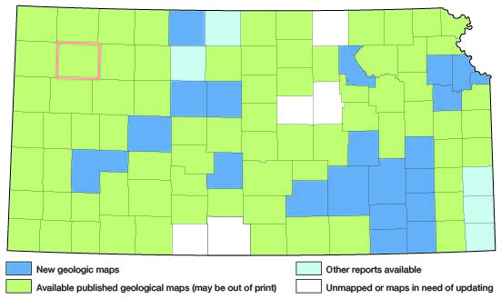
Thomas County is located in the High Plains in the northwestern part of Kansas and is bounded on the north by Rawlins county, on the east by Sheridan county, on the south by Logan and Gove counties, and On the west by Sherman county. Most of the area lies between 39 deg. 8' and 39 deg. 35' north latitude and 100 deg. 44' and 101 deg. 22' west longitude. It contains 30 townships, from T. 6 S., R. 31 W. to T. 10 S., R. 36 W., and has an area of about 1,070 square miles. Thomas County is rectangular in shape and extends about 36 miles east-west and about 30 miles north-south. The location of this county and other areas in which cooperative groundwater investigations have been made are shown in figure 1.
Figure 1--Index map of Kansas showing area described in this report and areas covered by other geologic maps, as of Feb. 2001. For additional information, the KGS Geologic Maps of Kansas Page.
Previous Investigations
A detailed study of the groundwater resources of any northwestern Kansas county has not previously been undertaken. Haworth in 1895 studied the regional geology and water resources of western Kansas (Haworth, 1897); Johnson (1901, 1902), in his report on the utilization of the Southern High Plains, made special reference to the source, availability, and use of ground water in western Kansas; and Darton (1905) made a study of the geology and groundwater resources of the Central Great Plains. A detailed investigation of the geology of Wallace county, adjacent to Thomas County on the southwest, was published by the State Geological Survey in 1981 (Elias, 1931), and a description of the geology and groundwater resources of Rawlins and Decatur counties was published in 1937 (Elias, 1987). A reconnaissance of the Quaternary deposits of northwestern Kansas has been made recently (Leonard and Frye, 1943; Hibbard, Frye, and Leonard, 1944).
Cooperative groundwater investigations have been undertaken in several southwestern Kansas counties (fig. 1). Those published include reports on Stanton county (Latta, 1941), Morton county (McLaughlin, 1942), Ford county (Waite, 1942), Meade county (Frye, 1942), Hamilton and Kearny counties (McLaughlin, 1943), the oil-field areas of Ellis and Russell counties (Frye and Brazil, 1943), and Finney and Gray counties (Latta, 1944).
Methods of Investigation
Six weeks in the summer of 1942, two weeks in 1943, and one week in 1944 were spent by me in the field in Thomas County collecting data for this report. During this time a large number of the wells listed in table 9 were visited and the depths to water level in them were measured. All measurements of water level were made using a steel tape from a fixed measuring point at the top of the well W.W. Wilson measured additional wells in the southwestern part of the county during 1948, and in 1942 and 1943 he made periodic measurements of the observation wells. Subsequently the observation wells were measured by Allan Graffham and Howard Palmer.
During the course of the field work the geology of the county was studied and a geologic map (Pl. 1) was prepared. The character of the materials below the surface was ascertained by the drilling of 29 test holes through the entire thickness of water-bearing sand and gravel and into the Pierre shale. These test holes were drilled with the hydraulic-rotary drilling machine owned by the State and Federal Geological Surveys and operated by Nick Fent and Milford Klingaman. Logs of the test holes were prepared in the field by Fent, and these were later supplemented by microscopic examination of the cuttings. The altitudes of the measuring points in most of the measured wells and of the test-hole locations were determined using a plane table and alidade by a level party headed by Charles K. Bayne. The wells shown on plate 2 were located within the sections by use of the speedometer, and the locations are believed accurate to within about 0.1 mile. The wells are numbered by townships from north to south and by ranges from east to west; within a township the wells are numbered in the same order as the sections. For each well shown on plate 2 the number above the line corresponds to the number of the well in the well tables and the number below the line is the depth to the groundwater table below a fixed measuring point.
Samples of water were collected from 24 wells in the county and chemical analyses of them were made by Howard Stoltenberg, Chemist, in the Water and Sewage Laboratory of the Kansas State Board of Health.
The base map of the county used in plates 1 and 2 was compiled by Dorothea Weingartner from the Colby quadrangle (planimetric map) published by the Federal and State Geological Surveys, aerial photographs from the Agricultural Adjustment Administration of the United States Department of Agriculture, and aerial photographs from the Soil Conservation Service of the United States Department of Agriculture. A map of the county compiled by the State Highway Department was used for field mapping.
Acknowledgments
Thanks and appreciation are expressed to the many residents of Thomas County who supplied information and aided in the collection of field data. Special thanks are extended to the owners of several irrigation wells who permitted pumping tests to be made and to the city officials of Brewster, Colby, and Rexford who furnished information about their respective city wells. George S. Knapp, Chief Engineer of the Division of Water Resources, Kansas State Board of Agriculture, and Elbert Coles, Director of the Colby Experiment Station, supplied measurements made in 1914 and subsequent years and pumping data on a well at the Colby Experiment Station. August Lauterbach assisted me in the field in the measurement of a stratigraphic section of the Ogallala formation. A. Byron Leonard identified fossil snails collected from the Pleistocene deposits and C.W. Hibbard identified fossil vertebrates collected from Pliocene and Pleistocene deposits.
The manuscript for this report has been reviewed critically by S.W. Lohman, O.E. Meinzer, and W.D. Collins of the Federal Geological Survey; J.M. Jewett of the State Geological Survey of Kansas; Paul D. Haney, Director, and Ogden S. Jones, Geologist, of the Division of Sanitation of the Kansas State Board of Health; and George S. Knapp, Chief Engineer of the Division of Water Resources of the Kansas State Board of Agriculture.
Prev Page--Contents || Next Page--Geography
Kansas Geological Survey, Thomas County Geohydrology
Web version Nov. 2001. Original publication date Dec. 1945.
Comments to webadmin@kgs.ku.edu
The URL for this page is http://www.kgs.ku.edu/General/Geology/Thomas/02_intro.html