![]()
Prev Page--Geography || Next Page--Ground Water
Geology
Summary of Stratigraphy
The surface geology of Thomas County is relatively simple. All the rocks that crop out at the surface are sedimentary in origin, are of Quaternary and Tertiary age, and for the most part are unconsolidated. The named formations are listed in table 2, and their areal distribution is shown on plate 1. Cross sections in figures 3 and 4 show the general relationship of the several formations. It will be noted by reference to the geologic map (pl. 1) that somewhat more than 90 percent of the surface area of the county is underlain by deposits of Quaternary age that are assigned to the Pleistocene Sanborn formation and the Recent slope deposits and alluvium. The oldest beds exposed are assigned to the Pliocene Ogallala formation.
Table 2--General section of the geologic formations of Thomas County, Kansas.
| System | Series | Subdivisions | Thickness (feet) |
Character | Water Supply |
|---|---|---|---|---|---|
| Quaternary | Recent | Alluvium | 0-30 | Silt, sand, and gravel along the major stream valleys. Mostly sandy silt but locally poorly sorted sand and gravel. | Yields water to wells only at a few places along such valleys as South Sappa and Prairie Dog creeks. |
| Recent and Pleistocene | Sanborn formation (Pleistocene) and slope deposits (Recent) | 0-65 | Silt, massive, with locally some sand and gravel at base. Slope deposits are silt, sand, and gravel. | Generally above the water table and yields little or no water to wells. | |
| Tertiary | Pliocene | Ogallala formation | 60-275 | Sand, gravel, silt, and clay, some zones cemented with calcium carbonate to form hard "mortar beds." Individual beds generally lenticular. | Yields abundant supplies of water of good quality and is the source of water for nearly all the wells in the county. |
Geologic History and Geomorphology
Paleozoic Era
Rocks of Paleozoic age do not crop out in northwestern Kansas, but many facts concerning them and the Paleozoic history of this region are known from deep tests drilled for oil and gas. The known geologic history of this area starts with erosion of the pre-Cambrian basement rocks that occur below the Paleozoic strata. This ancient erosion surface was submerged below sea level and marine sediments were deposited upon it. Throughout much of Paleozoic time the area was successively submerged and elevated. Marine sediments accumulated during periods when the surface was below sea level, and these deposits were subsequently eroded during periods of emergence. The lower Paleozoic rocks consist for the most part of marine limestone, shale, and sandstone.
Thomas County lies just off the southwest flank of the prominent regional structure in the Paleozoic rocks known as the Central Kansas uplift, and the pre-Cambrian surface below the county is less than 2,500 feet below sea level. According to Moore and Jewett (1942) an important structural event occurred in this area between Devonian and Mississippian deposition. This consisted of a regional arching of the strata along a northwest-southeast axis and is indicated by the fact that pre-Mississippian erosion truncated the earlier Paleozoic rocks and stripped off all the beds down to the Arbuckle limestone. Although data from the immediate vicinity of Thomas County are not conclusive as to such a history, it is inferred from relationships farther east, where many more data are available, that Thomas County is included in the general area of the structure designated as the Ellis arch. This period of uplift and subsequent erosion is believed to have been followed by marine inundation and resulting deposition of the Mississippian strata over this part of Kansas.
The rocks of northwestern Kansas were again uplifted and warped along this same general structural trend at the close of Mississipian time or during early Pennsylvanian time to form the structural feature now recognized as the Central Kansas uplift. Moore and Jewett (1942) show that this structure in the central part of Kansas is nearly coincident with the earlier structure they designated as the Ellis arch. In the northwestern part of the state, however, they indicate that the two structures do not occupy the same location. The Ellis arch trended to the west-northwest across this part of the state and included all of Thomas County, but the Central Kansas uplift trends north-northwest and includes the northeastern corner of Sheridan County to the east of Thomas County.
The Mississippian strata believed to have existed across the top of the Central Kansas uplift were largely stripped away by early Pennsylvanian erosion, but more than 250 feet of these rocks remain beneath Thomas County. Coarse clastic sediments accumulated along the flanks of the uplift as a result of this period of erosion, and it is believed that they may have been contemporaneous with the denudation deposits that were spread out toward the east from the ancestral Rocky Mountains.
The sea again invaded the area and marine deposits accumulated across all of northwestern Kansas during Pennsylvanian time. During the latter part of the Paleozoic, marine conditions were less prevalent and at times sediments accumulated on the surface of the land. Thus marine and nonmarine deposits occur alternately throughout rocks representing upper Pennsylvanian and Permian time. Evaporites and nonmarine sediments became more prevalent throughout Permian time, indicating an intermittent but progressive withdrawal of the sea.
Geologic History and Geomorphology
Mesozoic Era
The sea withdrew completely from the area by the close of Paleozoic time and the surface was eroded, uplifted, and warped. Erosion proceeded throughout much of Triassic time and at least part of the area again received deposits during part of Jurassic time. Landes and Keroher (1939, p. 25) have described the subsurface geology of Logan, Gove, and Trego counties to the south of Thomas County and stated concerning these Jurassic deposits:
The shale section 100 to 200 feet thick which immediately overlies the Permian, in some places, has been tentatively correlated with the Morrison formation. The age of this formation has not been exactly determined, but evidence based on paleontology strongly indicates that it is Jurassic. These rocks consist predominantly of green shale with an abundance of pink jasper-like chert. Translucent pink gypsum occurs near the base. An interesting zone of doubly terminated quartz crystals which was noted in a number of wells may prove to he useful in correlation. An unconformity at the base of the Jurassic (?) rocks marks the top of the Permian system. Due to the lithologic change in the rocks this unconformity is easily recognized and therefore is a valuable correlation point for geologists.
An erosion interval followed the deposition of these supposed Jurassic deposits and this general area probably stood above sea level during part of Jurassic time and the early part of Cretaceous time. As the early Cretaceous sea inundated this area, clastic sediments accumulated at and near the shore line as beach deposits deltas, and offshore bars. The sea completely inundated this area and marine sediments were laid down. Nonmarine conditions probably again existed throughout part of the time of deposition of the Dakota formation, and then the sea completely transgressed the area for the last time and the Graneros shale and overlying marine formations of Upper Cretaceous age were deposited. That this area gradually subsided throughout Upper Cretaceous time is indicated by the presence of more than 2,000 feet of fine-textured shallow-water Upper Cretaceous deposits. These strata consist of chalk and chalky limestones (Greenhorn limestone and Niobrara chalk) alternating with shale and calcareous shale (Graneros shale, Carlile shale, and Pierre shale).
Geologic History and Geomorphology
Cenozoic Era
Tertiary period
Erosion and deposition--Thomas County, as a part of the Great Plains, must be considered in the light of events affecting the general region lying east of the Rocky Mountains. Since the withdrawal of the Cretaceous sea this area has been continually above sea level, and during early Tertiary time much of the Great Plains region was subjected to subareal erosion. There was extensive uplift in the Rocky Mountain area and streams flowing outward from this region crossed the Great Plains. Deposition of clastic sediments started at an earlier time in the northern part of the plains region than it did in Kansas. In Nebraska sediments of the White River group were deposited in Oligocene time and the Arikaree and Hemingford groups were deposited during Miocene time (Lugn, 1939, p. 1,264) prior to Tertiary deposition in northwestern Kansas. The oldest Tertiary deposits in the vicinity of Thomas County are classed as being part of the Ogallala formation and are believed to be of Pliocene age.
The Tertiary beds of western Kansas were first thought to represent lake deposits (Hay, 1890; Williston, 1895), but a half century ago they were demonstrated to be of fluviatile origin (Gilbert, 1896; Haworth, 1897; Johnson, 1901). Smith (1940, pp. 77, 78) has stated of the Ogallala:
In the light of present knowledge, the Ogallala may be described as a warped and dissected piedmont alluvial plain deposit. It is not to be regarded as a composite fan deposit as supposed by some workers, however, for its thickness increases away from the mountain front, whereas that of a fan deposit decreases outward from a point near its apex.
Streams flowing outward from the mountain area carried debris eroded from the highlands and deposited this material as a complex sequence of lenticular and sheet-like bodies of gravel, sand, silt, and clay. The surface upon which the Ogallala was deposited was a plains area having a topography of low relief, and the deposits of these streams not only filled their shallow valleys but spread also across the divides.
Events terminating Ogallala deposition--At the close of the period of deposition of the Ogallala formation the aggradational plain in the Great Plains region merged with an erosional plain in the Rocky Mountain region. Fenneman (1931, p. 107) has summarized the conditions at this time as follows:
It may be assumed that at the close of the later cycle the greater part of this province and others adjacent were covered by a continuous graded plain, made by degradation of the mountains and aggradation of the Great Plains. The peneplain in the mountain province is believed to correspond in geologic date with the surface of the Pliocene sediments that now cover the High Plains.
This plain of aggradation that covered northern Kansas completely obliterated all preexisting topography. Such Cretaceous strata as the Fort Hays limestone member of the Niobrara formation and the Greenhorn limestone that now form prominent escarpments along their belts of outcrop were blanketed by at least a thin veneer of Tertiary sediments.
At many places a distinctive hard bed of limestone occurs at the top of the Ogallala. This limestone was described by Elias (1931, pp. 136-141) and named the "Chlorellopsis limestone' or "Algal limestone" from the presence of abundant remains of the alga Chlorellopsis bradleyi Elias. Wherever observed in northwestern Kansas and Nebraska, this limestone bed marks the top of the Ogallala formation. Elias (1931, p. 141) believed that "...this rock was deposited on the nearly flat bottom of a very large and very shallow lake at the close of Ogallala time." Smith (1940, pp. 90-92) raised some questions about the proposed lacustrine origin of the "Algal limestone," and Theis (1936) has attributed the origin of the capping limestone in the area south of Kansas to small lakes produced by the flooding of shallow depressions by a rising water table. A previously unknown occurrence of "Algal limestone" that seems to have some significance concerning the origin of the bed was discovered in east-central Russell County (center east line sec. 8, T. 14 S., R. 11 W.) on the highest part of the divide between the Saline and Smoky Hill rivers. At this locality somewhat less than 10 feet of Ogallala beds, consisting mostly of "Algal limestone," is exposed directly in contact with chalky shales of the upper part of the Cretaceous Greenhorn limestone. The abandoned Wilson valley (Frye, Leonard, and Hibbard, 1943), which is cut completely through the Greenhorn and underlying Graneros shale, occurs a short distance to the east of this locality. This exposure has been visited by Elias who identified the beds as "Algal limestone." The locality is remote from other exposures of the Ogallala formation, the nearest being 35 miles to the west in northern Ellis County where it overlies the Fort Hays limestone member of the Niobrara chalk. As this newly discovered exposure of "Algal limestone" is located on top of an upland divide underlain by the Greenhorn limestone, it demonstrates that the outcrop of the Greenhorn, like that of the Fort Hays, was reduced to the general level of the aggradational plain at the close of the period of Ogallala deposition.
At the end of Ogallala deposition, when the streams were no longer spreading sediments in the area and before they had started to dissect the surface of this plain, the channels probably shifted laterally. Stream channels at various times may have occupied most points on this surface. Such lateral shifting of channels would result in the formation of many lakes, for the most part disconnected and occupied by standing water. The water table may have stood at such a level that these lakes were all "water table lakes." Such lakes, consisting of abandoned channel segments and consequent depressions on a plain of alluviation, would meet the environmental requirements stipulated by Elias (1931, p. 141) for the development of the "Algal limestone" without recourse to the complicated diastrophic movements objected to by Smith (1940, p. 91).
Quaternary period
Post "Algal limestone" erosion--A diastrophic event of major importance occurred in northwestern Kansas after the deposition of the "Algal limestone." As has been pointed out, the streams shifted laterally over the Ogallala deposits, modifying or destroying the former drainage pattern. After the time of deposition of the "Algal limestone" the major streams, in whatever position they happened to occupy, started to entrench their channels through their former deposits and, in those areas where the Ogallala was quite thin, into the underlying bedrock. The causes for this period of erosion are complex and probably include both differential uplift and climatic changes.
Smith (1940, pp. 80-85) reviewed the paleophysiography of the Ogallala formation and after discussing several possible hypotheses stated as follows (p. 84):
Remaining ... is the hypothesis of an originally more or less even depositional plain of low latitudinal gradient, subjected later to strong differential tilting. This tilting must have been very moderate along the present Platte and Arkansas valleys, and comparatively steep along the divide between them, the amount of uplift progressively increasing toward the mountains. The Ogallala surface was probably affected as far eastward as the western third of Kansas. The semi-radial drainage pattern of the central high Plains constitutes supporting evidence for this hypothesis, being best explained as of consequent origin on an upwarped depositional surface.
Although this period of erosion produced the most important disconformity within the Cenozoic deposits of northwestern Kansas, the exact time of the event is not definitely known. The Pliocene-Pleistocene time line generally used in North America is based largely on glacial deposits, and in the High Plains area there are many problems concerning its correlation (Frye, 1945). Present data indicate that this erosion period started before the beginning of Pleistocene time as generally used.
Pleistocene deposition--Alluvial deposits began to accumulate in the valleys of the major streams in northwestern Kansas after the initial entrenchment of the streams in the Tertiary deposits. Elias (1931, p. 163) named these alluvial deposits and the overlying silt or loess the Sanborn formation. Sand and gravel comparable to the lower part of the Sanborn were not deposited widely over Thomas County, and it is probable that no major through-flowing stream from the Rocky Mountain region crossed this county during the Pleistocene epoch. To the southwest in Wallace County, however, coarse gravel which contains boulders with a maximum diameter of as much as 2 feet (Elias, 1931, p. 163; Hibbard, Frye, and Leonard, 1944, p. 25) has been described as occurring above the base of the Pleistocene deposits. A history of successive periods of stream erosion and deposition during the Pleistocene is recorded in the terraces of the major valleys east of Thomas County (Frye, Leonard, and Hibbard, 1943), but if the few scattered gravel deposits of Pleistocene age in Thomas County are of more than one age, the several ages have not been differentiated.
Late in the Pleistocene a thick mantle of silt was spread over this region. This extensive bed of silt is generally called loess, and it seems probable that its deposition was in large part due to wind action. However, it probably has been modified by the action of sheet and rill wash. Stream-deposited silt generally overlies the sand and gravel of the terrace deposits of central and northwestern Kansas. The position of the massive silt on the upland-divide areas indicates that this extremely well-sorted material was blown to its point of deposition by wind. Rainwaters probably have been an important factor in shifting this silt from place to place and washing it into the shallow upland depressions common throughout the upland areas.
Slope processes of creep, sheet wash, slump, and others have been important in moving large quantities of material down the present valley sides. The existing slope deposits are Recent in age and probably developed contemporaneously with the development of alluvium along the major valleys. The slope processes have most likely been the major factor in widening the valleys, lateral planation by the streams having been of small importance.
Development of present topography--The topography of Thomas County, although relatively flat, cannot be said to be completely featureless (pls. 3A and 3B). The major valleys are relatively broad and in some places exhibit a distinct asymmetry of cross section which seems to be related to the weathering and retreat of slopes rather than to the excessive cutting of the streams along one bank. Such valleys as Prairie Dog and Sappa in the north-central part of the county are notably steeper on their south sides than on their north sides. This same relation is exhibited in the cuts along the Rock Island Railroad near Levant (pl. 6C). Along such valleys the steeper south slopes generally afford exposures of the Ogallala formation whereas these beds are completely mantled by slope deposits on the more gentle north slopes.
Plate 3--A, Valley of South Sappa creek. northeastern Thomas County. B, High Plains, NE sec. 19, T. 6 S., R. 33 W., looking east. C, Silt of the Sanborn formation along the valley of South Sappa creek, near Rexford.
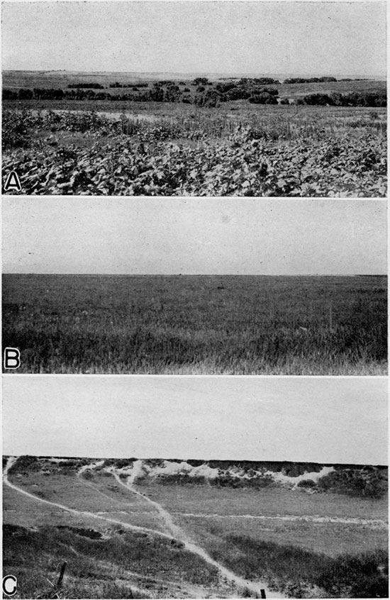
The most distinctive aspect of the topography of the county probably is the large number of depressions that dot the surface of the uplands and in some places occur on intermediate levels (pls. 5A and 6A). These depressions are of various sizes but in no case do they assume the size of the large solutional-subsidence areas of southwestern Kansas such as the Ashland-Englewood basin (Frye and Schoff, 1942). The origin of these depressions presents a perplexing problem. As can be seen from the location of intermittent ponds on plate 1, depressions occur generally over the county but are more abundant in the western half. Although not apparent on the map, at some localities there are definite alignments of shallow depressions and in some places these alignments are along shallow valleys.
Plate 5--A, Undrained upland depression, sec. 25, T. 6 S., R. 35 W., looking northeast. B, Hill of the Ogallala formation protruding through Sanborn formation and valley side deposits north of Brewster, SW sec. 7, T. 8 S., R. 36 W. The "Algal limestone" marks the top of the Ogallala in this area. C, Hydraulic-rotary test drill in operation at lest hole 12, southeast of Halford,.
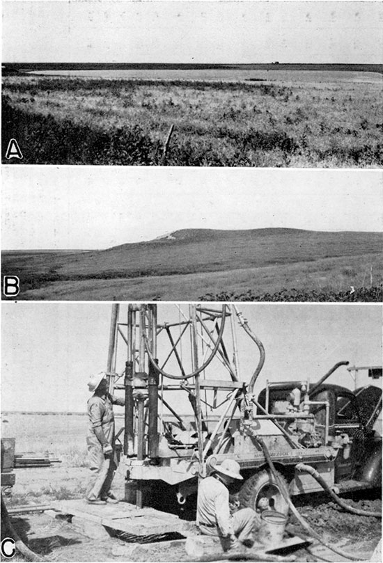
Two of these depressions were selected for testing in an attempt to learn something concerning their origin. Test holes were drilled in each of these near the center of the depression and on each side of the rim, the results of which are shown in figure 4. It will be noted that there is no reflection of the surface depression in the bedrock floors beneath them, and in one case the surface of the Pierre shale is higher below the center of the depression than under the adjacent rim. These data, together with the fact that in the western part of the county about 1,000 feet of shale occurs below the surface of the bedrock floor and above the shallowest soluble bed, seem to demonstrate that these depressions are not due to solution-subsidence but may be due to some other cause unrelated to the bedrock below the Tertiary sediments.
Darton (1915, pp. 86, 37) referred to some of these High Plains depressions as "buffalo wallows" and explained their origin by the action of buffalos and wind. He believed the depressions were started by buffalos, either at wet, salty, or alkali spots, and that they were excavated by tramping hoofs followed by wind scour and also by mud sticking to the shaggy coats of the animals during wet periods. Although this hypothesis might account for some of the small shallow depressions, it hardly seems adequate for the large depressions having depths of 10 feet or more.
Johnson (1901, pp. 702, 712) discussed at some length the origin of High Plains basins. For the large irregular basins in the area of Permian bedrock he advocated an origin by solution of soluble beds of the Permian followed by collapse of the overlying beds and development of surface depressions. In the area of Cretaceous bedrock he recognized the inadequacy of this hypothesis, especially for the small shallow round or oval depressions. These range in size from the small features referred to as "buffalo wallows" to large areas of more than half a mile in diameter. Johnson pointed out the inadequacy of wind scour, as these low places held water for long periods and thus would be points of accumulation rather than areas of erosion of eolian sediments. He also pointed out that such features could not originate as initial irregularities on a depositional surface.
Johnson's hypothesis of origin for these features is as follows (1901, pp. 703, 704):
"Appearances indicate basining of the alluvial surface as a consequence, first, of rainwater accumulation in initial faint unevenness of the plain; second, of percolation of this ponded surface water downward to the ground water in largely increased amount from these small areas of concentration, rather than from over the whole surface uniformly, with the result that the alluvial mass is appreciably settled beneath the basins only. The inference is at once suggested that this settlement takes place as the combined effect of mechanical compacting of the ground particles and chemical solution of the more soluble particles. Finally, these effects should be cumulative, resulting in the growth noted, since, with enlargement of the basins, concentration of rainwater within them will be on an increased scale.
"Over comparatively small areas surface effects should be symmetrical, but beneath basins of great breadth--and some have breadths of several miles--the depths of settlement at points wide apart within the same basin, as well as the conformation of the basin rims, should reflect the broader variations of structure beneath. Depths should be least above beds of clay and greatest over areas of coarse channel deposits."
Although Johnson's hypothesis, proposed more than 40 years ago, has not been widely accepted and is very difficult to demonstrate, it nevertheless seems to explain the data concerning the types of depressions found in Thomas County more adequately than any other idea so far expressed. Many depressions, or sinks, that are clearly the result of solution and subsidence are known in other parts of the High Plains. Johnson recognized this fact and did not attempt to stretch his localized compaction hypothesis to cover such features.
Prev Page--Geography || Next Page--Ground Water
Kansas Geological Survey, Thomas County Geohydrology
Web version Nov. 2001. Original publication date Dec. 1945.
Comments to webadmin@kgs.ku.edu
The URL for this page is http://www.kgs.ku.edu/General/Geology/Thomas/04_geol.html