![]()
Prev Page--Introduction || Next Page--Geology
Geography
Topography and Drainage
Thomas County lies entirely within the area designated by Fenneman (1931) as the High Plains section of the Great Plains physiographic province. The county consists of nearly flat to gently rolling uplands broken by relatively shallow valleys. The upland-plains surface generally slopes eastward at a rate of somewhat more than 12 feet to the mile. The lowest point in the county is along the valley of Prairie Dog creek where that stream crosses the Sheridan county line, and has an altitude of about 2,845 feet. The highest area in the county is along the Sherman county line south of Brewster where the upland surface attains an altitude of as much as 3,375 feet.
Although the general region of which Thomas County is a part is called the High Plains, it has some of the features of a plateau--that is, it is essentially a flat upland surface that stands distinctly above the surrounding regions. The High Plains are terminated eastward in parts of central Kansas by an escarpment produced by the eroded edge of the Fort Hays limestone member of the Niobrara chalk. At some places a second east-facing escarpment, produced by the loosely cemented conglomerates of the Ogallala formation, occurs to the west of the outcrop of the Fort Hays. A less distinct west-facing escarpment, also formed by the eroded edge of the Ogallala formation, can be seen due west of Thomas County in eastern Colorado. South of Thomas County the High Plains upland stands above the dissected area comprising the Smoky Hill valley.
Thomas County contains the headwater areas of several important streams flowing across northwestern and north-central Kansas. The north and south forks of the Saline river and the north and south forks of the Solomon river, streams that drain most of north-central Kansas and empty into the Smoky Hill river in Saline county, and Prairie Dog creek, an important southern tributary to the Republican river, all originate in Thomas County. In addition to these streams North and South Sappa creeks which originate to the west in Sherman county flow across the northwestern and north-central parts of Thomas County and are also important southern tributaries to the Republican River. The streams of Thomas County make a fan-shaped pattern, originating for the most part in the area south and east of Brewster and diverging toward the north and east. This divergence gives an east-northeasterly course to all the streams of the county with the exception of the Saline River and South Fork of the Solomon River.
In spite of the large number of important streams that originate in or flow across this county, it is not well supplied with surface water and parts of it are not well drained. No stream in the county contains flowing water during dry weather, and, with the exception of South Sappa creek north of Gem and the Saline River east of Oakley, the stream channels contain flowing water only during and after rains. At many places along these channels, however, small ponds contain water for weeks after the streams have ceased to flow.
The upland areas are not everywhere well drained because of their excessive flatness and the presence of shallow depressional areas. Some of these depressions are more than 10 feet deep and contain water several weeks after rains, whereas others are quite shallow and hold ponds only during and immediately after rains.
Climate
Thomas County lies in a region only moderately supplied with rainfall but well supplied with sunshine. The climate is of the sub-humid to semiarid type involving slight to moderate precipitation, moderately high average wind velocity, and rapid evaporation. During the summer the days are hot, but the nights are generally cool and comfortable. The hot summer days are alleviated by good wind movement and low relative humidity. As a rule the winters are characterized by moderate weather with severe cold periods of short duration and relatively little snowfall.
The average mean annual temperature at Colby is 51.8 degrees F. In general the hottest month is July with an average temperature of 76.0 degrees F. for 33 years of record, and the coldest month is January with 28.6 degrees F. The average growing season--that is, the interval between the last killing frost in the spring and the first killing frost in the fall--is about 159 days. The average date for the last killing frost in the spring is May 1 and for the first killing frost in autumn is October 7. The latest date for a killing frost in the spring has been May 26 and the earliest in the fall has been September 7.
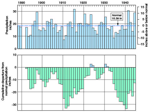
The normal annual precipitation at Colby determined by the U.S. Weather Bureau is 18.39 inches and the average since the beginning of record is 17.95 inches. The range in amount of annual rainfall since 1888 is 25.20 inches. The smallest precipitation of any year of record was in 1910 when only 6.61 inches was recorded at Colby and the greatest of record was that of 1915 when 31.81 inches was recorded. The bulk of the rainfall occurs during the growing season, when the average precipitation for this six-month period in this part of Kansas is approximately the same as that in the Dakotas, and three-fourths of the average for Illinois, Indiana, or Ohio.
The annual rainfall for the period of record and the cumulative departure from normal are shown in figure 2. Although the annual rainfall seems to present an irregular pattern, the cumulative departure from normal has a roughly cyclic pattern of recurrent wet and dry periods. The shape of the graph rather than the area above or below the normal line is the significant feature as the placement of the curve with respect to normal is largely influenced by conditions at the beginning of the period of record.
Figure 2--Annual precipitation and cumulative departure from normal precipitation at Colby. A larger version of this figure is available. (From records of the U.S. Weather Bureau.)
Population
According to the 1940 census, the population of Thomas County was 6,425, an average of 6.0 people per square mile as against 21.9 for the entire state. The population has fluctuated in recent years as shown by the census figures for 1920 and 1930 which were 5,517 and 7,834, respectively. In 1940 more than half the residents of the county lived in five cities. Colby, the county seat and largest city in the county, had a population of 2,458. The Census Bureau lists population figures for four other cities in 1940: Brewster, 408; Rexford, 244; Menlo, 144; and Gem, 125.
Transportation
Thomas County is crossed by the main line of the Chicago, Rock Island, and Pacific Railroad from Chicago to Denver, which traverses the county east to west through Rexford, Gem, Colby, Levant, and Brewster. A branch line of the Union Pacific Railroad enters from the east at Menlo and runs westward through Halford to Colby; from Colby this line runs southeastward through Mingo to Oakley, where it connects with the main east-west line of the Union Pacific Railroad.
Several hard-surfaced Federal and State highways pass through Thomas County. U.S. highway 24 crosses east-west about midway from north to south and passes through Menlo, Halford, Colby, Levant, and Brewster. U.S. highway 83 enters the county from the northeast at Rexford and passes southward through Halford to the county line. The remainder of the county is served by numerous improved county and township roads (pl. 1).
Agriculture, Natural Resources, and Industries
Agriculture is the chief occupation in Thomas County. In 1940 virtually all the land was in farms. According to the sixteenth U.S. census, in 1939 there were 955 farms having an average size of 735.8 acres. The principal crop is wheat, and Thomas County has been one of the leading producers in the state during recent years. The principal uses of land in 1939 as reported by the U.S. Census Bureau are given in table 1. Although 1939 may not be a typical year for the county, it is the most recent year for which figures are available.
Table 1--Acreage of principal land uses in Thomas County in 1939. (Data from the U.S. Census Bureau)
| Use | Acres | Percent |
|---|---|---|
| Wheat threshed | 129,560 | 18.5 |
| Sorghums | 38,004 | 5.4 |
| Barley threshed | 29,496 | 4.2 |
| Small grain hay | 5,408 | 0.8 |
| Idle or fallow | 194,823 | 27.8 |
| Crop failure | 106,361 | 15.1 |
| Plowable pasture | 101,809 | 14.5 |
| Woodlands | 795 | 0.1 |
| All other lands | 88,836 | 12.7 |
Agriculture, natural resources, and industries have been grouped together for consideration because of the complete overshadowing by agriculture of all other enterprises in the county. No other important industries exist here except as a service to agriculture. The paramount natural resources are the deep and fertile soil and the underground water, a discussion of which occupies many of the succeeding pages of this report. Some sand and gravel are produced for road surfacing and building purposes. Exploration for oil and gas has been carried on in the county and, as rocks that produce these substances elsewhere in the state are known to occur at considerable depth below the surface of Thomas County, it is not unreasonable to expect that continued exploration may be rewarded with a measure of success.
Prev Page--Introduction || Next Page--Geology
Kansas Geological Survey, Thomas County Geohydrology
Web version Nov. 2001. Original publication date Dec. 1945.
Comments to webadmin@kgs.ku.edu
The URL for this page is http://www.kgs.ku.edu/General/Geology/Thomas/03_geog.html