![]()
Prev Page--Ground-water Utilization, Quality || Next Page--Well Records
Geologic Formations in Relation to Ground Water
Cretaceous System (Gulfian Series)
Dakota Formation
The Dakota Formation does not crop out in Gove County but it contains ground water within a practical drilling depth and should be considered in a discussion of the aquifers of the county. In nearby Trego and Rooks counties the Dakota is an important source of ground water in certain areas where shallow ground water is scarce, and in Logan County a well in the NW sec. 6, T. 13 S., R. 33 W., obtains water from the Dakota Formation for stock use (Johnson, 1958). Data were obtained on six water wells in Gove County that were drilled to the Dakota Formation, mostly in the southeastern part of the county. At the time of this investigation, four of the wells were being used and two were abandoned because of pumping difficulties.
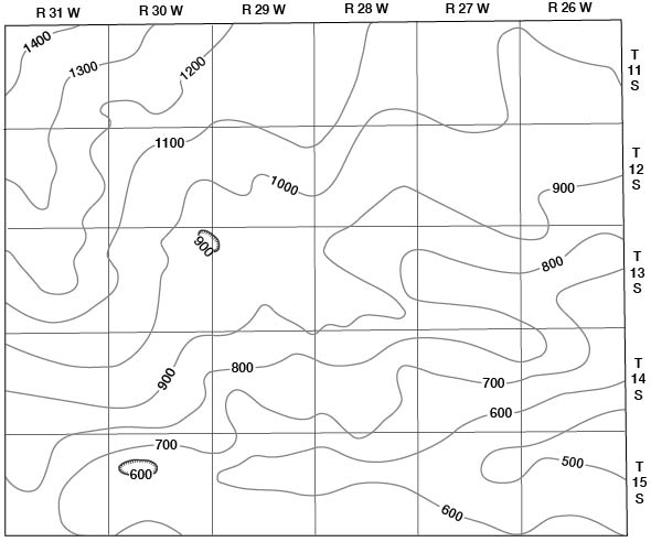
The Dakota Formation in Kansas consists predominantly of clay, shale, siltstone, and lenses of fine- to medium-grained sandstone. Although the Dakota is predominantly clay (Plummer and Romary, 1942), sandstone lenses occur throughout the formation, and water-bearing sandstone can be expected at any locality. The thickness of the Dakota Formation is about 250 feet in Gove County. The depth below land surface to the top of the Dakota ranges from about 500 feet in the southeastern part of the county to about 1,400 feet in the northwestern part (Fig. 16). Water within the Dakota Formation is under artesian pressure in Gove County and although the water does not flow at the surface the water level rises considerably in the wells. In a well in the SE sec. 14, T. 14 S., R. 26 W., water from the Dakota rises to 276 feet below the land surface and in the NW sec. 21, T. 13 S., R. 30 W., water rises within 445 feet of the surface. Because of the discontinuity of sandstone lenses in the Dakota, wells fairly close together may differ in depth to water, artesian head, and quality of water.
Figure 16--Generalized contours showing depth of Dakota Formation below land surface. Interpolated from structure and convergence maps by Merriam and Frye (1954) and from logs of oil and gas test wells. Contour interval 100 feet.
Analyses of water samples from two wells deriving water from the Dakota Formation in Gove County indicate that water from the Dakota contains more than 350 ppm of sodium but is suitable for domestic and stock use.
Graneros Shale
The Graneros Shale overlies the Dakota Formation and is about 45 feet thick in Gove County. The Graneros Shale consists principally of dark blue-gray shale; thin layers of bentonite are characteristic, and locally it contains thin lenses of ferruginous sandstone. The Graneros Shale is not known to yield water to any wells in Gove County.
Greenhorn Limestone
The Greenhorn Limestone overlies the Graneros Shale and is about 100 feet thick in Gove County. The Greenhorn Limestone consists chiefly of alternating beds of chalky limestone and calcareous shale. The Greenhorn is not known to yield water to any wells in Gove County.
Carlile Shale
The Carlile Shale overlies the Greenhorn Limestone and is about 250 feet thick in Gove County. The lower two-thirds (Fairport Shale member) consists chiefly of gray to blue-gray calcareous shale and thin beds of chalky limestone. The upper one-third (Blue Hill Shale member) consists of dark-gray clayey shale, at the top of which is silty, fine-grained sandstone a few feet thick called the Codell Sandstone zone. The Codell Sandstone zone is typically variable in both thickness and lithology. It is reported in the subsurface in Gove County by drillers as a thin sandy zone at the "between the shales" break. Wells 14-27-12cd and 15-2636ba2 are believed to derive water from the Codell, although it is possible that some water also comes from the overlying Fort Hays Chalk member of the Niobrara Chalk. Reported yields from these wells are low; the quality is poor but the water is useable.
Niobrara Chalk
The Niobrara Chalk, chiefly the Smoky Hill Chalk member, crops out in much of the southern and east-central part of Gove County along the valleys of Smoky Hill River and Hackberry Creek and their tributaries. The Niobrara consists of about 700 feet of beds of light-gray chalk, chalky limestone, and chalky shale, the lower part of which (Fort Hays Chalk member) is massive chalk or chalky limestone about 65 feet thick. Many thin beds of bentonite occur throughout the Niobrara; neither sand nor noncalcareous shale is present. A pair of bentonite seams near the top of the uppermost thick chalk bed marks the boundary between the Fort Hays Chalk member and the overlying Smoky Hill Chalk member.
Fort Hays Chalk member--The oldest rocks that crop out in Gove County consist of massive chalk beds of the Fort Hays Chalk member, of which only the uppermost part is exposed in the county. The Fort Hays crops out in the extreme eastern part of the county along the edges of the inner valley of Smoky Hill River and is buried beneath the Smoky Hill Chalk, upper member of the Niobrara Chalk, in the rest of the county. The Fort Hays is distinguished from the overlying Smoky Hill by the predominance of massive beds of chalk and chalky limestone characteristic of the Fort Hays. These beds generally are about 3 to 6 feet thick and are separated by thin chalky shale partings. The Fort Hays is grayish white but generally weathers yellow or light brown. Because the Fort Hays is more resistant to erosion than the overlying Smoky Hill Chalk member or the underlying Carlile Shale it generally forms cliffs.
The Fort Hays Chalk Member is not known to yield water to wells in Gove County although some of the water from wells 14-27-12cd and 15-26-36ba2 may be derived from fractures or bedding planes within the Fort Hays rather than from the underlying Codell Sandstone zone.
Smoky Hill Chalk member--The Smoky Hill Chalk member consists principally of chalky shale and chalk. It is characteristically thin bedded and platy in structure although massive beds occur locally. The Smoky Hill Chalk member is light to dark gray but weathers colorfully to white, yellow, pink, and brown. Concretions of limonite and pyrite and veins of gypsum are common, and thin beds of bentonite occur throughout. Locally, chalk of sufficient porosity has been replaced by chert to form silicified zones. The chert has been precipitated from silica dissolved from the overlying Ogallala Formation by ground water.
The Smoky Hill Chalk member is notable for its effect on topography. Soil is thin or absent, vegetation is sparse, and rain wash and gully erosion have produced winding canyons and barren rocky ridges in much of the outcrop area.
The Smoky Hill Chalk member has long been famous for the abundant vertebrate and invertebrate fossils it contains. Vertebrate fossils include aquatic reptiles, such as mosasaurs and plesiosaurs, and many genera and species of fish. The Smoky Hill also contains abundant invertebrate fossils. Minute shells of foraminifera belonging mainly to the families Globigerinidae and Textularidae compose much of the chalk. Most larger invertebrates belong to the Mollusca and Echinodermata, the most numerous of which are the clams Inoceramus platinus and Ostrea larva.
The Smoky Hill Chalk member is more than 600 feet thick in northwestern Gove County but thins toward the east, owing to pre-Pliocene erosion. Smoky Hill River and its tributaries have stripped off a considerable part of the Smoky Hill Chalk member in the southern part of Gove County, and along the inner valley, in southeastern Gove County, the whole member has been removed, exposing the underlying Fort Hays.
The Smoky Hill Chalk member is a poor aquifer in Kansas and yields very little water to wells in Gove County. It is relatively impervious except in small local silicified zones and along fractures. A few wells may obtain some ground water from fractured zones in the faulted area in the southwestern part of Gove County, although most of the water is obtained from colluvium. The driller of irrigation well 12-26-11bb2 reported a cavernous siliceous zone in the lower 3 feet of this well, in the upper part of the member. Because the silicified zones are generally thin and of small lateral extent, only small water yields should be expected.
Pierre Shale
The Pierre Shale conformably overlies the Niobrara Chalk and consists chiefly of dark-gray to black, thin-bedded shale that weathers gray and coffee brown. Thin beds of bentonite are scattered throughout the formation, selenite crystals are abundant, and thin chalk beds occur locally. The Pierre Shale crops out in a down-faulted area in T. 13 and 14 S., R. 31 W., but is restricted to the subsurface in the northwestern part of Gove County where its thickness ranges from a feather edge at its eastern limit to about 150 feet at the west county line (Pl. 3, A-A'). The Pierre Shale is relatively impervious and is of no consequence as an aquifer in Gove County. Where overlain by unconsolidated Tertiary deposits as in northwestern Gove County, the Pierre Shale, like the Smoky Hill Chalk, serves as an impervious layer underlying water-bearing sediments and retards or prevents the downward percolation of ground water.
Tertiary System (Pliocene Series)
Ogallala Formation
The Ogallala Formation was named by Darton (1899) from exposures in Southwestern Nebraska. In 1920 Darton designated the type locality as being near Ogallala Station in western Nebraska. Since the work of Darton, the most significant studies of the Ogallala in western Kansas have been by Elias (1931), Smith (1940), and Frye, Leonard, and Swineford (1956). The Ogallala Formation is believed by the State Geological Survey of Kansas to range from early Pliocene, or possibly late Miocene, to late Pliocene in age. It is subdivided into three members in ascending order, the Valentine, Ash Hollow, and Kimball. A thin discontinuous bed of pisolitic limestone, commonly 1 to 3 feet thick, forms the top of the Ogallala. No attempt was made to subdivide the Ogallala Formation in Gove County.
Character--The Ogallala was deposited chiefly by eastward-trending streams whose source areas were underlain by igneous rocks of the Rocky Mountains and sedimentary rocks of eastern Colorado. The Ogallala Formation constitutes a widespread mantle of fluviatile deposits consisting predominantly of unconsolidated sand, gravel, silt, and clay but also containing thin beds of volcanic ash, fresh-water limestone, and bentonitic clay. Calcium carbonate is a common constituent as a cementing material in hard gritty beds called "mortar beds" or as caliche beds and nodules. Silica also serves as a cementing material in beds of opaline sandstone and forms chert deposits. Sand is the principal constituent throughout the Ogallala Formation. Beds of sand may be uniform but generally the sand ranges from fine to coarse and commonly is mixed with gravel, silt, or clay. Gravel beds containing lenses of sand, silt, and clay are common but thick beds of uniform gravel are scarce. Silt, sandy silt, and clay beds occur throughout the Ogallala and are greenish gray, pink, tan, and gray, or if the beds contain a large amount of calcium carbonate, they are light gray or white.
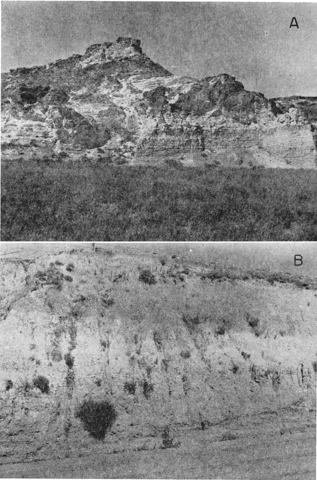
Despite the diversity of deposits, the outcrop pattern of the Ogallala presents a uniformity of aspect that makes the formation readily identifiable. Many beds in the Ogallala are cemented or partly cemented with calcium carbonate. Ogallala "quartzite" is another distinctive type of rock in the formation. The "quartzite" consists of sand and gravel beds cemented with opaline silica into a very hard rock. Where the sand is fine or medium, the interstices are almost filled with cement and the rock resembles true quartzite. Where the rock contains coarse sand or gravel it has little resemblance to quartzite except in respect to hardness. The quartzite occurs close to the base of the Ogallala. The siliceous cementing material of the quartzite is believed to have been leached from overlying volcanic ash beds. Because the cemented beds are more resistant to erosion, most outcrops of the Ogallala form rough benches, hard ledges, and cliffs; exposed surfaces commonly have a knobby, irregular aspect (Pl. 6A).
Plate 6--Tertiary and Quaternary deposits in Gove County. A, Outcrop of Ogallala Formation in NW NW sec. 12, T. 14 S., R. 26 W. B, Eolian silts, classified as Peoria and Loveland formations, in SE SW sec. 35, T. 15 S., R. 29 W.
Distribution and thickness--The Ogallala Formation rests on an erosional topography developed on Cretaceous bedrock; relief is about 500 feet in Gove County (Fig. 17). The Ogallala is thickest in the northern part of the county; it becomes thin and discontinuous in the central part of the county and is missing in almost all the southern part. It caps a few high interstream areas in the extreme southeastern and southwestern parts of the county and caps isolated buttes in sec. 28, T. 14 S., R. 30 W., and in sec. 33, T. 13 S., R. 31 W. (Pl. 1). The Ogallala, although generally mantled with eolian silts, underlies the upland plain in the northern part of Gove County and crops out along the valleys of Hackberry Creek and Big Creek and their tributaries. Tributaries of Saline River have exposed the Ogallala at places along the northern edge of the county.
Figure 17--Map of northern part of Gove County showing configuration of Cretaceous bedrock surface beneath unconsolidated Tertiary and Quaternary deposits. Contour interval 50 feet. A larger version of this figure is available.
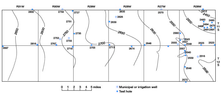
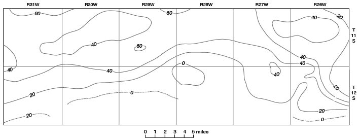
Figure 18--Saturated thickness of Tertiary and Quaternary deposits in Gove County. Contour interval 20 feet. A larger version of this figure is available.
Smoky Hill River in Gove County runs near and approximately parallel to a pre-Ogallala divide, or bedrock high. The bedrock slopes downward from each side of this divide, hence deposits of the Ogallala become increasingly thicker to the north and south. Wichita, Lane, and Scott counties to the south of Gove County, and Sheridan and Thomas counties to the north are underlain by thick deposits of the Ogallala Formation, but in Gove County the thickness does not exceed 150 feet and is not uniform, because of unconformable contacts at the top and bottom. Over most of the northern upland the Ogallala is mantled by loess, which is locally 50 feet thick. The thickness and character of the Ogallala are given in the logs of test holes at the back of this report and are illustrated in the cross sections on Plate 3.
Water supply--The Ogallala Formation is the most widespread water-bearing formation in Gove County. It supplies water to nearly all domestic and stock wells in the northern part of the county, and at the time of this investigation seven irrigation wells were obtaining water from the Ogallala. The yields of the wells range from a few gallons per minute for domestic and stock wells to about 400 gpm for irrigation well 11-30-25cc. In much of the Ogallala Formation in Gove County, the water-bearing beds are too thin and the transmissibility too low to permit the pumping of large amounts of water. Logs of test holes, however, indicate that parts of the Ogallala Formation consist of sand and gravel beds in which relatively large amounts of water are in storage and from which moderate yields of water can be expected.
Analyses of water samples from wells that derive water from the Ogallala Formation indicate that the water is almost uniform and good. Although moderately hard, the water is suitable for most purposes.
Quaternary System (Pleistocene Series)
Deposits of Quaternary age, although relatively thin in most of Gove County, are surficial materials in much of the county as shown by the geologic map (Pl. 1) and cross sections (Pl. 3). Quaternary deposits are both fluviatile and eolian in origin and are assigned to the Pleistocene Series. The deposits are composed chiefly of silt, sand, and gravel. Fluviatile deposits are associated either with the present drainage system or with older drainage systems. Eolian deposits generally blanket the upland but locally extend into the valleys and rest on older fluviatile deposits.
Terrace Deposits
Character and distribution--Stream-deposited sand, gravel, and silt in a terrace position overlying Cretaceous bedrock represent alluvial deposits classified as Illinoisan and Kansan in age. The deposits are more extensive along the Smoky Hill River valley but also occur along Hackberry Creek and Big Creek valleys. The terrace deposits are dissected and discontinuous and lie considerably above the surface of the alluvial fill of the inner valleys. In Gove County, terrace deposits attain their maximum thickness in the "Missouri Flats" area, where they are as much as 65 feet thick. Arkosic sand and gravel classified as the Crete Formation, of Illinoisan age, constitute the greater part of the terrace deposits in the county. Small isolated volcanic ash deposits at scattered localities, mostly along Smoky Hill River, are identified as the Pearlette Ash bed of the Sappa Formation, of late Kansan and early Yarmouthian age. Small deposits of sand and gravel along Smoky Hill River are classified as the Grand Island Formation, of Kansan age. Lithologically, the Grand Island is very similar to the Crete Formation. Stratigraphically, the Grand Island underlies the Sappa Formation and is generally identified by its association with the Pearlette Ash bed. Most of the sand and gravel deposits mapped as Terrace deposits on Plate 1 probably belong to the Crete Formation, but it is possible that the Grand Island underlies much of the more extensive terrace deposits, particularly those along the south side of Smoky Hill River. The basal deposits underlying the "Missouri Flats" area may also belong to the Grand Island Formation.
Water supply--Much of the material classified as Terrace deposits in this report forms only small isolated deposits containing little or no ground water. In such places as the "Missouri Flats" area in south-central Gove County and other small areas along Smoky Hill River, however, the terrace deposits are the principal source of ground water. Springs are common along the contact of terrace deposits on Cretaceous bedrock and in places the water is diverted for domestic and stock use.
Loveland and Peoria Formations
Eolian silts form the most extensive outcrops in Gove County, blanketing much of the county with a cover of loess ranging in thickness from a featheredge to as much as 50 feet. The loess caps the rolling topography of the upland and also masks the valley walls of the larger streams. Eolian silts in Gove County represent the Loveland Formation of Illinoisan age and the Peoria Formation of early Wisconsinan age. In the northwestern part of the county the Bignell Formation, of late Wisconsinan and Recent age, locally overlies the Peoria. Where the Bignell was recognized it was generally about 1 or 2 feet thick and most of it was incorporated within the modern soil profile.
The Loveland Formation is a reddish-tan silt, mostly eolian, which characteristically grades into sand in the lower part. At the top of the Loveland and separating it from the Peoria Formation is the Sangamon buried soil. The Peoria Formation is a massive, eolian, tan to gray silt, which extends in an almost unbroken blanket over the upland of Gove County and also masks the valley slopes in much of the county. Colluvium, material deposited by slope wash and consisting of reworked loess and Cretaceous bedrock fragments, mantles many slopes; where it is thick enough to conceal the underlying bedrock it has been mapped with the Peoria and Loveland Formations. Plate 6B shows the Peoria and Loveland Formations resting on the Smoky Hill Chalk member of the Niobrara Chalk, where the following section was measured.
| Section of Peoria and Loveland Formations measured in road cut in SE SW sec. 35, T. 15 S., R. 29 W. | Thickness, feet |
||
|---|---|---|---|
| Peoria Formation | |||
| 6. | Silt, eolian, massive, gray to yellowish tan, contains modern soil profile at top | 8.8 | |
| Loveland Formation | |||
| 5. | Silt, eolian, reddish brown, leached but containing a few caliche nodules and streaks | 5.6 | |
| 4. | Silt, eolian, calcareous, light gray to white | 1.8 | |
| 3. | Silt, eolian, sandy, light tan to brown; sand is fine at top and grades to coarse at base | 16.6 | |
| 2. | Sand, silty, tan; sand becomes very coarse at base | 10.0 | |
| Smoky Hill Chalk Member of Niobrara Chalk | |||
| 1. | Shale, chalky, dark gray | ||
| Total thickness of Pleistocene deposits | 42.8 | ||
The deposits mapped as Peoria and Loveland Formations in this report consist mostly of relatively thin, wind-deposited silt generally well above the water table. In the southern part of Gove County, where in most places ground-water supplies are meager, shallow domestic and stock wells obtain small amounts of ground water from colluvium and slope deposits that in this report are included with the Peoria and Loveland Formations. Because ground water in these deposits is generally in contact with the underlying Cretaceous bedrock and with bedrock fragments that are incorporated within the colluvium, the water obtained from these wells is generally very poor (Fig. 13).
Alluvium (Late Wisconsinan and Recent Stages)
Character--Alluvial deposits along the streams in Gove County range in composition from clay to coarse sand and gravel. Thick coarse deposits of sand and gravel are restricted to the larger valleys and are derived by erosion from older alluvial deposits and from the Ogallala Formation. Thin deposits of alluvium lie in the smaller valleys and contain more fine sand and silt; they grade headward into colluvium and slope deposits. The lithology of these deposits depends upon the rock into which the valley has been incised.
In the Smoky Hill valley, the alluvium that underlies the braided stream channel and the narrow floodplain is Recent in age. Low, relatively narrow terraces thought to be of late Wisconsinan age border the floodplain. The alluvium of Recent age and the alluvial deposits underlying the low terraces of late Wisconsinan age are lithologically indistinguishable and are shown together as Alluvium on Plate 1.
Distribution and thickness--Alluvium occurs in narrow belts along the principal streams. It attains its greatest width, almost a mile in some places, in the valleys of Smoky Hill River and Hackberry Creek. The thickest alluvium is that in the Smoky Hill valley, where it is approximately 100 feet thick in the deepest part of the valley fill. Alluvium in the Hackberry Creek valley is as much as 60 feet thick. Alluvium in the small tributary valleys is thin or absent.
Water supply--Alluvial deposits constitute one of the principal aquifers in Gove County. Many domestic and stock wells obtain water from them, and in much of the southern part of the county the small alluvial deposits are the principal source of ground water. Several irrigation wells have been developed in alluvium in the valleys of Smoky Hill River, Hackberry Creek, and Big Creek.
Large to moderate yields of water can be expected from wells in alluvium of the Smoky Hill valley. Areal extent of the alluvium is small, however, averaging only a half mile in width. In addition, most of the soil in the inner valley is poor, very sandy, and subject to floods, and soil in the outer valley is very thin and subject to rapid erosion. The amount of tillable land in the Smoky Hill valley is therefore small, hence a relatively small amount of the ground-water potential is utilized. Contrarily, soil in the Hackberry Creek valley is fertile, and although only small to moderate amounts of ground water are available from wells in the alluvium, irrigation has been developed much more extensively. An estimated 2,000 acre-feet of ground water is pumped annually from alluvium in Hackberry Creek valley.
Although ground-water yields from alluvium in the larger stream valleys are moderate to large, yields from alluvium in the smaller valleys can be expected to be considerably smaller. Material penetrated by wells in the smaller valleys has small cross-sectional area and less permeability. Consequently, yields from wells in the smaller valleys can be expected to diminish during extended periods of pumping, especially during low rainfall periods. Declining water levels and diminishing yields after several weeks of pumping were reported in the Hackberry Creek valley by local irrigators.
Depth to water below the surface in the alluvium of Gove County is generally less than 20 feet. The water table can be expected to fluctuate, however, in response to evapotranspiration and to local precipitation as well as to ground-water pumpage. Much of the water in the alluvium is transpired by deep-rooted plants, often resulting in a seasonal decline in the summer when water use by plants is greatest.
Prev Page--Ground-water Utilization, Quality || Next Page--Well Records
Kansas Geological Survey, Geology
Placed on web Sept. 30, 2008; originally published June 1960.
Comments to webadmin@kgs.ku.edu
The URL for this page is http://www.kgs.ku.edu/General/Geology/Gove/06_form.html