![]()
Prev Page--Geography || Next Page--Ground-water Principles, Recharge, Discharge
Geology
Summary of Stratigraphy
[Note: The classification and nomenclature of the rocks described in this report follow the usage of the State Geological Survey of Kansas. They differ somewhat from the classification and nomenclature given in formal reports of the U. S. Geological Survey.]
The areal distribution of rocks that crop out in Gove County is shown on Plate 1. The rocks are sedimentary in origin and range in age from Cretaceous through Quaternary. A generalized section of the rock units is given in Table 2. Their stratigraphic relation is shown by cross sections on Plate 3.
Table 2--Generalized section of geologic rock units and their water-bearing properties.
| System | Series | Rock unit | Thickness, feet |
Physical character | Water supply in Gove County | |
|---|---|---|---|---|---|---|
| Quaternary | Pleistocene | Alluvium (Recent and late Wisconsinan Stages) |
0-100 | Stream-laid deposits ranging from clay to coarse sand and gravel; thick, coarse deposits in major valleys, finer deposits in smaller valleys. | Yields moderate to large quantities of water to wells along Smoky Hill River valley, moderate quantities along Hackberry Creek and Big Creek valleys, and lesser amounts in smaller tributary valleys. | |
| Peoria and Loveland Formations (Early Wisconsinan and late Illinoisan Stages) |
0-50 | Silt, mostly eolian, sandy in lower part. Mantles most of the uplands and masks much of the valley walls. Locally includes slope deposits. | Yield little or no water to wells. | |||
| Terrace Deposits (Early Illinoisan and Kansan Stages) |
0-65 | Stream-deposited sand, gravel, and silt, dissected or continuous. chiefly along Smoky Hill valley. Locally includes volcanic ash deposits (Pearlette Ash). | Yield small quantities of water to wells, chiefly along Smoky Hill valley, and to springs. | |||
| Tertiary | Pliocene | Ogallala Formation | 0-150 | Consists chiefly of sand, gravel, silt, and clay; unconsolidated except in places cemented by calcium carbonate and silica. | Yields moderate to small quantities of water to wells. Principal aquifer in northern and much of west-central Gove County. | |
| Cretaceous | Gulfian | Pierre Shale | 0-150 | Fissile dark-gray shale; weathers to coffee brown. Contains abundant selenite crystals. | Yields no water to wells. | |
| Niobrara Chalk |
Smoky Hill Chalk (member) |
0-600 | Light- to dark-gray chalk and chalky shale, thin bedded and platy. Bentonite beds throughout. Locally contains silicified zones in upper part. | Yields no water to wells except in local silicified zones or fractured zones from which small quantities of water may be available. | ||
| Fort Hays Chalk (member) |
65 ± | Grayish-white massive chalk beds separated by thin chalky shale partings. | Yields little or no water to wells. | |||
| Carlile Shale | 250 ± | Lower part consists of gray calcareous shale and thin beds of chalky limestone; upper part consists of dark-gray clayey shale and contains a few feet of silty fine-grained sandstone at top (Codell Sandstone zone). | Yields very small quantities of water to wells from Codell Sandstone zone. | |||
| Greenhorn Limestone | 100 ± | Alternating beds of chalky limestone and chalky shale. | Yields no water to wells. | |||
| Graneros Shale | 45 ± | Noncalcareous dark-gray shale. Contains persistent bentonite bed in upper part. | Yields no water to wells. | |||
| Dakota Formation | 250 ± | Clay, shale. siltstone, and sandstone, interbedded and varicolored. Sandstone is fine to medium grained, lenticular, and soft. Lignite and "ironstone" common. | Yields small quantities of water to wells. | |||
The Fort Hays Chalk, lower member of the Niobrara Chalk, is the oldest geologic rock unit exposed in Gove County. It is exposed in the southeastern part of the county along the edges of the inner valley of Smoky Hill River but is buried beneath younger rocks in the rest of the county. The Smoky Hill Chalk, upper member of the Niobrara Chalk, crops out in much of the southern part of the county, chiefly along the valleys of Smoky Hill River, Hackberry Creek, and their tributaries. It is conformably overlain by the Pierre Shale, which was eroded from almost all of Gove County by pre-Pliocene erosion and is found in the subsurface in only the northwestern part of the county, although it crops out in the southwestern part of Gove County in a small down-faulted area in T. 13 and 14 S., R. 31 W. (Pl. 1).
The Ogallala Formation, of Pliocene age, unconformably overlies Pierre Shale and Niobrara Chalk and occurs mostly in the west-central and northern parts of the county. The Ogallala crops out in much of this area and is best exposed along stream valleys and at the edge of the upland plain.
Sand and gravel deposits of middle Pleistocene age border the larger valleys as terrace deposits, and become extensive in places along the Smoky Hill valley. Eolian silts of late Pleistocene age mantle the upland and valley walls in much of Gove County, especially the northern part, and are shown on the geologic map (Pl. 1) as the Loveland and Peoria Formations. Slope deposits, derived chiefly from loess but also containing local bedrock fragments, are extensive on the steeper slopes in the Smoky Hill valley and tributary valleys and are mapped in this report with the Loveland and Peoria Formations. Recent alluvium along the principal streams is the youngest geologic deposit in the county.
Rocks Not Exposed
The Niobrara Chalk in Gove County is underlain by approximately 400 feet of shale and limestone including the Carlile Shale, Greenhorn Limestone, and Graneros Shale. In Gove County, the Codell Sandstone zone at the top of the Carlile Shale yields water to a few wells, but other strata in this section are believed to yield little or no water to wells. Beneath the Graneros Shale is the Dakota Formation, which is an important aquifer in some areas of Kansas and which is thought to be a potential source of small amounts of ground water in Gove County in certain areas where shallow ground water is scarce. The Dakota Formation and the overlying rock units are discussed in more detail in the section on geologic formations and their water-bearing properties.
Summary of Geologic History and Geomorphology
The oldest rock exposed in Gove County is the Fort Hays Chalk member of the Niobrara Chalk of Cretaceous (Gulfian) age. The history of geologic events that preceded deposition of the Fort Hays Chalk is deduced partly from logs of oil and gas test wells and partly from surface exposures of rocks that, although deeply buried in Gove County, crop out to the east of the county.
The oldest rocks beneath Gove County are the Precambrian crystalline rocks, the basement rocks upon which later sedimentary rocks have been deposited. The Precambrian rocks were subjected to long exposure and erosion, which resulted in a relatively level plain.
Paleozoic Era
Throughout the Paleozoic Era, Gove County was alternately inundated by epicontinental seas and subjected to subaerial erosion, resulting in the deposition of sequences of limestone, dolomite, sandstone, and shale separated by many hiatuses. Much of the sediment that was deposited during the early part of the Paleozoic Era was eroded during times of emergence and only about 700 to 800 feet of Paleozoic rocks older than Pennsylvanian are reported in the subsurface of Gove County. Most of these rocks belong to the Arbuckle Group of Late Cambrian and Early Ordovician age. In a test well drilled in the NW NW sec. 36, T. 13 S., R. 30 W., the top of the Arbuckle was reached at a depth of 4,615 feet; the Precambrian at 5,160 feet. Rocks of Silurian and Devonian age are not known to underlie Gove County; if sediments were deposited during this interval, they were subsequently eroded.
Mississippian, Pennsylvanian, and lower Permian rocks in Gove County are mostly of marine origin. Mississippian rocks consist chiefly of dolomitic limestone deposited during the early part of the period. During most of Pennsylvanian and early Permian time, cyclical deposits of alternating beds of limestone and shale were deposited in shallow and fluctuating seas. Toward the end of the Paleozoic Era, evaporites and nonmarine deposits attest a progressive emergence of the area, and shallow basins and low plains became areas of continental deposition. Shale, siltstone, and sandstone are the predominant rocks of middle and late Permian age, although extensive deposits of salt, anhydrite, and gypsum, suggesting a climate of rapid evaporation, are characteristic upper Permian strata.
Mesozoic Era
In the subsurface of northwestern Kansas no deposits of Triassic age are known, but deposits of Jurassic age have been correlated with the Morrison Formation. In Gove County, thickness of Jurassic deposits ranges from a feather edge to 150 feet (Merriam, 1955).
During late Comanchean time (Early Cretaceous), a shallow sea advanced northward across central and western Kansas, and the Cheyenne Sandstone was deposited near the shores of this advancing sea. The overlying Kiowa Shale was deposited in the deeper water that subsequently covered the area. Overlying the Kiowa Shale are clay shale and sandstone beds of the Dakota Formation that represent a return of continental and littoral deposition. The Cretaceous sea again advanced, and while marine conditions prevailed, thick layers of shale, limestone, and chalk were deposited. These rock layers constitute the Graneros Shale, Greenhorn Limestone, Carlile Shale, Niobrara Chalk, and Pierre Shale. The upper of these rock layers (Niobrara Chalk and Pierre Shale) form much of the outcropping rocks in the southern part of Gove County. At the close of Cretaceous time, the sea had withdrawn from this area, and a continental environment has existed since that time.
Cenozoic Era
The principal topographic features of Gove County are those formed as a result of events that happened during the Pliocene and Pleistocene Epochs.
Tertiary Period--In early Tertiary time, uplift in the Rocky Mountain province tilted the rocks underlying the Great Plains and increased the gradient of eastward-flowing streams that crossed the High Plains of Kansas. These streams stripped off a considerable thickness of Upper Cretaceous rocks. The Pierre Shale was eroded from all of Gove County except the northwestern part and a small downfaulted area in the southwestern part. Various thicknesses of the underlying Niobrara Chalk were also removed. Because of accelerated uplift in the Rocky Mountains during the Pliocene Epoch, stream gradients and the competence of the streams increased in their upper reaches. Gradients downstream remained essentially unchanged and hence stream deposition occurred in these lower reaches. Streams from the Rocky Mountains that crossed western and central Kansas aggraded their channels and deposited large quantities of alluvial material. As the stream valleys became filled, the streams spread laterally across the bedrock divides and developed an extensive alluvial plain of sand, gravel, silt, and clay (Ogallala Formation). This deposit underlies nearly all the northern half of the county and is nearly 150 feet thick in places.
Quaternary Period--Climatic changes that resulted in the formation of great ice sheets characterize the Pleistocene Epoch. Although none of the continental ice sheets that advanced toward the central United States during the Pleistocene Epoch reached Gove County, the development of the present landscape of the county was influenced greatly by the associated climatic fluctuations.
The Pleistocene is divided into four glacial stages, each followed by an interglacial stage. The Nebraskan (glacial) Stage was followed by the Aftonian (interglacial) Stage, the Kansan (glacial) Stage was followed by the Yarmouthian (interglacial) Stage, the Illinoisan (glacial) Stage was followed by the Sangamonian (interglacial) Stage, and the Wisconsinan (glacial) Stage was followed by the Recent Stage, which may be an interglacial stage.
Deposits of Nebraskan age are not known to be present in Gove County; thus, the events that took place during Nebraskan and Aftonian time are deduced from early Pleistocene deposits in nearby areas.
Shortly before the beginning of the Pleistocene Epoch there was either uplift of the land or a climatic change that caused streams to deepen their valleys and entrench their channels through former deposits. The major streams of this part of Kansas probably essentially paralleled the present streams but flowed at a higher elevation. In Gove County, Smoky Hill River is believed to run near and approximately parallel to a pre-Ogallala divide, or bedrock high, were Ogallala deposits were either thin or missing. Thus, Smoky Hill River probably was cutting into bedrock in Gove County by the end of the Nebraskan Stage. During the Nebraskan Stage the streams deepened their channels, and seemingly only a minor amount of alluvial material was deposited, later to be removed by erosion.
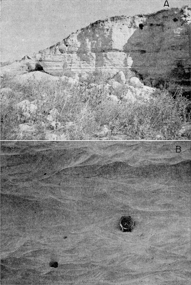
Scattered terrace remnants of Kansan and Yarmouthian age indicate that by Kansan time the major streams in Gove County had become entrenched in approximately the present geographic position. Small dissected terrace deposits of sand and gravel represent the Grand Island Formation, of Kansan age. The Grand Island is generally identified by its association with the overlying Pearlette Ash bed within the Sappa Formation of late Kansan and early Yarmouthian age (Fig. 6). Several Pearlette Ash deposits are present in Gove County; but the Sappa Formation where present generally consists of only a thin silty zone at the base of the ash. In most places, the underlying Grand Island was absent and only the Pearlette Ash bed was present. The Pearlette Ash, although of small areal extent in Gove County, is as much as 17 feet thick in the NE SW sec. 21, T. 13 S., R. 26 W. (Pl. 5).
Figure 6--Diagrammatic section showing stratigraphic relations of Pleistocene deposits in SE SW sec. 20, T. 15 S., R. 28 W.
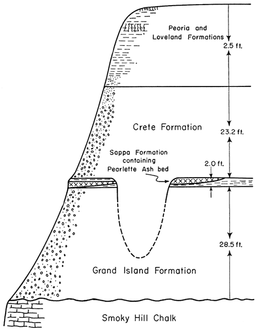
Plate 5--Volcanic ash deposit in Gove County. A, Pearlette Ash bed in NE SW sec. 21, T. 13 S., R. 26 W. B, Bedding detail of Pearlette Ash, same locality.
The Crete Formation, of Illinoisan age, consists of deposits of sand and gravel as terraces along the principal streams. Lithologically, the Crete and the Grand Island are very similar in Gove County, both being composed chiefly of coarse arkosic sand and gravel. Stratigraphically, the Crete Formation overlies the Sappa Formation and the Grand Island Formation in Gove County, although locally the Crete is channeled into the Grand Island (Fig. 6). Characteristically, much of the Crete Formation is of relatively wide areal extent; small thin deposits of arkosic sand and gravel are scattered over much of the southern half of Gove County. Where these deposits are not associated with the Pearlette Ash they are shown as the Crete Formation on Plate 1. Because they are relatively thin and laterally extensive, they have the appearance in many places of being pediment-type deposits. Thicker channel deposits are found along the principal streams, and are most extensive and thickest along Smoky Hill River.
Sand, gravel, and silt constitute the alluvial fill within the inner valleys of the principal streams in the county. The alluvium is believed to be of late Wisconsinan and Recent age. Along Smoky Hill River, low terraces of late Wisconsinan age border the narrow floodplain. Lithologically, the alluvial deposits underlying the flood plain are indistinguishable from the slightly older alluvial deposits underlying the low terraces, which were deposited before the Recent cycle of down cutting and alluviation began.
Fine silt and sandy silt, mostly eolian, mantles much of Gove County, particularly the upland in the northern part of the county, and is classified as the Loveland Formation of late Illinoisan age and the Peoria Formation of early Wisconsinan age. A few feet of silt representing the Bignell Formation of late Wisconsinan and Recent age was recognized locally in the northwestern part of Gove County. Where the Bignell was present it did not exceed 2 feet in thickness, and much of it was incorporated within the modern soil profile. Because it was not possible to map the eolian silt formations separately at the scale at which the geology of Gove County was mapped, and because the formations are lithologically and hydrologically similar, the eolian silts are shown together on Plate 1 as the Peoria and Loveland Formations (undifferentiated).
Prev Page--Geography || Next Page--Ground-water Principles, Recharge, Discharge
Kansas Geological Survey, Geology
Placed on web Sept. 30, 2008; originally published June 1960.
Comments to webadmin@kgs.ku.edu
The URL for this page is http://www.kgs.ku.edu/General/Geology/Gove/04_rock.html