![]()
Prev Page--Contents || Next Page--Geography
Introduction
Purpose and Scope of Investigation
This report gives the results of a study of the geology and ground-water resources of Gove County, Kansas. The study was designed to determine the availability and quantity of ground water in the county, to learn the geologic factors that control the occurrence of ground water, to determine the chemical characteristics of ground water in relation to geologic formations, and to serve as a guide to future ground-water development.
An investigation of the geology and ground-water resources of Gove County was begun by Willis D. Waterman, Geologist, U. S. Geological Survey, in the summer of 1952 and was continued during the spring of 1953. Owing to the resignation of Mr. Waterman, the project was reassigned in the summer of 1956 to the authors, who spent 2 1/2 months during the summer and fall of 1956 and 2 weeks during the fall of 1957 in the field gathering most of the data upon which this report is based.
Nearly all water supplies in Gove County are obtained from wells. Irrigation has been practiced in the larger valleys for several years, but drought in recent years has increased the interest in irrigation. Interest has also turned to the upland areas, and in the fall of 1956 seven irrigation wells were obtaining ground water from the Ogallala Formation in the northern part of the county. Most of the irrigation wells in the county have been drilled since 1950, and an additional increase in the use of ground water for irrigation can be expected. At the present rate of withdrawal, the danger of seriously depleting the ground-water supply seems slight, but there is a definite need for adequate understanding of the quantity and quality of water available from sources now being used, of possible additional sources, and of measures that may be necessary to safeguard their continuance.
This study was made as a part of the cooperative ground-water program begun in 1937 by the State Geological Survey of Kansas and the United States Geological Survey, in cooperation with the Division of Sanitation of the Kansas State Board of Health and the Division of Water Resources of the Kansas State Board of Agriculture.
Location and Extent of Area
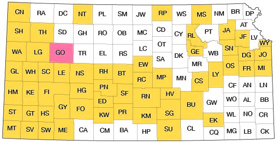
Gove County is in the third tier of counties south of the Nebraska border and the third county east of the Colorado border. It contains 30 townships, from T. 11 S. to T. 15 S. and from R. 26 W. to R. 31 W.; it extends approximately 36 miles east and west and 30 miles north and south. Gove County and other areas in which cooperative ground-water investigations have been made are shown in Figure 1.
Figure 1--Index map of Kansas showing area described in this report and areas covered by other online geologic reports, as of Sept. 2008. For additional information, please visit the KGS Geologic Maps of Kansas Page.
Previous Investigations
No detailed studies of the areal geology and ground-water resources of Gove County have been published, but specific reference to the county has been made in several earlier geological and hydrological reports.
Haworth (1897, 1897a) described the physiography of western Kansas and discussed the physical properties of the Tertiary rocks. Logan (1897) in a report on the Upper Cretaceous of Kansas discussed the occurrence of rocks of that age in Gove County. Williston (1897) described the Niobrara Chalk in western Kansas and discussed the Pleistocene deposits of Kansas (1897a). In his report on the utilization of the High Plains, Johnson (1901, 1902) referred to the source, availability, and use of ground water in western Kansas. In 1905 Darton reported on the geology and ground-water resources of the central Great Plains. A report by Parker (1911, p. 96) on the quality of water supplies in Kansas contained a brief description of the geologic setting of Gove County and analyses of samples of ground water. In a special report on well waters in Kansas, Haworth (1913) discussed the Tertiary of western Kansas and its water-bearing characteristics. Russell (1929) studied the stratigraphy and structure of the Smoky Hill Chalk in Logan, Gove, and Trego counties and reported on the usefulness of bentonite layers in interpreting the stratigraphy. The work of Elias (1931) was an important contribution to the geology of western Kansas, and his studies of the Ogallala Formation and late Pleistocene deposits were the foundation for later studies. Landes and Keroher (1939) briefly described the geology and petroleum resources of Logan, Gove, and Trego counties. Frye and Smith (1942) discussed graded valley slopes peculiar to the Smoky Hill River valley in Logan and Gove counties. A study of the Pleistocene geology of Kansas was made by Frye and Leonard (1952). Bradley and Johnson (1957) made a study of the ground-water resources of the Ladder Creek area in Kansas, including the southwestern corner of Gove County. Areas in Kansas for which reports of geology and ground-water studies have been published or are in preparation are shown in Figure 1.
Methods of Investigation
During the summer of 1952, 25 test holes were drilled through the Pleistocene and Tertiary deposits to Cretaceous bedrock by a hydraulic-rotary drilling machine owned by the State Geological Survey of Kansas. During the summer and fall of 1952 and the summer of 1953, the depth to water and the depth of the well were measured in 80 wells by steel tape from a fixed measuring point near the land surface, and 15 samples of water were collected from representative wells in the county and were analyzed by Howard Stoltenberg, chemist, in the Sanitary Engineering Laboratory of the Kansas State Board of Health. Altitudes of the wells and test holes were determined by plane table and alidade.
During the summer and fall of 1956 the authors inventoried additional wells and collected additional water samples. Well drillers were visited and logs of test holes and wells were collected. During this time the areal geology was mapped from field observations and from stereoscopic study of aerial photographs obtained from the U. S. Department of Agriculture. County maps prepared by the State Highway Commission of Kansas at a scale of 1 inch to the mile were used to record field data. In September 1957, 17 additional test holes were drilled in the county by the State Geological Survey.
Well-numbering System
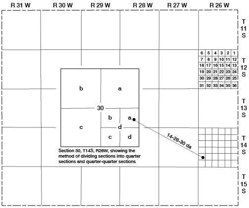
The location of wells, test holes, and local features in this report are designated according to General Land Office surveys in the following sequence: township, range, section, quarter section or 160-acre tract, and quarter-quarter section or 40-acre tract. The 160-acre and 40-acre tracts are designated a, b, c, or d in a counter-clockwise direction beginning in the northeast quarter. For example, well 14-26-30da is in the NE SE sec. 30, T. 14 S., R. 26 W. (Fig. 2). If two or more wells are within a 40-acre tract the location number is followed by serial numbers in the order in which the wells were inventoried.
Figure 2--Diagram illustrating well-numbering system used in this report.
Acknowledgments
Appreciation is expressed to the residents and municipal officials of Gove County who supplied information and gave assistance during the course of the field work. Wilbur White, County Agent of Gove County, and Howard Chaney of the Soil Conservation Service of the U. S. Department of Agriculture gave valuable aid in the collection of ground-water data. Thanks are given to Page Campbell, Robert Dickman, and Melvin Denlinger who permitted use of their wells for aquifer tests and to the Struckhoff brothers, drillers at Grinnell, Harry Coberly and James Tuttle, drillers at Gove, and Vern Litton, driller at Scott City, who provided logs of wells and test holes and other information on wells in the county.
The manuscript of this report has been reviewed critically by several members of the Federal and State Geological Surveys; by Robert V. Smrha, Chief Engineer, and George S. Knapp, Engineer, of the Division of Water Resources of the Kansas State Board of Agriculture; by Dwight F. Metzler, Chief Engineer, and Willard O. Hilton, Geologist, of the Division of Sanitation of the Kansas State Board of Health; and by Robert L. Smith, Executive Secretary, of the Kansas Water Resources Board.
Prev Page--Contents || Next Page--Geography
Kansas Geological Survey, Geology
Placed on web Sept. 30, 2008; originally published June 1960.
Comments to webadmin@kgs.ku.edu
The URL for this page is http://www.kgs.ku.edu/General/Geology/Gove/02_intro.html