[Originally published in 1987 as Kansas Geological Survey Guidebook Series 5. This is, in general, the original text as published. The information has not been updated. This publication is also available as an Acrobat PDF file (8 MB).]
The Midwest Friends of the Pleistocene meeting has been held in Kansas only once before, 1976--Meade County (Kansas Geological Survey, Guidebook Series 1). Focus of the 1986 field conference is not upon upland faunal sequences of south-central Kansas, but rather on the glacial terminus area and late Pleistocene-Holocene alluvial fills of northeastern Kansas. The glacial-limit problem has not been seriously addressed in recent years, and alluvial stratigraphy has only begun to receive attention.
Part two, Contributed Papers, has a dual purpose: 1) to provide background information for the stops during the field conference, and 2) to present a collective statement of what is currently known of Kansas prehistory. The former is necessary to place the conference stops in a regional context. The majority of stop descriptions are brief statements, primarily because the localities have only recently been discovered or exposed to their present extent. In-depth staff and student research is underway at most localities and will come to fruit in the near future. Observations and interpretations offered by participants will thereby prove invaluable. Early work in Kansas, such as that by Frye, Leonard and Hibbard up through the 1950's, is being expanded upon and, in many instances, revised. The Dort and Jones volume Pleistocene and Recent environments of the central Great Plains, published in 1970 (University Press of Kansas), provided a summary of regional data to that point. We have, however, extended well beyond the 1970 statement and consequently perceive this volume, although not as comprehensive, as an update of the former. The data base is rapidly expanding, largely due to an increasingly interdisciplinary approach. Individuals involved are from several units of the University community: Departments of Geography, Geology, Botany, and Anthropology; the Museums of Natural History and Anthropology, and the Kansas Geological Survey.
The leaders of this field conference are indebted to the large number of colleagues and graduate students that assisted in the preparations for the meeting. Further, Sharon Geil (Geology) presents her graduate research results at Stop 14 and Professors Larry Martin (University of Kansas Museum of Natural History) and Richard Rogers (University of Nebraska) assist with Stop 15B. Field work and conferences such as this can not, of course, be conducted without the cooperation of landowners and, in many instances, local informants. It is therefore appropriate that the following be acknowledged for providing access to sites described herein: Mr. S. Smith (N. R. Hamm Quarries), Mr. W. Doyle (Menoken Quarry), Mrs. S. Mitchell (Silver Lake), Mr. T. Clevenger (Bank 4, Topeka), Mr. E. Dalaba (De Soto), the staff of Builder's Sand Plant No. 2, and Mr. R. Elder (City of Wamego Water Department). Further, our knowledge of and access to the Topeka glacial terminal area has been greatly enhanced by Mr. W. Boltz (Topeka). Financial support from the University of Kansas Office of Research Support facilitated the preparation of site exposures. Finally, the volume in its refined form would not have been possible without the dedication of Marla Adkins-Heljeson, editor, and Jennifer Sims, illustrator, both with the Kansas Geological Survey.
William C. Johnson, Department of Geology, University of Kansas, Lawrence, Kansas, February 1987
| Year | Leaders | Location | |
|---|---|---|---|
| 1 | 1950 | eastern Wisconsin | S. Judson |
| 2 | 1951 | southeastern Minnesota | H. E. Wright and R. V. Ruhe |
| 3 | 1952 | western Illinois and eastern Iowa | P. R. Shaffer and H. W. Scholtes |
| u | 1952 | southwestern Ohio | R. P. Goldthwait |
| u | 1953 | northeastern Wisconsin | F. T. Thwaites |
| u | 1954 | central Minnesota | A. E. Wright and A. F. Schneider |
| 6 | 1955 | southwestern Iowa | R. V. Ruhe |
| u | 1956 | northwestern lower Michigan | J. H. Zumberge eta!. |
| 8 | 1957 | south-central Indiana | W. D. Thornburg and W. J. Wayne |
| 9 | 1958 | eastern North Dakota | W. Laird et al. |
| 10 | 1959 | western Wisconsin | R. F. Black |
| 11 | 1960 | eastern South Dakota | A. F. Agnew eta!. |
| 12 | 1961 | eastern Alberta | C. Gravenor et al. |
| 13 | 1962 | western Ohio | R. P. Goldthwait |
| 14 | 1963 | western Illinois | J. C. Frye and H. B. Willman |
| 15 | 1964 | eastern Minnesota | H. E. Wright and E. J. Cushing |
| 16 | 1965 | northeastern Iowa | R. V. Ruhe et al. |
| 17 | 1966 | eastern Nebraska | E. C. Reed et al. |
| 18 | 1967 | south-central North Dakota | L. Clayton and T. F. Freers |
| 19 | 1969 | Cyprus Hills, Saskatchewan and Alberta | W. Kupsch |
| 20 | 1971 | Kansas-Missouri border | C. K. Bayne et al. |
| 21 | 1972 | east-central Illinois | W. H. Johnson eta!. |
| 22 | 1973 | Lake Michigan basin | E. B. Evenson et al. |
| 23 | 1975 | western Missouri | W. H. Allen et al. |
| 24 | 1976 | Meade County, Kansas | C. K. Bayne et al. |
| 25 | 1978 | southwestern Indiana | R. V. Ruhe and C. G. Olsen |
| 26 | 1979 | central Illinois | L. R. Follmer et al. |
| 27 | 1980 | Yarmouth, Iowa | G. R. Hallberg et al. |
| 30* | 1981 | northeastern lower Michigan | W. A. Burgis and D. F. Eschman |
| 29 | 1982 | Driftless area, Wisconsin | J. C. Knox eta!. |
| 30 | 1983 | Wabash Valley, Indiana | N. K. Bleuer et al. |
| 31 | 1984 | western Wisconsin | R. W. Baker |
| 32 | 1985 | north-central Illinois | R. C. Berg et al. |
| 33 | 1986 | northeastern Kansas | W. C. Johnson et al. |
| u--unnumbered *--misnumbered |
|||
Field-trip map--Day 1, stops 1-13; Day 2, stops 14-15
| miles | |
|---|---|
| 0.0 | Intersection of 6th and Iowa streets in Lawrence, Kansas, at Master's Inn, conference headquarters. Proceed east on 6th Street (US-40, -59). |
| 1.3 | Turn north across the Kansas River. |
| 3.2 | Junction of US-59 and US-40. Continue north and west on US-24, -59. (The Sunday trip will tum east here.) |
| 4.9 | Rise up low terrace scarp. (This will be discussed on Sunday.) |
| 5.8 | View ahead to right shows subdued alluvial fan profile. The highway is located on the Newman terrace, purportedly of late Pleistocene and Holocene age. Therefore, these minor fans must have formed in Holocene time. |
| 7.3 | Limestone quarry on right is in the Oread Limestone (Upper Pennsylvanian); fig. 1 presents the bedrock stratigraphy pertinent to the field-trip route. |
| 9.5 | Rise up scarp from Newman terrace to the Buck Creek terrace. |
| 9.7 | Straight ahead on gravel road. |
| 9.8 | Turn right (east) on gravel road to Buck Creek School. |
| 9.9 | STOP 1--Buck Creek School; NW SW sec. 27, T. 12 S., R. 19 E., Williamstown 7 1/2-min quadrangle. |
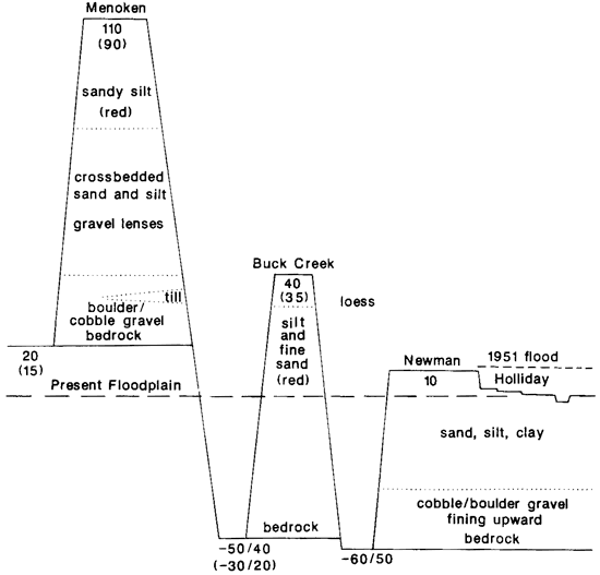
This first stop presents an excellent vantage point from which to consider an overview of the late Quaternary alluvial history of the lower Kansas River valley. The school site and directly north and east is the type locality for the Buck Creek terrace, named such by W. A. Carlson in 1951. Fig. 2 presents a schematic drawing of the terrace system for the lower Kansas River valley, as proposed in 1951. All four terraces and exposures of their fills will be visited during the course of the two-day field conference. For a detailed description of the terraces and associated soils types, see discussions by Dort and Sorenson et al., this volume. Also, Johnson and Martin, this volume, present an alluvial chronology of Holocene fills and place it in a regional context.
Figure 1--Stratigraphic column of bedrock cropping out along the route of the field trip (from Zeller, 1968).
Figure 2--Schematic representation of the erosional/depositional history of the Kansas River through Pleistocene and Holocene time as proposed by Carlson (1952) and Davis (1951) and followed by subsequent authors.
| miles | |
|---|---|
| 10.1 | Continue west on US-24, -59. |
| 11.5 | Limestone quarry to north, also in the Oread Limestone. |
| 11.9 | Continue west on US-24. |
| 13.1 | Continue on the Newman terrace surface. Less than a mile to the south is a low scarp separating the upper, smooth surface of the Newman terrace from the old channels and meander scars the Holliday terrace and floodplain. |
| 15.0 | Pass north of the town of Perry. |
| 15.5 | Cross Delaware River, impounded just to the north to form Lake Perry. |
| 17.0 | Perry Dam, built by the Corps of Engineers, is visible to the north. |
| 19.4 | Town of Newman to the south. This is the type locality for the Newman terrace, named jointly by S. N. Davis and W. A. Carlson in 1951. |
| 22.4 | Turn right (north) on gravel road. |
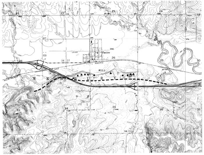
| 22.6 | STOP 2--Hamm quarry in the Deer Creek Limestone; NW SW sec. 15, T. 11 S., R. 17 E., Grantville 7 1/2-min quadrangle. |
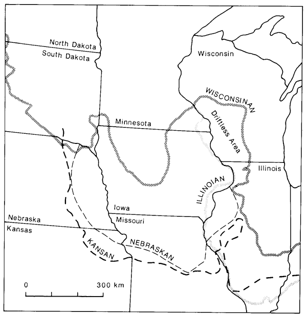
This quarry is situated beneath an overburden of "Menoken terrace" deposits. The stratigraphy here is complex, but an idealized section would include glacial outwash or alluvium overlain by pre-Illinoian glacial till. The Morrill soil series has commonly formed in the till. In several exposures, the till is overlain by loess and a red soil (Gymer series) has formed in loess of probable Loveland or older age. In some, if not most, instances these soils have been truncated and often are buried beneath younger loess or eolian sands in which the Sharpsburg or Shellabarger series are formed. Fig. 3 presents a regional representation of glacial limits for the four classical glaciations. See Dort, this volume, for a discussion of glaciation in Kansas.
Figure 3--Known or inferred termini of the four classical glaciations in central United States (modified from Flint, 1971). Note the position of Kansas at the southwestern limit of pre-Illinoian ice sheets.
| miles | Return to US-24. |
|---|---|
| 22.8 | Continue west on US-24. |
| 28.8 | Cross Soldier Creek. Channelization by the U.S. Army Corps of Engineers has caused severe bank erosion and channel entrenchment at the upstream end. |
| 29.7 | Meier's gravel pit on left (south). Excavation uncovered numerous logs and stumps. Samples of Platanus sp. (sycamore) and Quercus sp. (white-oak group) stumps collected by W. C. Johnson and P. Kopsick were radiocarbon dated at 1,670±55 (DIC-1760) and 2,620±70 yrs B.P. (DIC-1761), respectively. |
| 31.4 | Abandoned meander to right (north) was cut off prior to earliest mapping in this area. It may be as old as 200 yrs. |
| 33.4 | Turn right (north) on Menoken Road. |
| 33.9 | Again cross channelized reach of Soldier Creek. |
| 34.4 | Turn left (west) on NW 33rd Street, a gravel road. |
| 34.7 | Continue west on private road. |
| 34.9 | Turn right (north) into Menoken (Doyle) gravel pit. |
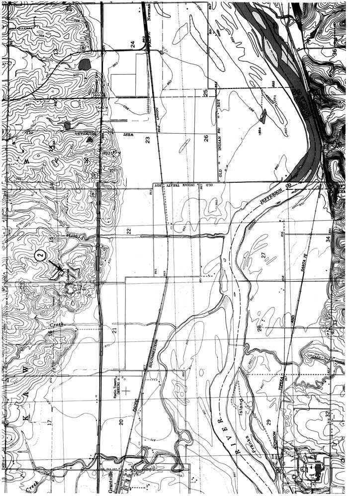
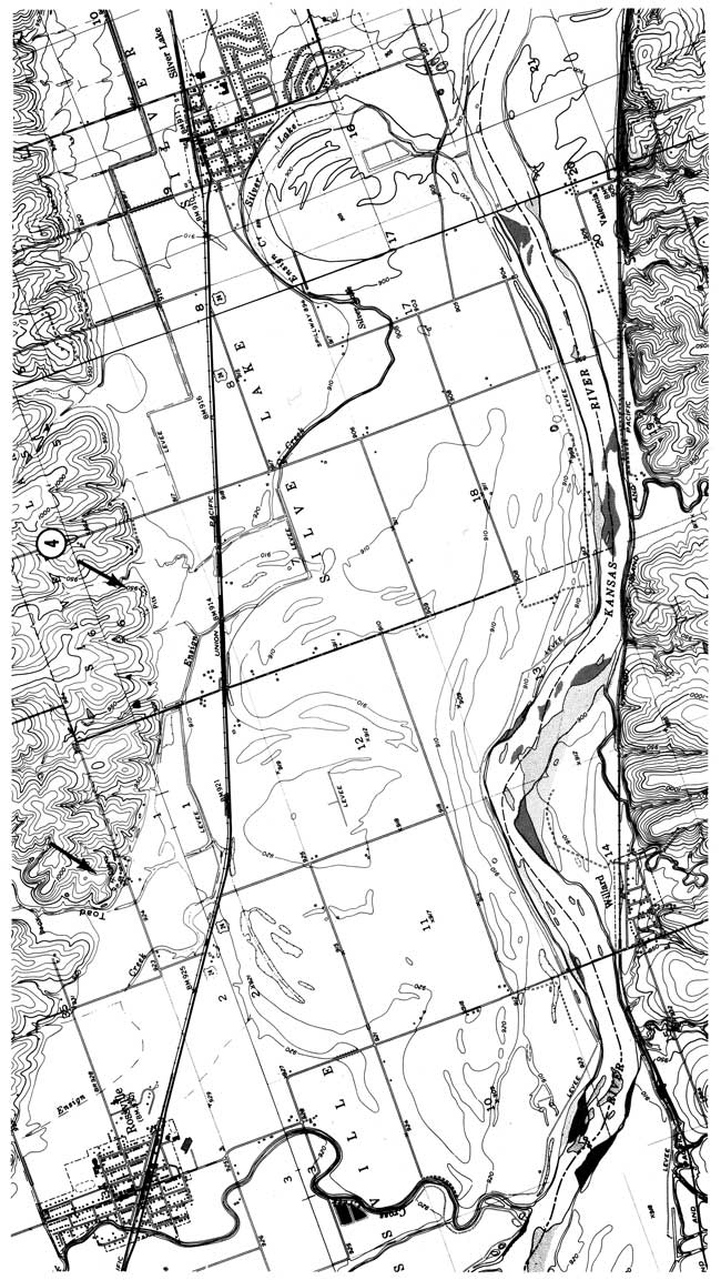
| 34.9 | STOP 3--Menoken (Doyle) gravel pit; NE SW sec. 9, T. 11 S., R. 15 E., Silver Lake 7 1/2-min quadrangle. |
This stop is the type locality for the "Menoken Terrace" complex that was named by S. N. Davis in 1951. The general stratigraphy here is similar to that at Stop 2. Major theses discussed at this stop include the possible glaciofluvial sources of the extensive gravel deposits here, the potential colluvial nature of the "loess," and sources of carbonates in some of the surface soils.
| miles | Return to US-24. |
|---|---|
| 36.3 | Continue west on US-24. |
| 42.5 | Silver Lake, the abandoned meander to left (west), was part of the channel of the Kansas River in 1873, but had been cut off by 1902. |
| 43.2 | Town of Silver Lake. |
| 44.9 | Turn right (north) on dirt road. |
| 45.4 | Turn left (west) on private drive. |
| 45.9 | STOP 4--Mitchell gravel pits; NW SE sec. 6, T. 11 S., R. 14 E., Willard 7 1/2-min quadrangle. |
The exposures at this stop are conspicuous by the near absence of till and the presence of a sharp, irregular buried surface separating "loess-colluvium" from underlying gravels. Irregularity of this surface seems to result from erosion. A well developed paleosol in the "loess-colluvium" is buried beneath sandy sediments. These sediments seem to be Holocene sands and are probably derived from floodplain deposits on the adjacent Newman surface.
| miles | Return to US-24. |
|---|---|
| 47.1 | Continue west on US-24. |
| 48.2 | The abandoned meander to left (south) was cut off prior to the earliest mapping in this area. It is probably 300 yrs old. The feature occupies a local embayment of the floodplain into the Newman terrace. |
| 49.1 | A gravel pit is visible on the valley side to the right (north). It exposes material similar to that seen at Stop 4. |
| 50.8 | Town of Rossville. |
| 56.7 | The highway traverses another small embayment of floodplain into the Newman terrace. |
| 58.5 | Town of St. Marys. |
| 58.7 | The terrace scarp down to left (south) is between the Newman surface, on which the highway is located, and the floodplain. Although the river is now almost 2 mi (3 km) to the south, in 1902 it was only 1,500 ft (450 m) from the highway. |
| 59.3 | An old gravel pit is just visible on the valley side to right (north). It exposes a thin section of silt over gravel, similar to that at Stop 4. |
| 61.3 | Terrace scarp down to left (south) is between the Newman surface and the floodplain. |
| 64.8 | Town of Belvue. |
| 67.9 | Cross the Vermillion River. Its confluence with the Kansas River is directly to the left (south). |
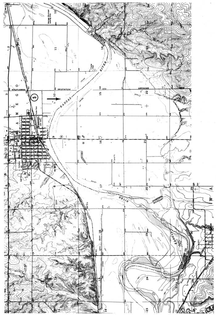
| 69.2 | Turn on Pottawatomie County road 72 to left, continue west. |
| 71.6 | Windmill Park. Note decorative use of Sioux quartzite erratics. |
| 71.8 | Town of Wamego. Turn left (south) onto Lincoln Avenue. |
| 71.9 | Turn left (east) on Valley Street. |
| 72.4 | Turn right (south) into Riverside Mobile Home Park. |
| 72.6 | STOP 5--River-bank exposure, SE SW sec. 10, T. 10 S., R. 10 E., Wamego 7 1/2-min quadrangle. The exposure is reached by walking approximately 900 ft (300 m) east (downstream). |
This stop provides an opportunity to view one of the best exposures of adjacent Newman and Holliday terraces and fills on the Kansas River. It also presents an example of the influence of ancient stream deposits on contemporary channel stability.
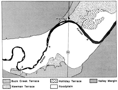
Alluvial Surfaces--Three alluvial terraces have been mapped within this reach of the valley (Beck, 1959; Fader, 1974; Bowman, 1985). They are, from oldest to youngest, Buck Creek, Newman, and Holliday terraces (fig. 4). Situated approximately 12 m (40 ft) above the floodplain, the Buck Creek terrace is well-represented through the reach on both sides of the valley. The river comes into contact with the Buck Creek fill, as mapped, at Wamego and upstream on the south side of the valley. This fill has been characterized as predominantly reddish-brown silt and clay, within which the Sangamon soil had developed (Dufford, 1958).
The Newman terrace, the most extensive terrace surface in the reach, is characteristically 3 m (10 ft) above the floodplain. Stratified silt, clay, and sand comprise Newman fill. Unaltered portions exhibit a distinct buff color. The Holliday terrace occupies an intermediate position between the Newman terrace and the lower, modern floodplain (McCrae, 1954). In contrast to the Buck Creek and Newman surfaces, the Holliday terrace exhibits numerous meander scars, point-bar scrolls, and other floodplain features. Underlying sediments are predominantly silts, gray in color. The floodplain, comprising most of the valley bottom in the reach, consists of sand fill with thin interstratified intervals of silt and clay (Bowman, 1985).
Stratigraphy--This stop otters an excellent view of Newman and Holliday fill stratigraphy and of the contact with one another. Stratigraphy is exposed for a distance of approximately 800 m (2,640 ft) east from Wamego.
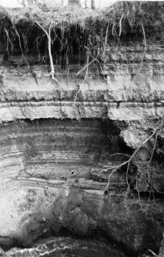
Figure 4--Map of alluvial surfaces adjacent to the Kansas River in the vicinity of Wamego. The exposed contact of Newman and Holliday fill is noted by the arrow (from Bowman, 1985). Radiocarbon-dated localities indicated at points 1 and 2.
Bowman (1985) notes three stratigraphically distinct units within the Newman fill exposed. An upper unit (Tn-1) consists of buff-colored silt and lacks any apparent sedimentary structures. Thickness of this unit decreases eastward from 7.25 m (23.9 ft) to less than 1 m (3.3 ft) at the contact with Holliday fill. Alternating silt and clay strata comprise the next unit down (Tn-2), which becomes progressively coarser to the east, but pinches out well before the terrace-fill contact. The lowermost unit (Tn-3), consisting of trough-crossbedded sand and gravel, climbs from the lower .5 m (1.7 ft) eastward to the fill contact where it comprises the entire Newman fill sequence exposed.
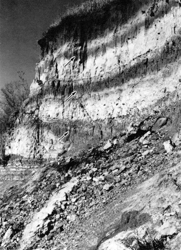
Three paleosols are obvious within the Newman fill (fig. 5). Humates from the basal and middle paleosols have been radiocarbon dated to 7,250±110 (DIC-2946) and 4,950±120 yrs B.P. (DIC-3355), respectively. The paleosol extends for the entire length of the fill exposure and was dated 200 m (660 ft) upstream (fig. 4.1) of the contact with Holliday fill. This early Holocene age is consistent with radiocarbon dates obtained at the Bonner Springs exposure of Newman fill (Stop 15). A third radiocarbon assay was obtained on humates from a paleosol exposed in the first cutbank upstream (fig. 4.2). The date of 8,310±120 yrs B.P. (DIC-3208) is Newman in age but occurs within fill below a surface mapped as the pre-Wisconsinan Buck Creek. Simple field observation indicates this is a case of mismapping or cartographic error.
Because of its near-horizontal orientation, the lowermost paleosol cuts through each of the stratigraphic units noted above and is thereby a time-stratigraphic marker (Bowman, 1985, p. 124). This fining-upward sequence, with its basal trough-crossbedded sand and structureless silt cap, probably represents vertical accretion beginning with point-bar deposition. At least three periods of relative floodplain stability occurred, however, permitting soil development.
Holliday fill presents a color and stratigraphic contrast with the adjacent Newman fill. The terrace fill, gray-brown in color, contains more silt and less clay than that of the adjacent Newman terrace. One paleosol is evident at the exposure but has not been radiocarbon dated due to humate contamination from abundant contemporary rootlets and the lack of charcoal or wood. Late Holocene radiocarbon dates have, however, been obtained on Holliday fill at the Bonner Springs exposure.
Figure 5--Three paleosols (arrows) evident in the upstream end of the cutbank exposure of Newman fill. A radiocarbon date of 7,250±110 yrs B.P. (DIC-2946) has been obtained on the lowermost of the three paleosols, and 4,950±120 yrs B.P. (DIC-3355) on the middle one. A paleosol exposed in the adjacent upstream bend has been dated at 8.310±120 yrs B.P. (DIC-3208). All assays are from humates extracted from the upper 15 cm of the paleosols (photo by W. C. Johnson).
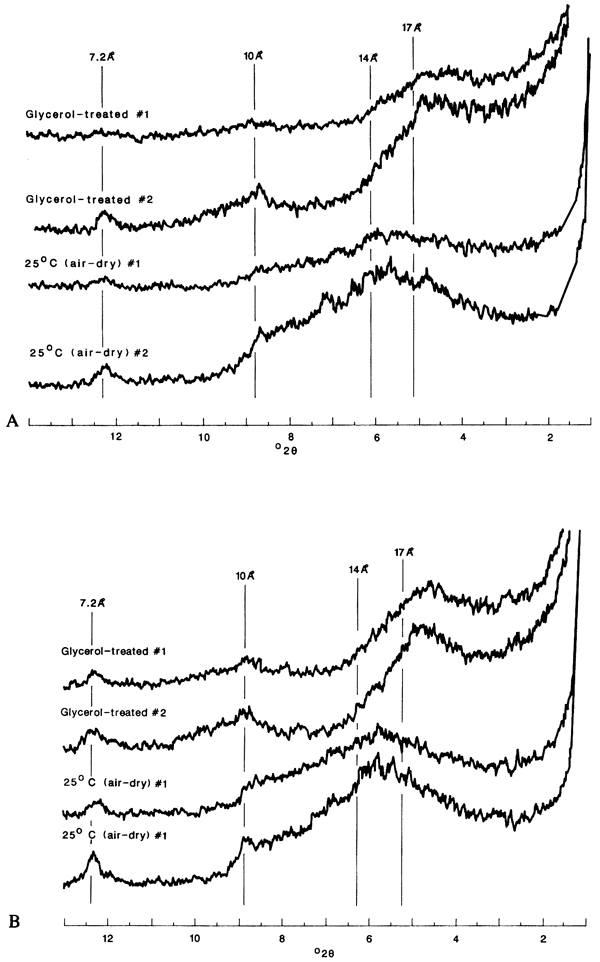
Although age, color, texture, and other stratigraphic differences exist between Newman and Holliday fills, x-ray diffraction data indicate the two have similar clay mineralogies. X-ray diffraction patterns of the whole-clay fraction from samples of both fills (fig. 6) indicate the clays are dominated by mixed-layer minerals containing notable concentrations of smectites. Kaolinite and illite are either extremely weathered or exist in very small concentrations. This mineralogy does contrast with the Newman and Holliday fills at the Bonner Springs exposure (see discussion Stop 15B).
Figure 6--X-ray diffraction patterns of the whole clay fraction (<2u) from the Wamego riverbank exposure. Clays are dominated by mixed-layer minerals that appear to contain significant concentrations of smectites, as supported by the expansion of the interlayer spacing to 17-18 Ä (Newman fill) and 14-15 Ä (Holliday fill) upon glycerol treatment. This is characteristic of the more pure forms of montmorillonite. Kaolinite and illite are extremely weathered or exist in extremely small concentrations. A, Holliday fill; B, Newman fill.
Lateral-channel stability--The valley reach in the vicinity of this stop provides an instructive example of control exerted by old alluvial fills on the degree of lateral-channel activity (Bowman, 1985). The upstream meander has been active historically, whereas the bend along which the Buck Creek, Newman, and Holliday fills are encountered has been relatively inactive (fig. 7). The active reach has undergone rapid meander growth since 1919, resulting in an anticipated cut-off of 156 hectares (390 acres) of agricultural land. Since about 1885, the bend near Wamego has maintained approximately the same position.
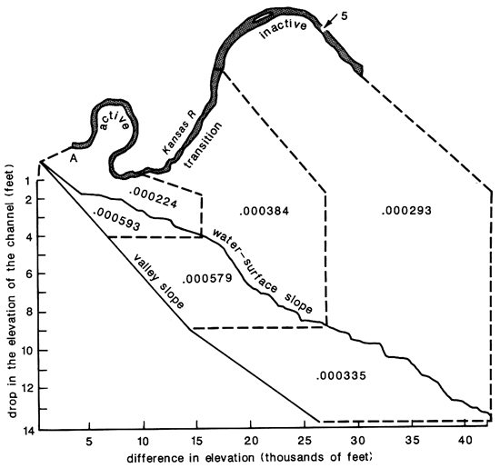
The active-channel meander has formed within the modern-floodplain alluvium, which is sandy and generally noncohesive. Fine, cohesive bank material encountered in the old alluvial fills of the stable meander are cohesive and therefore more resistant to erosion. The cohesive material permits the banks to withstand stream power induced by a channel slope (water-surface) that is somewhat greater than within the active reach (fig. 8). Further, the relatively steep valley slope has certainly contributed to the lateral activity of the upstream reach. Presumably the channel meandered until only sufficient slope remained to permit transport of sediment supplied to the channel.
Channel instability may be induced by the presence of valley fills that are out of equilibrium with the regimen of the contemporary channel (e.g., Grissenger and Murphy, 1983). In this situation, the deposits from precursors of the contemporary channel seem to be resulting in channel migration upstream.
Figure 7--The disparity in lateral migration between two adjacent reaches within the vicinity of Wamego: a) the subtle changes in channel position since 1885 for the inactive (stable) reach. b) a sequence of four maps illustrating the large amount of lateral migration documented in the active (unstable) reach from 1885 to 1978 (from Dort, 1980).
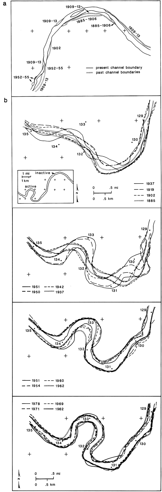
Figure 8--Relationship between water surface and valley slope for laterally active, inactive, and intermediate reaches of the Kansas River above and in the vicinity of Wamego. Water-surface slope is presented as the drop in elevation divided by the length of channel (from Bowman, 1985).
| miles | Return to Lincoln Avenue (K-99). |
|---|---|
| 74.0 | Low terrace scarp to the right (west). This may be between the floodplain and one of the surfaces of the Holliday terrace complex. |
| 76.3 | Climb steep terrace scarp that separates the Buck Creek terrace above from a Newman or Holliday surface below. |
| 77.6 | Hill with limestone boulders to left (east). |
| 78.5 | Hill with limestone boulders to left (east). |
| 78.8 | This hill is veneered with quartzite boulders. |
| 79.6 | Turn left (east) on gravel road. Note limestone and shale bedrock. |
| 80.3 | Boulders on slopes ahead are Sioux quartzite. |
| 80.9 | Quartzite boulders on slopes ahead. Bedrock quarry to right (south). Quartzite boulders to left (north). |
| 81.1 | Quartzite boulders to left (north). |
| 82.1 | Turn right (south) on gravel road. |
| 82.1 | STOP 6--Hilltop microwave tower; NE NE sec. 12, T. 11 S., R. 10 E., McFarland 7 1/2-min quadrangle. |
We are standing on an apparent terminal deposit left by a pre-Illinoian ice sheet. This locality and several others like it are striking because of the purity of the deposit which is composed of nearly 100% Sioux quartzite boulders. Concentration of these boulders on topographic highs has led to considerable speculation concerning the role of erosion in their distribution.
| miles | Continue south on gravel road. |
|---|---|
| 82.4 | Quartzite boulders to left and right. |
| 82.6 | Bedrock quarry to right (west). Outcrop to left (east). |
| 84.2 | Quartzite boulders to left (east). The creek to the right (west) is the approximate glacial boundary. |
| 84.9 | Quartzite boulders are restricted to the base of the slope to the right (west). |
| 85.6 | Turn right (west) on 1-70. |
| 86.1 | The valley to the left (south) was occupied by a pro-glacial lake. |
| 88.0 | Exit to K-99 north. |
| 88.2 | Turn right (north) on K-99. |
| 88.6 | Turn right (east) on gravel road. |
| 88.7 | STOP 7--Roadside gravel pit; NW NE sec. 27, T. 11 S., R. 10 E., Alma 7 1/2-min quadrangle. |
This locality is more than 2 mi outside of the supposed limit of glaciation as indicated by the distribution of Sioux quartzite erratics, yet the gravel exposed here includes a scattering of quartzite cobbles. One possible explanation is that this deposit was left by a glacier advance earlier than that which spread the boulders to the northeast. Alternatively, it may be somehow related to the spillway 1 mi (1.6 km) to the northwest which controlled the overflow of a large pro-glacial lake in the Kansas River valley.
| miles | Return to I-70. |
|---|---|
| 89.4 | Turn left (east) on I-70. |
| 92.3 | Erratics are present on the hills to the left (north), but not to the south. |
| 95.3 | Cross Mill Creek, the valley of which was occupied by a pro-glacial lake. The roadcut ahead coincides with the position of the glacier terminus. |
| 95.7 | Erratic boulders are present on the ridge to the left (north); none to the south (see topographic map on opposite page). |
| 95.8 | The gravel pit in the ridge to the left (north) exposes gravel underlying a till cap. |
| 99.7 | Crossing bed of small pro-glacial lake. Buffalo Mound ahead on left probably was unglaciated. The times of brush are controlled by outcrops of alternating limestone and shale. |
| 102.9 | Exit for rest stop. |
| 103.3 | REST STOP. |
| miles | Return to 1-70. |
|---|---|
| 103.6 | Continue east on 1-70. The glacial boundary crosses the highway and extends toward the southeast. |
| 105.5 | Numerous quartzite boulders are visible by the hilltop house to the right (south). |
| 108.4 | Leave I-70 at exit 346. |
| 108.6 | Turn right (south) on road to Dover. |
| 113.0 | Quartzite boulders are present on hills to the right and the left and ahead. |
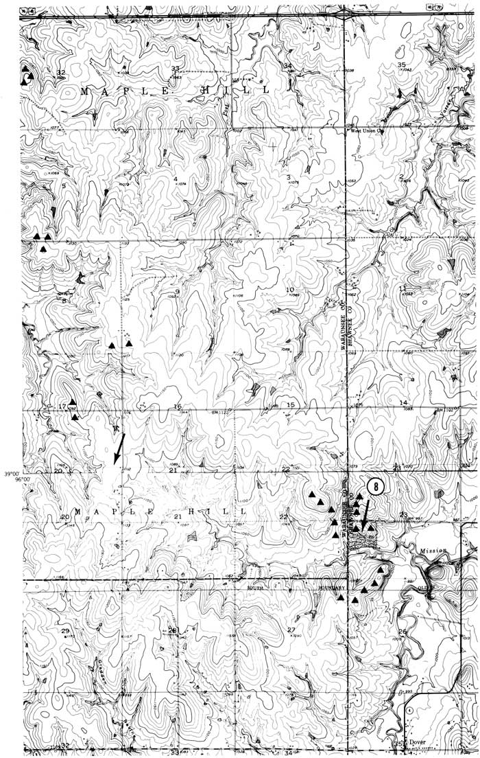
| 113.2 | STOP 8--Dover quarry; NW SW sec. 23, T. 12 S., R. 13 E., Dover 7 1/2-min quadrangle. |
Exposed here is a combination of a concentrated upland boulder field, similar to that of Stop 6, and loess-colluvial soils like those of stops 1, 2, 3, and 4.
| miles | Continue south. |
|---|---|
| 113.6 | Quartzite boulders are numerous on the ridge to the left (east); this is the glacier terminus. |
| 115.1 | Turn left (east) on K-4. |
| 115.6 | Town of Dover. Turn left (north) on K-4. |
| 117.3 | Quartzite boulders on hilltop. Continue on curvy K-4. Glacial boundary generally lies well north of the highway. |
| 123.9 | Quartzite boulders on hill to right (south). This is the approximate glacial boundary. |
| 125.4 | Stop sign. Turn right (south) onto Auburn Road. |
| 125.9 | Turn left (east) on 29th Street. |
| 127.1 | The development area nearby to the right (south) lies on till. The hills farther south are unglaciated. |
| 127.4 | Stop sign. |
| Continue east on 29th Street. | |
| 127.8 | STOP 9--Baseball field exposure; NW NE sec. 17, T. 12 S., R. 15 E., Silver Lake 7 1/2-min quadrangle. |
Exposed here is a cobble-boulder gravel composed largely of limestone clasts, but containing a modest percentage of northern erratics, mainly greenstone and varieties of granite, some of which are thoroughly weathered and disintegrated. At the top is an intensely oxidized till in which the erratics are almost all Sioux quartzite. It is suggested that these two units represent two separate advances of the ice sheet.
| miles | Continue east on 29th Street. |
|---|---|
| 128.9 | Stop sign. Continue east. |
| 129.4 | Traffic signal. Continue east. |
| 129.9 | Turn right (south) on Fairlawn Drive. |
| 130.0 | Turn left onto I-470. Just to the west at this turn, Ed Marling's store lies on the glacial terminus. Till is exposed east of the store. |
| 131.3 | Roadcut through ridge, which is capped by till and is colloquially known as "The Terminal." |
| 132.1 | Leave 1-470 at exit 5. |
| 132.4 | Turn left (north) on Burlingame Road. |
| 132.7 | Turn left (west) on 37th Street. |
| 133.1 | Turn left (south) on Wood Valley Drive; follow around to right. |
| 133.4 | Turn right (north) on Deer Trail Drive; follow around to left and uphill. |
| 133.6 | Top of hill. |
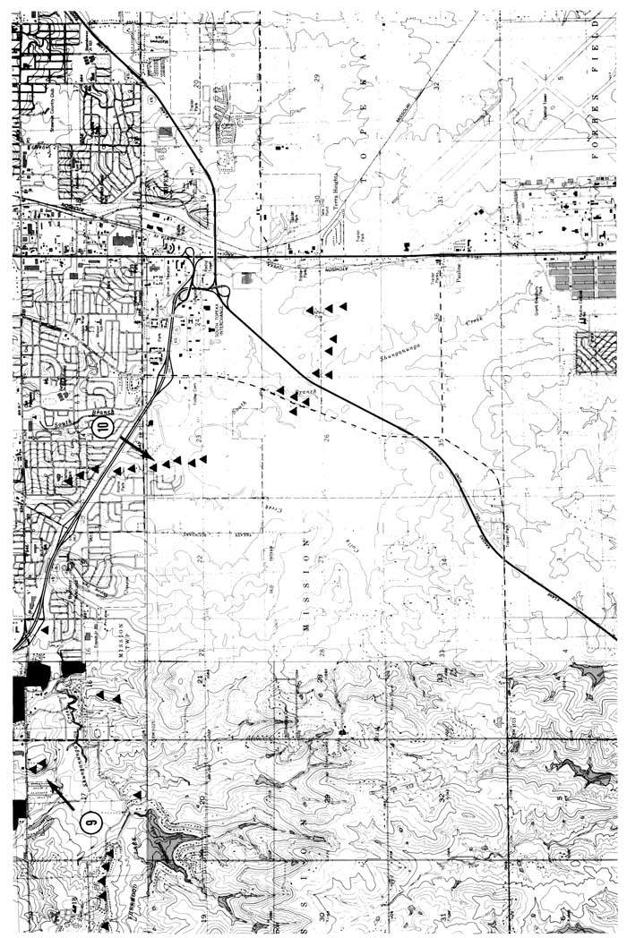
| 133.6 | STOP 10--Top of "The Terminal"; NENW sec. 23, T. 12 S., R. 15 E., Wakarusa 7 1/2-min quadrangle. |
This location is on the summit of what has been called colloquially the "Topeka Terminal." The ridge does mark the limit of ice advance, but it has a high bedrock core and so is not a true terminal moraine. An extensive network of deep excavations for sewers and water mains exposed thick, highly oxidized till, locally underlain by clean, well-sorted quartz sand. More than half of the boulder and cobble clasts are limestone; granitic types are moderately common, some intensely weathered; Sioux quartzite is relatively scarce. Although limonite "hollow stones" and masses of iron-oxide spongework are common, their significance has yet to be determined. The flat summit area seems to be a product of erosion (deflation?) to a resistant soil horizon.
| miles | Retrace route and turn left onto I-470 eastbound. |
|---|---|
| 134.1 | Leave 1-470 at exit 6 to US-75. |
| 134.5 | Turn south on US-75. |
| 135.2 | Turn left (east) on 45th Street. |
| 137.2 | Turn right (south) on California Avenue. |
| 138.1 | Forbes Field (airport) lies to the right. |
| 138.2 | Turn left (east) on 53rd Street. |
| 139.3 | Turn right (south) on Berryton Road. |
| 141.2 | Turn left (east) on 69th Street. |
| 142.3 | Turn right (south) on Croco Road (gravel). |
| 144.4 | Turn left (east) on 45th Street. Areas of red soil mark patches of glacial sediments. |
| 145.0 | STOP 11--Ice-wedge patches in roadcut; SW SE sec. 14, T. 13 S., R. 16 E., Richland 7 1/2-min quadrangle. |
It is believed that this shallow cut exposes two sedimentary units of glacial origin. The lower one is basically a quartz sand with admixed clay and sparse erratics; the upper one is a till containing cobbles and small boulders of Sioux quartzite. Both are highly oxidized. Visible downslope to the east is a well-cemented limestone-pebble gravel with less than 1% northern erratics. Absolute-age relationships of these units are unknown.
| miles | Continue east. |
|---|---|
| 145.4 | Turn right (south) on Paulen Road. |
| 146.0 | Turn left (east) on 89th Street. Old gravel pit on left has been leveled for houses. Wakarusa Valley on right. |
| 151.9 | Boulder-covered hill to right front. |
| 152.1 | Turn left (north). |
| 153.2 | Turn right (east). |
| 154.6 | Turn right (south) on Douglas County road 458. |
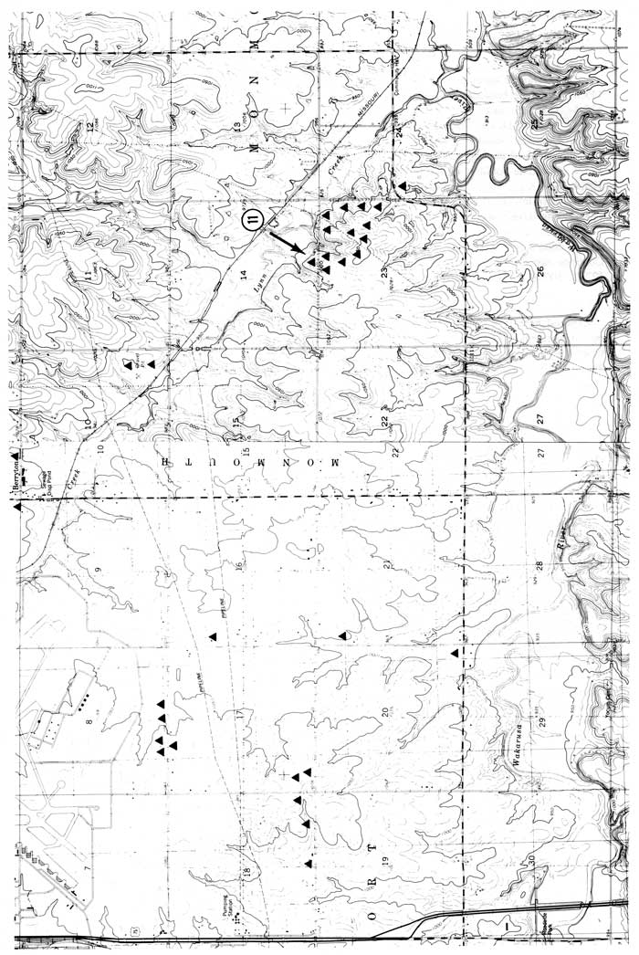
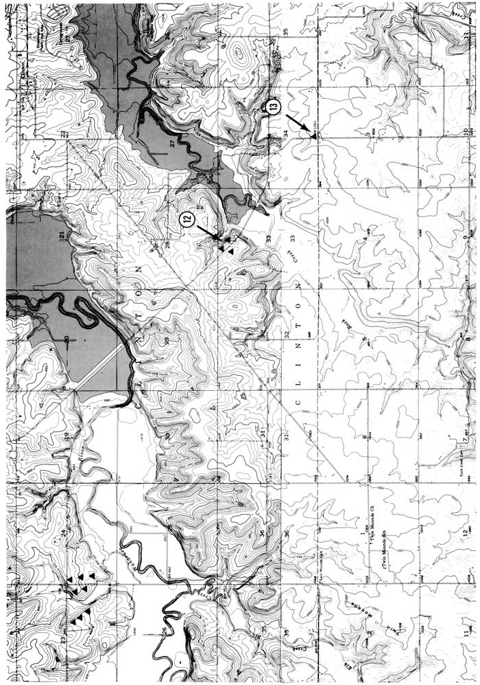
| 158.0 | STOP 12--Two-till roadcut; NE NW sec. 33, T. 13 S., R. 18 E., Clinton 7 1/2-min quadrangle. |
This long cut, situated very close to the glacial terminus, exposes till and glaciofluvial outwash above limestone bedrock. The presence of a paleosol between two units of glacial origin provides evidence of two advances of the ice sheet.
| miles | Continue east. |
|---|---|
| 159.2 | Turn right (south) on Douglas County road 1029. |
| 159.7 | STOP 13--Crestline till; SW SW SE sec. 34, T. 13 S., R. 18 E., Clinton 7 1/2-min quadrangle. |
Exposure of till, including Sioux quartzite erratics, at this road intersection proves that the ice front temporarily reached the crest of this divide.
| miles | Return to Douglas County road 458. Continue east. |
|---|---|
| 170.5 | Turn left (north) on US-59 (Iowa Street). |
| 175.2 | Intersection of 6th and Iowa streets (return to meeting headquarters). |
| miles | |
|---|---|
| 0.0 | Leave intersection of 6th and Iowa streets. Go east on 6th. |
| 1.4 | Turn north across Kansas River on US-40, -59. |
| 3.3 | Turn east on K-24. |
| 3.4 | The high-water level of the 1951 flood is marked on the concrete Tee Pee building to the right. |
| 3.6 | Rise from the floodplain/Holliday terrace complex onto the Newman terrace. |
| 3.9 | Cross the western end of an abandoned meander that cut into the edge of the Newman terrace. This channel was abandoned prior to the earliest mapping and may be 200-300 yrs old. |
| 5.1 | Cross the eastern end of the same abandoned meander. |
| 5.6 | Cross Mud Creek; it was channelized by the U.S. Army Corps of Engineers. |
| 5.7 | Tum east on K-32. |
| 14.0 | Town of Linwood. |
| 14.6 | Cross Stranger Creek. |
| 15.4 | Turn right on Leavenworth County road 26. |
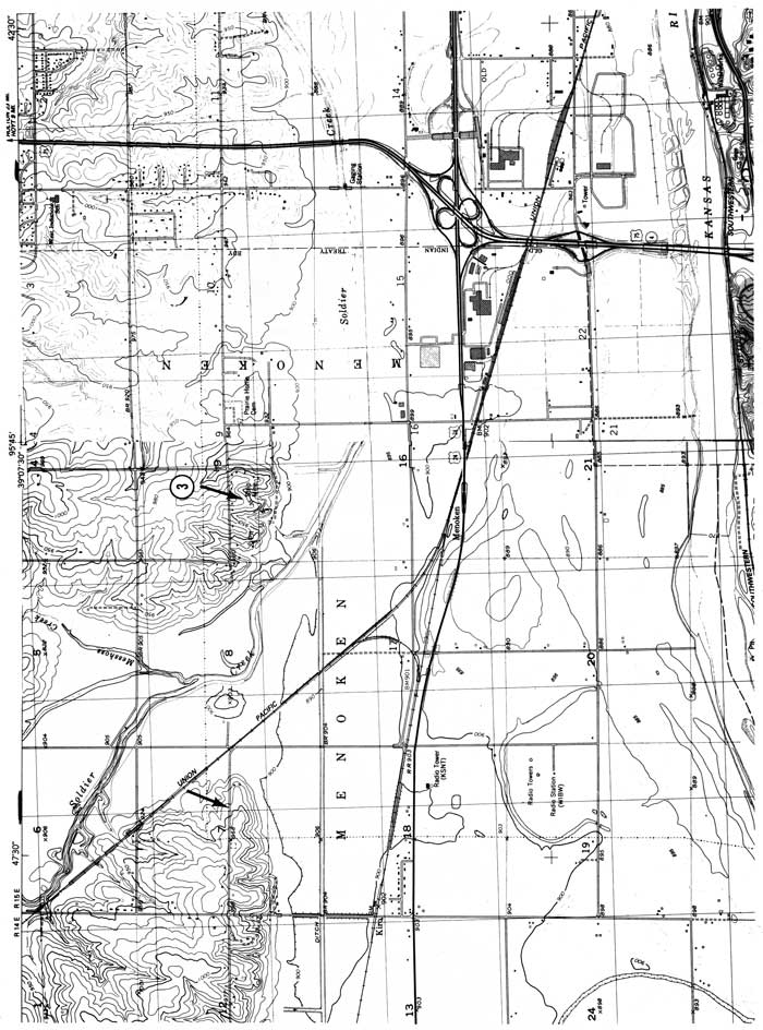
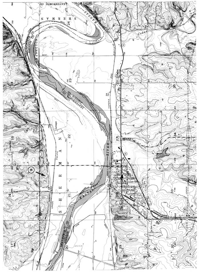
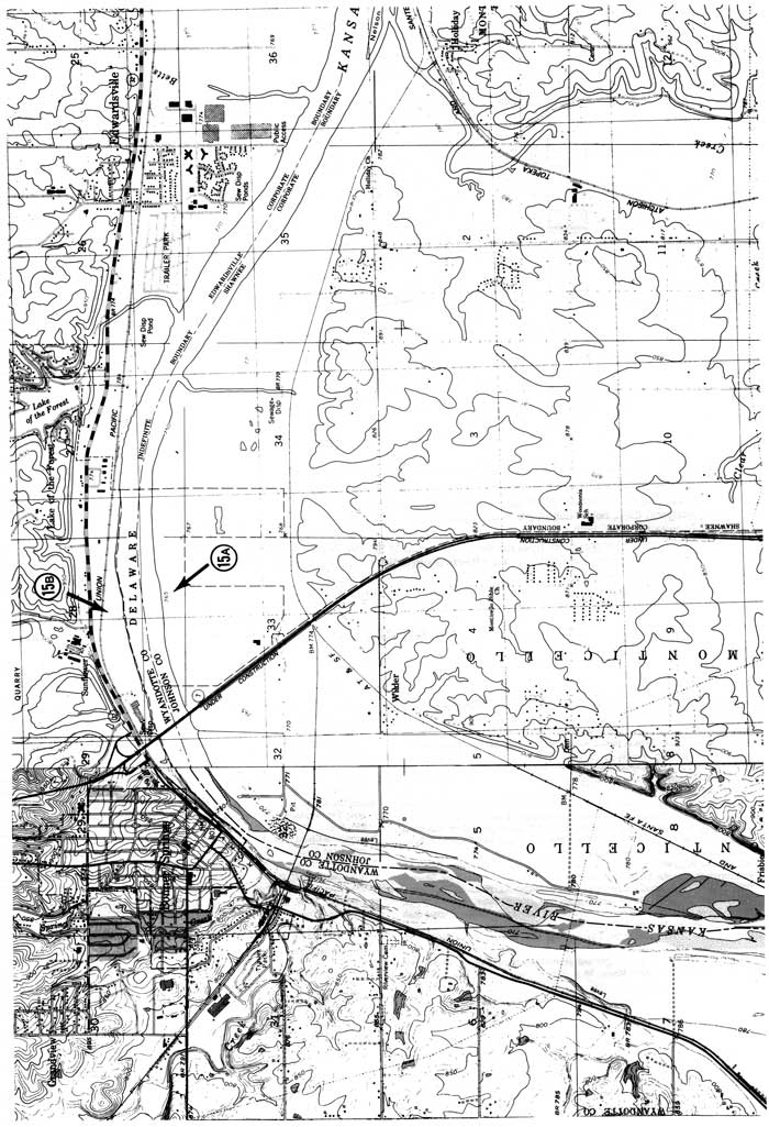
| 18.7 | STOP 14--Volcanic-ash exposure; NE NE sec. 21, T. 12 S., R. 22 E., DeSoto 7 1/2-min quadrangle. |
The terraces along the lower Kansas River were mentioned in various reports during the mid-1930's and 40's, but were not named until the early 1950's (Davis, 1951; Carlson, 1952). At that time it was thought that one terrace had been formed during each of the last three of the four periods of continental glaciation of classical Pleistocene terminology. Davis and Carlson (1952) made detailed studies of those terraces between Lawrence and Topeka, Kansas. They stated that the Kansas River, as it exists today, formed during the Kansan glaciation as an ice-margin stream, though a precursor stream existed during the Nebraskan glaciation. The valley of the Kansas River was filled with up to 80 ft (24 m) of glacial outwash, forming the Menoken terrace surface. During the Illinoian glaciation, the valley was incised 50-60 ft (15-18 m) and then aggraded to 35 ft (11 m) above the modern floodplain level. The resulting surface, preserved only at the mouths of tributary streams, is known as the Buck Creek terrace. A cut-fill cycle which occurred during the Wisconsinan glaciation formed the Newman terrace. This terrace is still being aggraded by exceptionally severe floods (Holien, 1982). A fourth possible terrace, the Holliday terrace complex, was defined by McCrea (1954) and named by Dufford (1958). It is a complex of several small, scarped surfaces which Davis and Carlson (1952) included as irregularities on the modern floodplain surface.
Terraces are difficult geomorphic features to date since they technically consist of only a two-dimensional surface. The sediments within the underlying fill can usually only be assigned a relative age by using cross-cutting relationships. For example, the Buck Creek fill truncates Kansan glacial deposits and is capped by either a well-developed (Sangamon?) soil or discontinuous Peorian loess (Davis and Carlson, 1952). Thus it is assumed to be of Illinoian age.
The Buck Creek terrace generally is about 11 m (36 ft) above the floodplain. The Menoken terrace is usually 24-30 m (79-99 ft) above the floodplain, while the Newman terrace was covered during the 1951 flood. This suggests that the terrace at this locality is a remnant of the Buck Creek terrace. The upper surface is currently about 6 m (20 ft) above the level reached by the Kansas River during the 1951 flood, even though the field above this exposure has been bulldozed by the owners.
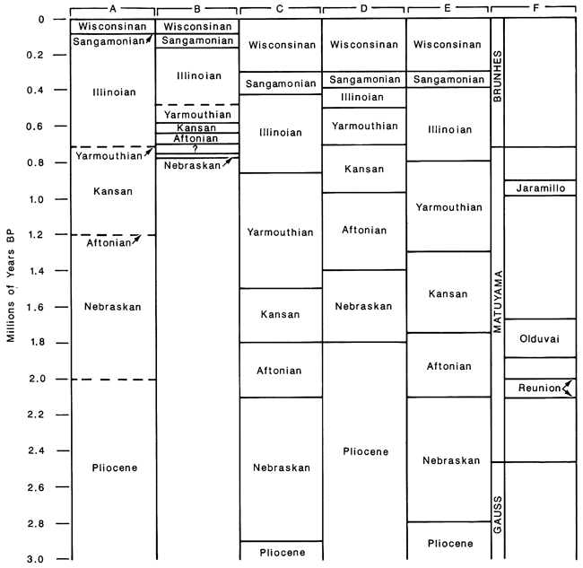
Figure 9--Comparison of recently published chronologies for the Pleistocene. A) Boellstorf, 1976. Continental record, after Reed and Dreeszen (1965), based on reconciling data from Nebraska. B) Dubé, 1985. Tentative Midcontinent record, based on best dates of type localities. C) Dubé, 1985. Marine conceptual Midcontinent, based on correlation of paleotemperatures, eustatic cycles, and oxygen isotope stages in the Gulf of Mexico. D) van Eysinga, 1978. Accepted as standard by the Geological Society of America. E) Smith, 1985. Marine record, after Beard (1982), based on all available data from the Gulf of Mexico and Vrica, Italy. F) Magnetic polarity, Mankinen and Dalrymple (1979).
The fill beneath this particular terrace remnant contains a volcanic ash for which an absolute date can be determined. Only two families of ash have been recorded within the eastern portions of Kansas and Nebraska (Boellstorff, 1976); these are the Bishop Ash from Long Valley, California, and the Pearlette family of ashes from Yellowstone, Wyoming. The ash within this terrace fill was inferred to be from Yellowstone on the basis of color, shard shape, and the absence of biotite phenocrysts. The Bishop Ash contains abundant biotite, is chalky white, and has pumiceous shards. The Pearlette ashes are silver-gray, contain no biotite phenocrysts, and have flat bubble-wall and bubble-junction-shaped shards (Izett et al., 1970). Incredibly, the three different voluminous ash falls from the Yellowstone area have three different magnetic polarities (Reynolds, 1975); the Lava Creek B (Pearlette O) ash is normal. the Mesa Falls (Pearlette S) ash is reversed, and the Huckleberry Ridge (Pearlette B) ash is horizontal. Dr. Ken Kodama (personal communication, 1985) of LeHigh University determined that the magnetic polarity of this ash is normal, indicating that it is Lava Creek B ash. Mineralogically, the zircons within the Huckleberry Ridge ash are pink, while those of the Lava Creek Bash are clear. Euhedral, glass-sheathed zircons extracted from this ash are clear, thus supporting the paleomagnetic identification of Lava Creek Bash. A chemical analysis of the ash done by induction-coupled plasma atomic-absorption spectroscopy performed by Dr. P. H. Briggs at the Denver branch of the U. S. Geological Survey also is compatible with an identification of Lava Creek B ash (Dr. Glen Izett, personal communication, 1985).
I am in the process of fission-track dating the glass shards from this ash. Preliminary results using the population method of fission-track dating also are in agreement with an identity of Lava Creek B ash. Samples of ash were irradiated in the graphite section of the Georgia Institute of Technology research nuclear reactor. A fluence of approximately 5.40±.25 x 1014 n/cm2 was determined for this run by averaging the results of glass standards from the National Bureau of Standards and Corning Glass Works. A total of 1.467 induced plus spontaneous tracks were counted for a density of 7.96 x 10⁶ tracks/cm2. The spontaneous-track density in this glass is quite low. Fifty tracks were counted to obtain a spontaneous-track density of 1.22 x 10⁵ tracks/cm2. These data suggest an age of 5.18±.25 x 105 yrs. It is highly likely that this ash, as are most ashes in the Midcontinent, is annealed to some extent (Dr. Charles Naeser, personal communication, 1985). The accepted age for the Lava Creek B ash is 6.2 x 10⁵ yrs (Izett and Wilcox, 1982).
The next problem is trying to fit this age within Pleistocene chronology. Depending on which time scale is chosen, the Lava Creek Bash was deposited during either the Yarmouthian or the Illinoian (fig. 9). Regardless of the choice, however, clearly the paleosol underlying the ash (figs. 10 and 11) is not of Sangamon age as has been assumed for a well-developed paleosol found within other Buck Creek terrace fills.
Figure 10--Exposure of volcanic ash 2 mi (3 km) north of DeSoto (photo by S. Geil). The layer of white airfall ash, overlam by discolored, impure ash, is truncated to the right by a younger, filled gully. On the basis of chemical and physical properties, augmented by fission-track dating, this is the Lava Creek B ash and is 0.6 m.y. old. The land surface above this exposure has been identified as a remnant of the Buck Creek terrace.
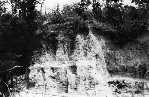
Figure 11--Schematic profile of volcanic-ash exposure north of DeSoto, SW NE NE sec. 21, T. 12 S., R. 22 E., in 1984.
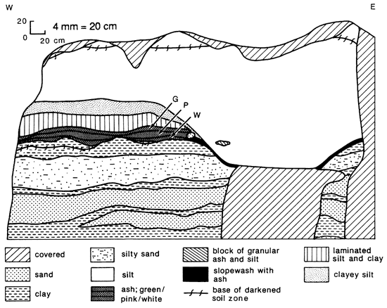
An environmental reconstruction for the sediments within the terrace fill is complicated by lack of knowledge as to the proximity of a continental glacier. The lower alluvial sequence in which the paleosol is formed may have been deposited during any period of time between the late Kansan and early Illinoian. The alluvial character of these sediments is clearly shown by particle-size analysis (fig. 12). Within the paleosol, this character is somewhat damped, but still obvious. The ash is deposited directly on the eroded surface of the paleosol (where present) or on the uppermost alluvial clay unit. The contact is very sharp, but irregular. As can be seen from the particle-size graph, the white, airfall ash is coarser than the overlying salmon- and green-colored zones. Both the white ash and salmon zone consist of nearly pure glass. The green zone contains substantially more clay and is highly plastic. This material was probably derived from slopewash soon after the original ash fall. Wilcox (1965) has stated that
"… environments favorable for preservation of a new ash mantle are those in which the normal sedimentation … was continuous. Among continental environments [in which] one would therefore expect to have most chance of finding ash beds … [are] lakes, bogs, depressions and valley bottoms."
Indeed, the highly clay-enriched zone above the ash has been interpreted as lacustrine sedimentation by Ula Moody of Kilgore College in Texas (personal communication, 1985). The sediment in this zone breaks along horizontal partings and consists of silt and clay laminae of millimeter scale. Either concurrently or shortly thereafter, a channel was created running approximately parallel with the present terrace face. Occasional chunks of alluvial sediment can be seen within the lower portions of the loess fill within the channel. A fine trail of ash is visible lining both sides of the apparent channel in this cut; thus ash was being eroded out of the channel wall and was coating the bank. This is the main evidence for the direction in which the channel ran, since it is hard to imagine ash coating both the cut-bank and point-bar sides of a channel. A few cores taken from the upper surface substantiate the existence of an east-west channel. A thick loessal cover was then deposited over the entire area, filling the channel completely, during the Illinoian and/or Wisconsinan. A modern soil is developing within this loess.
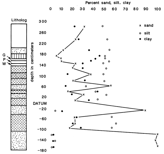
Figure 12--Variation of particle size with depth, De Soto ash exposure. the depths shown are representative and are not actual sample depths. Datum was chosen as the base of the profile shown in the preceding figure and the lithology uses the same symbols. Above datum, the numbers are averaged from several analyses; those below datum are from single analyses. The uppermost analysis is from the modern soil. The loess is quite variable, with clay and sand percentages each ranging from 20 to 30; this variability does not correlate with depth. Clay increases from the base of the loess to the ash. Note the sharp increase in particle size from the colored, secondary ash just above the 140-cm depth to the white, primary ash at the 140-cm depth. Below the ash, the alluvial character of the sediment is obvious, though pedogenic processes have somewhat dampened the size swings and increased the silt content of the sands above datum.
Boellstorff, John, 1976, The succession of late Cenozoic volcanic ashes in the Great Plains--a progress report; in, Guidebook, 24th Annual Meeting Midwestern Friends of the Pleistocene; Stratigraphy and Faunal Sequence-Meade County, Kansas; May 22-23, 1976; C. K. Bayne, ed.: Kansas Geological Survey, Guidebook Series 1, p. 37-71. [available online]
Carlson, William A., 1952, Quaternary geology and ground-water resources of the Kansas River valley between Newman and Lawrence, Kansas: M.S. thesis, University of Kansas, 94 p.
Davis, Stanley N., 1951, Quaternary geology and ground-water resources in the vicinity of Topeka, Kansas: M.S. thesis, University of Kansas, 74 p.
Davis, Stanley N., and Carlson, William A., 1952, Geology and ground-water resources of the Kansas River valley between Lawrence and Topeka, Kansas: Kansas Geological Survey, Bulletin 96, part 5, p. 203-276. [available online]
Dubé, Thomas E., 1985, A tentative Midcontinent marine Quaternary chronology and correlation to the Sierra Nevada: Institute of Tertiary-Quaternary Studies, 1983 TER-QUA Symposium Series 1, Lincoln, Nebraska, p. 75-88.
Dufford, Alvin E., 1958, Quaternary geology and ground-water resources of the Kansas River valley between Bonner Springs and Lawrence. Kansas: Kansas Geological Survey, Bulletin 130, p. 1-96. [available online]
McCrea, R. O., 1954, Geomorphic effects of the 1951 Kansas River flood: M.S. thesis, University of Kansas, 68 p.
Holien, Christopher W., 1982. Origin and geomorphic significance of channel-bar gravel of the lower Kansas River: M.S. thesis, University of Kansas. 128 p.
Izett, Glen A., and Wilcox, Ray E., 1982, Map showing localities and inferred distributions of the Huckleberry Ridge, Mesa Falls, and Lava Creek ash beds (Pearlette family ash beds) of Pliocene and Pleistocene age in the western United States and southern Canada: U.S. Geological Survey, Miscellaneous Investigations Series, Map I-1325.
Izett, Glen A., Wilcox, Ray E., Powers, H. A., and Desborough, G. A., 1970, The Bishop ash bed, a Pleistocene marker bed in the western United States: Quaternary Research, v. 2, p. 554-578.
Mankinen, E. A., and Dalrymple, G. B., 1979, Revised geomagnetic polarity time scale for the interval 0-5 m.y.B.P.: Journal of Geophysical Research, v. 84, p. 615-626.
Reynolds, Richard Lee, I975, Paleomagnetism of the Yellowstone tuffs and their associated air-fall ashes: Ph.D. dissertation, University of Colorado, 268 p.
Smith, Lee Anderson, 1985, Marine and continental Quaternary event sequence in a time framework: Institute for Tertiary-Quaternary Studies, 1982 TER-QUA Symposium Series 1, Fort Worth, Texas, p. 9-20.
van Eysinga, F. W. B., 1978, Geologic time scale, 3rd edition: Elsevier Scientific Publishing Company, 1 sheet.
Wilcox, Ray E., 1965, Volcanic-ash chronology; in, The Quaternary of the United States, Herbert E. Wright, Jr., and David G. Frey, eds.: Princeton University Press, New Jersey, p. 807-816.
| miles | Continue east on Leavenworth County road 26. |
|---|---|
| 19.8 | The road leaves the river valley and climbs to the upland. |
| 20.8 | Turn right on Leavenworth County road 32. |
| 22.8 | Return to valley bottom. Turn right at T-junction: private road entering Loring quarries. |
| 23.5 | Gate to Southeastern Public Service Company Midcontinent Underground Storage Company, Bonner Springs Plant. Drift-shaft mining of limestone has created a system of large tunnels and chambers now used for controlled-environment storage. Return eastward. |
| 24.3 | Rejoin Leavenworth County road 32; continue east. |
| 25.2 | The two terrace levels visible here were mapped as the Buck Creek and Newman surfaces by A. E. Dufford (1958). |
| 27.0 | Cross Wolf Creek. |
| 27.7 | Town of Bonner Springs. |
| 27.8 | Join K-32; continue east. |
| 28.2 | Turn left (south) on K-7. |
| 28.7 | Cross the Kansas River. |
| 29.4 | Turn left (east) on 43rd Street. |
| 30.0 | Turn left (north) on private road to Builders Sand Company-Plant 2. |
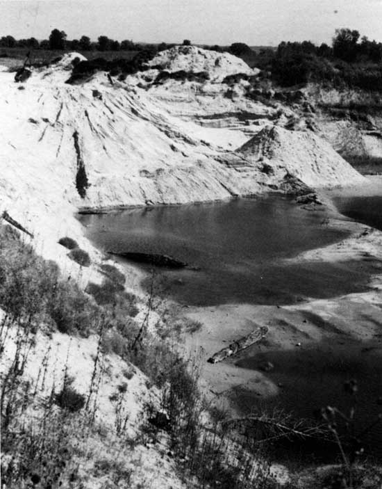
| 30.3 | Max Brown sand pit on the right (east; fig. 13). Although now reclaimed by vegetation, the bottom of this pit (c. 13-m [43-ft] depth) when freshly excavated exposed several large logs (30-70-cm [12-28-inch] diameter) of Quercus sp. (white-oak group), one of which had been beaver-chewed prior to burial. A radiocarbon date of 2,395±65 yrs B. P. (WIS-1030) was obtained on the outer 20 rings of a 40-cm (16-inch)-diameter specimen. Overlying sands are crossbedded and contain many clay balls and occasional modern bison bones. |
| 30.5 | Office and scale house-Builders Sand Company. |
| 30.9 | STOP 15A--River's edge; SW SE sec. 28, T. 11 S., R. 23 E., Edwardsville 7 1/2-min quadrangle. |
Figure 13--A view of the now-abandoned sand pit operated by Mr. Max Brown until 1982. The pit, excavated in Holliday fill, exposed several large Quercus sp. (white-oak group) logs at a depth of approximately 13m. One specimen yielded a radiocarbon date of 2,395±65 yrs B.P. (WIS-1030; photo by W. C. Johnson).
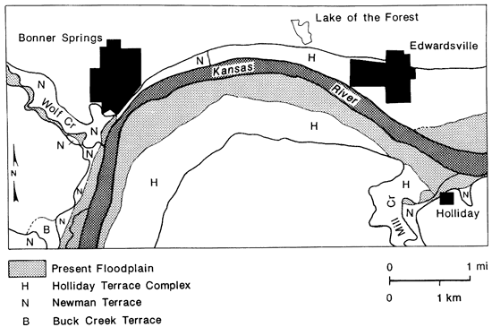
In recent years the north (left) bank of the Kansas River immediately east of Bonner Springs and south of the Lone Star Cement Company has provided an interesting exposure of Newman terrace, Holliday terrace, and recent inset fill. This exposure in conjunction with that near Wamego (Stop 5), offers an impression of the similarities and dissimilarities existing within Newman and Holliday terrace fill as well as the varying complexity of the contact between the two. The exposure is best viewed from the opposite bank, i.e. here at the Builders Sand Company plant. Figure 14 depicts the distribution of alluvial surfaces in the Bonner Springs-Edwardsville reach.
Figure 14--Map of alluvial surfaces in the Bonner Springs-Edwardsville Vicinity. Stop 15 begins approximately 1 km (.6 mi) east of Bonner Springs (from Holien, 1982).
| miles | Return to K-7 and north across Kansas River bridge to K-32. |
|---|---|
| 33.5 | Turn east on K-32. |
| 34.4 | Turn right (south) on Swingster Road; bear right. |
| 34.4 | Turn left (south) onto gravel road. |
| 34.5 | STOP 15B--Bonner Springs exposure; NW SE sec. 28, T. 11 S., R. 23 E., Edwardsville 7 1/2-min quadrangle. |
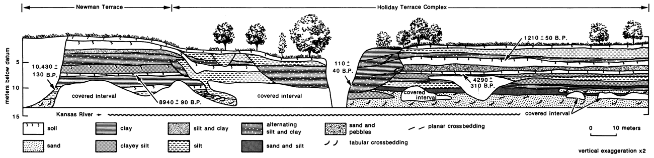
Cut-bank Exposure--Paleosols are a major stratigraphic feature within the exposure (figs. 15, 16, and 17) and display temporal and spatial patterns throughout the east-central Plains (see Johnson and Martin, this volume). Within the Newman fill the well-developed, lowermost paleosol produced an early Holocene date of 10,430±130 yrs B.P. (Beta-2931) from a humate sample taken 60 m (198ft) west of the modern gully and 8.8 m (29 ft) below the surface. Logs from the water wells drilled immediately north of the exposure indicate that more than 15 m (50 ft) of alluvial sediments underlie this paleosol. A weakly developed soil approximately 2 m (7 ft) higher in the fill produced a radiocarbon date of 8,940±90 yrs B.P. (DIC-3210) on humates as well. The lowermost paleosol in Holliday fill was sampled for radiocarbon dating 110 m (363 ft) east of the modern gully and 5.2 m (17 ft) below the surface, producing an assay of 4,290±310 yrs B.P. (Beta-2159) on humates. The paleosol above the latter dated at 1,210±50 yrs B.P. (DIC-3209), again from humates. Discharge from the Bonner Springs waste-treatment plant, completed within the last year, has expanded the modern gully dramatically, exposing the alternating silt and clay layers comprising the recent fill. The outer five rings of a Salix sp. (willow) log exposed at a depth of approximately 6 m (20 ft) within the gully (fig. 18) were radiocarbon dated at 110±40 yrs B.P. (DIC-3255), verifying the relative youth of the cut and fill. This sediment is most likely derived from the Mission Creek drainage, the channel of which was diverted eastward along the north valley wall when the railroad and highway were constructed.
Figure 15--Stratigraphy of Newman fill. The lower dark zone in the foreground (arrow) is a well developed paleosol, radiocarbon dated at 10,430±130 yrs B.P. (BETA-2931). Alternating silt and clay strata indicative of overbank flood events arc visible approximately 4 m above the paleosol. Exposed sediments in the middle ground consist of Holliday fill overlain by recent flood and tributary deposits. One of the major fossil-producing gravel bars (Davis Bar) is partially submerged in the distance (photo by W. Dort, Jr.).
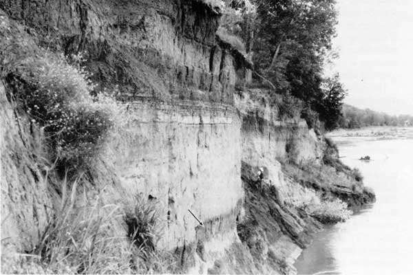
Figure 16--The contact between Newman fill (left) and the inset Holliday fill (right). The paleosol visible in the Holliday fill has been radiocarbon dated at a location approximately 100 m downstream (left) at 1.210±50 yrs B.P. (DIC-3209: photo by W. Dort , Jr.).
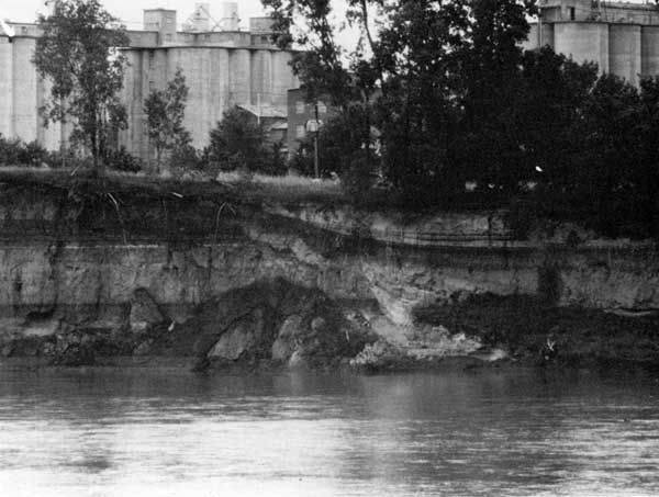
Figure 17--Alluvial stratigraphy of the Bonner Springs exposure. This left (north) bank exposure consists of three major units: Newman, Holliday, and intervening recent fill (modified from Holien, 1982). [A larger version of this figure is available.]
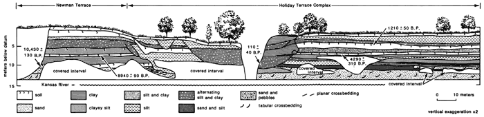
Figure 18--Recent (historical) fill exposed in a gully once occupied by Mission Creek and now by effluent from the Bonner Springs Waste-water Treatment Plant. The 60-cm-diameter Salix sp. (willow) log (arrow) exposed has been radiocarbon dated at 110±40 yrs B.P. (DIC-3255; photo by W. C. Johnson).
The major stratigraphic units exposed above low-flow stage within the Newman and Holliday fills were analyzed for their particle-size distribution via the hydrometer method. Both fills are dominated by the silt fraction (fig. 19). Those clays present occur primarily as medium-fine clays, i.e. coarse clays are the smaller fraction. Although silt-size material comprises the bulk of the fills, Newman fill contains more clay than the siltier, sandier Holliday fill. A similar relationship was noted at the Wamego exposure (Bowman, 1985).
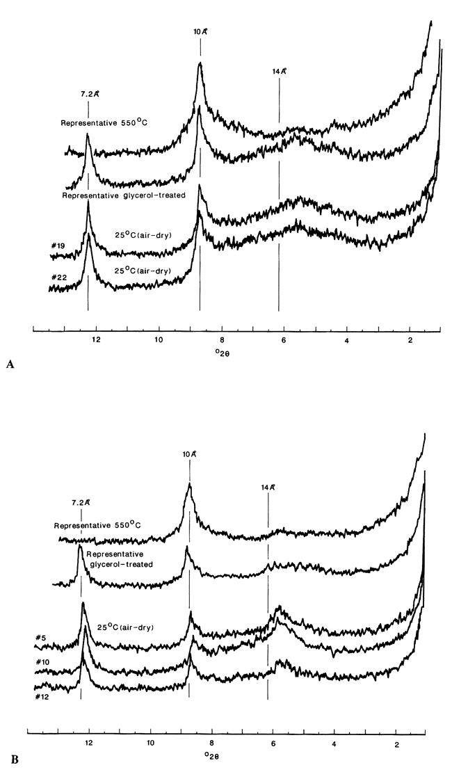
An x-ray diffraction (xrd) analysis of the various fine-sediment fractions within the two fills produced interpretable differences in the whole-clay fraction ( < 2u). Clays of both fills are dominated by kaolinite and illite, with lesser amounts of mixed-layer (10-18Å) types (fig. 20). The diffraction patterns shown differ from the <5u fraction, which contains somewhat more of the mixed-layer species of clay. The similarity in clay composition between the fills is explained by the small time difference between the two, precluding significant alteration in the suite of clays via weathering. The source area is essentially the same. XRD patterns of the whole-clay fraction from the two fills exposed near Wamego (fig. 6) were similar to one another but different from this exposure: the clays are dominated by mixed-layer minerals, rather than kaolinite and illite. At this time the mineralogic differences in the whole-clay fraction between the fills here and at Wamego can not be resolved because the bedrock is too interbedded (limestone and shale) to initiate the differences observed. Further, the Pierre shales of the headwaters do not correlate with the fills near Wamego: the former is dominated by illite and the latter by montmorillonite.
Figure 19--Particle-size distribution of Newman and Holliday fills exposed at Bonner Springs.
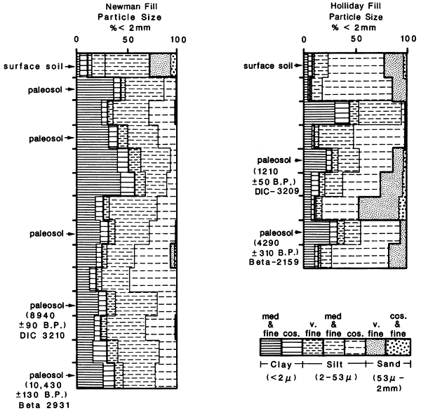
Figure 20--X-ray diffraction patterns of the whole clay fraction (< 2u) from the bonner Springs riverbank exposure. Clays are dominated by illite and kaolinite, with lesser amounts of mixed-layer clays (10-18 Å). Compare with data from Stop 5 (fig. 6). A, Holliday fill; B, Newman fill.
The bottomland south of the exposure and river channel is composed entirely of modern floodplain and Holliday terrace. A scarp which varies from having a sharp to rather subtle relief separates the two surfaces. At the edge of the Holliday terrace is the abandoned Max Brown sand pit (mile 30.3). This date of 2,395±65 yrs B.P. (WIS-1030) obtained on Quercus sp. stem material is consistent with the two dates obtained from Holliday fill in the exposure along the north (left) bank. However, note that the paleosol(s) present in the Holliday fill exposed on the opposite bank are not present in the Max Brown pit profile.
Gravel Bars--The composition of the gravel comprising the bars, from a sample of 3,600 clasts, is 61% limestone, 30% chert, 4% quartz, and 3% igneous and metamorphic rocks. The remaining lithologies represented are mudstone, sandstone, carbonate concretions, K-feldspar, Sioux quartzite, and black shale. Sources include locally exposed formations, the Ogallala Formation of west-central Kansas, and glacial deposits.
Little of the material eroded by the ancestral Kansas River before Kansan time is believed to be present in the Kansas River valley today. No alluvial deposits of this age are recognized in the area and material eroded during this initial stage of development of the Kansas River has been effectively "flushed out'' of the system. Deposits of Kansan age represent a significant development in the Kansas River system. Parts of the Kansas River valley were eroded to their maximum depth during this time. Large quantities of glacial meltwater not only eroded deeply into the local bedrock, thereby incorporating it into the alluvium, but also reworked glacial till and outwash, incorporating them into the alluvial deposits. Runoff of glacial meltwater undoubtedly transported high-level chert gravel into the fluvial system. Due to a breach in the Flint Hills drainage divide by glacial meltwater, sediments derived from the Ogallala Formation were introduced into the lower Kansas River valley.
Coarse-grained material consisting of cobbles and boulders accumulated at the base of the alluvium as large volumes of water eroded the bottom of the bedrock valley and had the capacity to transport coarse gravel. As the discharge became less, the coarse-grained material was deposited and concentrated in the lower portion of the alluvial fill, some of it being sorted by the meltwater. Tributary streams deepened their valleys, eroding into local bedrock and transporting coarse gravel to the Kansas River. These streams drained the upland areas and high-level chert gravel and glacial deposits were eroded and eventually incorporated into the Kansas River alluvium.
After the retreat of the Kansan glacier, the Kansas River became the only mechanism of sufficient force to erode, transport, and rework gravel stratified within its alluvium. Discharge of the Kansas River is not believed to have been greatly increased in lllinoian time, but another period of degradation and increased fluvial activity is proposed for Wisconsinan time when more coarse gravel was probably introduced from the surrounding area into the river valley. The gravel within the channel became increasingly concentrated as a lag deposit while fine-grained material previously associated with it was in large part flushed from the system.
As the Kansas River migrated across its valley, previously deposited alluvium was eroded and introduced into the river channel. Coarse gravel present within the alluvium and often found in a stratified bed became concentrated as a lag deposit on the bottom of the active channel. High-flow events further acted to sort this coarse-grained material which is eventually buried due to channel migration and alluviation. The coarser-grained material is continually being reworked to a lower position in the valley alluvium during periods of degradation of the Kansas River. Thus the gravel on the channel bars is exposed for only a brief time before it is buried within the river alluvium, possibly to be exposed again at some later time because of ongoing stream activity.
Gravel bars in the Kansas River in the vicinity of the Bonner Springs site are producing a rich fauna of Pleistocene and Holocene mammals (fig. 21). Although very little has been found in situ, the Kansas River localities still provide our best information concerning the late Pleistocene and early Holocene fauna of eastern Kansas. Martin and others (1979) provided a review of the paleontological data from the Kansas River, although many significant specimens have been found since. Examples of three specimens from the Bonner Springs reach are shown in fig. 22. Presently, radiocarbon assays are pending on a Cervalces (stagmoose) antler and a human femur. All bones of apparent late Pleistocene and early Holocene age are notably permineralized. A remarkably complete sequence of projectile points, also from these gravel bars, contributes new information concerning the distribution of types of projectile points in Kansas (see Rogers and Brown and Logan, both this volume).
Figure 21--Location and species lists from bone-producing gravel bars on the lower Kansas River (amended from Rogers, 1984).
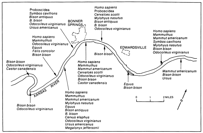
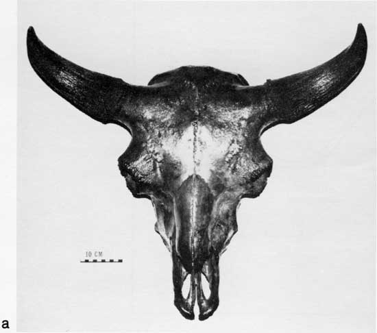
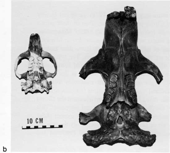
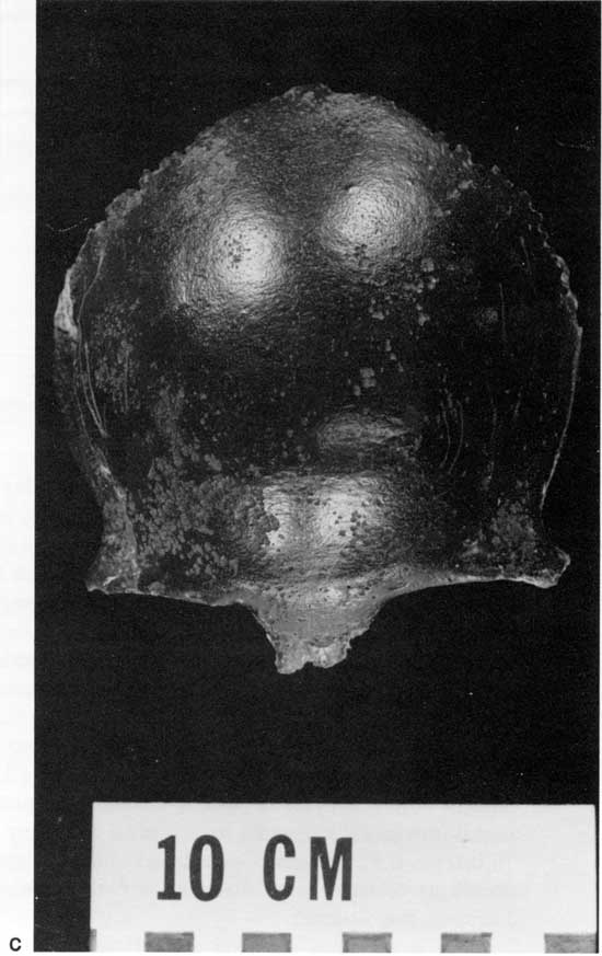
Figure 22--Three examples of fossil specimens collected from channel-bar material in the vicinity of the Bonner Springs exposure: a) skull of extinct late Pleistocene-early Holocene bison, Bison, cf. B. antiquus (University of Kansas Museum of Natural History Vertebrate Paleontology [KUVP] collection 54005). b) skull of extinct giant beaver Castoroides kansensis (KUVP 59401); skull of modern beaver Castor canadensis is presented for comparative purposes (left). c) skull cap from Homo sapiens (KUYP 54001). Photos by J. Chorn.
The oldest of the projectile points, and according to some (e.g., Haynes, 1971) the oldest clearly recognizable stone artifact type in North America, is the Clovis projectile point. Two of these points were found near Bonner Springs. Although they are generally found associated with kills of Mammuthus (mammoth) in the western United States, they have been found associated with mastodon in Missouri (Graham et al., 1981). Mammoths are a rare component of the late Pleistocene fauna near Bonner Springs, while mastodon (Mammut americanum) remains are comparatively common. The rest of the late Pleistocene fauna, e.g., Mammut, is characteristic of the Symbos-Cervalces faunal province of Martin and Neuner (1978) and is the fauna associated with Pleistocene spruce forests in the eastern United States (see Martin and Hoffmann, this volume). Other late Pleistocene mammals from the vicinity of Bonner Springs include Symbos cavifrons (woodland musk ox), Cervalces (stagmoose), and Mylohyus sp. (extinct peccary) among others (table 1). This fauna indicates the environment the Clovis hunters were occupying in eastern Kansas was typical of the Symbos-Cervalces faunal province. This faunal province disappeared from Kansas and many of its component mammals became extinct about 10,000 yrs B.P. The spruce woodland began to disappear about 12,000 yrs B.P.; eventually the prairie-deciduous forest ecotone that presently characterizes eastern Kansas developed (see Fredlund and Jaumann, this volume).
Table 1--Species and common-name equivalents of fauna represented by bones found at localities on the Lower Kansas River (see Fig. 21).
| Bison antiquus | late Wisconsinan or early Holocene bison |
| Bison bison | modern bison |
| Castoroides kansensis | giant beaver |
| Castor canadensis | beaver |
| Cervus elaphus | wapiti |
| Cervalces scotti | stagmoose |
| Equus | horse |
| Felis concolor | mountain lion |
| Homo sapiens | man |
| Mammut americanum | American mastodon |
| Mammuthus | mammoth |
| Megalonyx jeffersonii | groundsloth |
| Mylohus nasutus | woodland peccary |
| Odocoileus virginianus | white-tailed deer |
| PROBOSCIDEA | elephant |
| Symbos cavifrons | woodland musk ox |
| Ursus | bear |
| Ursus americanus | black bear |
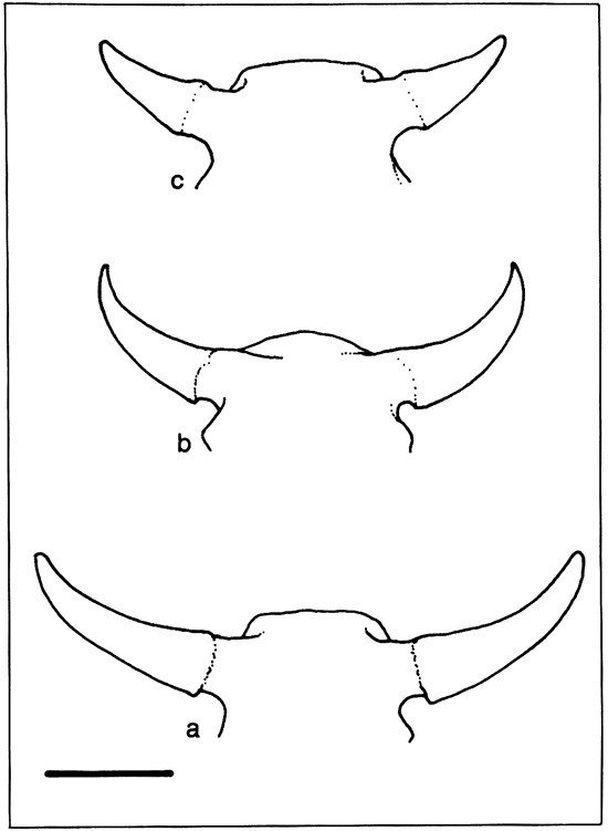
Bison is the most common early Holocene faunal taxon. This contrasts with the rarity of late Pleistocene bison in these deposits: it is represented only by two skulls, one from near Kansas City and another at the Bonner Springs site. An abundance of bison skulls intermediate in size, between typical Bison antiquus and the modern B. bison correlates well with an abundance of early Holocene lithic types found near DeSoto and Bonner Springs. Many of these lithic types are usually associated with bison hunters in western Nebraska and Wyoming. Research on Woodland and Archaic sites in the eastern Kansas region has not produced either an abundance of bison remains or bison-kill sites. It appears from the collections that early Holocene bison are more common than are late Holocene bison. This relationship may provide evidence that prairie expansion in this region began during the early Holocene especially given that most alluvial fill is late Holocene in age. The late Pleistocene-Holocene size reduction of bison is well documented (Schultz and Frankforter, 1946; Schultz and Martin, 1970). The range in size of bison bones found on gravel bars near Bonner Springs suggests that a nearly continuous sequence is present, and the discovery of in situ specimens should make a local biostratigraphy possible. Fig. 23 illustrates the presumed sequence of bison skulls.
Figure 23--Sequence of bison skull-horn complexes from the lower Kansas River. a) Pleistocene Bison sp., cf. B. antiquus, KUVP 9905. b) early Holocene B. bison (large variety), KUVP 65707. c) late Holocene B. bison, KUVP 54010. Scale bar is 25 cm (from Rogers and Martin, 1983; reprinted from Transactions of the Nebraska Academy of Sciences with permission).
Many of the bones are found in a well-preserved state and have delicate features still intact, indicating transport only a very short distance, and, consequently, a nearby source. Two bison skulls, B. bison and B. antiquus, collected by C. Holien on a bar immediately upstream from Bonner Springs, as well as those collected by others, have been recovered filled with sediment consisting of fines and numerous pebbles and cobbles wedged between bones of the inner skull.
The paleoindian period is represented by a number of projectile points. A Clovis projectile point (Rogers and Martin, 1982) was found by R. Smith, U.S. Army Corps of Engineers, on the north bank in this reach (fig. 24A). This artifact, like the other artifacts found on the gravel bars of the Kansas River, had almost certainly been transported by the river and was not recovered in situ. The gray flint from which the artifact was made is probably local in origin as it contains Paleozoic fossils typical of cherts in eastern Kansas. A second Clovis projectile point (fig. 24B) was found by F. Richardson of DeSoto on a gravel bar in the Kansas River upstream of that town. The specimen is the proximal end of the projectile point. The shape and size of the specimen are quite unlike the dimensions of Meserve or Dalton projectile points found in the area.
Figure 24-Projectile points recovered from gravel bars in the lower Kansas River channel. A) Clovis projectile point found by R. Smith on the north bank immediately above Bonner Springs. B) second Clovis projectile point found by F. Richardson on the south bank immediately upstream of De Soto. C) Meserve or Dalton projectile point typical of several found on lower Kansas River. D) Milnesand projectile point found by F. Richardson at same locality as points b and e. E) Hell Gap projectile point recovered by F. Richardson at same locality as points band d. Scale bar is 2 cm (from Rogers and Martin, 1982 [A, Kansas Academy of Science], 1983 [B-E, Nebraska Academy of Science]).
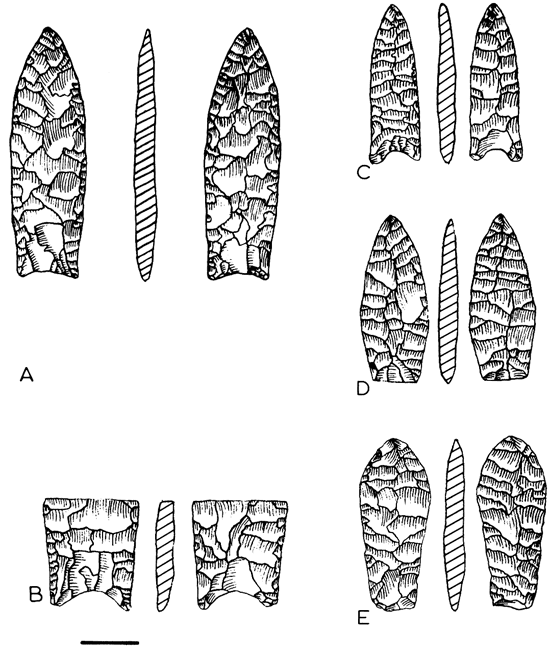
A Hell Gap projectile point (fig. 24E) was recovered by Richardson on the same gravel bar on which he found the Clovis projectile point. Radiocarbon dates on the Hell Gap cultural complex in Wyoming were 9,600±230 yrs B.P. and 9,650±250 yrs B.P. at the Sister's Hill site and 9,830±350 yrs B.P. and 10,060±170 yrs B.P. at the Casper site (Frison, 1978, p. 23). A Milnesand projectile point (fig. 24D) was found by Richardson on the same gravel bar as the Hell Gap and Clovis projectile points. The artifact exhibits transverse parallel flaking, and the removal of thinning flakes has given the base a beveled appearance that is typical of Milnesand projectile points (Sellards, 1955, p. 343). Although the Milnesand "type site" is located in Texas, Wormington (1957, p. 112) indicated that Milnesand projectile points have been found in Iowa. The Lime Creek site in southwestern Nebraska (Schultz and Frankforter, 1948) has yielded a projectile-point type that is probably Milnesand (Wormington, 1957, p. 120) in the same stratigraphic zone as a Scottsbluff projectile point. The Milnesand projectile-point type was present at the Olsen-Chubbuck site in eastern Colorado (Wheat, 1967) and was also in association with the Scottsbluff projectile-point type. The Olsen-Chubbuck site has a radiocarbon date on bone collagen of 8,200±500 yrs B.C. (Wheat, 1972).
Several specimens of Meserve or Dalton projectile points (e.g., fig. 24C) were found by Richardson on gravel bars of the Kansas River, including the Bonner Springs area. Meserve or Dalton projectile points were first found in situ at the Meserve site (Barbour and Schultz, 1932) near Grand Island, Nebraska, in association with extinct bison. Very similar projectile points were later found in situ in Missouri where they were named Dalton projectile points.
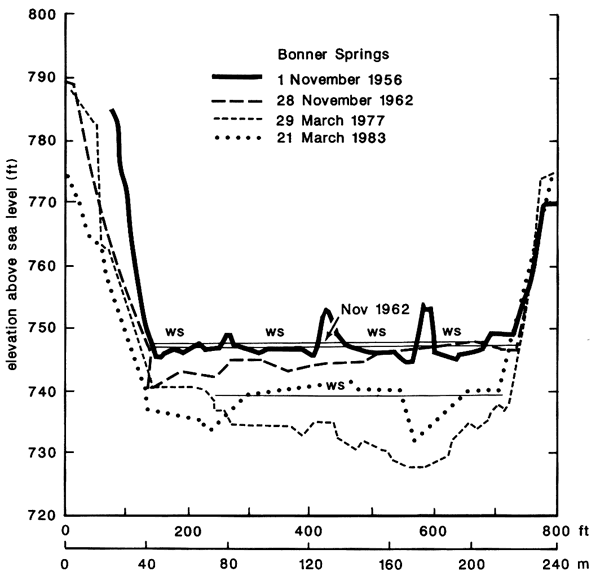
Contemporary Changes in the lower Kansas River--In contrast to the rapid lateral cutting of the Kansas River in the vicinity of Wamego (Stop 5), unusual channel degradation has been occurring for the last 30 yrs in the lower reaches of the river. The reason(s) for the degradation in this reach is still uncertain, but evidence that it exists has been documented by several different means. Rating curves from a gaging station at Bonner Springs first drew attention to the problem, especially when no such trend was evident at upstream stations such as that at Lecompton (fig. 25). More than half of this degradation occurred between 1952 and 1966, but has continued to present. The same trend is apparent in subsequent water-surface profiles. Comparison of consecutive surveyed channel cross sections at Bonner Springs (fig. 26) demonstrates the lowering of water surfaces recorded at that station. A clay body producing in situ Alnus sp. (alder) stumps, one of which was dated at 5,030±90 yrs B.P. (Beta-2160), found exposed in the channel bed near Bonner Springs at low water suggests the river is degrading its channel and is presently eroding into alluvium of at least mid-Holocene age.
Figure 25--Discharge-rating curves for two gaging stations, Lecompton and Bonner Springs, on the lower Kansas River. A) Established between 1950 and 1976, family of rating curves for Lecompton station shows little variation, indicating a relatively stable cross section. B) Family of rating curves computed for Bonner Springs station from 1950 to 1973 (and since) indicates progressive downcutting at the section (from Holien, 1982).
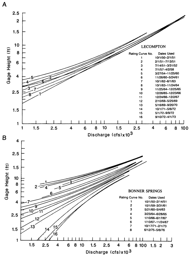
Figure 26--Comparison of successive cross section surveys at the Bonner Springs section conducted in 1956, 1962, 1977, and 1983. The progressive increase in depth, also reflected in the temporal pattern evident in the rating curves, relates to both gravel-bar preservation and recent downcutting into mid-Holocene or older deposits (data from U.S. Army Corps of Engineers, 1983).
The Army Corps of Engineers has contended that the downcutting (and widening) of the river may be due to commercial dredging activity, which is very common on the lower Kansas. Such operations were suggested to be removing more sand and gravel than was being replenished. Simons, Li, and Associates (1984), in a study of the lower Kansas River, indicate that sand and gravel dredging seems to be the major cause of channel degradation and bank erosion. Others have refuted this cause, citing the closure of major reservoirs on the river which would reduce the sediment load, thereby resulting in unfulfilled transport capacity. Other factors such as tectonics and land-use change may have a role as well.
Because of degradation, the water surface has been lowered more than 2m (7 ft) in the Bonner Springs area in recent years, resulting in a decreased frequency of flow over the gravel bars. Consequently, the bars have become increasingly stable.
(The preceding has been abstracted, in part, from Rogers and Martin, 1983, and Holien, 1982).
Barbour, E. H., and Schultz, C. B., 1932, The mounted skeleton of Bison occidentalis and associated dart-points: Bulletin of the University of Nebraska State Museum, v. 1, p. 263-270.
Beck, H. V., 1959, Geology and ground-water resources of the Kansas River valley between Wamego and Topeka vicinity: Kansas Geological Survey, Bulletin 135, 88 p. [available online]
Beard, J. H., 1982, Pleistocene paleotemperature record based on planktonic foraminifera. Gulf of Mexico: Transactions of the Gulf Coast Association of Geologists Society, v. 19, p. 535-553.
Bowman, M. W., 1985, A disparity in the rate of lateral channel cutting between two reaches of the Kansas River: M.S. thesis, University of Kansas, 247 p.
Dort, W., Jr., 1980, Historic channel-change maps: U.S. Army Corps of Engineers, Bank Stabilization Study, Kansas City District, 51 p.
Fader, S. W., 1984, Ground-water in the Kansas River valley, Junction City to Kansas Kansas: Kansas Geological Survey, Bulletin 206, part 2, 12 p. [available online]
Frison, G. C., 1978, Prehistoric hunters of the High Plains: New York, Academic Press, 457 p.
Graham, R. W., Haynes, C. V., Johnson, D. L., and Kay, M., 1981, Kimmswick--a Clovis-Mastadon association in eastern Missouri: Science, v. 213, p. 1,115-1,117.
Grissenger, E. H., and Murphy, J. B., 1983, Present channel stability and late Quaternary valley deposits in northern Mississippi; in, Modern and Ancient Fluvial Systems, J. D. Collinson and J. Lewin (eds.): Blackwell Scientific Publications, Oxford, p. 241-251.
Haynes, C. V., 1971, Time, environment and early man: Arctic Anthropology, v. 8, p. 3-14.
Holien, C. W., 1982, Origin and geomorphic significance of channel-bar gravel of the lower Kansas River: M.S. thesis, University of Kansas, 128 p.
Martin, L. D., and Neuner, A. M., 1978, The end of the Pleistocene in North America: Transactions of the Nebraska Academy of Sciences, v. 6, p. 117-126.
Martin, L. D., Whetstone, K. N., Chorn, J. D., and Fraily, C. D., 1979, Survey of fossil vertebrates from east-central Kansas: Kansas City, U. S. Army Corps of Engineers, Kansas River Bank Stabilization Study, 44 p.
McCrae, Robert, 1954, Geomorphic effects of the 1951 Kansas River flood: M.S. thesis, University of Kansas.
Reed, E. C., and Dreezen, V. H., 1965, Revision of the classification of the Pleistocene deposits of Nebraska: Nebraska Geological Survey, Bulletin. v. 23, p. 1-65.
Rogers, R. A., 1984, Kansas prehistory--an alluvial geomorphological perspective: Ph.D. dissertation, University of Kansas, 321 p.
Rogers. R. A., and Martin, L. D., 1982, A Clovis projectile point from the Kansas River: Transactions of the Kansas Academy of Science, v. 85, p. 78-81.
Rogers. R. A., and Martin, L. D., 1983, American Indian artifacts from the Kansas River: Transactions of the Nebraska Academy of Sciences, v. 11, p. 13-18.
Schultz. C. B., and Frankforter, W. D., 1946, The geologic history of the bison in the Great Plains, a preliminary report: Bulletin of the University of Nebraska State Museum, v. 3, p. 1-10.
Schultz, C. B., and Martin, L. D., 1970. Quaternary mammalian sequence in the Central Great Plains; in, Pleistocene and Recent Environments of the Central Great Plains, W. Dort, Jr. and J. K. Jones, Jr. (eds.): Lawrence, University of Kansas Press, p. 341-353.
Sellards, E. H., 1955, Fossil bison and associated artifacts from Milnesand, New Mexico: American Antiquity, v. 20, p. 336-344.
Simons, Li, and Associates, 1984, Analysis of channel degradations and bank erosion in the lower Kansas River: Simons, Li, and Associates, prepared for the U.S. Army Corps of Engineers, Kansas City District, 291 p.
Wheat, J. B., 1970, A paleoindian bison kill: Scientific American, v. 216, p. 44-52.
Wheat, J. B., 1972, The Olsen-Chubbuck site--a paleoindian bison kill: Memoir of the Society for American Archaeology, no. 26. p. 1-180.
Wormington, H. M., 1957, Ancient man in North America: Denver, Peerless Printing Company, 322 p.
Zeller, D. E., (ed.). 1968, The stratigraphic succession in Kansas: Kansas Geological Survey, Bulletin 189, 81 p. [available online]
Next--Terminal zone of continental glaciation
Kansas Geological Survey
Comments to webadmin@kgs.ku.edu
Web version updated March 27, 2010. Original publication date 1987.
URL=http://www.kgs.ku.edu/Publications/Bulletins/GB5/index.html