![]()
![]()
![]()
Prev--Remote sensing and geophysical investigations || Next--Kansas River terraces
The association of soils and geomorphic surfaces is examined in an effort to better understand the complex of apparent alluvial terraces in the Kansas River valley. Increasingly in recent years, the simple assignment of Wisconsinan through Kansan ages to Newman through Menoken terraces has come into question. Data from soils for example, including R/C dates on buried paleosols in the Newman terrace fill, indicate that the Newman terrace is Holocene in age. Conclusions such as this call into question not only the Wisconsinan age of the Newman but the entire terrace chronology. The complexity of geomorphic forms and processes and of soil types and genetic pathways in the study area argue strongly for landscape instability through time. The notion that terraces represent stable landscapes interrupted by major periods of instability seems untenable given the complex associations of soils and parent materials on these terraces. More likely it appears that these surfaces have been undergoing continual change and we are just now beginning to appreciate the complexity of natural processes in the landscape accompanying these changes.
The authors have long felt the need to compile a map of river terraces with cross sections showing their associated soils for the Kansas River valley. Impetus for such a compilation comes from the fact that existing information on alluvial terraces is scattered among several publications, and no previous report links the soils to landforms in the river valley. Additionally we assumed that any such compilation would aid in reinterpretation of the simple terrace chronology that pervades much of the literature for streams in this region.
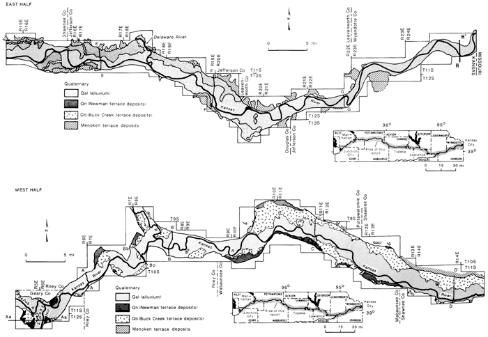
The study area includes the Kansas River valley and adjacent upland areas from Junction City, downstream 170 mi (272 km) to Kansas City, Kansas (fig. 1). The Kansas River flows eastward through this area of northeastern Kansas, crossing the Flint Hills, the glaciated region, and the Osage cuestas of the Central Lowlands physiographic province. The surface bedrock consists of Permian sedimentary units in the Flint Hills and Upper Pennsylvanian and Lower Permian sedimentary units in the Osage cuestas region. The glaciated region is a dissected drift plain. During the pre-Illinoian glacial episodes, this area was covered by a continental ice sheet that extended slightly beyond the Kansas River in places on the south and overlapped portions of the Flint Hills on the west. The plain is underlain by Pennsylvanian and Permian bedrock units similar to those of the Osage cuestas, but thick deposits of till, outwash, and loess conceal the cuesta-type topography that prevails south of the Kansas River.
Figure 1--Map showing latest compilation of floodplains and terraces, including Menoken surfaces, between Junction City and Kansas City (map after Fader, 1974). A larger version of this figure is available.
The study area is in Thornwaite's (1948) moist, sub-humid (C2) climatic region. This continental-type climate is characterized by a large annual-temperature range and extremes in precipitation. The winters are usually short and cold, and summers are long and hot. The mean annual precipitation decreases westward across the study area, ranging from approximately 96 cm (38 inches) at Kansas City to 73 cm (29 inches) at Junction City.
Two major vegetation associations occur in the study area: tall-grass prairie and prairie-forest mosaic (Kuchler, 1964). The tall-grass prairie is in the Flint Hills region west of Topeka. This area is dominated by warm-season grasses, especially big bluestem (Andropogon gerardii), little bluestem (A. scoparius), switchgrass (Panicum virgatum), and Indian grass (Sorghastrum nutans). Eastward from the tall-grass prairie, the land is a mosaic of prairie and oak-hickory forest. Generally components of the tall-grass prairie are found on the level-to-rolling uplands with clay-rich soils. Oak-hickory forests occur on steep slopes and ravines and in areas with coarsely textured soils. The forested areas are dominated by white oak (Quercus alba), red oak (Q. borealis), shagbark hickory (Craya ovata), and bitternut hickory (C. cordiformis).
The bottomlands of the Kansas River valley usually are forested, but the species composition differs from the uplands. Here the arboreals include the rapidly growing invaders like cottonwood (Populus deltoides), willow (Salix ssp.), and hackberry (Celtis occidentalis). Shallow depressions and mud flats that are frequently flooded are characterized by wetland communities. The wetlands are preferred sites for such plants as prairie cordgrass (Spartina pectinata), smartweeds (Polygonum ssp.), docks (Rumex ssp.), and chenopods (Chenopodium ssp.).
The Quaternary landscapes of northeastern Kansas record a complex history of terrestrial deposition, erosion, and soil formation. The complexity of the Quaternary stratigraphy of the Kansas River valley is a product of this varied history.
The formal Quaternary lithostratigraphy of northeastern Kansas is based on the stratigraphy of pre-Illinoian tills and Pleistocene loesses because these deposits are regional in extent and thus provide "marker" units to which more localized fluvial units can be stratigraphically related. Recent investigations (Dort, 1985; Hallberg, 1980; Hallberg et al., 1980) have substantially revised the stratigraphy of Pleistocene tills in the east-central plains. Detailed geomorphic investigations and careful synthesis and reevaluation of previous work have led to the abandonment of the classical glacial- and interglacial-stage terms Kansas, Aftonian, and Nebraskan. A much more complex sequence of glacial deposits than previously recognized is apparent. Thus all Quaternary sediments in the Kansas River valley that are older than Illinoian are referred to in a time-stratigraphic sense as undifferentiated pre-Illinoian deposits.
Pre-Illinoian till, glaciofluvial, and glaciolacustrine deposits are the oldest Quaternary deposits that are common in and adjacent to the Kansas River valley. Till occurs on both sides of the Kansas River in high, intermediate, and low topographic positions. The till deposits are generally 3-15m (10-50 ft) thick in the area of the Kansas River and only rarely are thicker within 15 km (50 ft) of the valley. Glaciofluvial and glaciolacustrine deposits comprise the bulk of the pre-Illinoian sediments in the valley. Outwash deposits commonly are 10-20 m (33-66 ft) thick but are locally 30 m (99 ft) or more thick (Jewett et al., 1965).
Pleistocene eolian deposits, dominantly loess, but locally including sands, mantle uplands and high-terrace deposits in the Kansas River valley. Where the full eolian sequence is preserved, the deposits consist of two lithostratigraphic units: the lower Loveland loess and the overlying Peorian loess. The Loveland loess is Illinoian in age and consists of reddish- or pinkish-brown, noncalcareous silt with some clay (Frye and Leonard, 1952, p. 116). In most locations the Loveland loess is less than 3 m (10 ft) thick, and it has been greatly modified by Sangamonian and more recent soil development. The Peorian loess is Wisconsinan in age and occurs as a widespread but discontinuous blanket of yellowish-brown to yellowish-gray, noncalcareous silt and very fine sand on the uplands (Frye and Leonard, 1952, p. 128). Within the Kansas River valley, the maximum thickness of Peorian loess is approximately 5 m (17 ft) in eastern Johnson County. Peorian deposits thin to the west and generally are less than 2 m (7 ft) thick west of Jefferson County.
The Bignell Formation, a loess deposit younger than Peorian, is recognized along the Missouri River valley in northeastern Kansas. If the Bignell is present in the Kansas River valley between Kansas City and Junction City, Kansas, it is so thin that it is included entirely within the A horizon of the modern soil.
A large proportion of the Kansas River valley is composed of Pleistocene and Holocene alluvium. Four terraces have been mapped within the lower Kansas River drainage net (Davis and Carlson, 1952; McCrae, 1954; Beck, 1959; Fader, 1974; and Elks, 1979). They are, from oldest to youngest, the Menoken terrace, the Buck Creek terrace, the Newman terrace, and the Holliday terrace complex. These four terrace names have become established in the literature.
The Menoken terrace is pre-Illinoian and is the oldest Quaternary landform in the Kansas River valley. The surface of the Menoken terrace is approximately 25-30 m (83-99 ft) above the modern floodplain. Davis and Carlson (1952) suggested that sediment underlying this terrace was deposited by glacial meltwater during the retreat of Kansan glacial ice. They noted that the Menoken fill consists of coarse outwash containing cobbles and boulders at the base fining upward into thicker units of sand, silt, and clay. However, in many localities, the Menoken terrace is composed of undifferentiated till and glaciolacustrine deposits (Beck, 1959; Jewett et al., 1965; O'Connor, 1971). These deposits rest on bedrock benches at high elevations along the margins of the Kansas River valley. This report recognizes the problem of genesis of the Menoken surface. It seems increasingly accepted that the Menoken deposits and features are remnants of ice-contact deposits of various types including moraines, karnes, and outwash. The deposits and features probably are not alluvial terraces even though their proximity to the Kansas River makes them an important part of the valley landscape. Therefore we retain the term Menoken to describe an unusually amorphous form and/or series of deposits in the study area.
The Menoken surface has been severely dissected by erosion and only small remnants remain between Bonner Springs and Wamego, Kansas (fig. 1). These remnants are mantled by Loveland and/or Peorian loess.
According to Davis and Carlson (1952), a cycle of degradation and alluviation during the Illinoian resulted in the formation of the Buck Creek terrace. The surface of the terrace is approximately 11-12 m (36-40 ft) above the modern floodplain of the Kansas River. Deposits underlying the surface consist of sand and gravel which grade upward into silt and clay (Beck, 1959). The terrace surface is capped by several meters of Loveland and/or Peorian loess. A strongly developed Sangamon soil is present in the older loess and often extends down into the alluvial fill of the terrace. The absolute age of the Buck Creek fill is not known. Preliminary petrographic investigations of volcanic ash overlying the fill indicate that it is the 0.6-m.y.-old Lava Creek Bash (Geil, 1985). This identification, if supported by fission-track-dating techniques, indicates that the fill beneath the ash is much older than Illinoian.
The Buck Creek terrace is preserved as scattered remnants in the Kansas River valley between Eudora and Junction City, Kansas (fig. 1). Most of these remnants are located at the mouths of tributary streams. Lateral migration of the Kansas River during Illinoian and Wisconsinan time completely removed the Buck Creek terrace in the narrow section of the valley between Eudora and Kansas City.
The Newman terrace occurs throughout much of the Kansas River valley west of Eudora, Kansas (fig. 1). The surface of the terrace is approximately 3 m (10 ft) above the modern floodplain of the river. However, since much ofthe terrace is covered with water during severe Hoods, it is technically considered part of the floodplain (Holien, 1982).
The Newman terrace typically is a flat, poorly drained surface bordered by low natural levees (O'Connor, 1960). Unlike the topographically lower surfaces of the valley, it is not marked by old meander scars. The lower part of the alluvium underlying the Newman terrace consists of coarse sand and gravel with cobbles at the base (Beck, 1959; O'Connor, 1960). The alluvium fines upward into dark, silty clay which is found everywhere beneath the terrace surface (O'Connor, 1971). This fine-grained material may represent everything from overwash to backswamp deposits and includes filled-in former channels.
The fill of the Newman terrace has been dated at several locations in the Kansas River valley. Near Bonner Springs, radiocarbon dates of 4,290±310 yrs B.P. and 10,430±130 yrs B.P. were determined on humic acids from paleosols at depths of 5.2 m (17.2 ft) and 8.8 m (29 ft), respectively, below the terrace surface (Holien, 1982). A radiocarbon date of 7,250±110 yrs B.P. was determined on humic acids from a paleosol3.65 m (12 ft) below the surface near Wamego, Kansas (Bowman, 1985). Based on these dates, sediments of the Newmah terrace seem to have aggraded from late Wisconsinan through late Holocene.
During the late Holocene, another episode of degradation and alluviation produced the Holliday terrace complex. This terrace is approximately 2 m (7 ft) above the modern floodplain of the Kansas River and is separated from it by a small natural levee (McCrae, 1954). A complex pattern of meander scrolls and abandoned channels which have surface relief of up to 3 m (10 ft) are present on the terrace surface (Holien, 1982, p. 76). The alluvium consists of sand and silt with fine-grained silts and clays accumulating in abandoned meander scrolls and channels. The Holliday fill has yielded radiocarbon dates of about 4,090, 4,260, 2,620, 2,395, and 1,670 yrs B.P. (Johnson, 1985; this volume).
The modern floodplain is the surface which lies at a lower elevation than the Holliday terrace complex. It is characterized by channel scars that exhibit subtle relief. The floodplain sediments are generally coarser than the alluvium underlying upper portions of the terraces and consist of coarse sands, silts, and occasional sand lenses (Holien, 1982). Lateral migration of the Kansas River has removed the Holliday terrace complex at places in the river valley and as a result, the modern floodplain may be adjacent to the Newman terrace. The absolute age of the floodplain fill is not known, but it is suspected to be less than 3,000 yrs old (Bowman, 1985).
Detailed soil surveys for eight of the 10 counties in the study area were published from 1960 to 1979 (Abmeyer and Campbell, 1970; Bidwell and Dunmire, 1960; Dickey et al., 1977; Dickey, Zimmerman, and Rowland, 1977; Jantz et al., 1975; Plinsky et al., 1979; and Savesky and Boatright, 1977). Surveys for the two remaining counties are near completion and should be published in the next two to three years.
Major changes in soil classification coincided with this period of mapping, and numerous individuals worked on these reports, resulting in some disparity in the recognition and mapping of soils throughout this group of ten counties. Named soil series were correlated, on a county-by-county basis, from 1966 to 1975, but never for the Kansas River basin as a unit. Many of the name differences among counties would not occur had such a basin-wide correlation been made. The purpose of this report is to describe the relationships between soils and landscapes in the lower Kansas River valley.
The map (fig. 1) shows the latest compilation of floodplains and terraces, including the Menoken surfaces, between Junction City and Kansas City (Davis and Carlson, 1952; Dufford, 1958; Beck, 1959; and Fader, 1974). Eight cross sections (fig. 2a-h) are included that are modified somewhat from those of Fader (1974) or are supplemented as necessary to show major geomorphic surfaces and their associated soils along the length of the river in the study area. The eight cross sections, beginning with Aa-Aa' at Junction City, are taken at roughly 20-mi (32-km) intervals downstream to H-H' at Bonner Springs. Cross sections identified with upper- and lower-case letters are new to this report. Those identified with upper-case letters only are taken from Fader (1974). The interval between cross sections is less than 20 mi (32 km) in some cases, but rarely is it much more that 20 mi (32 km) anywhere along the river. The patterns that emerge provide a summary of the soil and landform associations temporally and spatially for the Kansas River valley (table 1).
Figure 2--Eight cross sections (Aa-Aa' to H-H') modified from Fader (1974) or supplemented, showing major geomorphic surfaces and associated soils along length of river in study area.
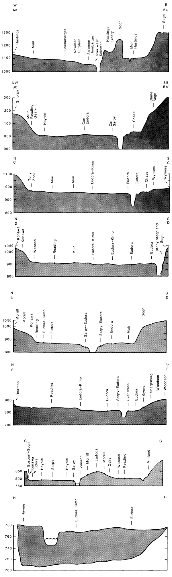
Table 1--Soils and major geomorphic surfaces in the Kansas River valley at selected cross-valley transects from Junction City to Kansas City.
| Junction City West | Aa-Aa' | Bb-Bb' | C-C' | D-D' | E-E' | F-F' | G-G' | Hh-Hh' | Principal association soils | Kansas City East |
|---|---|---|---|---|---|---|---|---|---|---|
| Holliday/floodplain | Solomon, Humbarger | Carr, Sarpy, Haynie, Ivan | Eudora, Kimo, Sarpy, Muir, Haynie | Eudora, Kimo, Sarpy | Eudora, Kimo, Sarpy, Muir | Eudora, Kimo, Sarpy | Eudora, Kimo, Sarpy, Haynie | Eudora, Kimo | Eudora, Kimo, Sarpy | Holliday/floodplain |
| Newman terrace | Sutphen, Muir, Hastings | Reading, Carr, Geary, Muir, Eudora, Chase | Muir, Tully, Zook, Chase, Eudora, Kimo | Muir, Reading, Kennebec, Wabash, Eudora | Reading, Kimo, Eudora, Muir, Wabash | Reading, Kennebec, Wabash, Judson | Reading, Wabash | Eudora, Haynie, Judson on alluvium at mouth of tributary to main valley | Muir, Reading, Wabash | Newman terrace |
| Buck Creek terrace | Shellabarger, Hastings, Geary | Smolan | Wymore, Ortello | Shellabarger, Konawa, Gymer | terrace form not preserved in main valley | Gymer, Sharpsburg | terrace form not preserved in main valley | terrace form not preserved in main valley | Gymer, Konawa, Sharpsburg | Buck Creek terrace |
| Menoken surfaces | terrace form not preserved | terrace form not preserved | Morrill, Ortello, Thurman | Konawa, Gymer, Shelby, Shellabarger, Morrill | Morrill, Konawa, Gymer | Sharpsburg, Woodson, Morrill, Pawnee, Gymer, Thurman | Konawa, Morrill, Ladoga | Morrill, Sharpsburg | Morrill, Konawa, Thurman, Sharpsburg | Menoken surfaces |
| Upland residual/glacial loess, etc. | Sogn-residuum, Tully-colluvium, Crete-loess, Hastings-loess | Sogn-residuum, Mayberry-glacial till/outwash, Hastings-loess | Sogn-residuum, Cline-residuum, Morrill, Pawnee-glacial till/outwash, Ladysmith-loess | Sogn/Vinland-residuum, Morrill/Pawnee-glacial till/outwash, Ladysmith-loess | Sogn/Martin-residuum, Pawnee/Morrill-glacial till outwash, Ladysmith-loess | Martin/Sogn/Vinland-residuum, Pawnee-till, Sharpsburg-loess | Martin/Vinland Sogn-residuum, Pawnee-till, Woodson-loess/lacustrine | Sogn/Vinland-residuum, Pawnee/Morrill-till/outwash, Sharpsburg/Polo-loess | Sogn, Martin, Vinland | Upland residual/glacial loess, etc, |
Principal soils on the Holliday terrace and modern floodplain include the Eudora-Kimo-Sarpy association. The Eudora soil is a coarse-silty Fluventic Hapludoll formed in overbank deposits (see description of Eudora Series in appendix), the Kimo soil is a clayey-over-loamy Aquic Hapludoll formed in fill deposits of oxbows, and Sarpy soil is a mixed Typic Udipsamment formed in coarse overwash mainly from the 1951 flood. Other soils include patches of 1) Haynie, which is a soil like the Eudora except that it is calcareous to the surface and has less organic matter; 2) Carr, which is a soil similar to the Sarpy but is not as coarse in texture; 3) Ivan, which is calcareous throughout and is much like the Kennebec soil (which mainly occurs on the Newman terrace); 4) Muir, which is a soil much like the Eudora but is finer in texture, darker in color to greater depths, and mainly occurs on the Newman terrace; 5) Solomon, which is calcareous throughout and is otherwise much like the Wabash soil (which mainly occurs on the Newman terrace); and 6) Humbarger, which is a soil like the Ivan but is coarser in texture (tables 1 and 2).
Table 2--Taxonomic class of soils listed in table 1.
| Carr--coarse, loamy (calcareous), mesic Typic Udifluvents |
| Chase--fine, montmorillonitic, mesic Aquic Argiudolls |
| Clime--fine, mixed, mesic Udic Haplustolls |
| Crete--fine, montmorillonitic, mesic Pachic Argiustolls |
| Eudora--coarse-silty, mixed, mesic Fluventic Hapludolls |
| Geary--fine-silty, mixed, mesic Udic Argiustolls |
| Gymer--fine, montmorillonitic, mesic Typic Argiudolls |
| Hastings--fine, montmorillonitic, mesic Udic Argiustolls |
| Haynie--coarse-silty, mixed (calcareous), mesic Typic Udifluvents |
| Humbarger--fine-loamy, mixed, mesic Cumulic Haplustolls |
| Ivan--fine-silty, mixed, mesic Cumulic Hapludolls |
| Judson--fine-silty, mixed, mesic Cumulic Hapludolls |
| Kennebec--fine-silty, mixed, mesic Cumulic Hapludolls |
| Kimo--clayey over loamy, montmorillonitic, mesic Aquic Hapludolls |
| Konowa-fine-loamy, mixed, thermic Ultic Haplustalfs |
| Ladoga--fine, montmorillonitic, mesic Mollie Hapludalfs |
| Ladysmith--fine, montmorillonitic, mesic Pachic Argiustolls |
| Martin--fine, montmorillonitic, mesic Aquic Argiudolls |
| Mayberry--fine, montmorillonitic, mesic Aquic Argiudolls |
| Morrill--fine-loamy, mixed, mesic Typic Argiudolls |
| Muir--fine-silty, mixed, mesic Cumulic Haplustolls |
| Oska--fine, montmorillonitic, mesic Typic Argiudolls |
| Ortello--coarse-loamy, mixed mesic Udic Haplustolls |
| Pawnee--fine, montmorillonitic, mesic Aquic Argiudolls |
| Polo--fine, montmorillonitic, mesic Typic Argiudolls |
| Reading--fine-silty, mixed, mesic Typic Argiudolls |
| Sarpy--mixed, mesic Typic Udipsarnments |
| Sharpsburg--fine, montmorillonitic, mesic Typic Argiudolls |
| Shelby--fine-loamy, mixed, mesic Typic Argiudolls |
| Shellabarger--fine-loamy, mixed, thermic Udic Argiustolls |
| Smolan--fine, montmorillonitic, mesic Pachic Argiustolls |
| Sogn--loamy, mixed, mesic Lithic Haplustolls |
| Solomon--fine, montmorillonitic (calcareous), mesic Vertic Haplaquolls |
| Sutphen--fine, montmorillonitic, mesic Udertic Haplustolls |
| Thurman--sandy, mixed, mesic Udorthentic Haplustolls |
| Tully--fine, mixed, mesic Pachic Argiustolls |
| Vinland--loamy, mixed, mesic shallow Typic Hapludolls |
| Wabash--fine, montmorillonitic, mesic Vertic Haplaquolls |
| Woodson--fine, montmorillonitic, thermic Abruptic Argiaquolls |
| Wymore--fine, montmorillonitic, mesic Aquic Argiudolls |
| Zook--fine, montmorillonitic, mesic Cumulic Haplaquolls |
Principal soils on the Newman terrace include the Muir-Reading-Wabash association. The Muir soil is a fine-silty mixed Cumulic Haplustoll formed in alluvium (see description of the Muir Series in the appendix); the Reading soil is a fine-silty mixed Typic Argiudoll formed in silty alluvium probably derived from natural levee deposits; and the Wabash soil is a fine, montmorillonitic Vertic Haplaquoll formed in clayey alluvium of backswamp deposits. Other soils include patches of 1) Haynie, Carr, and Eudora, which are near the Muir but are less clayey, are darkened to a shallower depth, and probably originated in overwash from Hoods; 2) Kennebec, which is a soil that merges onto the terrace from tributaries and buried soils of the Muir-Reading-Wabash association (it is unlike any of the major soils of the association being silty over a clayey substratum); 3) Judson, which is a soil like the Muir but has a wetter soil-moisture regime; 4) Kimo, which is described in the soil association of the Holliday floodplain surfaces; 5) Chase and Zook, which are soils that are like the Wabash but have less clay in their surface horizons; 6) Tully, which is formed in colluvium transported from adjacent higher valley walls and deposited at the base of steep slopes; 7) Geary and Hastings, which are similar to the Reading soil except that they have formed in loess and have drier soil-moisture regimes; and 8) Sutphen, which is like the Wabash in the upper 40 inches (l00 cm) and has a drier soil-moisture regime (tables 1 and 2).
The Buck Creek terrace is poorly preserved throughout most of the Kansas River drainage. Where it is present, it is often at the mouths of tributaries to the Kansas River, so it is difficult to define a principal soil association for the surface. At and near the type locality for the Buck Creek terrace, the soils most commonly associated on the Buck Creek surface are the Gymer, Konawa, and Sharpsburg soils. The Gymer soil is a fine, montmorillonitic Typic Argiudoll and is generally considered to have formed in Loveland loess (see description of the Gymer Series in appendix), and the Konawa soil is a fine-loamy mixed Ultic Haplustalf that has formed in coarser textured eolian deposits than the Gymer. The Sharpsburg soil is a fine, montmorillonitic Typic Argiudoll and often overlies older soils. It is considered to have formed in Peorian loess. The Konawa and Gymer seem to represent a facies change from coarse to fine windblown sediments while the Sharpsburg may bury these and other soils in the regional landscape. Other soils on the Buck Creek surface include 1) Shellabarger, which is a soil like Konawa except that it lacks the grayish subsurface layer that is in Konawa soils, has an argillic horizon, and may be finer textured in the surface horizons; 2) Ortello, which is a soil like the Thurman except that it has finer subsoil texture (the Thurman seems to be mapped exclusively on the Menoken surface); 3) Wymore, which is a soil somewhat like the Sharpsburg except that it contains more clay in the argillic horizon and has mottles higher in the solum; 4) Smolan, which is a soil similar to the Gymer except that the Gymer has a wetter soil-moisture regime; 5) Geary, which is soil like the Gymer but has a siltier, less clayey subsoil than Gymer and drier soil-moisture regime; and 6) Hastings, which is a soil similar to the Sharpsburg except that it has a drier soil-moisture regime (tables 1 and 2).
The principal soils on the Menoken surfaces include the Morrill-Konawa-Thurman-Sharpsburg association. The Morrill soil is a fine-loamed, mixed Typic Argiudoll formed in till and glaciofluvial deposits (see description of the Morrill Series in appendix); the Konawa soil is described above as a principal soil on the Buck Creek surface; and the Thurman soil is a sandy, mixed Udorthentic Haplustoll. Their morphology and association with the Morrill soils suggest the Konawa and Thurman formed in sands of glacial outwash, are possibly of kame deltaic origin, and are probably reworked by wind. The Sharpsburg soils are described above as principal soils on the Buck Creek surface. Other soils of the Menoken surface include I) Gymer, which is described above as a principal soil of the Buck Creek surface; 2) Ladoga, which is a soil associated with the Sharpsburg and is formed from loess, but lacks a mollie epipedon; 3) Woodson, which is a soil of uncertain origin on the Menoken and adjacent uplands. In Douglas County, it may be more accurate to map Woodson as the Wymore or Grundy soils (formed in loess), but these soils are not mapped in the county. The origin of the Woodson is obscure; the Woodson may be of pre-Illinoian lacustrine origin; 4) Pawnee, which is a soil associated with the Morrill soil except that it is more clayey in the argillic horizon, occurs in higher topographic positions and is formed from glacial till; 5) Shellabarger, which is described above as one of the loamy eolian sediments of the Buck Creek surface; 6) Shelby, which is a soil like the Morrill but is not as red in hue; and 7) Ortello, which is described above as one of the soils on the Buck Creek surface (tables 1 and 2).
The principal soils on the adjacent uplands occur on a variety of surfaces and are developed from a variety of parent materials. The principal soils developed in residuum from weathered Pennsylvanian sedimentary rocks include the Sogn-Martin-Vinland association. The Sogn soil is a loamy, mixed Lithic Haplustoll formed in residuum from limestone; the Martin soil is a fine, montmorillonitic Aquic Argiudoll formed in residuum from shale; and the Vinland soil is a loamy, shallow, mixed Typic Hapludoll formed in residuum from interbedded coarse- and fine-grained sedimentary rocks. Other soils on the uplands include soils derived from other types of bedrock, soils derived from colluvium, and several soils derived from glacial tills, glaciofluvial deposits, and loess that are reported for the Buck Creek and/or Menoken surfaces plus a host of related soils. Time and purpose do not permit further elaboration on those soils here.
Along transects from the modern floodplain to the adjacent upland, as one might expect, the major trend in soil development is one of increasingly strong soil development as a function of time. The older soils at successively higher positions in the landscape generally have redder colors and greater B-horizon development than the younger ones. This developmental trend is interrupted by a variety of soils that apparently do not fit the pattern described. Loess, colluvium, and younger alluvium have accumulated on Newman, Buck Creek, and Menoken surfaces, and soils that are out of phase with the terrace chronology have developed on each of these surfaces. In other instances loess, alluvium, or colluvium bury older soils resulting in bisequal soils or welded paleosols that mask expected trends in soil development along cross-valley transects. The Kennebec soil is an example of a young soil with an A/C profile developed on the Newman surface where the principal soils have Bt or at least B horizons (see description of Muir Series in appendix). The Kennebec soil occurring in newly deposited sediments is a recent addition to a chronosequence of soils that vary considerably in their development on the Newman surface. In some places soils with B horizons such as Muir and Judson dominate the Newman. Elsewhere Kennebec, Eudora, and other relatively young soils dominate locally.
Recent radiocarbon dates on humates from soils buried in the Newman fill are late Pleistocene or Holocene and range from 10,430±130 yrs B.P. to 4,290±310 yrs B.P. and younger at Bonner Springs, Kansas (Holien, 1982), and 7,250±110 yrs B.P. and younger at Wamego, Kansas (Bowman, 1985). According to these data, the soils in the sediments that make up the Newman are time transgressive and the surface soils likely represent several episodes of development from late Pleistocene to Holocene. Therefore, the age of the different portions of the Newman surface are probably not Pleistocene as previously described by Fader (1974) and earlier researchers. At the risk of belaboring the obvious, the age of a terrace surface does not necessarily correspond chronologically with the age of the deposits beneath that surface. The terrace form may be younger than these deposits, but it cannot be older. The soils of the Newman terrace suggest that a Holocene age is more appropriate for the Newman terrace than the Wisconsinan age assigned previously.
Soils of the Buck Creek surface are loess-derived or are at least modified by the wind. In some cases, two or more sequences of loess are present. The Gymer soil, for example, is often buried beneath Sharpsburg. The Sharpsburg is widely accepted as having formed in Peorian loess so at least two soils of different age are represented in these loesses on the Buck Creek surface. In addition to burial by the Sharpsburg soil, Gymer is found in close association with the Konawa soil. At the type locality for the Buck Creek surface, the Konawa grades to the Gymer. Both soils have similar degrees of oxidation, suggesting they are equivalent in age. The two soils seem to have formed in different facies of a single deposit that may date to Illinoian time or earlier.
At the levels of the Menoken surfaces, the pattern is one of soils that also are highly oxidized with highly variable textures. Soil texture varies widely because parent materials range from coarse glacial till and outwash to fine loess and lacustrine deposits and include a wide variety of intermediate sizes and sources of materials. Overwhelmingly, the dominant soil is the Morrill, a soil with strong red hues and an argillic horizon. The authors suspect that this soil formed in multicyclic sediments that had been severely eroded followed by accumulation of eolian sediments. Cycles of erosion and deposition in this soil and its associates may have been repeated more than once. Like the soils on the Buck Creek surface, some soils of the Menoken surfaces may have formed from different facies of a deposit. The Thurman, for example, is a soil formed in coarse sediments underlain by coarse and fine sediments that are probably kame delta deposits. It grades into Konawa and the Konawa grades into Gymer in the same fashion described above on the Buck Creek surface. The mapped distribution shows Konawa and Gymer on the Buck Creek surface (where they are presumed to be soils formed in parent materials of Illinoian age or perhaps older) and on Menoken surfaces where the ages of the soils may also be Illinoian or younger with the earliest pre-Illinoian soils lost to erosion. The question of ages of similar soils on surfaces and in deposits presumed to be of different ages is wide open for investigation in Kansas. Clearly the presence of the glacial sediments in the Menoken deposits and the position of the Menoken surfaces argue for greater antiquity for the Menoken than the Buck Creek. Still the soils often include the same series on these surfaces suggesting that soils are considerably younger than the Menoken deposits and maybe even much younger than the Buck Creek deposits.
The entire terrace chronology needs reevaluation. At this time little is known of the age of the Menoken deposits other than to assume that they are pre-Illinoian. Geil (1985) reports a 600,000-yr date for volcanic ash (Pearlette O, or Lava Creek B) in material that has been mapped as Menoken (Dufford, 1958; Jewett et al., 1965), but topographically it seems the ash is in sediments of the Buck Creek terrace. Thus the ages of the Menoken and perhaps the Buck Creek deposits excluding loess at the surface are no doubt older than 600,000 yrs, suggesting the chronology of these terraces needs revision.
An additional pattern that emerges from examining soils noted in table 1 is related to a somewhat steep soil-moisture gradient in the area between Junction City and Kansas City. Between these two cities, soils generally make the transition from udic soil-moisture regimes in the east to ustic regimes in the west (Soil Survey Staff, 1975), along an average-annual-precipitation gradient of 5-6 inches (13-15 cm) between these endpoints (Flora, 1948). On the Holliday/floodplain surface, soils of the Eudora-Kimo-Sarpy association give way westward to the Carr, Haynie, and Humbarger soils, but, of these, only the Humbarger has a ustic soil-moisture regime. Among the soils on the Newman terrace, the Judson-Reading-Wabash association gives way to Muir, Geary, and Sutphen soils. The eastern soils are udolls or aquolls whereas the western soils are all ustolls. The soils of the Buck Creek and Menoken surfaces include the Morrill-Gymer-Konawa-Thurman-Sharpsburg association. Clear patterns of soil-moisture regimes among soils on the older two terraces are not so clear as those on the Newman terrace. In several localities, one or both of the older terraces are not preserved, making the establishment of trends difficult. Still a weak trend toward increasingly ustic soil-moisture regimes occurs westward from Kansas City. Climatic transition, for example, plays a major role in determining a mixture of ustic and udic soils among the eastern soils on the Buck Creek surface, which give way westward to the Geary, Hastings, and Shellabarger soils, all of which are ustolls (tables 1 and 2).
The data in the tables and the interpretations of the soils in this paper suggest that a simple linkage of key soils and major alluvial terraces is inadequate as an aid in understanding landscape evolution in the Kansas River valley. Clearly the evaluation and chronology of the existing terrace sequence is in question, and the development of soils on these surfaces also is not clear. We have made a first approximation at identifying some of these soil-geomorphic interactions that may be responsible for some of the complexity we see in the Kansas River landscape. Much more of this work remains to be completed.
Abmeyer, W., and Cambell, H. V., 1970, Soil survey of Shawnee County, Kansas: U.S. Department of Agriculture, Soil Conservation Service, in cooperation with Kansas Agriculrural Experiment Station, 77 p. + maps.
Beck, H. V., 1959, Geology and ground-water resources of Kansas River valley between Wamego and Topeka vicinity: Kansas Geological Survey, Bulletin 135, 88 p. [available online]
Bidwell, O. W., and Dunmire, R. G., 1960, Soil survey of Geary County. Kansas: U.S. Department of Agriculrure, Soil Conservation Service, in cooperation with Kansas Agriculrural Experiment Station, 35 p. + maps.
Bowman, M. W., 1985, A disparity in the rate of lateral channel cutting between two reaches of the Kansas River: M.S. thesis, University of Kansas, 205 p. + app.
Davis, S. N., and Carlson, W. A., 1952, Geology and ground-water resources of the Kansas River valley between Lawrence and Topeka, Kansas: Kansas Geological Survey, Bulletin 96, part 5, p. 201-276. [available online]
Dickey, H. P., Zimmerman, J. L, Plinsky, R. O., and Davis, R D., 1977, Soil survey of Douglas County, Kansas: U.S. Dept. of Agriculture, Soil Conservation Service, in cooperation with Kansas Agricultural Experiment Station, 73 p. + maps.
Dickey, H. P., Zimmerman, J. L, and Rowland, H. T., 1977, Soil survey of Jefferson County, Kansas: U.S. Department of Agriculture, Soil Conservation Service, in cooperation with Kansas Agriculrural Experiment Station, 67 p. + maps.
Dort, W., Jr., 1985, Field evidence for more than two early Pleistocene glaciations of the Central Plains: Institute for Tertiary-Quaternary Studies. TER-QUA Symposium Series 1, p. 41-52.
Dufford, A. E., 1958, Quaternary geology and ground-water resources of Kansas River valley between Bonner Springs and Lawrence, Kansas: Kansas Geological Survey, Bulletin 130, part 1, p. 1-96. [available online]
Elks, J., 1979. Air-photo interpretation of floodplain featuresa means of determining former discharges of the Kansas River: M.S. thesis, University of Kansas, 77 p.
Fader, S. W., 1974. Ground water in the Kansas River valley, Junction City to Kansas City, Kansas: Kansas Geological Survey, Bulletin 206, part 2, p. 1-12 [available online]
Flora, S.D., 1948, Climate of Kansas: State Board of Agriculture of Kansas, v. 67, no. 285, 320 p.
Frye, J. C., and Leonard, A. B., 1952, Pleistocene geology of Kansas: Kansas Geological Survey, Bulletin 99, 230 p. [available online]
Geil, S. A., 1985, Absolute dating of a terrace along the lower Kansas River: Institute for Tertiary-Quaternary Studies, TER-QUA Symposium 1985 (4th annual), Program with Abstracts, p. 16.
Hallberg, G. R., 1980, Pleistocene stratigraphy in east-central Iowa: Iowa Geological Survey, Technical Information Series, no. 10, 168 p.
Hallberg, G. R., Wollenhaupt, N.C., and Wickman, J. T., 1980. Pre-Wisconsinan stratigraphy in southeast Iowa; in, Illinoian and Pre-Illinoian Stratigraphy of Southeast Iowa and Adjacent Illinois, G. R. Hallberg, ed.: Iowa Geological Survey, Technical Information Series, no. 11, p. 1-110
Holien, G, W., 1982, Origin and geomorphic significance of channel-bar gravel of the lower Kansas River: M.S. thesis, University of Kansas, 128 p. + app.
Jantz, D. R., Harner, R. F., Rowland, H. T., and Gier, D. A., 1975. Soil survey of Riley County and part of Geary County, Kansas: U.S. Department of Agriculture. Soil Conservation Servtce, in cooperation with Kansas Agricultural Experiment Station, 71 p. + maps.
Jewett, J. W., O'Connor, H. G., Seevers. W. J., 1965, Hydrogeology of the lower Kansas River valley: Kansas Geological Survey, Guidebook to field trip of Geological Society of America and associated societies, 45 p.
Johnson, W. C., 1985, Revision of terrace chronologies along the Kansas River and tributaries: Institute for Teniary-Quaternary Research, TER-QUA 85 (4th annual symposium), Program with Abstracts, p. 21.
Kuchler, A. W., 1964, Potential natural vegetation of the coterminous United States: American Geographical Society, Special Publication 36, 116 p. + map.
McCrae, R. O., 1954, Geomorphic effects of the 1951 Kansas River flood: M.S. thesis, University of Kansas, 68 p.
O'Connor, H. G., 1960, Geology and ground-water resources of Douglas County, Kansas: Kansas Geological Survey, Bulletin 148, 200 p. [available online]
O'Connor, H. G., 1971, Geology and ground-water resources of Johnson County, northeastern Kansas: Kansas Geological Survey, Bulletin 203, 68 p. [available online]
Plinsky, R. O., Zimmerman, J. L., Dickey, H. P., Jorgensen, G. N ., Jr., Fenwick, R. W., and Roth, W. E., 1979, Soil survey of Johnson County, Kansas: U.S. Department of Agriculture, Soil Conservation Service, in cooperation with Kansas Agricultural Experiment Station, 93 p. + maps.
Soil Conservation Service, 1975, Soil taxonomy-a basic system of soil classification for making and interpreting soil surveys: U.S. Depanment of Agriculture, Soil Conservation Service, Handbook 436, 754 p.
Thornthwaite, C. W., 1948, An approach toward a rational classification of climate: Geographical Review, no. 38, p. 55-94.
Zavesky, L. D ., and Boatright, W. C., 1977, Soil survey of Leavenwonh and Wyandotte counties, Kansas: U.S. Depanment of Agriculture, Soil Conservation Service. in cooperation with Kansas Agricultural Experiment Station, 80 p. + maps.
The Eudora Series consists of deep, well-drained, nearly level to gently undulating soils on floodplains. These soils formed in loamy alluvium. Native vegetation is tall-prairie grasses and deciduous trees.
In a representative profile, the surface layer is very dark grayish-brown silt loam approximately 2 inches (5 cm) thick. The underlying material is dark-grayish-brown coarse-silt loam.
Natural fertility and available water capacity are high. Permeability is moderate.
Representative profile of Eudora silt loam, in a cultivated field, 125 ft (38 m) south and 50 ft (15 m) west of the northeast corner of sec. 15, T. 12 S., R. 19 E., Douglas County:
Ap--0-7 inches; very dark grayish-brown (10YR 3/2) silt loam; moderate medium granular structure; very friable; slightly acid; gradual smooth boundary.
A12--7-12 inches; very dark grayish-brown (10YR 3/2) silt loam; moderate medium granular structure; very friable; many worm casts; slightly acid; gradual smooth boundary.
C1--12-23 inches; dark-grayish-brown (10YR 4/2) coarse-silt loam; massive; very friable; many worm casts; mildly alkaline; gradual smooth boundary.
C2--23-40 inches; dark-grayish-brown (10YR 4/2) coarse-silt loam; massive; very friable; few worm casts; a layer of silty clay loam at a depth of 33-34 inches (83-85 cm); mildly alkaline; gradual smooth boundary.
C3--40-48 inches; dark-grayish-brown (10YR 4/2) silt loam; massive; very friable; mildly alkaline; clear smooth boundary.
C4--48-72 inches (120-180 cm); grayish-brown (10YR 5/2) coarse-silt loam; massive; very friable; some thin sandy and clayey layers less than 1 inch (2.5 cm) thick; strongly effervescent; mildly alkaline.
The A horizon ranges from 10 to 20 inches (25-50 cm) in thickness. In places where sediment was deposited by the flood of 1951, it is dark grayish brown. It is silt loam, fine sandy loam, or very fine sandy loam. Reaction ranges from slightly acid to neutraL The C horizon above a depth of 36 inches (90 cm) is generally silt loam that has thin layers of more sandy or clayey material. Below a depth of 36 inches (90 cm), it is silt loam, loam, very fine sandy loam, fine sandy loam, or loamy very fine sand that is generally calcareous.
Eudora soils are near Kimo, Sarpy, and Judson soils. Eudora soils contain less clay in the upper 40 inches (100 cm) than Kimo soils. They contain less sand throughout than Sarpy soils. They contain less clay throughout and are dark colored to a shallower depth than Judson soils.
The Muir series consists of nearly level, deep, well-drained, loamy soils that formed in alluvium. These soils occur on high terraces or benches in the valley of the Kansas River.
In a typical profile the surface layer is medium acid, dark-gray silt loam approximately 8 inches (20 cm) thick. The subsoil extends to a depth of 62 inches ( 155 cm). It is silt loam to a depth of 20 inches (50 cm) and silty clay loam below. Colors in the subsoil are dark gray, grayish brown, and light brownish gray. The underlying material is mildly alkaline, pale-brown silt loam.
Muir soils are friable and easily worked. They take in a large amount of water that is available for plants. Crops respond well if proper amounts of fertilizer are added.
Muir soils are suited to the crops commonly grown in the county and most of the acreage is cultivated. They are suitable for irrigation and much of the irrigated acreage in the county occurs on these soils.
Typical profile of Muir silt loam (520 ft [156 m] north, 100 ft [30 m] east of the southwest corner of sec. 18. T. 11 S., R. 15 E., Shawnee County):
Ap--0-8 inches(0-20 cm), dark-gray (10YR 4/1) silt loam, very dark gray (10YR 3/1) when moist; weak granular structure; slightly hard when dry, friable when moist; medium acid; clear boundary.
B1--8-20 inches (20-50 cm), dark-gray (10YR 4/1) heavy silt loam, very dark gray (10YR 3/1) when moist; moderate, fine, subangular blocky structure; hard when dry, friable when moist; medium acid; gradual boundary.
B21--20-34 inches (50-85 cm), grayish-brown (10YR 5/2) light silty clay loam, very dark grayish brown (10YR 3/2) when moist; moderate, fine, subangular blocky structure; hard when dry, firm when moist; slightly acid; diffuse boundary.
B22--34-49 inches (85-123 cm), grayish-brown (10YR 5/2) light silty clay loam, dark-grayish-brown (10YR 4/2) when moist; moderate, fine, subangular blocky structure; hard when dry, friable when moist; slightly acid; gradual boundary.
B3--49-62 inches (123-155 cm), light-brownish-gray (10YR 6/2) light silty clay loam, dark-grayish-brown (10YR 4/2) when moist; moderate to weak, fine, subangular blocky structure, massive in the lower part; hard when dry, friable when moist; slightly acid; gradual boundary.
C--62-80 inches (155-200 cm), pale-brown (10YR 6/3) coarse-silt loam, brown (10YR 5/3) when moist; massive; slightly hard when dry, very friable when moist; mildly alkaline.
The Ap horizon ranges from 7 to 16 inches (18-40 cm) in thickness. The B horizon ranges from heavy loam to medium silty clay loam and is medium acid to neutral.
Muir soils arc coarser in texture than are Reading soils and have weaker structure. They are more clayey and darker colored than Eudora soils.
The Gymer series consists of deep, well-drained, gently sloping to sloping soils on uplands. These soils formed in loamy sediment. The native vegetation is generally tall-prairie grasses, but on some sloping areas, the native vegetation is a combination of oak-hickory forest with an understory of tall-grass prairie.
In a representative profile, the surface layer is very dark grayish-brown silt loam approximately 15 inches (38 cm) thick. The subsoil extends to a depth of more than 60 inches (150 cm). It is dark-brown, firm silty clay loam.
Available water capacity and natural fertility are high. Permeability is moderately slow. Most of these soils are cultivated. They are well suited to all the crops commonly grown in the county.
Representative profile of Gymer silt loam. 3-8% slopes, in a cultivated field, 600 ft (180 m) south and 70 ft (21 m) west of the northeast corner of SE sec. 4, T. 12 S., R. 18 E., Douglas County:
Ap--0-6 inches (0-15 cm), very dark grayish-brown (10YR 3/2) heavy silt loam; moderate fine granular structure; friable; slightly acid; gradual smooth boundary.
AB--6-15 inches (15-38 cm), very dark grayish-brown (10YR 3/2) heavy silt loam; moderate fine subangular blocky structure and moderate fine granular structure; friable; slightly acid; gradual smooth boundary.
B21t--15-20 inches (38-50 cm), dark-brown (7.5YR 3/2) silty clay loam; moderate medium and fine subangular blocky structure; firm; slightly acid; gradual smooth boundary.
B22t--20-34 inches (50-85 cm), dark-brown (7.5YR 4/2) silty clay loam; moderate medium and fine subangular blocky structure; firm; slightly acid; gradual smooth boundary.
B3--34-68 inches (85-170 cm), dark-brown (7.5YR 4/2) silty clay loam; moderate medium and fine subangular blocky structure; firm; slightly acid.
The AI horizon is mostly silt loam, but it ranges to light silty clay loam in some places. Reaction is slightly acid to strongly acid. The B and C horizons range from brown to reddish brown and from silty clay loam or clay loam to light silty clay. Reaction is slightly acid to medium acid. Limestone is at a depth of more than 5 ft (1.5 m) in places.
Gymer soils are near Martin, Oska, Sharpsburg, and Thurman soils. Gymer soils are browner and less clayey than Martin soils. They are deeper to limestone than Oska soils, which are underlain by limestone at a depth of 40 inches (100 cm) or less. Gymer soils have a brown to reddish-brown B horizon, whereas Sharpsburg soils have a dark-grayish-brown B horizon. Gymer soils are not so sandy as Thurman soils.
The Morrill series consists of deep, well-drained, sloping to strongly sloping soils on uplands. These soils formed in glacial till and glaciofluvial deposits.
In a representative profile, the surface layer is very dark gray light-clay loam approximately 10 inches (25 cm) thick. The subsoil is about 46 inches (115 cm) thick. It is dark-brown, firm clay loam in the upper 6 inches (15 cm) and reddish-brown, firm, and very firm clay loam below. The underlying material is yellowish-red and reddish-brown clay loam. Permeability is moderately slow. Available-water capacity and natural fertility are high.
Representative profile of Morrill clay loam, 3-7% slopes, in a bluegrass pasture, 1,400 ft (420 m) east and 100 ft (30 m) north of the southwest corner of sec. 3, T. 13 S., R. 21 E., Douglas County:
A1--0-10 inches (0-25 cm), very dark gray (10YR 3/1) light-clay loam; moderate medium granular structure; friable; slightly acid; gradual smooth boundary.
B1--10-16 inches (25-40 cm), dark-brown (7.5YR 4/2) light-clay loam; very fine and fine subangular blocky structure; firm; medium acid; gradual smooth boundary.
B21t--16-30 inches (40-75 cm), reddish-brown (5YR 4/3) day loam; moderate fine subangular blocky structure; firm; medium acid; gradual smooth boundary.
B22t--30-56 inches (75-140 cm), coarsely mottled reddish-brown (5YR 5/4) and yellowish-red (5YR 5/6) clay loam; moderate fine and medium subangular blocky structure; very firm; distinct continuous clay films; slightly acid; gradual smooth boundary.
C--56-66 inches (140-165 cm), coarsely mottled yellowish-red (5YR 5/6) and reddish-brown (5YR 5/4) clay loam; massive; firm; few fine iron and manganese concretions; neutral.
The A1 horizon ranges from very dark gray to dark-brown light-clay loam to loam. Depth to the B2t horizon ranges from 9 to 18 inches (23-45 cm). In some places, the B horizon is sandy-clay loam or gravelly clay loam. The C horizon ranges from loam to sandy-clay loam. Small pebbles are throughout the profile in some places.
Morrill soils are near Oska, Pawnee, Sharpsburg, and Thurman soils. Morrill soils are redder and have less clay in the B horizon than Pawnee soils. They are deeper than Oska soils and contain more sand throughout than Oska and Sharpsburg soils. They contain less sand and more clay throughout and are redder than Thurman soils.
Prev--Remote sensing and geophysical investigations || Next--Kansas River terraces
Kansas Geological Survey
Comments to webadmin@kgs.ku.edu
Web version updated March 16, 2010. Original publication date 1987.
URL=http://www.kgs.ku.edu/Publications/Bulletins/GB5/Sorenson/index.html