![]()
![]()
![]()
Prev--Grass-opal phytoliths as climatic indicators || Next--Paleoindian sites in the Neosho River drainage
The archeological record of the paleoindian occupation of present Kansas is scant and consists, for the most part, of 27 recorded sites and additional isolated finds of temporally and culturally diagnostic projectile points. A compilation of locational and typological data concerning this record as it is known to date is presented. The few excavated sites of late Pleistocene and early Holocene human populations in Kansas are briefly discussed. An attempt is made to discern any pattern in the association of paleoindian sites with topographic features and soil complexes. It is suggested that the distribution of paleoindian sites in Kansas reflects archeological-survey biases in certain topographic settings, primarily stream valleys, and regions, primarily the eastern half, of the state. Finally, it is suggested that adequate surveys for evidence of paleoindians must coincide with geomorphic research into the age and evolution of the late Pleistocene and Holocene landscape.
The archeological record of the paleoindian occupation of present Kansas consists of 27 recorded sites (i.e., those for which site forms have been filed) and isolated finds (tables 1-2, figs. 1-2) of culturally and/or temporally diagnostic projectile points (figs. 3-4). Relative to the record of this period in other states that cover the High Plains region, including Montana, Wyoming, Colorado, Texas, and New Mexico, that in Kansas is scant and as yet poorly understood. The following discussion of the paleoindian period will focus on evidence of the Llano, Folsom, and Plano complexes, which date from about 12,000 to 8,000 yrs B.P.
This study was supported, in part, by a grant from the Kansas Historic Preservation Department of the Kansas State Historical Society, to the Institute for Public Policy and Business Research and the Museum of Anthropology at the University of Kansas.
Table 1--Paleoindian sites recorded in Kansas.
| Site | Topography | Elevation | Soil complex and slope |
|---|---|---|---|
| 14AD318 | terrace | 1030 | Mason silt loam |
| 14AN10 | terrace | 950 | Verdigris silt loam |
| 14AT411 | stream bank | Kennebec silt loam | |
| 14AT412 | Kennebec silt loam | ||
| 14AT424 | terrace | 935 | Kennebec silt loam |
| 14BT402 | bluff top, bluff slope | Holdredge silt loam, 1-3% Uly silt loam, 3-6% |
|
| 14BN4 | alluvium | alluvial land; Shelby clay loam, 4-10%; Marshall and Sharpsburg soils, 4-10% |
|
| 14BU301 | gravel pit | Olpe-Norge complex, 2-7% | |
| 14CS16 | terrace | 1245 | Osage silty clay; Irwin silt clay loam, 1-3% |
| 1400137 | terrace | Manin-Oska silty clay loam, 3-6%; Sogn-Vinland complex, 5-20%; Vinland-Manin complex, 7-15% |
|
| 14GL467 | Ulysses silt loam, 1-3% | ||
| 14GR618 | terrace | 985 | Chase silty clay loam |
| 14HM314 | active dunes | ||
| 14JN309 | terrace | Kennebec silt loam | |
| 14KY305 | upland | 3010 | Ulysses-Colby silt loam |
| 14L01 | bluff slope | alluvial land | |
| 14ML402 | uplands | Harney silt loam, 0-1% and 1-3% | |
| 14MN12 | terrace | 1340 | Verdigris silt loam; Wells clay loam, 3-7%; Clime-Sogn silty clay loam, 3-7% |
| 14MN15 | terrace | 1400 | Verdigris silt loam; Wells loam, 1-3% |
| 14MN16 | terrace | 1430 | Verdigris silt loam; Wells clay loam 3-7% |
| 14MN29 | terrace | 1450 | Verdigris silt loam; Wells loam, 1-3% |
| 14NT604 | terrace | Uly | |
| 14P01 | terrace | ||
| 14P0358 | |||
| 14RP8 | terrace | 1500 | alluvial land, breaks |
| 14SH327 | terrace | broken alluvial land; Morrill clay loam, 3-8% | |
| 14SM408 | terrace | Harney silt loam, 3-7%; Holdredge silty clay loam, 3-7%, Holdredge silt loam, 3-7%; Nuckolls silt loam, 7-12% |
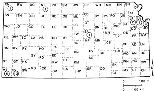
Figure 1-Map showing location of recorded paleoindian sites in Kansas according to county.
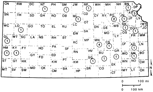
Figure 2--Map showing locations, by county, of recorded paleoindian projectile points (adapted from Yaple, 1968, and Stein, 1984).
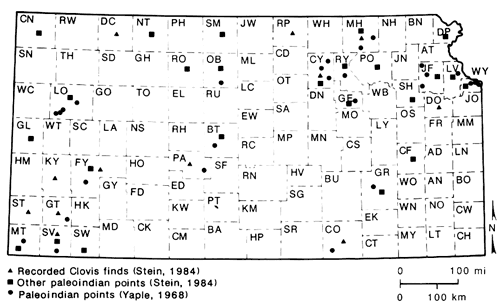
Figure 3--Illustrations of paleoindian projectile points (a-h) and "spurred scraper" (i): a) Clovis, b) Folsom, c) Plainview, d) Agate Basin, e) Firstview, f) Hell Gap, g) San Jon, and h) Meserve/Dalton. (e) and (g) are from Wheat, 1972; (i) is from Frison, 1978.
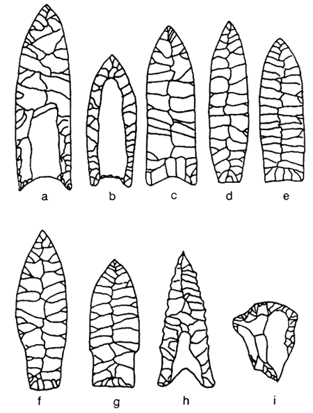
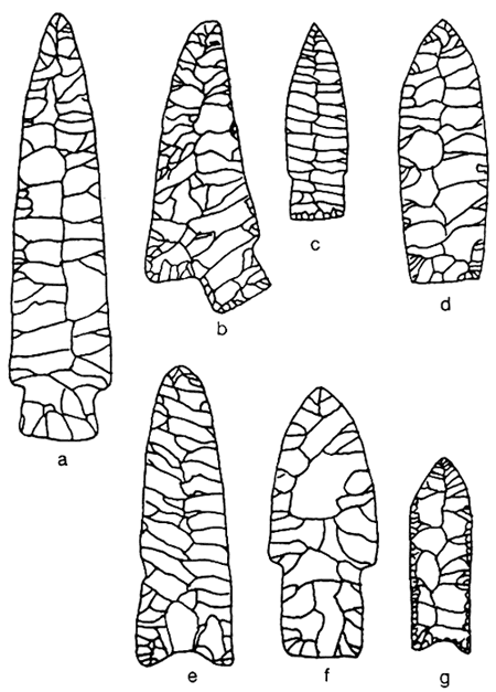
Figure 4--Illustrations of paleoindian projectile points: a) Scottsbluff, b) Cody Knife, c) Eden, d) Milnesand, e) Frederick (Myers, 1977), f) Alberta, and g) Midland. (b) is from Frison, 1978.
The term Llano was originally applied to a complex of artifacts found in direct association with extinct megafauna, especially mammoth, in the southern High Plains (Sellards, 1952). However, Clovis projectile points (fig. 3a), distinctive fluted points diagnostic of this complex, have been found throughout the Great Plains region. Haynes (1970) dates the occurrence of Clovis points between 11,000 and 11,500 yrs B.P. and hypothesizes a "population explosion" keyed to the Two Creeks deglaciation of North America in order to account for the sudden appearance of the Llano complex. The Llano complex in Kansas is known only from surface finds of Clovis points (fig. 5). At present, no sites of this paleoindian complex in Kansas have been excavated and no evidence has been found at any of the known localities of a direct association between Clovis points and extinct fauna.
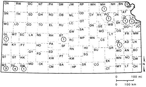
The Folsom complex was first recognized in 1926 during the excavation of a bison-kill site near Folsom, New Mexico, by paleontologists from the Colorado Museum of Natural History. The bison remains were identified as Bison antiquus (Figgins, 1927). The discovery of 19 fluted projectile points in direct association with the bison bones provided the earliest "accepted" evidence for the contemporaneity of humans and Pleistocene fauna in North America. The Folsom complex is radiocarbon dated from about 10,200 to 10,850 yrs B.P. (Frison, 1978, p. 23; Frison and Zeimens, 1980, p. 231). Technologically, the Folsom point (fig. 3b) developed from the earlier Clovis-point form. Folsom points are distributed throughout the High Plains region and have been reported as far east as northeastern Kansas (Wedel, 1959, p. 537) and Missouri (Chapman, 1975, p. 60-94). Surface finds of Folsom points occur throughout Kansas (Yaple 1968; Glover 1978; Stein 1984; fig. 6).
Figure 5--Locations of Clovis projectile-point finds.
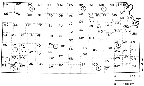
Figure 6--Locations of Folsom projectile-point finds.
Although the Folsom site in New Mexico was the first "accepted" evidence for the presence of humans in North America during the late Pleistocene, the first discovery by professionals of a human artifact in direct association with extinct mammals on this continent occurred in Kansas, at the 12 Mile Creek site (14LO1), in 1895. The 12 Mile Creek site, located along a small tributary of the Smoky Hill River, was excavated by H. T. Martin and T. R. Overton of the University of Kansas Paleontology Department (Williston, 1902, 1905; Sellards, 1947, p. 965). During excavation of fossil bison that were eroding out of a cut-bank, a projectile point was found beneath a scapula. At that time, however, the clear association of an artifact with late Pleistocene fauna did not have any effect on the anthropological community (Rogers, 1984, p. 76-78; Rogers and Martin, 1984). A recent revision of data from the site included two radiocarbon-age determinations of a bison tibia. The apatite fraction was dated to 10,435±260 yrs B.P. (GX-5812-A) after being C-13 corrected and the bone-gelatin fraction was dated to 10,245±335 yrs B.P. (Rogers and Martin, 1984, p. 758).
The projectile point recovered from the 12 Mile Creek site was stolen shortly after its discovery. Its typological identification has been based on a photograph and crude drawings of the find. On the basis of a review of the photograph, Rogers (1984) and Rogers and Martin (1984, p. 781) classify it as a Clovis point. Given the radiocarbon dates from the associated bison bone, however, such an identification is not consistent with the temporal range of the Llano complex. Moreover, its identification as Clovis from the photograph is debatable because the presence of a flute is not clear. Regarding the projectile point as it appears in this photograph (Williston, 1905, p. 336), Wedel (1959, p. 89) has stated that
it appears to have had a relatively short broad outline, with convex edges and slightly concave base; there are no shoulders nor is there definite fluting of the faces. There is nothing outstanding in the chipping and workmanship. It does not conform closely to any of the recognized early Plains types, such as Folsom fluted, Clovis, San Jon, Eden, Scottsbluff, Plainview, etc. although Howard (1935, p. 144) thought it resembled "a rather crude type of Folsom-like point..."
Rogers and Martin (1984, p. 761), however, state "the photograph shows a projectile point with a concave base, a flute, and a somewhat asymmetrical point with an indentation on one side of the tip." They go on to say "the radiocarbon dates of this bison kill are somewhat surprising because they suggest that Clovis projectile points were being used at a time period when one would expect to find Folsom projectile points" (Rogers and Martin, 1984, p. 761). The 12 Mile Creek site, where a single projectile point of no definite typological identity was found in association with the remains of an extinct form of bison, cannot be satisfactorily assigned to the Llano complex. A more supportable interpretation, one consistent with the radiocarbon dates, the faunal association, and the presently accepted range of the Llano, Folsom, and Plano complexes, is that the 12 Mile Creek site is a Folsom or transitional Folsom/Plano site.
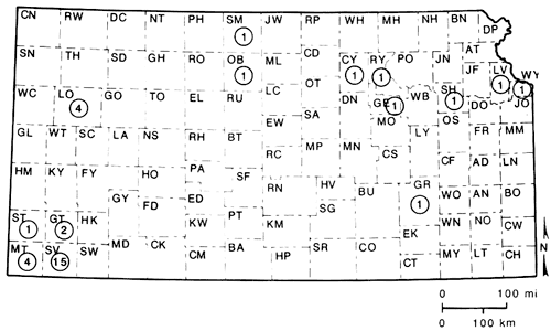
Paleoindian complexes, collectively referred to as Plano, that temporally overlapped and succeeded the Folsom complex are characterized by a variety of chipped stone projectile point and knife forms with parallel flaking and the absence of fluting (figs. 3c-g, 4). Named projectile-point forms that are attributed to Plano complexes and that have been reported in Kansas include Plainview, Hell Gap, Meserve/Dalton, Milnesand, Midland, Agate Basin, Scottsbluff, and Eden (table 2, figs. 7-9). Most of the Plano point-type designations refer to the sites in the High Plains region at which they were first discovered. These sites generally consist of large mammal-kill and butchering sites. Because of the paucity of information regarding the Plano sites in Kansas, almost all the information concerning them must come from other areas of the High Plains. The following summaries of Plano complexes are primarily from Frison (1978, p. 31-40, 1983, p. 109-124).
Figure 7--Locations of Plano projectile-point finds.
The Agate Basin complex is radiocarbon dated between 10,500 and 10,000 yrs B.P. The best sequences for this complex are provided by the Hell Gap and Brewster sites in Wyoming. The characteristic artifact of the complex is the Agate Basin point (fig. 3d). The complex is restricted to the northern and northwestern part of the Central Plains (Frison, 1978, 1983).
The Plainview complex is radiocarbon dated between approximately 11,000 to 10,000 yrs B.P., or contemporaneous with the Agate Basin complex. The Plainview complex, however, occurs in the Central and Southern plains. The characteristic point of this complex is the Plainview point (fig. 3c). Technologically, a direct relationship may exist between Plainview and Folsom points. The best sequence for the Plainview complex is at the Lubbock Lake site in Texas (Johnson and Holliday, 1980; Frison, 1983, p. 114). Figure 8 presents the distribution of Plainview points in Kansas.
Figure 8--Locations of Plainview projectile-point finds.
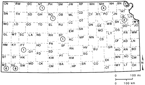
Table 2--Frequencies of reported paleoindian projectile points in Kansas by county.
| Clovis | Folsom | Plainview | Plano | Hell Gap | Meserve/Dalton | |||||||||||
|---|---|---|---|---|---|---|---|---|---|---|---|---|---|---|---|---|
| Clay | 1 | Barton | 1 | Barton | 1 | Clay | 1 | Cheyenne | 1 | Jefferson | 2 | |||||
| Coffey | 1? | Coffey | 1 | Doniphan | 1 | Geary | 1 | Norton | 1 | Leavenworth | 1 | |||||
| Cowley | 1 | Doniphan | 1 | Finney | 1 | Grant | 2 | Saline | 1 | Stevens | 5 | |||||
| Decatur | 1 | Greeley | 1? | Jefferson | 1 | Greenwood | 1 | Wyandotte | 1 | Wyandotte | 7 | |||||
| Doniphan | 1 | Jefferson | 1 | Marshall | 1 | Leavenworth | 1 | |||||||||
| Douglas | 1 | Leavenworth | 1 | Norton | 1 | Logan | 4 | |||||||||
| Finney | 1 | Marshall | 1 | Rooks | 1 | Morton | 4 | |||||||||
| Grant | 1? | Morton | 3 | Stevens | 8 | Osborne | 1 | |||||||||
| Kearny | 1 | Pottawatomie | 1 | Morton | 6 | Riley | 1 | |||||||||
| Marshall | 1 | Seward | 1 | Leavenworth | 1 | Shawnee | 1 | |||||||||
| Pawnee | 1 | Stevens | 4 | Smith | 1 | |||||||||||
| Stanton | 1? | Stanton | 1 | |||||||||||||
| Stevens | 8+1? | Stevens | 15 | |||||||||||||
| Republic | 2 | Wyandotte | 1 | |||||||||||||
| Wyandotte | 1 | |||||||||||||||
| Agate Basin | Scottsbluff | Midland | Eden | Milnesand | |||||||||
|---|---|---|---|---|---|---|---|---|---|---|---|---|---|
| Morton | 4 | Morton | 1 | Stevens | 1 | Morton | 1 | Stevens | 1 | ||||
| Stevens | 1 | Stevens | 4 | Wyandotte | 1 | ||||||||
The Hell Gap complex is radiocarbon dated between 10,000 and 9,600 yrs B.P. The best sequences for this complex are the Casper, Agate Basin, Sister's Hill, Carter/Kerr-McGee, and Jones-Miller sites of the High Plains (Frison, 1978, 1983). The Jones-Miller site is nearest to Kansas, located in northeast Colorado near the town of Wray. The characteristic artifact of the Hell Gap complex is the Hell Gap point (fig. 3f). Technologically, the Hell Gap point may be derived from the Agate Basin point type.
Figure 9--Locations of Hell Gap, Meserve/Dalton, Agate Basin, Scottsbluff, Midland, Eden, and Milnesand projectile-point finds.
O'Brien (1984) reports a Hell Gap quarry site in Norton County, northwest Kansas. This site, the Tim Adrian site (14NT604), is unique because it is believed to represent a quarry and associated workshop. All other reported Hell Gap sites are associated with mass bison kills and butchering activities. Test excavations were conducted at the Tim Adrian site in 1981 by personnel from Kansas State University (O'Brien, 1984). Recovered cultural remains included "spurred" endscrapers (fig. 3i), bifaces, choppers, cores, and the base of a Hell Gap point. This material was confined to the upper 10 cm of the site area and had been subject to agricultural disturbance. The Tim Adrian site is noteworthy, however, because it represents a different activity from that most commonly associated with other Hell Gap sites and provides information on the lithic-procurement aspect of paleoindian lifeways. This site is one of only three late paleoindian or transitional paleoindian/Early Archaic sites in Kansas to have been excavated or tested.
The Meserve/Dalton complex is radiocarbon dated between 10,000 and 9,000 yrs B.P. Myers and Lambert (1983) suggest that the Meserve biface, a late paleoindian-Early Archaic point commonly found in the mixed- and short-grass prairie-plains of Nebraska and Kansas, is conspecific with similar Dalton points of the eastern deciduous woodland. On the basis of that identification, they hypothesize that peoples with a Dalton point-reduction technology exploited the oak-hickory gallery forests that threaded the Central Plains. They suggest that the Meserve/Dalton folk of the Central Plains were a clinal variant of the more broadly dispersed Dalton culture complex and that their settlement-subsistence practices were probably characterized by a greater reliance on both woodland and prairie resources than those of the Dalton folk. The best sequences for the Dalton complex are from Graham Cave and Arnold Research Cave in eastern Missouri. The combined Meserve/Dalton complex is characterized by the Meserve/ Dalton point or knife (fig. 3h). The complex is widespread and surface finds of Meserve/Dalton points have been reported in Kansas (Reichart, 1974, 1976; Logan, 1981; Rogers and Martin, 1983). Technologically, these points probably developed from preceding fluted-point forms found in the eastern woodlands.
The Cody complex is radiocarbon dated between 8,800 and 8,400 yrs B.P. The best sequences for the complex occur at the Horner, Finley, Medicine Lodge Creek, and Hell Gap sites. The characteristic artifacts of the Cody complex are the Scottsbluff and Eden points and the Cody knife (fig. 4a-c).
Site 14SG516, located near Wichita, may have a Cody complex component. Test excavations indicated the presence of a possible campsite. If the suggested cultural affiliation is correct, this site is noteworthy because it occurs within the southernmost range of the Cody complex and because it is a campsite rather than a "kill site," a site type more commonly associated with the Cody complex. No further investigations which might have supported the suggested cultural identification, however, were conducted at the site (Hovde and Blakeslee, 1977).
The Frederick complex, which is not well defined and has few excavated components, is radiocarbon dated between 8,400 and 8,000 yrs B.P. The best sequence for this complex is at the Hell Gap site. The Frederick complex is characterized by lanceolate projectile points with parallel-oblique pressure flaking and without shoulders and stems (Frison, 1978, 1983; fig. 4e). The occupation at zone III of the Lime Creek site in southwestern Nebraska is assigned to the Frederick complex by Wheat (1972, p. 144). A Frederick point has been recovered from the Republican River in south-central Nebraska (Myers, 1977).
The Sutter site (14JN309), located on the west fork of Muddy Creek in Jackson County, Kansas, is believed to have a Frederick component. Salvage archeological investigations at this site, buried below some 30 ft (9 m) of deposits, resulted in recovery of lanceolate and square-stemmed projectile points, blades, and a large scraper that Katz (1971) suggests compare favorably to the Frederick and McKean complexes of the northwestern Plains. Three accepted radiocarbon dates from the site place the occupation of the Sutter site at 7,990±245 to 7,668±237 yrs B.P. (Katz, 1972). Katz (1971, p. 17) interprets this site as evidence that its hunter-gatherer occupants procured modern bison that probably became mired in a nearby bog on the valley floor and then processed them in the immediate vicinity of the kill. The presence of a fire area, consisting of charcoal and burned earth, suggests consumption of the game at the site as well. Two handstones and two grinding slabs were recovered and these are interpreted as evidence that plant-food processing also occurred. The quantity of lithic artifacts and animal remains indicated "intensive or lengthy activity in the valley" (Katz, 1971, p. 17). The radiocarbon dates, associated modern fauna, and evidence for plant-food processing suggest this site is transitional from a paleoindian to an Archaic form of adaptation in north-central Kansas between 7,500 and 8,000 yrs ago. The deep burial of the cultural material from the Sutter site suggests other sites of that age in alluvial settings in the Central Plains may occur in similar geomorphic contexts.
Soil complexes, as defined by the Soil Conservation Service, for the 27 recorded paleoindian sites of Kansas are shown in table 1. Site frequencies and relative percentages of sites and their soil associations are shown in table 3. Frequencies of sites and their topographic contexts also are shown in table 3. Because of the low site frequencies, no detailed inferences or conclusions can be obtained from the soil complex and topographic associations. However, a few general trends are observable in the data. Concerning soil associations, paleoindian sites are most frequently found associated with the Verdigris, Wells, Harney, Holdredge, and Kennebec soil complexes. Recorded paleoindian sites are most frequently associated with terraces. Examination of both the soil and topographic data indicates over 60% of the recorded paleoindian sites are associated with river and stream valleys. This suggests two possibilities: I) a bias has been towards surveys of river valleys and subsequent site-locational information is, therefore, also biased, or 2) the present site-locational data are representative of reality and few paleoindian sites are located on bluff slopes, bluff tops, and the uplands. Because of the small sample size, no definitive conclusions can be made; however, the former situation is believed likely. That is, a bias exists in present survey methods toward river valleys. Paleoindian sites are likely to occur in high frequencies in other topographic contexts. In addition, recorded paleoindian sites are biased toward the eastern part of the state (fig. 1).
Table 3--Paleoindian sites and associated topographic areas and soil complexes.
| Sites and Topographic Content | |||||||
|---|---|---|---|---|---|---|---|
| Unknown | Terrace | Uplands | Stream Bank |
Bluff Top |
Alluvium | Bluff Slope |
Gravel Pit |
| 5 | 15 | 2 | 1 | 1 | 1 | 1 | 1 |
| 18.5% | 55.6% | 7.4% | 3.7% | 3.7% | 3.7% | 3.7% | 3.7% |
| Sites and Associated Soil Complexes | ||
|---|---|---|
| Soil Complexes | Number of sites | Percentage |
| active dunes | 1 | 2.4 |
| alluvial lands | 2 | 4.8 |
| broken alluvial lands | 2 | 4.8 |
| Chase | 1 | 2.4 |
| Clime | 1 | 2.4 |
| Goshen | 1 | 2.4 |
| Harny | 3 | 7.1 |
| Holdredge | 3 | 7.1 |
| Irwin | 1 | 2.4 |
| Kennebec | 4 | 9.4 |
| Marshall | 1 | 2.4 |
| Martin | 1 | 2.4 |
| Mason | 1 | 2.4 |
| Morrill | 1 | 2.4 |
| Nuckolls | 1 | 2.4 |
| Olpe | 1 | 2.4 |
| Osage | 1 | 2.4 |
| Richfield | 1 | 2.4 |
| Shelby | 1 | 2.4 |
| Sogn | 1 | 2.4 |
| Uly | 1 | 2.4 |
| Ulysses | 2 | 4.8 |
| Verdigris | 5 | 11.8 |
| Vinland | 1 | 2.4 |
| Wells | 4 | 9.4 |
| Unknown | 3 | |
Two prior studies have been done regarding the distribution of paleoindian projectile points in Kansas (Yaple, 1968; Stein, 1984). Most of the locations of these reported paleoindian points used in their studies are "isolated finds" and few have been systematically field checked and verified by professional archeologists. Site forms, therefore, have not been recorded for most of these projectile-point finds. Figure 2 is a composite map of projectile-point distributions by Yaple (1968) and Stein (1984).
The recorded-site information files (fig. 1) do not agree, in distribution of paleoindian projectile-point types, with the "surface finds" reported in the literature (Yaple, 1968; Glover, 1978; Stein, 1984). Table 2 shows a compilation of "surface find" information from the above sources, in addition to others. Figures 5-9 show the distributions of the reported surface finds for each of the major paleoindian projectile-point types. Several trends are apparent. Clovis points tend to be distributed throughout the entire state (fig. 5), with large gaps in the Smoky Hill and Arkansas River drainages. At present, a study of the Arkansas River area is being conducted by the Archeology Laboratory at Wichita State University. This spatial-data gap, therefore, is currently being addressed (Arthur Rohn, personal communication, 1985). The data for their study, however, are not presently available. High expectations are anticipated for the results of their study. Regarding the Smoky Hill River drainage, the lack of reported Clovis points from this region is attributed to the general lack of surveys conducted by professional archeologists. The reconnaissance conducted by Glover (1978) in Morton and Stevens counties indicates the potential for finding local collectors who possess a wide variety of paleoindian projectile-point types.
Folsom projectile points also have been recovered from portions of the entire state (fig. 6). Several "gaps" exist where Folsom points have not been reported and these include the Arkansas, Smoky Hill, Upper Republican, and Solomon River drainages. The distribution for reported "surface finds" of Folsom points also is attributed to the lack of systematic surveys in western Kansas to locate paleoindian sites, with the exception of Glover's (1978) investigation.
The distribution of Plano points in general is presented in fig. 7. As a whole, these points have been reported from most regions of the state. The distribution of Plainview points (fig. 8) is similar to that for Folsom points. The distribution of other paleoindian points that have been reported in Kansas including the Hell Gap, Meserve/Dalton, Milnesand, Midland, Agate Basin, Scottsbluff, and Eden point types, is shown in fig. 9. Most of these point types occur in western Kansas. Notable exceptions include the Meserve/Dalton point type, which, not surprisingly, is more frequently encountered in the tallgrass prairie-deciduous woodland ecotone area in the northeastern part of the state. Meserve/Dalton points have been found in Doniphan (Wedel, 1959, p. 537), Jefferson (Reichart, 1974), and Leavenworth (Logan, 1981) counties.
The discrepancies between the number of recorded paleoindian sites and reported "surface finds" are attributed to several factors. These include, but are not limited to, the greater time depth for these sites that has permitted natural agents to destroy site integrity. Most of the reported "surface finds" are in topographic contexts not conducive to site preservation, such as unstable sand (e.g., the Cimarron River drainage) and river channels. In brief, the distribution of reported "surface finds" shows a greater density and spatial distribution of paleoindian localities in the state than would otherwise be determined by examination of only recorded sites (fig. 1). In situ paleoindian sites are expected to be of low visibility because they are buried in alluvial and loessal deposits.
Given the deep burial of sites dating to the late Pleistocene and early Holocene, such as the Sutter site, and the fact that most of the recorded finds of Paleoindian points have occurred on stream terraces, future archeological surveys aimed, in whole or in part, at the discovery of paleoindian sites must be conducted in tandem with geomorphological investigations that address the age and evolution of the late Pleistocene and Holocene landscape (e.g., Rogers, this volume). For example, current geoarcheological research in the lower Kansas River basin demonstrates the differential effects of fluvial processes in preserving or eroding late Pleistocene-early Holocene deposits and any archeological evidence they may have contained (Logan, 1985; Logan and Johnson, 1986). Paleosols buried beneath the Newman terrace at two localities on the lower Kansas River have been dated by the carbon-14 method at 7,250±115 yrs B.P. (DIC 2946) and 10,430±130 yrs B.P. (BETA 2931), indicating the fill was being deposited during late Pleistocene and early Holocene time (Johnson and Martin, this volume). The presence of at least one buried soil that dates to a time when paleoindian groups occupied the Central Plains indicates some potential for discovering evidence of their activities. It is interesting that the Newman terrace constitutes 50% of the valley floor from the city of Topeka downstream to the village of Eudora and that below Eudora it has been largely destroyed by lateral planation. Along the latter reach, perhaps not entirely by coincidence, sand and gravel bars contain skeletal remains of Rancholabrean fauna, including mammoth, mastodon, musk ox, sloth, peccary, and stag moose (Martinet al., 1979) and the few finds of fluted projectile points that form our only evidence to date of the presence of paleoindians in the Kansas River valley (Rogers and Martin, 1982, 1983). Although not yet demonstrated conclusively, such finds may reflect, in part, the erosion and redeposition of Newman terrace deposits. In this case, geomorphological investigation of the age of the Newman terrace fill and its relative presence or absence in certain areas along the lower Kansas River provides a predictive guide for archeologists who seek the most promising areas of in situ deposits that date to the paleoindian period.
The archeological record of the paleoindian occupation of Kansas as it is presently known is poor. However, the distribution of paleoindian sites and "isolated finds" of diagnostic projectile points throughout the state and with regard to their topographic contexts suggests the record reflects a survey bias and not necessarily the fact that the paleoindian occupation was ephemeral. Moreover, it is becoming increasingly clear that future attempts to correct the survey biases of the past must be carried out in conjunction with geomorphological investigations of the age and evolution of late Pleistocene and Holocene landforms.
Chapman, C. H., 1975, The archeology of Missouri, v. 1: Columbia, University of Missouri Press, 288 p.
Figgins, J.D., 1927, The antiquity of man in America: Natural History, v. 27, no. 3, p. 229-239.
Frison, G. C., 1978, Prehistoric hunters of the High Plains: New York, Academic Press, 457 p.
Frison, G. C., 1983, The western plains and mountain region; in, Early Man in the New World, Richard Shutler, ed.: Beverly Hills, Sage, p. 109-124.
Frison, G. C. and Zeimens, G. M., 1980, Bone projectile points-an addition to the Folsom culture complex: American Antiquity, v. 45, no. 2, p. 231-237.
Glover, G. F., 1978, An analysis of early paleoindian projectile points with new data from southwestern Kansas: M.A. thesis, Wichita State University, Wichita, Kansas.
Haynes, C. V., 1970, Geochronology of man-mammoth sites and their bearing on the origin of the Llano complex; in, Pleistocene and Recent Environments of the Central Great Plains, Wakefield Dort, Jr., and J. K. Jones, Jr., eds.: Lawrence, University Press of Kansas, p. 77-92.
Hovde, David, and Blakeslee, D. J., 1977, Archeological phase n tests at site 1480516--a suspected Cody complex campsite in Sedgwick County, Kansas: M.S. thesis, Department of Anthropology, Wichita State University, Wichita, Kansas.
Johnson, Eileen, and Holliday, V. T., 1980, A Plainview kill/butchering locale on the Llano Estacado-the Lubbock Lake site: Plains Anthropologist, v. 25, no. 88. p. 89-112.
Katz, P. R., 1971, Archaeology of the Sutter site, in northeastern Kansas: Plains Anthropologist, v. 16, no. 51, p. 1-19.
Katz, P. R., 1972, Radiocarbon dates from the Sutter site, northeastern Kansas: Plains Anthropologist, v. 18, p. 167-168.
Logan, Brad, 1981, An archaeological survey of the Stranger Creek drainage system, northeast Kansas: Museum of Anthropology, Project Report Series 48, University of Kansas, Lawrence, 148 p.
Logan, Brad, 1985, O-Keet-Sha culture history and its environmental context, the archaeology of Stranger Creek basin, northeastern Kansas: Ph.D. dissertation, University of Kansas, 434 p.
Logan, Brad, and Johnson, W. C., 1986, Geoarchaeological investigations in the lower Kansas River basin: Current Research in the Pleistocene, v. 3 (in press).
Martin, L. D., Whetstone, K. N., Chorn, J.D., and Frailey, C. D., 1979, Survey of fossil vertebrates from east-central Kansas-Kansas River Bank Stabilization Study; Report submitted to Kansas City District, U.S. Army Corps of Engineers, Kansas City, Missouri: Museum of Natural History, University of Kansas, Lawrence.
Myers, T. P., 1977, Manmade artifacts from the Red Willow gravel pits: Transaction of the Nebraska Academy of Sciences, v. 4, p. 9-12.
Myers. T. P., and Lambert, Ray, 1983, Meserve points--evidence of a Plainsward extension of the Dalton horizon: Plains Anthropologist, v. 28, no. 99, p. 109-114.
O'Brien, P. J., 1984, The Tim Adrian site (14NT604)--a Hell Gap quarry site in Norton County, Kansas: Plains Anthropologist, v. 29, no. 103, p. 41-56.
Reichart, Milton, 1974, A Meserve point from northeastern Kansas: Kansas Anthropological Association Newsletter, v. 19, no. 7-8, p. 1-3.
Reichart, Milton, 1976, The archeological resources of Cedar Creek--a site survey in Jefferson and Jackson counties of northeast Kansas: Kansas Anthropological Association Newsletter, v. 21, no. 5-6, p. 3-40.
Rogers, R. A., 1984, Kansas prehistory--an alluvial geomorphological perspective: Ph.D. dissertation, University of Kansas, Lawrence, 321 p.
Rogers, R. A., and Martin, L. D., 1982, A Clovis point from the Kansas River: Transactions of the Kansas Academy of Sciences, v. 85, no. 2, p. 78-81.
Rogers, R. A., and Martin, L. D., 1983, American Indian artifacts from the Kansas River: Transactions of the Nebraska Academy of Sciences, v. 11, p. 13-18.
Rogers, R. A., and Martin, L. D., 1984, The 12 Mile Creek site--a reinvestigation: American Antiquity, v. 49, no. 4, p. 757-764.
Sellards, E. H., 1947, Early man in America--index to localities and selected bibliography, 1940-45: Geological Society of America, Bulletin, v. 58, p. 955-978.
Sellards, E. H., 1952, Early man in America--a study in prehistory: New York, Greenwood.
Stein, Martin, 1984, Traces of early man in Kansas tantalize archeologists: Kansas Preservation, v. 6, no. 2, p. 5-7.
Wedel, W. R., 1959, An introduction to Kansas archeology: Smithsonian Institution, Bureau of American Ethnology, Bulletin 174, 723 p.
Wheat, J. B., 1972, The Olsen-Chubbuck site--a paleoindian bison kill: American Antiquity, Memoir 26, 180 p.
Williston, S. W., 1902, An arrow-head found with bones of Bison occidentalis Lucas, in western Kansas: American Geologist, v. 30. no. 5, p. 313-315.
Williston, S. W., 1905, On the occurrence of an arrow-head with bones of an extinct bison: Proceedings of the International Congress of Americanists, 13th Session, p. 335-337.
Yaple, D. D., 1968, Preliminary research on the paleoindian occupation of Kansas: Kansas Anthropological Association, Newsletter, v. 13, no. 7, p. 1-9.
Prev--Grass-opal phytoliths as climatic indicators || Next--Paleoindian sites in the Neosho River drainage
Kansas Geological Survey
Comments to webadmin@kgs.ku.edu
Web version updated April 7, 2010. Original publication date 1987.
URL=http://www.kgs.ku.edu/Publications/Bulletins/GB5/Brown/index.html