![]()
Prev Page--More on Ground Water Next Page--Quaternary System
Geologic Formations and their Water-bearing Properties
The geologic summary of the Mesozoic water-bearing formations in Republic County and northern Cloud County has been adapted largely from Wing (1930), and the geology of the Quaternary deposits is discussed by S. W. Lohman.
Paleozoic Rocks
Information regarding the Permian and older rocks beneath the surface in Republic and Cloud counties is based on the records of deep tests for oil and gas and on the exposures of these rocks about 20 miles east of Republic County. The records of a few deep tests for oil and gas indicate that about 900 to 1,300 feet of rocks of Permian age underly the Cretaceous rocks in this area. Permian rocks were penetrated at a depth of about 150 feet in the Danelson well in sec. 1, T. 5 S., R. 1 W. They were reached at a depth of about 300 feet in the Walker well in sec. 23, T. 2 S., R. 1 W. and in the Kouba well in sec. 24, T. 4 S., R. 2 W.
The Permian rocks are underlain by about 900 to 1,400 feet of rocks of Pennsylvanian age. The following groups of the Pennsylvanian rocks were tentatively identified by Wing as being represented in this area--Wabaunsee, Shawnee, Douglas, Kansas City, Lansing, Marmaton, and Cherokee.
No wells are known to obtain water supplies from these rocks in Republic and Cloud counties. It is probable that any water encountered would be salty and highly mineralized.
Cretaceous System
The Cretaceous rocks that are represented in Republic County and northern Cloud County are the Dakota formation consisting of sandstone and shale, the Graneros shale, the Greenhorn limestone consisting of alternate beds of limestone and shale, and the Carlile shale.
Gulfian Series
Dakota Formation
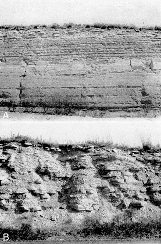
Character--The strata of the Dakota formation consist of lenticular beds of quartz sandstone and beds of variegated shale, clay, and siltstone. The beds of sandstone are fine- to medium-grained, range in color through gray, yellow, buff, brown, and reddish brown, and generally are cross-bedded. Because the sandstone beds of the Dakota are exposed prominently in many places, the formation is generally thought to be composed almost entirely of sandstone (Pl. 3Ar Wing (1930, pp. 31-33) stated:
In general three sandstones can be recognized which, with the intervening shales, constitute five divisions in all. The lowest sandstone crops out in the extreme southeastern comer of Cloud County, where its maximum thickness is approximately 100 feet. Its upper few feet may be seen in the creeks near Miltonvale, while almost its entire thickness is exposed in the creek valley three miles south and a mile east; . . .
The next overlying member is composed of mottled clay shale. It is approximately 100 feet thick and is overlaid in turn by the 2O-40-foot intermediate sandstone. The latter outcrops at the top of the hills two miles northeast of Miltonvale.
The upper shale member is similar to the lower in texture and color. It ranges in thickness from 80 to 100 feet and is overlaid by the upper sandstone member, which is 40 to 80 feet thick. The latter outcrops on the hills southwest of Glasco, on the higher hills between Glasco and Miltonvale and on the bluff south of the river near Concordia. Other prominent outcrops occur on the higher knolls in the southeastern part of Republic County.
In a recent study of the stratigraphy of the Dakota formation Plummer and Romary (1942, pp. 327-328) found that
In some places the coarser sandstone has the appearance of being relatively thin and horizontally persistent. This seems particularly true of sandstone that caps a series of hills. Where such occurrences have been studied in detail, it was found that the capping sandstone occupies different stratigraphic positions, although the dark, case-hardened sandstone on the hill top has the appearance of being thin; horizontally persistent "sheets."
Despite expressed qualifications and warnings, the geologist is prone to fix his eye on resistant beds in a published columnar section. For this reason no channel sandstone is described in the following generalized section of the Dakota formation. Anyone desirous of doing so may insert a lenticular sandstone in any portion of the section and be reasonably assured that such a sandstone occurs at that stratigraphic position somewhere in the area of the outcrop.
| Generalized section of the Dakota formation in north-central Kansas, by N. Plummer and J. F. Romary | Range of thickness in area discussed (feet) | ||
|---|---|---|---|
| Cretaceous--Gulfian | |||
| Graneros shale | |||
| Shale; dark, fissile; contains rusty, yellow to brown partings, selenite crystals, and, locally, channel sandstones; marine fossils present. | 21.0 to 40.0 | ||
| Dakota formation | |||
| Janssen clay member | |||
| 17. Limonite, siderite, or hematite, concretionary, associated with some silt or fine sand; may be a difficultly discernible bed, or a part of a transitional bed grading from typical Dakota to typical Graneros. | 01.1 to 5.0 | ||
| 16. Siltstone, gray to light gray, commonly fairly resistant; contains fragments of lignitized wood, some fossil leaves, and small vertical channels, some of which look like worm borings and others like molds of sterns or roots. This zone generally contains much limonite or siderite, and, in a few cases, lignitized stems or roots. In some small areas a channel sandstone occupies this horizon. | 0.5 to 4.0 | ||
| 15. Lignite and black lignitic clay; this bed may be massive or shaly. | 0.1 to 4.0 | ||
| 14. Clay, silty, gray, plastic, and some silt; typically medium gray in color; contains lignite particles and an abundance of fossil leaves. Locally, this zone is occupied by rather uniform dark to medium gray silty shale. All samples taken from this bed are fire clays. | 15.0 to 30.0 | ||
| 13. Clay, mottled, gray and light red, lithologically similar to overlying bed except for greater percentage of ferric iron. This bed is missing is many places, or, locally, it is lenticular. | 0.0 to 10.0 | ||
| 12. Clay, silty to plastic, gray, stained yellow or orange yellow, especially on and adjoining irregular oblique joints. The clay is massive and breaks with a conchoidal fracture. One or two zones of limonite or siderite pellets are commonly found in this clay | 15.0 to 30.0 | ||
| Terra Cotta clay member | |||
| 11. Clay or silt containing an abundance of concretionary iron in the form of siderite, limonite or hematite "shot." The iron is sufficiently concentrated in many places to form a resistant bed. | 0.1 to 4.0 | ||
| 10. Clay, massive, locally silty; this zone may or may not be stained yellow or mottled red. | 0.0 to 10.0 | ||
| 9. Silt and sandstone, very fine, gray or yellow, generally thin-bedded and containing lignite particles. In many places this bed is "quartzitic," or contains' ellipsoidal concretions of "quartzite," but it may be missing entirely, bed no. 11 of the Janssen member occurring immediately above it. | 0.0 to 10.0 | ||
| 8. Clay, massive, gray, of fire-clay type; commonly contains some fossil leaves and lignite particles. | 1.0 to 5.0 | ||
| 7. Clay, massive, lignitic, dark gray; contains fossil leaves | 0.1 to 3.0 | ||
| 6. Clay, mottled gray and red; massive, of the fire-Clay type obliquely jointed irregularly and breaking out with a conchoidal fracture. This zone contains economically important beds of gray fire clay having a high alumina and low iron content. Some seemingly persistent zones of concretionary iron in the form of limonite, siderite, or hematite pellets, or of: granular hematite; occur-in this division. There are also some thin beds of sandstone and silt, not channels or bars, in which "quartzite" concretions are commonly found. | 100.0 to 150.0 | ||
| 5. Clay to clayey silt, mottled gray, red, and yellow, having an abundance of limonite, siderite, or hematite pellets, or granular hematite; the granular hematite is most common. | 1.0 to 6.0 | ||
| 4. Clay, mottled light gray and red, kalolinitic, gradational contact at top and bottom. | 1.0 to 5.0 | ||
| 3. Kaolin, white; does not slake readily, and appears as a band of white fragments on weathered surface. At some places this bed is not evident on exposures, but generally it can be identified by ceramic tests and chemical analyses. | 0.1 to 1.5 | ||
| 2. Clay with silt, gray to dark gray, or fine sandstone bands, lignite and fossil leaves common. In some sections portions of this bed are shale or thin-bedded clay. A highly lignitic, darker band commonly occurs toward the bottom, and pyrite, also. This bed is mostly a refractory fire clay; and unless yellow stain is marked, samples fire to ivory or cream colors. | 5.0 to 30.0 | ||
| 1. Siltstone and fine sandstone, mostly thin-bedded, but locally cross-bedded; this zone characteristically contains "quartzite" concretions, which, if not quartzitic, are likely to be very friable. Fossil leaves, fragments of lignite, and nodules are common. This zone is missing in places, in which case Dakota' clay (bed 2) rests directly on Kiowa shale or older rocks. | up to 20.0 | ||
Black lignite has been found in the Dakota formation and is mined near Minersville between Belleville and Concordia. The lignite is described by Wing as consisting of two layers, an upper layer about 8 inches thick and a lower layer about 12 inches thick, which are separated by as much as 4 inches of "black jack," or impure coal. The upper layer contains more sulfur and burns more quickly than the lower layer.
Distribution and Thickness--The Dakota formation, which is the oldest formation exposed in the two counties, crops out in the southeastern part of Republic County and adjacent Cloud County, along some small creeks near the middle of the eastern part of Republic County, and along the Republican River Valley throughout its course in Cloud County. So far as is known the Dakota formation is present at or below surface everywhere in Republic County and northern Cloud County. It was encountered by the municipal wells at Cuba and Narka and the abandoned municipal wells at Belleville. Many wells in the southwest quarter of Republic County terminated in the Dakota formation.
According to Wing nearly 400 feet of the Dakota formation crops out in Cloud and Republic counties. The Walker oil-test well in sec. 23, T. 2 S., R. 1 W. penetrated about 300 feet of the formation. The Danelson oil-test well in the northeastern corner of Cloud County penetrated only about 125 feet of the formation, the upper part of the formation having been removed by erosion.
Water supply--The Dakota formation is an important water-bearing formation in several other states and is a notable source of artesian water. In Republic County and northern Cloud County it is also an important water-bearing formation but in parts of the area the water is of very poor quality and unsuitable for stock and domestic use. The water generally is under some artesian head, but in most places the head is not sufficient to produce flowing wells. Logan (1897, p. 213) stated: "In one of the Republic County salt marshes an artesian flow was obtained with sufficient pressure to lift the water 12 feet high."
The Dakota formation in the outcrop area in southeastern Republic and northern Cloud Counties yields an abundant supply of good water for stock and domestic use, but south and west of Talmo the water is too salty for stock use. Several deep' wells between Cuba and Narka obtain water of good quality from the Dakota formation. The analyses of the municipal supplies at Cuba and Narka are given in Table 6. About 5 miles west of Narka the water becomes very salty as indicated by the analyses of waters from wells 16 and 17 given in Table 6. Practically no information is available regarding the quality of water in the Dakota formation where it is overlain by the Belleville formation, as adequate water supplies are obtained from the Belleville formation and wells are not drilled on into the Dakota formation except along the fringe of the Belleville. In the vicinity of Belleville and north and east of Scandia the formation yields highly mineralized water. In the area west of U. S. Highway 81 and south of Scandia it is not possible to predict the quality of water that would be obtained from a well penetrating the Dakota formation. Many wells in the Dakota in this area yield water that is very highly mineralized whereas other wells in the same section may yield good water.
Numerous theories have been advanced to account for the large variance in the mineral content of the well water obtained from the Dakota formation. As the ground water is fresh in the greater part of the outcrop area it seems reasonable to believe that rainfall infiltration over a period of thousands of years has diluted and flushed out much of the salty water leaving water of a much lower mineral content.
Logan (1897, pp. 209-10) suggested that the highly mineralized water may be caused by certain shale horizons, and stated:
Resting upon the lignite is a bed of shales which are, in the majority of instances, highly saliferous in character. They vary in thickness from 15 to 30 feet. By the disintegration of these shales salt marshes have been formed in many localities along the exposure of the upper Dakota horizon. The marshes occur on Marsh Creek in Cloud County; on West Creek, Marsh Creek and Salt Creek in Republic County. The saline properties of the Great Spirit Spring, which is located in an outlier of the Dakota near Cawker City, are due to these shales. Salt springs occur in this horizon in Mitchell, Jewell, and Republic Counties, and the water of the wells which pass through the shales is invariably saline. Above the saliferous shales is a bed of shales varying in thickness from 10 to 20 feet. These shales are thin, laminated and of loose texture. They contain quantities of gypsum crystals.
Wing (1930, p. 49) seemed to agree with Logan concerning the source of the salty water. He stated:
In some of the wells the water contains so much salt, gypsum, and iron that it cannot be used even for watering stock. Whether this condition is a local one with all the principal sandstones in the formation yielding salt water or whether this objectionable water comes only from certain beds cannot be determined from data at hand. It seems to the writer, from experience gained elsewhere and through knowledge of the conditions existing in the Dakota, that the wells yielding fresh water produce from different beds than those in which the water is salty. This offers the hope that fresh water may be produced in any locality from the Dakota if the the driller will very carefully obtain and test unadulterated samples of water from each and properly case off the strata producing salt water. The discovery of fresh-water horizons in localities where the Dakota has heretofore produced only salt water and where water from other sources is insufficient would be of great value.
Graneros Shale
Character--The Graneros shale is a noncalcareous clay shale ranging in color from dark blue to black. It contains numerous lemon-yellow flakes of sandstone and transparent crystals of gypsum. In some places there is a bed of brown sandstone near the middle and thinner rusty-colored lenses both above and below. The shale weathers to a heavy clay which shows numerous desiccation cracks during the dry season.
Distribution and Thickness--The Graneros shale underlies all Republic County except the southeastern part. It underlies only a small area in the northern part of Cloud County. It crops out in small areas along the stream valleys in the southern and eastern parts of Republic County and in the northwestern part of Cloud County (Pl. 1). According to Wing the formation has a thickness of 20 to 30 feet in Republic and Cloud counties, but is thinner to the north and east.
Water supply--No wells are known to derive water supplies from the Graneros shale in Republic and Cloud counties. The shale is relatively impermeable and would yield little or no water to wells.
Greenhorn Limestone
Character--The Greenhorn limestone contains the only limestones cropping out in either Cloud or Republic Counties. These white-layered rocks can be seen around the edges of the hills and in many road cuts. Some beds of the Greenhorn limestone have been extensively quarried and used for fence posts, flagging, and building purposes. The Greenhorn limestone has been studied by Rubey and Bass (1925, pp. 45-51) in Russell County, by Bass (1926, pp. 31-35) in Ellis County, and by Wing (1930, pp. 24-30) in Cloud and Republic counties.
The Greenhorn limestone consists of thin chalky and crystalline limestone and bentonitic clay and an upper series of interbedded chalky shales and chalky limestones capped by the "Fencepost" bed of limestone (Pl. 11). On fresh exposure the beds of limestone and shale are dull gray in color and the bentonitic clays are light pearly gray. Upon weathering the color of the limestone changes to tan, buff, or orange-tan, and the shales weather tan or light gray in the upper part and tan or orange-tan in the lower part.
Plate 11--Greenhorn limestone. A, In NW cor. sec. 21, T. 4 S., R. 3 W. B, 2 miles west of Belleville on north side of U. S. Highway 36.
The Greenhorn limestone was subdivided by Rubey and Bass (1925, p. 45) into four members which from top to bottom are the Pfeifer shale, Jetmore chalk, Hartland shale, and Lincoln limestone members. Wing (1930, p. 24) stated that in Cloud and Republic counties only the upper two were recognized and the lower two were not differentiated. He characterized the subdivisions of the Greenhorn limestone as follows:
| Members of the Greenhorn limestone with characteristics and thickness | Feet | |
|---|---|---|
| Pfeifer shale: | ||
| "Fence post" limestone bed and underlying gray calcareous shale | 15-16 | |
| Jetmore limestone: | ||
| "Shell rock" at top and thin limestone beds below, alternating with gray calcareous shale | 13-14 | |
| Lower Greenhorn undifferentiated: | ||
| Blue-gray, calcareous shale containing thin crystalline limestones, numerous bentonite-clay layers, and a crystalline limestone bed at the base | 45-53 | |
Distribution and Thickness--The Greenhorn limestone is either at the surface or underlies all Republic County except the southeastern part where the Dakota formation crops out. It also underlies or crops out in a large area in the northwestern part of Cloud County (Pl. 1). It crops out along Rose Creek in the northeastern part of Republic County, along Mill Creek in the eastern part of the county, and along all the streams that flow in a southerly direction from the county.
According to Wing the thickness of the Greenhorn limestone in Republic and Cloud counties is about 83 feet, but the entire thickness is not exposed at anyone place. The thickness of each member is given above.
Water supply--Very few wells that receive their entire water supply from the Greenhorn limestone were observed in Republic County or northern Cloud County. A few very shallow dug wells that receive their water supply from seeps issuing just above impervious layers in the formation were observed along hillsides (Pl. 10B) . Such wells might more properly be classed as springs, however. The water-yielding capacity of the formation is low, and very small supplies of comparatively hard water may be expected from wells penetrating this formation.
Carlile Shale
Character--The Carlile shale is the youngest Cretaceous formation exposed in Cloud and Republic counties. Because of its topographic position and its argillaceous character it has been removed by erosion to such an extent that only a thin and badly weathered layer, is present capping the uplands. Generally it is covered by slopewash so that very few exposures may be seen. Wing (1930, p. 22) stated:
To the southwest it has been divided into a lower calcareous phase called the Fairport member and an upper noncalcareous part named the Blue Hills shale member. Although these divisions can be recognized in Republic County the contact between them is not sharp, and consequently the Carlile is not subdivided in this report. . . . It is impossible from the scattered sections taken to give a complete detailed section of the Carlile in Cloud and Republic counties, but the following partial sections show the character of the lower and middle parts of the formation:
| Section of the lower part of the Carlile shale neat the southeast corner of sec. 19, T.2 S., R. 2 W., Republic County. (Wing,* 1930. p. 22) | Feet | Inches | ||
|---|---|---|---|---|
| Carlile shale: | ||||
| 11. Limestone, reddish-buff at top. | 5 | |||
| 10. Shale, blue gray; calcareous. Contains numerous Ostrea shells. | 5 | |||
| 9. Limestone, dark buff. Varies greatly in thickness. Splits into thin layers. | 3-7 | |||
| 8. Shale, light gray. Calcareous. | 6 | |||
| 7. Limestone. Splits into three distinct layers. The two upper layers are separated by an ochre-red seam of clay along which the limestone is reddish-buff in color. Middle layer is more compact than the other two and is slightly banded. Lowermost layer is chalky and weathers rapidly. | 8-9 | |||
| 6. Shale, gray. Calcareous | 2 | 10 | ||
| 5. Limestone, gray. Intermediate 1/4-inch is cross laminated. | 1 | |||
| 4. Shale, gray. Calcareous. | 2 | 6 | ||
| 3. Limestone. Lower part light buff; upper reddish-buff. | 3 1/2-4 | |||
| 2. Shale, calcareous. | 2 | |||
| Greenhorn limestone-Pfeifer shale member: | ||||
| 1. "Fence post" limestone. | 9 | |||
| * Wing gives this location as sec. 20, T. 12 S., R. 2 W. However, since this location (T. 12 S.) is obviously erroneous, the location has been corrected as above. | ||||
| Section of the middle part of the Carlile shale exposed along bluff in the SW of sec. 2, T. 2 S., R. 5 W., Republic County. (Wing, 1930, p. 23) | Feet | Inches |
|---|---|---|
| 14. Clay, sand and gravel belonging to the Tertiary | 10-12 | |
| 13. Shale, blue-gray. Contains lemon-yellow flakes and fragments of large-shelled Inoceramus | 23 | |
| 12. Bentonite, thin white | 1/2 | |
| 11. Shale, blue-gray. Contains numerous fragments of large-shelled Inoceramus | 10 | |
| 10. Clay, brown, containing thin flakes and small crystals of gypsum. Has bentonitic seam at center | 2 | |
| 9. Shale, blue | 5 | |
| 8. Gray limestone bed containing many small shells of Inoceramus. At the top of this is a zone containing small brownish concretions 1 to 4 inches in diameter | 4 | |
| 7. Shale, blue | 5 | |
| 6. Clay, similar to No. 10 | 3 | |
| 5. Shale, blue papery; containing numerous fragments of large Inoceramus shell and Ostrea | 2 | |
| 4. Clay, similar to No. 10 | 3 | |
| 3. Shale, blue | 4 | |
| 2. Clay, brownish | 1 | |
| 1. Shale, blue, papery; contains numerous Ostrea shells | 12 |
Distribution and Thickness--According to Wing the total thickness of the Carlile shale is approximately 280 feet. The upper 100 feet is not exposed in Cloud or Republic Counties, but may be seen under the protecting edge of the Fort Hays limestone member of the Niobrara formation in the bluff across the line in Jewell County, 1 mile southwest of White Rock.
As shown on Plate 1 the Carlile shale caps the uplands in Republic County. between the area mantled by the Belleville formation and the outcrops of the Greenhorn limestone. It underlies the greater part of the Belleville formation.
Water supply--Although many shallow dug wells obtain meager supplies of water from the weathered near-surface part of the shale, it is not considered a good water-bearing formation. One well (191) that receives its entire water supply from the shale below the weathered zone was observed. The owner reported that shale was encountered at a depth of 28 feet and that no water was found above the shale. Too water contained 1,532 parts per million of sulfate and 3,700 parts per million of dissolved solids.
In some parts of Republic County where the farmers must depend on water supplies from wells in the weathered zone of the Carlile shale, the amount of water obtined is inadequate to supply their requirements for stock and domestic use. Just north of Scandia and just south of Courtland the wells yield very meager supplies. Also west of the Republican River Valley and south of U. S. Highway 36 is a strip of land about 1 mile wide parallel to the Republican River Valley where the wells yield little or no water. Many wells are dug into the underlying shale without finding water.
Prev Page--More on Ground Water Next Page--Quaternary System
Kansas Geological Survey, Geohydrology
Placed on web Nov. 8, 2016; originally published May 1948.
Comments to webadmin@kgs.ku.edu
The URL for this page is http://www.kgs.ku.edu/Publications/Bulletins/73/06_form.html