![]()
Prev Page--Introduction || Next Page--Geology
Geography
Topography and Drainage
Republic County lies in the Pliocene-Cretaceous ground-water province of the Great Plains (Meinzer, 1923, p. 310). It has three types of topography: (1) the loess-covered gently sloping plain in the north-central part of the county; (2) the numerous alluvial valleys; and (3) the deeply dissected uplands which are typical of Cretaceous areas and which cover the eastern, southeastern, and southwestern parts of the county.
The highest part of Republic County is along the Nebraska line and has an altitude of about 1,640 feet. The lowest point in the county has an altitude of about 1,320 feet and is about 2.5 miles west of the southeast corner of the county. The maximum relief, therefore, is about 320 feet.
All but the northeastern corner of Republic County is drained by Republican River and its tributaries. The northeastern corner of the county is at the headwaters of Little Blue River which flows into Big Blue River and is a tributary of Kansas River. Republican River enters the county at the northwest corner and after following a southerly course crosses the southern border of the county about 8 miles from the southwest corner of the county. After entering Cloud County its course is to the southeast as far as Concordia and then follows an easterly direction until it leaves the county.
Salt marshes are found northwest of Jamestown in Salt Marsh Creek and in the valley south of Wayne and Talmo. In these localities the valley is exceptionally wide, the valley flat is marshy, and the water is salty, leaving a white coating on the surface during dry periods. The marsh near Jamestown occurs in the Graneros shale, and the one near Wayne is in the Dakota formation.
The marsh near Wayne and Talmo is known as the Tuthill Marsh and for a time it was one of the principal sources of common salt in Kansas. In fact, the first salt manufactured in Kansas was made from the incrustation and from the brine of this marsh (Darton, 1905, p. 389). That this marsh has changed considerably within the last 80 years is shown by a comparison of its present appearance with published descriptions given in earlier years. Mudge (1864, pp. 33-35) described this marsh as follows:
The valley here is wide, gradually rising to the high prairies, so common in that part of the state. The marsh covers nearly one thousand acres, more or less impregnated with saline matter. About one-third is entirely void of vegetation, which the brine will not allow to grow. It is perfectly level, and at the time of our first visit was as white as a wintry snow-field, with a crust of crystallized salt. The marsh is of recent Alluvial formation, composed of sand and loam, from twenty to thirty feet in thickness, brought down by the wash from the high prairies, which rise gradually from three sides. In this alluvium, at various depths, are found the bones of buffalo, deer and antelope, which have probably made this a resort for salt for long ages past, as they are seen to do at the present time.
The incrustation of salt is frequently three-eighths of an inch in thickness. This is scraped up and used in its natural state for salting cattle, etc.; but for domestic purposes it is melted by being mixed with about twenty gallons of water to a bushel of salt, when the mechanical impurities, sand, etc., readily settle. The salt is then returned to a solid state by evaporation. The marsh after scraping, produces a second crop of salt, in from five to seven days of dry weather, and after repeated scrapings during the past three years, yields as full a supply as at first. The brine exists in nearly equal quantities and strength in all parts of the marsh, and can be obtained by boring a few feet, or digging pits. No definite salt spring shows itself at the surface, but the supply must come from numerous points below, though coming from one great central reservoir or salt bed.
According to the observations of Mr. J. G. Tuthill, who lives near, and has made borings in over one-hundred different places to a depth of twenty or thirty feet, there is a very uniform supply and strength of brine. The water preserved for analysis was obtained by me by a boring made at random. It was found at four feet from the surface. The density, by the salometer, was 24° (6.6 Baume or specific gravity of 1.0421), with the thermometer at 60°. This should give a bushel of salt for one hundred and thirty gallons of the water (not counting impurities), which is three times the strength of the ocean. It was taken at our second visit, immediately after a heavy rain, which must have diluted the brine.
Hay inspected this marsh about 25 years later and found that it had changed considerably during the intervening period as indicated by the following account (Hay, 1891, pp. 88-89):
There can be no question as to the accuracy of the description given by Mudge, but in important respects it differs from a description that would be made today. When Professor Mudge was there, there were probably not fifty acres of plowed land within miles of the marsh; now there are hundreds of acres on all its borders. The result is that much of what was salt marsh is now covered with recent alluvia from the cultivated slopes, and areas where the incrusting was probably great are now covered with cat-tails and other marsh plants. Still, several hundred acres are yet sufficiently saline as to be without vegetation, but nowhere was the saline efflorescence at the time of our visit (September, 1890), so much as one-eighth of an inch in thickness. We digged six feet to get water, though it should be remarked that this is a dry year, and when found the strength by the salometer was 13° with the thermometer at 70°. This would, when corrected to 60° Fahrenheit, give a somewhat higher strength, but still much below that found by Professor Mudge. In the quarter of a century that has elapsed since our old friend visited this marsh, it is safe to say that as a marsh it has diminished in area and its brine is weaker.
There was a well bored some years ago on a piece of land higher than the common level of the marsh, and though this mound is entirely surrounded by the lower level of the marsh, yet the brine in the well always stands at the top, and sometimes flows over the mound. The strength of this by the salometer was 14° with temperature at 66° Fahrenheit. A spring of water at the old Tuthill or Tuttle farm on the east side of the marsh. rises to the same level as the well on the mound. A well bored on the north side of the marsh some twelve years ago, gave stronger brine at sixty feet, but it is now filled up.
Prior to 1942, the lower part of the marsh had been dammed forming a shallow lake which had been stocked with fish. A sample of water collected along the edge of the lake in 1942 had a chloride content of only 690 parts per million. However, this water was greatly diluted by surface inflow.
Population
According to the census of 1940, Republic County had a population of 13,124 and an average density of population of 18.3 inhabitants to the square mile, as compared with 21.9 for the entire state. The census records show a gradual reduction in the population since 1890 of about 100 persons a year. The population of Republic County in 1890 was 19,002; in 1900,18,248; 1910, 17,447; 1920, 15,855; and in 1930, 14,745.
The chief cities and their populations, as reported by the census for 1940, are as follows: Belleville, 2,580; Scandia, 614; Courtland, 383; Republic, 376; Munden, 193; Narka, 193; and Agenda, 179.
Transportation
Republic County and northern Cloud County have exceptionally good transportation facilities. One of the main lines of the Chicago, Rock Island and Pacific Railroad passes through Republic County. The Rock Island Railroad passes through Courtland and Scandia and then divides at Belleville, the northern branch going northeast through Munden and Narka and through Omaha to Chicago, and the southern branch going to Kansas City through Cuba and Clyde. The Missouri Pacific Railroad connects this area with St. Joseph and Kansas City. It passes through Clyde and Concordia and branches at Yuma. The northern branch from Yuma passes through Norway, Scandia, Republic, Warwick, and Superior. The Union Pacific Railroad has a spur line extending from Junction City to Concordia. The Atchison, Topeka and Santa Fe Railway from Emporia to Superior passes through Concordia, Kackley, Courtland, and Lovewell. The Burlington Railroad from Denver to Kansas City passes through Superior, Hardy, and Chester which are on the boundary line between Kansas and Nebraska. A spur from this line passes through Cuba, Wayne, and Concordia.
In addition to the railroads, state and national highways cross Republic County and northern Cloud County from north to south and from east to west and offer easy access to the area by automobile from all directions. U. S. Highway 81 through Concordia and Belleville is one of the important north-south routes across the country, connecting Winnipeg, Canada, with Laredo, Texas on the Mexican border. U. S. Highway 36 runs through Belleville, Scandia, and Courtland. State Highways 9 and 28 connect. Concordia with Clyde and other cities to the east and with Jamestown, Beloit, and other cities to the west. Many of the county roads are graveled and are kept in good condition throughout the year and most of the township roads have been graded.
Agriculture
Agriculture is the chief occupation in Republic County. Wheat, corn, sorghums, and oats are the principal crops grown. A considerable number of cattle and hogs are raised. In the Republican Valley the principal crops are corn, alfalfa, and sorghums. Some irrigation from wells and from the river is practiced in the valley.
Republic County has a total of 460,160 acres. In 1939 the average size of the 2,209 farms in the county was 199.0 acres. The principal crops or usage of farmed land in 1939 in percentage of the total farmed acreage are given in Table 1.
Table 1--Crops and usage of land in Republic County in 1939, in percentage of total acreage.
| Usage of Land | Percentage |
|---|---|
| Cropland harvested | 64 |
| Cropland failure | 3 |
| Cropland idle or fallow | 2 |
| Plowable pasture | 5 |
| Woodland | 1 |
| All other land | 25 |
| Crop | Percentage |
| Wheat | 27 |
| Corn | 19 |
| Sorghums | 4 |
| Oats | 4 |
| Alfalfa | 1 |
| All other crops | 9 |
The soils of Republic County have been described by Throckmorton and others (1937, p. 172) as follows:
The soils of Republic County have been formed from a variety of materials. Most of those in the northern part have been formed from the weathering of wind-deposited materials which formed a mantle or covering over the underlying soils in that part of the county. Those in the extreme southeastern corner have been formed from the weathering of Dakota sandstone, while most of the soils in the remainder of the county have been formed from the weathering of soft limestone and calcareous shales. The soils as a group are dark brown to almost black silt loams to silty clay loams underlain by relatively heavy silty clay loam to clay subsoils and become lighter in color with increase in depth. On the more level areas the upper subsoils are of the consistency of claypan. The soils along the streams vary from sands to clays and from light gray to almost black in color. The soils of Republic County contain sufficient quantities of nutrients to meet the requirements of farm crops.
Natural Resources and Industries
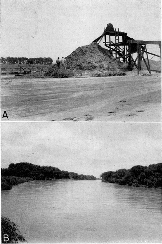
The mineral resources of economic importance in Republic County are gravel and sand, building stone, coal, and clay. Sand and gravel deposits are abundant along Republican River, both in the present stream bed and in low terraces near the margin of the present flood plain. These materials are also abundant in the Pleistocene deposits in the north-central part of the county (Pl. 4A). Sand and gravel are excavated extensively by shovels or by centrifugal pumps at many different points.
Plate 4--A, Sand and gravel pit in Belleville formation northeast of Republic City in sec. 20, T. 1 S., R. 4 W. B, Republican River at relatively high stage on June 14, 1942. View looking north from bridge west of Norway.
The Greenhorn limestone, which crops out extensively in Republic County, is used as building stone. The "Fencepost limestone," which is at the top of the Greenhorn, is quarried at many places in the county. Quarrying is commonly done along the line of outcrop, where the overburden is thin and the rock not badly weathered. The bed ranges in thickness from 6 to 9 inches and is moderately fine and chalky in texture. It is soft enough to permit considerable ease in quarrying, but hardens on exposure. It can always be identified at its outcrop or in a building or fence by its light creamy buff color, which grades into a darker buff band near the center.
Production of coal was begun at Minersville on the border between Republic and Cloud counties as early as 1855 and was continued until relatively recent times when cheaper transportation brought insurmountable competition from eastern Kansas fields. The peak of production was reached in 1894 and 1895 when at least eight companies were operating in the field. Production for Cloud County reached 5,000 tons in 1895 and 8,242 tons for Republic County in 1894 (Wing, 1930, pp. 43-44).
The mines ranged in depth from 30 to 110 feet. The deeper mines began near the base of the Jetmore chalk member of the Greenhorn limestone and passed through approximately 90 feet of blue shale belonging to the lower part of the Greenhorn and to the Graneros shale. The coal occurs approximately 12 feet below the top of the upper sandstone of the Dakota formation (Wing, 1930, p. 44).
Samples of clays in the Dakota formation in the southeastern part of Republic County were collected in 1939 and 1940 by Plummer and Romary (1942) in connection with an extensive study of the ceramic possibilities of Kansas clays. The ceramic properties of the clay will be given in a subsequent bulletin of the Kansas Geological Survey.
Climate
The U. S. Weather Bureau maintained a precipitation gage at the City of Republic from 1902 to 1934 and has maintained a precipitation gage at Belleville since 1934. The distribution of the normal annual precipitation at Belleville, which is 26.52 inches, by months is given in Table 2.
Table 2--Average monthly precipitation at Belleville
| Month | Precipitation, inches |
|---|---|
| January | 0.53 |
| February | 0.94 |
| March | 1.16 |
| April | 2.40 |
| May | 4.00 |
| June | 4.22 |
| July | 3.26 |
| August | 3.20 |
| September | 2.85 |
| October | 1.77 |
| November | 1.20 |
| December | 0.75 |
| Annual | 26.52 |
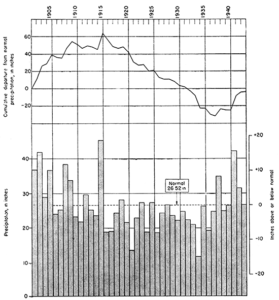
About 78 percent of the precipitation falls during the six-month period from April 1 through September 30, which is favorable for growing crops. The annual precipitation and the cumulative departure from normal precipitation for the stations at Republic and Belleville for the period of record beginning in 1902 are shown graphically in Figure 2. The precipitation has ranged from 11.79 inches in 1934 to 45.20 inches in 1915.
Figure 2--Annual precipitation and cumulative departure from normal precipitation at Republic and Belleville, Kansas. (Data from U. S. Weather Bureau.)
The U. S. Weather Bureau has maintained a precipitation gage at Concordia since 1885. The normal annual precipitation recorded at Concordia is 25.24 inches. The annual precipitation and the cumulative departure from normal precipitation at Concordia for the period of record beginning in 1885 are shown graphically in Figure 3. The precipitation has ranged from 15.28 inches in 1934 to 41.88 inches in 1908. The average precipitation and average departure from normal precipitation for 10-year periods are given in Table 3.
Figure 3--Annual precipitation and cumulative departure from normal precipitation at Concordia, Kansas. (Data from U. S. Weather Bureau.)
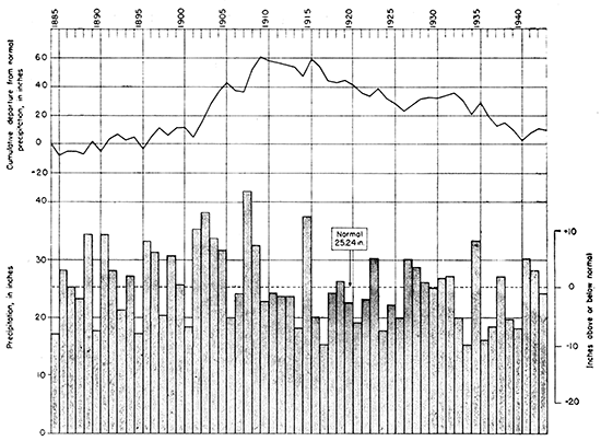
Table 3--Average annual precipitation and average annual departure from normal for 10-year periods from 1885 to 1942 at Concordia, Kansas
| Period | Average annual precipitation, inches |
Average annual departure from normal, inches |
|---|---|---|
| 1885-1894 | 25.73 | +.49 |
| 1895-1904 | 28.40 | +3.16 |
| 1905-1914 | 26.30 | +1.06 |
| 1915-1924 | 23.65 | -1.59 |
| 1925-1934 | 24.16 | -1.08 |
| 1935-1944 | 25.51 | +.27 |
The mean temperatures at Belleville and Concordia are 53.1° and 53.8° F., respectively. The growing season in Republic County has ranged from 128 to 197 days and averages 163 days. The latest date of a killing frost in the spring is May 24 while the earliest date of a killing frost in the fall is September 20.
Prev Page--Introduction || Next Page--Geology
Kansas Geological Survey, Geohydrology
Placed on web Nov. 8, 2016; originally published May 1948.
Comments to webadmin@kgs.ku.edu
The URL for this page is http://www.kgs.ku.edu/Publications/Bulletins/73/03_geog.html