![]()
Prev Page--Geography || Next Page--Ground Water
Geology
Summary of Stratigraphy
The rocks exposed in Republic County and northern Cloud County are of Cretaceous and Quaternary age. The areal distribution of the formations is shown in Plate 1. The oldest formation cropping out in the area is the Dakota formation of Cretaceous age, which is exposed in the southeastern part of Republic County and in northern Cloud County. The overlying Graneros shale and Greenhorn limestone of Cretaceous age are best exposed in the eastern and southern parts of Republic County along the edges of the streams where the overlying Carlile shale, also of Cretaceous age, has been eroded away. The Carlile shale mantles the upland areas in the west-central, central, and eastern parts of Republic County. The Pleistocene deposits, which include the Belleville formation and the loess deposits, comprise the surface materials in a large area in northern Republic County. Loess covers much of the area underlain by the Belleville formation and also mantles the Cretaceous rocks in parts of the area to the south. The soils and alluvium are the most recent deposits in the area.
The character and ground-water supply of the geologic formations in Republic County and northern Cloud County are described briefly in the generalized section (Table 4) and in more detail under "Water-bearing formations."
Table 4--Generalized section of the geologic formations in Republic and Cloud counties, Kansas.
| System | Series | Subdivision | Thickness (feet) |
Physical character | Water supply | |
|---|---|---|---|---|---|---|
| Quaternary | Recent and Pleistocene |
Alluvium and Terrace deposits |
0-125 | Sand, gravel, and silt, comprising stream deposits in the Arkansas Valley and in the valleys of many smaller streams, Coarse gravels occur as terrace deposits bordering the present flood plain of Republican River at levels of 10 to 20 feet above the flood plain. | The alluvium yields large supplies of water to wells in the Republican Valley and lesser amounts in the smaller stream valleys; supports some irrigation wells in the Republican Valley. Some waters from the alluvium are very hard. having from 160 to 1.198 parts per million of hardness. Locally in Cloud County the waters contain up to 13.000 parts per million of chloride. | |
| unconformable on older formations | ||||||
| Pleistocene | Loess | 0-40 | Buff silt at top ("Peorian"), underlain by thin dark soil zone, underlain in turn by reddish-brown silt ("Loveland") containing some fine sand and clay and, locally near the base, some coarse sand and fine gravel. | Does not yield water to wells in Republic and Cloud Counties. | ||
| unconformable on older formations | ||||||
| Belleville formation | 0-235 | Sand, gravel, and silt comprising stream deposits in and near the ancestral Republican River Valley. | Yields abundant supplies of good water to wells. The hardness of the water generally ranges from 250 to 500 parts per million. | |||
| unconformable on older formations | ||||||
| Cretaceous | Gulfians* | Carlile shale |
Blue Hill shale member |
280± | Shale, blue-gray, massive to thin bedded. | Yields little or no water to wells in Republic and Cloud Counties except the weathered zone which yields only meager supplies. |
| Fairport chalky shale member |
||||||
| Greenhorn limestone |
Pfeifer shale member |
15-16 | Chalky shale with beds of thin chalky limestone, discoided concretions, and thin beds of bentonite. "Fencepost limestone" at top. | Very few wells obtain water supplies from the Greenhorn limestone in Republic and Cloud counties. Only very limited supplies of comparatively hard water may be expected from wells penetrating this formation. | ||
| Jetmore chalk member |
13-14 | Alternating beds of chalky shale and chalky limestone, "shell" limestone at top. | ||||
| Hartland shale member |
45-53 | Chalky shale with a few thin beds of chalky limestone and bentonite. | ||||
| Lincoln limestone member |
Yellowish chalky shale with hard, thin-bedded, finely-laminated, crystalline limestone at top and bottom and a few thin beds of chalky limestone. | |||||
| Graneros shale | 20-30 | Dark bluish-black. fissile. noncalcareous clay shale with numerous thin lenses of sandy shale, sandstone, and interbedded ironstone concretions. | No wells are known to derive water supplies from this formation in Republic and Cloud counties. | |||
| Dakota formation | 300± | Fine-grained, gray to white to yellow-brown sandstone, irregularly bedded, and varicolored clay and sandy shale. | Sandstone yields abundant supplies of water having wide range in quality. Generally shallow wells yield water of good quality and deep wells yield water of poor quality. | |||
| * This term which is employed by the State Geological Survey of Kansas has not been adopted by the Federal Geological Survey. Cretaceous stratigraphy after Wing (1930). | ||||||
Pre-Cenozoic Geologic History
Although the oldest rocks exposed at the surface in Republic County and northern Cloud County belong to the Dakota formation, it is known from the records of several deep tests for oil and gas in the area that the exposed rocks are underlain by older sedimentary rocks of Paleozoic age, which in turn rest upon crystalline rocks of pre-Cambrian age. The geologic history during the Paleozoic and Mesozoic eras discussed on the pages that. follow is based largely on reports by Wing (1930) and Landes and Ockerman (1930, pp. 39-40).
Paleozoic Era
Just as the Dakota formation underlies the stratigraphically higher and younger formations which occur at the surface toward the west, it in turn is underlain by older formations which crop out successively at the surface to the east. These older formations may be studied by examining records and drill cuttings of deep wells and by examining the outcrops to the east. Many deep wells have been drilled in Republic and Cloud counties but only the Murdock well (sec. 6, T. 6 S., R. 4 W.) is known to have penetrated rocks older than the Pennsylvanian. Hence, much of the geologic history of this area during the Paleozoic Era is surmised from the logs of deep wells in near-by counties and the outcrops of the rocks to the east. According to Landes and Ockerman (1930, p. 39) the region at the beginning of the Cambrian period probably was a broad undulating plain underlain by granite and other crystalline rocks. Erosion of the pre-Cambrian surface was brought to an end in Late Cambrian or Early Ordovician times by submergence beneath the sea. Deposition of limestone and shale occurred during the Ordovician and Silurian, and continued on into the Devonian period when the land rose above the sea and erosion began. As a result of his study of the log of the Murdock well, Wing (1930, p. 36) believes that rocks of Mississippian age are absent in Republic and Cloud counties. If ever deposited, these rocks seemingly were all removed by erosion during the emergence of the land at the end of Mississippian time. After Mississippian time the area was again inundated by the Pennsylvanian sea advancing from the southeast.
The Pennsylvanian was predominantly a time of deposition of shale and limestone. The rocks laid down during the Pennsylvanian include in ascending order the Cherokee, Marmaton, Kansas City, Lansing, Douglas, Shawnee, and Wabaunsee groups and comprise about 1,300 feet of alternating beds of limestone and shale. Although no evidence of unconformity at the base of Permian rocks is known from study of wells in the Republic-Cloud county area, deep channels were eroded in the uppermost Pennsylvanian deposits farther east near Missouri River and these valleys were filled with basal Permian sand. Probably there was a corresponding interruption of sedimentation in the area treated in this report. The first deposits of Permian age in Republic and Cloud counties were gray shale, anhydrite, gypsum, salt, and a few beds of limestone. Later in the Permian, thick deposits of red beds were laid down under nonmarine conditions.
Mesozoic Era
Deposition evidently was terminated by an uplift that brought the region above water at the close of the Paleozoic Era. Probably this condition extended through the latter part, if not all, of Triassic time and through Jurassic time, during which there was no deposition and probably considerable erosion. According to Wing (1930, p. 12) rocks representing the Triassic and Jurassic are not known to occur in Republic and Cloud counties. Also the Early Cretaceous deposits are absent in this area. In Late Cretaceous time the deposits of the Dakota formation were laid down in fresh water on beaches and near the shore during an uplift in which the sea retreated far to the south. Further submergence permitted the marine water to cover the land again and the Graneros shale and the limestones and limy shale of the Greenhorn limestone were deposited. There followed a time when the sea received large amounts of clay and silt from the streams emptying into it, and the Carlile shale was deposited. Still younger Cretaceous rocks crop out just to the west of these counties and probably also covered these counties but were later removed by erosion, as described below. At the close of the Cretaceous Period movements of the earth crust produced the Rocky Mountains and affected at least in part the rocks in north-central Kansas. During this time the Cretaceous and older rocks in the area probably were tilted to produce their present regional dip to the northwest (Wing, 1930, Pl. 16).
Cenozoic Geologic History
By S. W. Lohman
Tertiary Period
After the tilting of Cretaceous and older rocks at the close of the Mesozoic Era, there was a long period of erosion that persisted throughout most, if not all, of the Tertiary Period, truncating the Cretaceous sediments. Toward the close of Tertiary time, during the Pliocene Epoch, aggrading and laterally shifting streams deposited the silts, sands, and gravels comprising the Ogallala formation over large areas in western Kansas. No deposits of Tertiary age are now found in Cloud and Republic counties, and if any such materials were deposited they were removed by post-Pliocene erosion.
Quaternary Period
Pleistocene Epoch
The major events of the Pleistocene Epoch in this area are downcutting and aggradation of the major streams, important drainage changes, and deposition of loess.
During early Pleistocene time or possibly late Pliocene time the ancestral Republican River channel was cut, not where the present stream flows, but along the east-trending buried channel in northwestern Republic County revealed by test drilling (Pls. 2 and 5). Upstream from this area in Nebraska, where the channel has been traced also by test drilling (Cady, in press), the old channel trends generally west-east parallel to the present channel in a course mainly north of it. Turning southeast the old channel meets the modern stream near Bostwick, Nebraska. Cady concluded that the ancient channel entered Kansas where the modern channel enters, but evidence (Pl. 2) has been obtained to show that it crossed the state line somewhat west of this point and passing through northeastern Jewell County, Kansas, entered Republic County at a point 5 miles south of the Nebraska line; it crossed the present channel near the City of Republic and again entered Nebraska near Chester. Its course northeastward into Nebraska has been traced by subsequent test drilling by the Nebraska and Federal Geological Surveys, the results of which are to be published later.
The approximate shape and gradient of the ancient channel in Republic County and suggestions of several tributary channels are shown on Plate 2. The cutting of this channel may have begun before the close of Tertiary time or may have followed a pre-existing Tertiary drainageway, but probably it took place early in the Pleistocene--possibly in early Nebraskan time, as held by Cady (in press).
It is believed that Marsh Creek, which now heads just south of a "wind gap" at the NW cor. sec. 27, T. 2 S., R. 6 W., in Jewell County, just 2 miles west of the Republic County line, formerly carried most of the drainage of what is now White Rock Creek, and that the ancestral Marsh Creek was beheaded by a small tributary of the deepening ancestral Republican River, or that possibly this piracy occurred during the cutting of the present channel described below. White Rock Creek now flows about 1.5 miles north of this "wind gap" and less than 20 feet below the highest point in the saddle of the gap, which is between hills capped by the Niobrara formation. Moreover, the gradient of the present White Rock Creek is considerably steeper downstream from the vicinity of the abandoned gap.
That the ancestral Republican River entered Kansas, flowed across part of Republic County, and re-entered Nebraska near Chester is clearly demonstrated by the records of test holes as described above (Pls. 2 and 5). The remaining question is what later caused this stream to abandon its former well-established course and turn abruptly south past Scandia to Concordia and thence eastward and southeastward to join Kansas River near Junction City. A review of the available evidence indicates that this major change in drainage and the filling of the old channel may have taken place somewhat as follows.
Filling of the ancestral channel by the coarse sand and gravel forming the lower part. of the Belleville formation may have begun during the Nebraskan Stage of glaciation, if Lugn (1935, p. 92) is correct in contending that the equivalent Holdrege formation of Nebraska was formed as an "inwash-outwash fluvio-glacial deposit" in Nebraskan time. According to Cady (in press) valley filling may have ceased temporarily and perhaps some deposited material may have been excavated. According to Lugn (1935, p. 98) the Fullerton formation was deposited in parts of Nebraska during the Aftonian interglacial stage.
Todd (1909, pp. 108-110) presented evidence that as the glacier advanced westward during the Kansan Stage it successively dammed streams draining what is now the Missouri River Basin, forcing the waters from a vast area to find new southward courses along the western border of the glacier. Todd (1919) concluded that during this stage the glacier extended only as far westward as the present Big Blue River in Marshall County, Kansas, and suggested that at the time of maximum ice advance the major drainage was carried by the ancestral Big Blue River to a point in Nebraska where that stream was blocked by the ice, thence across to the ancestral Little Blue River at Fairbury, Nebraska, down that stream into Marshall County, Kansas, where it rejoined the ancestral Big Blue River and was carried to the ancestral Kansas River. Later evidence (Lugn, 1934, fig. 186; Schoewe, 1939), however, indicates that during the Kansan Stage the glacier extended farther west, blocking not only the ancestral Big Blue but also the ancestral Little Blue River, so that still another outlet must be found that might have carried the large volume of water from parts of Montana, Wyoming, Colorado, North Dakota, South Dakota, and Nebraska. The evidence presented below indicates that the outlet for this drainage during the maximum advance of the glacier was by way of the new and present course of Republican River southward through Republic County to Concordia and thence eastward and southeastward to the ancestral Kansas River.
After the ancestral Republican River Valley was cut and partly filled with early Pleistocene sand and gravel, and after the temporary cessation of valley filling as described above, there is evidence (Cady, in press) of a second alluviation in the Republican Valley area during which time the upper part of the Belleville formation was deposited in Republic County. This corresponds to the deposition of Lugn's (1935, pp. 103-104) Grand Island formation in central Nebraska, which he interpreted as Kansan in age. This deposit covered a wide area in central Nebraska (Lugn, 1934, fig. 186), including not only the stream valleys but also large interstream areas, and in Republic County the filling seems to have extended to about the crest of the old divide south of the ancestral Republican River (Pls. 1 and 2). At this time the lowest point along the old divide seemingly lay between Republic and Scandia, and an important tributary of the ancestral Kansas River probably headed just south of this low point and drained southward and eastward past the site of Concordia. At the time of maximum advance of the glacier during the Kansan Stage, the eastward-flowing ancestral Republican River was effectively dammed, forcing the ponded waters to spill over this low divide and be captured permanently by the southward flowing tributary-part of the present Republican River.
Some water may have spilled over at other points along the old divide, but it seems reasonable to assume that the maximum flow took place between Republic City and Scandia, for the new channel was formed there and has remained there. Supporting evidence is afforded by the bedrock-contour map of the present Republican River Valley (Pl. 2) and successive cross sections B-B', H-H', J-J', K-K', and L-L', of the valley between Republic City and Concordia (Pl. 5). Thus, the steepest gradient along the base of the bedrock channel occurs at or just north of Scandia between sections H-H' and J-J'; the narrowest part of the spillway occurs at or north of section J-J'; and, as shown on the topographic map of the Concordia quadrangle, the narrowest and steepest-sided part of the Republican River Valley in the area occurs along this stretch. Also, the bedrock contours and the successively thicker valley fill shown in sections southward from line H-H' indicate a concave-upward stream profile such as is characteristic of the headwater region of a stream--here the old tributary leading southward, modified only by downcutting of the spillway through the nonresistant Carlile shale. The cutting of the new channel left the ancestral channel and valley filled with sand, gravel, and some clay of the Belleville formation.
After the downcutting of the channel a change in conditions caused the Republican River to fill the channel with alluvium, as shown in the cross sections. The alluvium differs in composition from the Belleville formation (p. 91) and hence probably came in part from different sources. As stated by Cady (in press):
It [the alluvium] is gray, coarse, well sorted sand, composed partly of crystalline rock particles from the mountains to the west, and partly of local rock particles. Of the latter material the glistening green "quartzite" from the Ogallala formation in the (western) Republican Valley area is most conspicuous. There is also gravel in the alluvium. Part of the pebbles are crystalline, derived no doubt from earlier deposits in the valley, but ultimately derived from regions far to the west. Local rocks, particularly the Niobrara formation, are represented in the gravel, especially in the lower zones.
After deposition of the Belleville formation and before the overlying "loess" was laid down some of the sand and gravel was reworked by rain and small streams into thin deposits of stratified sand and pebbles that generally are not cross bedded as are those of the Belleville formation. Then followed the widespread deposition of a reddish-brown silt and clay, containing some grains of sand and some organic material, which is about 100 feet thick over the filled channel of the ancestral Republican River. This material is widespread in Nebraska where it has been called the Loveland formation or Loveland loess by Lugn (1935, p. 128) who correlated it with similar material in Iowa described earlier by Shimek (1909). Kay (1928) established the age of the Loveland in Iowa as probably Sangamon, or post-Illinoian. Lugn (1935, pp. 131-132) regarded the Loveland loess of eolian origin and thought that the color of the Loveland was originally red, concluding that the material making up the deposit was blown in from regions to the southwest where redbeds are exposed. Cady (in press) presents evidence that the loess probably is chiefly of local eolian origin and that the red color is secondary and was derived from the oxidation of an iron-rich deposit whose original color probably was gray or greenish gray. A recent study of loess in Louisiana by Russell (1944) indicates that at least in some places loess may have been formed from stream-laid deposits that have undergone a secondary process described by him as loessification.
After the deposition of the "loess," correlated with the Loveland loess of Nebraska, the material was subjected to erosion and weathering. This old weathered surface is well preserved by a fossil soil zone (Pl. 6B) as much as 2 to 3 feet thick (p. 93). In some places this soil zone and part or all of the underlying "Loveland loess" was eroded away before deposition of the overlying younger loess.
After the formation and erosion of the soil formed on the "Loveland loess," a deposit of light grayish-buff or yellow silt which Lugn (1935, p. 158) called the "Peorian loess" was laid down as a thin blanket on the older materials (Pls. 6B and 7A), and generally overlies the soil zone described above, to which an eolian origin has been ascribed by most geologists. Leighton (1931) states that this material was deposited during the Iowan and early Wisconsin glacial stages and Kay (1939) associates it with the Iowan and Tazewell drifts.
Plate 6--A, Palate of Stegomastodon, taken from gravel pit shown in plate 7B. B, Exposure of loess along small stream in the NE SE NE sec. 13, T. 1 S., R. 11 W. Top to bottom: Recent soil, buff "Peorian loess," dark soil zone (marked by geology pick), reddish-brown "Loveland loess," and at bottom--cross-bedded sand of Belleville formation. (Photograph by S. W. Lohman.)
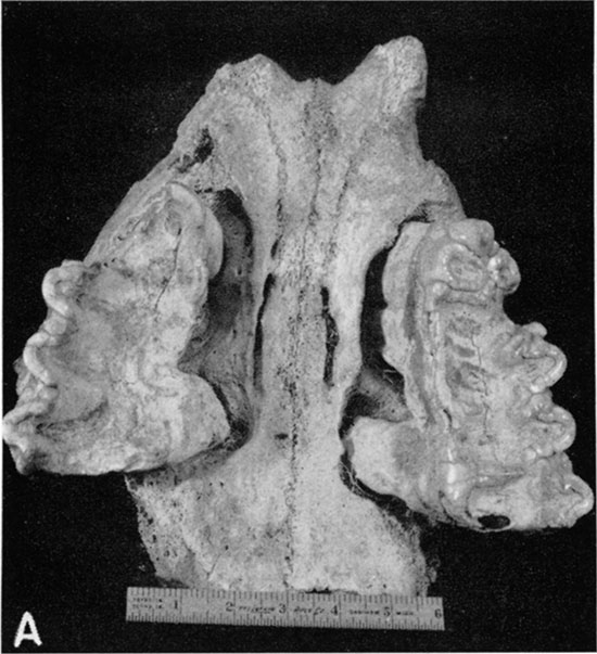
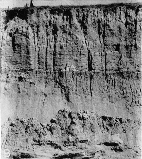
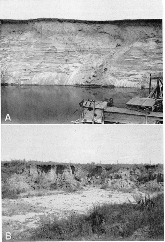
Plate 7--A, Sand and gravel pit just south of Cowles, Webster County, Nebraska, in sec. 9, T. 2 N., R. 10 W. Section at extreme left, top to bottom: Recent soil, brownish Loveland loess, sand and gravel of Grand Island formation, below water line is at least 55 feet of sand and gravel belonging to Grand Island and Holdrege formations. Section at middle and right: Recent soil, Peorian loess resting on uneven erosion surface from which Loveland loess has been removed, rest of section same as at left. (Photograph by S. W. Lohman.) B, Gravel pit in sec. 15, T. 2 S., R. 2 W., Republic County, Kansas, in Belleville formation from which the fossil shown in Plate 6A was obtained.
Late Pleistocene and Recent Events
After the alluviation of the present Republican River Valley, subsequent changes caused at least two renewals of downcutting which produced two stream-graded levels. The lower one comprises the present flood plain of the river; the higher is preserved as a terrace at a few places and is shown in sections H-H' and K-K' (Pl. 5). The terrace generally is underlain principally by silt resembling somewhat the "loess" described above, but is probably composed of reworked material carried in by streams or by early floods of the main river.
Some of the surficial alluvium in the Republican River Valley and along minor stream valleys (p. 95) was laid down in Recent time and probably the swamps along Marsh and Salt Creeks (pp. 16-17) also were formed rather recently. Post-Pleistocene erosion which has modified the landscape in many parts of the area was accompanied by the formation of sand dunes in the area northeast of the City of Republic.
Prev Page--Geography || Next Page--Ground Water
Kansas Geological Survey, Geohydrology
Placed on web Nov. 8, 2016; originally published May 1948.
Comments to webadmin@kgs.ku.edu
The URL for this page is http://www.kgs.ku.edu/Publications/Bulletins/73/04_geol.html