![]()
Prev Page--Contents || Next Page--Geography
Introduction
Purpose and Scope of the Investigation
The investigation upon which this report is based is part of an extended program of groundwater investigations in Kansas begun in July, 1937, by the United States Geological Survey and the State Geological Survey of Kansas in cooperation with the Division of Sanitation of the Kansas State Board of Health and the Division of Water Resources of the Kansas State Board of Agriculture. Similar investigations are being conducted in several other counties in Kansas.
The Bureau of Reclamation has been making a survey of the Republican River Valley primarily to determine the potential irrigation development of the basin. In its investigation of the valley between the Nebraska State line and Concordia, Kansas, the Bureau has been interested in the relative desirability of irrigating valley lands with ground water or by a system of canals diverting water from Republican River or by a combination of both. Some of the arable land is situated so as to be irrigable more feasibly using ground water than surface water.
A. W. Redman, engineer of the Bureau of Reclamation, made a reconnaissance of the area during the summer of 1941. He obtained information regarding the existing irrigation wells, measured the water levels in several domestic wells, and selected some sites for test drilling. Five test holes were drilled by William Steele, well driller employed by the Bureau of Reclamation, in August 1941. The Bureau of Reclamation concluded from these preliminary surveys that ground-water irrigation was feasible in a part of the area but that a more intensive investigation of the ground-water resources of the area should be made. They proposed that the investigation should be made in cooperation with other interested Federal and State agencies in Kansas. In December 1941, C. T. Judah, engineer in charge of the Bureau's hydrologic investigations in the Republican River Valley, conferred in regard to this proposed study with R. C. Moore, State Geologist, George S. Knapp, Chief Engineer, Division of Water Resources, State Board of Agriculture, and S. W. Lohman, Federal Geologist in Charge of ground-water investigations in Kansas, and plans were laid for the cooperative investigation that was made during the summer of 1942. It was agreed that the investigation should include all of Republic County and the Republican River Valley down to Concordia and that the investigation of the groundwater resources of the Republican River Valley would be in cooperation with the Bureau of Reclamation. The investigation was made under the general administration of R. C. Moore, State Geologist, and J. C. Frye, Executive Director, State Geological Survey of Kansas and O. E. Meinzer, Geologist in Charge, Division of Ground Water, Federal Geological Survey, and under the direct supervision of S. W. Lohman, Federal Geologist in Charge of ground-water investigations in Kansas.
Location and Extent of the Area
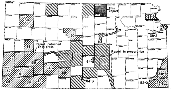
The area considered in this report includes Republic County and part of Cloud County that lies in the Republican River Valley. Republic and Cloud counties lie in the first and second tiers of counties respectively from the north border of the State and a short distance east of its center. Republic County has a total of 20 townships or an area of 719 square miles. Its location with respect to adjoining counties is shown in Figure 1.
Figure 1--Area covered by this report and other areas in Kansas for which cooperative ground-water reports have been published or are in preparation.
Previous Investigations
The more important studies dealing with the geology and ground-water resources of north-central Kansas that have a bearing on Republic County are cited below. Specific references are cited at appropriate places in the text by author and date and are listed in the references at the end of the report.
The geology of the Upper Cretaceous in Kansas was described by Logan in 1897. Darton (1905, pp. 289, 292, 313) made reference to a few wells in this area in a preliminary report on the geology and ground-water resources of the central Great Plains. Because of the severe drought culminating in 1913 that resulted in water shortages in a large part of the State Haworth (1913, pp. 40-43) prepared a special report on well waters in Kansas in which he discussed the availability of ground water in the Republican River Valley. A report by Wing (1930) on the geology of Cloud and Republic counties was the first detailed report on the area. Wing's report included a very brief discussion of the availability of ground water. The Dakota formation in adjacent areas was described by Tester in 1931. In 1940, Moore and others prepared a generalized report on the ground-water resources of Kansas. A very detailed study of the outcrop area of the Dakota formation was made by Plummer and Romary (1942). An investigation was made by Cady (in press) of the ground-water resources of the Republican River Valley in Nebraska adjacent to Republic County.
Methods of Investigation
Three months were spent in Republic and northern Cloud Counties during the summer of 1942, of which about two months were spent in the Republican River Valley obtaining data for this report. S. W. Lohman spent a few days in the field during the summer of 1942 and in the summer of 1944 I was accompanied in the field for three days by Mr. Lohman and C. C. Williams of the Federal Geological Survey and C. W. Hibbard, vertebrate paleontologist of Dyche Museum of Natural History, University of Kansas. Approximately 275 wells were visited and the total depth of the well and depth to water level below land surface were measured using a steel tape. Well owners and drillers were interviewed regarding the nature and thickness of the water-bearing formations penetrated by the wells, and all available logs were collected. Records of wells that furnish public, domestic, and irrigation supplies were collected. Information regarding the yield and drawdown of wells, and the temperature, chemical character, and use of ground water was obtained.
Samples of water from 51 wells were collected; they were analyzed by H. A. Stoltenberg, Chemist, in the Water and Sewage Laboratory of the Kansas State Board of Health at Lawrence. In addition analyses of water from 6 public supplies in Republic County were furnished by the Kansas State Board of Health.
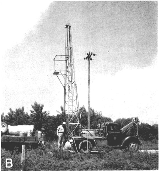
During the investigation 113 test holes (Pl. 2) were put down in the area by Ellis D. Gordon, James B. Cooper, Oscar S. Fent, Milford Klingaman, and John J. Conard using a portable hydraulic-rotary drilling rig owned by the State Geological Survey (Pl. 3B). Samples from the test holes were collected and studied in the field by Cooper or Fent and were again studied in the office by me. Logs of 4 test holes in the Republican River Valley were furnished by the Bureau of Reclamation. Logs of 22 test holes near Scandia, 7 test holes near Concordia, and 13 test holes north of Belleville were kindly supplied by the Layne-Western Company, Kansas City, Missouri. Logs of 7 test holes near Concordia were furnished by the Air-Made Well Company.
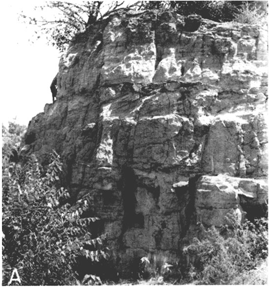
Plate 3--A, Sandstone of the Dakota formation in Concordia on east side of U. S. Highway 81. B, Portable drilling machine owned by the State Geological Survey, used in drilling test holes in Cloud and Republic counties.
The altitudes of the measuring points of the wells and the test holes in the Republican River Valley were determined by Fred A. Maynard, engineer of the Bureau of Reclamation, using a spirit level. Mr. Maynard also assisted me in an inventory of the wells in the Republican River Valley. The altitudes of the measuring points of the wells and test holes in northern Republic County were determined by C. K. Bayne, S. C. Brown, and R. N. Tripp of the State Geological Survey, using a spirit level.
Pumping tests on two irrigation wells (245 and 254) were made by Kenneth D. McCall, engineer of the State Division of Water Resources, and Woodrow W. Wilson, engineer of the Federal Geological Survey. These tests were made to determine the yield of the wells and the permeability of the water-bearing materials.
The base map for Plates 1 and 2 was prepared from county maps compiled by the State Highway Department. The locations of the roads were corrected from observations in the field and the drainage pattern was corrected from observations in the field and from aerial photographs obtained from the United States Department of Agriculture, Agricultural Adjustment Administration. Plate 1 shows the locations of all the wells visited during the course of the investigation. The wells are numbered in order by townships from north to south and by ranges from east to west. Within a township they are numbered in the same order as the sections.
Fossil teeth collected from the Pleistocene sand and gravel deposits in northern Republic County were identified by Mr. Hibbard.
Acknowledgments
I am indebted to the many residents of the area who readily gave permission to measure their wells, and who supplied helpful information regarding them. Much helpful information was supplied by Dr. E. P. Ahrens of Scandia, Kansas, Director, National Reclamation Association; Glenn B. Snapp, President, North Central Kansas Electric Cooperative, Inc., and Benton Bachelor and John Umberger, members of the Water Conservation Committee of the Belleville Chamber of Commerce.
Logs of test holes put down by the Layne-Western Company were kindly furnished by R. O. Joslyn, president of that company.
The manuscript for this report has been critically reviewed by several members of the Federal Geological Survey; R. C. Moore, Director of Research, and John C. Frye, Executive Director, State Geological Survey of Kansas; George S. Knapp, Chief Engineer, Division of Water Resources, Kansas State Board of Agriculture; Paul D. Haney, Director and Chief Engineer, and Ogden S. Jones, Geologist, Division of Sanitation, Kansas State Board of Health. This report has been edited by Betty J. Hagerman of the State Geological Survey and the illustrations were drafted by Robyn Ashby and Robert White of the State Survey.
Prev Page--Contents || Next Page--Geography
Kansas Geological Survey, Geohydrology
Placed on web Nov. 8, 2016; originally published May 1948.
Comments to webadmin@kgs.ku.edu
The URL for this page is http://www.kgs.ku.edu/Publications/Bulletins/73/02_intro.html