![]()
Prev Page--Contents || Next Page--Water Use
Introduction
The Dakota aquifer is the most geographically extensive aquifer in Kansas, although the extent of freshwater is less than that of the High Plains aquifer (HPA). The Dakota has been used as a source of water in Kansas since before 1900. The aquifer system, which underlies most of the western two-thirds of Kansas, consists of the Cretaceous Dakota and Kiowa formations and Cheyenne Sandstone. The current and potential importance of the Dakota as a source of water in Kansas and the need to protect it from contamination by human activities have been of paramount importance to water planning and regulatory agencies. Although previous studies have improved the understanding of Dakota aquifer hydrology and water quality (Keene and Bayne, 1977; Lobmeyer and Weakly, 1979; Kume, 1984; Kume and Spinazola, 1982, 1985), a substantial amount of additional information was needed for management of the Dakota aquifer.
To address these issues, the Kansas Geological Survey (KGS) proposed and pursued an eight-year, multidisciplinary research effort, the Dakota Aquifer Program, to develop a better conceptual understanding of the geologic framework, flow systems, and aqueous geochemistry of the Dakota aquifer, including its confining layers and interactions with other aquifers. The objectives of the program included assessing the groundwater quality of the Dakota aquifer, contamination sources, and the impact of the quality on usable water resources. Publications derived from this program include a KGS technical series (Macfarlane, Doveton, and Whittemore, 1998) and Current Research paper (Macfarlane, 1995), KGS public information circulars (Macfarlane and Sawin, 1995; Macfarlane, 1997a, 1997b; Macfarlane, Whittemore, and Doveton,1998), journal papers (for example, Macfarlane, Doveton, et al., 1994; Macfarlane et al., 2000; Clark et al., 1998), and KGS open-file reports (for example, Macfarlane et al., 1988, 1990, 1991, 1992; Macfarlane, Whittemore, et al., 1994; Whittemore et al., 1993; Macfarlane and Whittemore, 1996). Web pages also provide information and data about the Dakota aquifer (http://www.kgs.ku.edu/Dakota/vol1/dakotaHome.html). Concurrent with the Dakota program of the KGS, the U.S. Geological Survey (USGS) conducted a regional investigation of the Great Plains aquifer system (which is equivalent to the Dakota aquifer in Kansas) primarily in Nebraska, Colorado, and Kansas (Helgeson et al., 1993).
After the Dakota program ended, development of online data bases for water-right and well log data, as well as development of user-friendly geographic information tools, facilitated locating and estimating yields for wells that draw water entirely or partially from the Dakota aquifer. This bulletin presents an overview of estimated recent water use from the Dakota aquifer; results of the Dakota program; results of later work on water-quality and geochemical studies; descriptions of suitability areas for water supply based on hydrogeology and water quality; and an assessment of other factors related to water-resource development and management. The bulletin consists of a main summary and an online appendix that contains more detailed descriptions of procedures and additional results and discussion (http://www.kgs.ku.edu/Publications/Bulletins/260/appendix.html).
Dakota Aquifer System
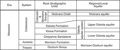
The Dakota aquifer has been defined by Macfarlane (2000) as the sandstone aquifers in the Lower Cretaceous Dakota and Kiowa formations and the Cheyenne Sandstone (fig. 1). Sandstones in the Cheyenne Sandstone, a valley-fill deposit at the base of the Lower Cretaceous Series, and in the overlying Kiowa Formation are thin and of limited extent. Thick, deltaic, and shoreline sandstones are locally developed in the Longford Member and Longford-equivalent strata in the Kiowa Formation in central Kansas. In contrast, sandstones in the Dakota Formation are widespread in Kansas because they were deposited on a broad, low-relief coastal plain adjacent to the developing Western Interior sea. In the rules and regulations of the Kansas Department of Agriculture, Division of Water Resources (DWR) (K.A.R. 5-1-1, 2011), the Dakota aquifer system is said to "include the Dakota formation, the Kiowa formation, the Cheyenne Sandstone, and, where hydraulically connected, the Morrison formation." The names of the Dakota and overlying and underlying Mesozoic Era aquifers and their rock stratigraphic equivalents in Kansas are shown in fig. 1. The Upper Dakota aquifer consists of sandstones in the Dakota Formation, and the Lower Dakota aquifer includes sandstones in the Longford Member of the Kiowa Formation and the Cheyenne Sandstone (Macfarlane, 2000). During the Regional Aquifer Systems Analysis of the USGS, most of the principal aquifers were renamed to reflect large-scale hydraulic continuity across state lines (Helgeson et al., 1993). The USGS used the names Maha aquifer, Apishapa confining unit, and Apishapa aquifer for the Upper Dakota aquifer, Kiowa Shale aquitard, and Lower Dakota aquifer, respectively.
Figure 1--Nomenclature for aquifers of the Mesozoic era in Kansas.
The extent of the Dakota aquifer system in Kansas is shown in fig. 2. Not all of the geologic formations comprising the Dakota aquifer are present throughout the aquifer's extent (Macfarlane, 2000). In western and parts of central Kansas, the Dakota aquifer system is separated into upper and lower aquifers by an aquitard within the Kiowa Formation. Over much of central Kansas, the aquitard in the Kiowa is not present, and the upper and lower aquifer units cannot be differentiated.
Figure 2--Extent of the Dakota aquifer system in Kansas.
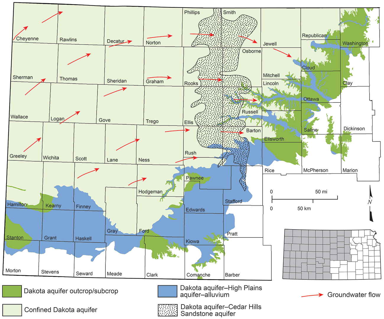
Strata of the Dakota aquifer outcrop primarily in the eastern extent of the aquifer in Kansas, although small outcrop areas also exist in south-central Kansas (fig. 2). The aquifer is unconfined in this region as well as in areas where it is covered by alluvium (subcrop). It is also generally considered as unconfined where it is overlain by and hydraulically connected to the HPA in south-central and southwest Kansas. Most of the Dakota aquifer strata in Kansas are confined by overlying Upper Cretaceous shales and limestones. The Jurassic Morrison Formation underlies the aquifer in the northwest and westernmost parts of west-central and southwest Kansas (Merriam, 1963; Macfarlane, 2000). Elsewhere, the Dakota aquifer is underlain by Permian strata. Of particular significance is the Permian Cedar Hills Sandstone, which underlies the aquifer in parts of north-central and central Kansas (fig. 2). Saltwater in the Cedar Hills intrudes into the Dakota aquifer and substantially affects the water quality, as is described later in this bulletin.
Maps of the top and bottom configuration and of the potentiometric surface of the Dakota aquifer are available online at http://www.kgs.ku.edu/Dakota/vol3/bigmaps/index.htm. The combined thickness of Dakota, Kiowa, and Cheyenne units ranges up to more than 700 ft (210 m) in parts of west-central Kansas (Macfarlane, 1997a). More detailed maps of the top configuration and thickness of the upper Dakota aquifer, Kiowa Shale aquitard, lower Dakota aquifer, Morrison-Dockum aquifer (fig. 1), and overlying Upper Cretaceous and underlying Permian units are available in Macfarlane et al. (1993) (also available online at http://www.kgs.ku.edu/Hydro/Publications/1993/OFR93_1a/index.html).
The sandstone bodies that comprise the Dakota aquifer system are encapsulated in shales that are a part of the geologic units. Overall, less sandstone than shale exists in the system. The total thickness of sandstone in the Dakota aquifer ranges from less than 5% to more than 50% of the combined thickness of the Dakota and Kiowa formations and the Cheyenne Sandstone and varies dramatically even over distances of less than a few miles. The discontinuous sandstone bodies are generally lens shaped, rather than flat and continuous. Typically, the best sandstone aquifers are up to 100 ft (30 m) thick, 1.5 mi (2.4 km) wide, and 20 mi (32 km) or more long.
Prev Page--Contents || Next Page--Water Use
Kansas Geological Survey, Geohydrology
Placed on web Nov. 6, 2014; originally published Fall 2014.
Comments to webadmin@kgs.ku.edu
The URL for this page is http://www.kgs.ku.edu/Publications/Bulletins/260/02_intro.html