Kansas Geological Survey, Open-file Report 93-1a
by P. Allen Macfarlane, J. Combes, S. Turbek, and D. Kirshen
KGS Open File Report 93-1a
December, 1993
This report introduces a companion atlas of the shallow subsurface bedrock geology and hydrostratigraphy of southwestern Kansas. The atlas consists of 18 plates showing the top configuration and thickness of 9 hydrostratigraphic and stratigraphic units. The maps were derived from geophysical logs and other supplementary subsurface information and were produced using the ARC/RIFO geographic information system.
A significant part of the research effort in the Kansas Geological Survey's ongoing Dakota Aquifer Program has gone into mapping the hydrostratigraphy, i.e. the aquifers and aquitards, in the rock units beneath the Ogallala and undifferentiated Pleistocene deposits in western and central Kansas. In some instances, the purpose of this effort is to update existing maps, but in others, the effort has been to develop a clearer understanding of the spatial relationship between these units in the subsurface. These maps are being used in the program provide data for ongoing regional and subregional flow modeling efforts during State FY93-95. Others outside the program will also find these maps useful, including state and local planning and regulatory agencies, water well drillers, and others interested in the significant features of the shallow subsurface hydrogeology of southwestern Kansas. In southwestern and west-central Kansas, some of the major planning and regulatory issues focus on the hydraulic connection between aquifer units and water availability. It is hoped that the maps produced by this research effort will provide much-needed information to address these topics.
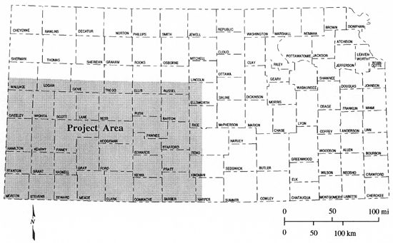
The mapped area, shown in Figure 1, is located in southwestern Kansas and extends southward from T. 14 S. to the Kansas-Oklahoma state line and westward from R. 9 W. to the border between Kansas and Colorado. Parts or all of the following counties are included in the mapped area: Wallace, Logan, Gove, Trego, Ellis, Russell, Ellsworth, Greeley, Wichita, Scott, Lane, Ness, Rush, Barton, Rice, Hamilton, Kearny, Finney, Hodgeman, Pawnee, Stafford, Stanton, Grant, Haskell, Gray, Ford, Edwards, Pratt, Kiowa, Morton, Stevens, Seward, Meade, Clark, Comanche, and Barber. The shallow subsurface is defined as being above the level of the Stone Corral Formation or approximately the upper 1,500 ft of the subsurface.
Figure 1--Extent of the southwestern Kansas project area.
Nine top configuration and nine thickness maps of selected geologic and hydrostratigraphic units are included in the Shallow Subsurface Bedrock Geology and Hydrostratigraphy of Southwestern Kansas atlas (Figure 2). The entire set of maps includes: the top configuration and thickness of the Greenhorn Limestone, the top configuration and thickness of the Graneros Shale, the top configuration and thickness of the upper Dakota aquifer (Dakota Formation), the top configuration and thickness of the Kiowa Shale aquitard, the top configuration and thickness of the lower Dakota aquifer (Cheyenne Sandstone and Longford Member [Kiowa Formation]), top configuration and thickness of the undifferentiated Jurassic and Triassic strata, top configuration and thickness of Permian strata above the Cedar Hills Sandstone, top configuration and thickness of the Cedar Hills Sandstone, top configuration and thickness of the Salt Plain Formation and Harper Sandstone. Not all of the major geologic units in the shallow subsurface were mapped in this project, for example the Niobrara Chalk and the Carlile Shale. The raw data used to generate the maps consist of geologic unit top picks from API calibrated gamma-ray logs of boreholes drilled for oil and gas exploration and production.
All of the maps were created in Environmental Systems Research Institute's geographic information system (GIS), ARC/INFO. The geologic unit top picks were entered into an ARC/INFO point coverage with associated INFO files and point attribute table (PAT), using latitude and longitude as the geographic coordinate system. The PAT also contains the following information: U.S. Public Land Survey System location, and the elevation of the kelly bushing which is a standard datum used in the oil industry to register depth to any point in the subsurface. The elevation of a particular geologic horizon was calculated by subtracted the depth below the kelly bushing recorded on the log from the kelly bushing elevation. Thickness values were then calculated by subtracting the elevations of the bounding geologic horizons. The location a geologic horizon received a value of 9999 if the horizon was not present at a location or if the pick could not be determined. Layer thickness also received a 9999 if either of the bounding horizons were not present.
Hand contouring of the posted point data was chosen over automatic methods due to the irregular nature of the geologic horizon surfaces and the high degree of variability in unit thickness. In these situations, hand contouring allowed the incorporation of a degree of geologic experience into the map that is not possible with automatic contouring algorithms. The resulting sets of contours were digitized and imported into the GIS and used by the automated mapping procedures to produce the top configuration and thickness maps. The coverages were modified as necessary to accommodate any additional data or to edge-match contours on maps of northwestern Kansas and adjacent southeastern Colorado.
The maps were created in ARC/INFO's data display package, ARC/PLOT, using the ARC Macro Language to facilitate the process. Base map information came from the Kansas ' Cartographic Database. The Lambert Conformal Conic projection was used for all maps. Each map shows the extent of the geologic or hydrostratigraphic unit, the approximate orientation of fault zones affecting the geologic or hydrostratigraphic unit displayed on the map, and the data point locations. The data point locations are provided on the map to show the relative amount of control used to draw each of the top elevation and thickness contours.
Figure 2 is a schematic diagram showing the shallow subsurface stratigraphy of the bedrock in southwestern Kansas. This section contains a description of the various stratigraphic units that were mapped and later combined into hydrostratigraphic units during this project.
Figure 2--Stratigraphy and hydrostratigraphy of the shallow subsurface in southwestern and central Kansas. Stratigraphy modified from Zeller.
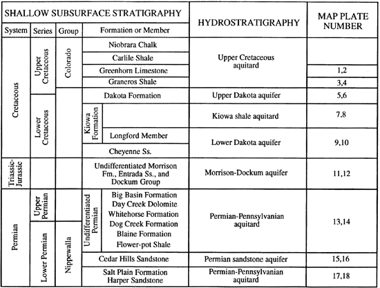
In the subsurface of southwestern Kansas the Harper Sandstone can not be distinguished from the overlying Salt Plain Formation on a gamma-ray log and thus they are considered undifferentiated. This undifferentiated unit is described as a sequence of brownish-red to reddish-brown interbedded siltstone, shale, and sandstone (Fader and Stullken, 1978). Schumaker (1966) reports finding zones of shaly, broken, halitic, anhydrite above the Stone Corral Formation in the Finney County area. Holdoway (1978) reported nodules of anhydrite in core samples from the upper part of the Salt Plain Formation in the Syracuse basin. The total thickness of this unit ranges from more than 400 ft in Clark, southern Barton, portions of Rush, and northeastern Pawnee counties to less than 100 ft in western Hamilton, Greeley, and southwestern Wallace counties. Elsewhere, In central Kansas this unit is typically 300-350 ft in thickness.
The Cedar Hills Sandstone consists of medium- to fine-grained sandstone and feldspathic sandstone with interbeds of sandy mudstone. Zones of sandstone are massive bedded for the most part, but may exhibit horizontal stratification and even high-angle cross-stratification (Holdoway, 1978). In the subsurface, the gamma-ray logs indicate that locally up to more than 90% of the Cedar Hills consists of loosely cemented sandstone. However, calcite and iron-oxide cements have been reported in the literature (Swineford, 1955). In the Syracuse basin of west-central Kansas the Cedar Hills is salt-cemented beneath thick bedded evaporites in the overlying Flower-pot Shale (Holdoway, 1978) and in parts of Meade, Clark, and Ford counties (Macfarlane, 1993). The total thickness of the aquifer ranges from more 350 ft in parts of Rush and Ness counties to less than 50 ft in northern Hamilton, northern Wichita, and southern Logan counties in the Syracuse basin.
Undifferentiated Permian strata above the Cedar Hills Sandstone include the Flower-pot Shale, the Blaine Formation, the Dog Creek Formation, the Whitehorse Formation, the Day Creek Dolomite, and the Big Basin Formation. This unit consists entirely of interbedded siltstone, shale, sandstone, and evaporites. The proportion of sandstone relative to the other clastic components increases near the Kansas-Colorado border (Maher, 1954; Maher and Collins, 1952; and Mudge, 1967). Thick bedded evaporites occur in the Flower-pot Shale and Blaine Formations in the Syracuse basin of west-central Kansas (Holdoway, 1978). The total thickness of Permian strata in this unit ranges up to more than 1,000 ft in central Hamilton County near the Syracuse basin axis. In central Kansas this unit has been beveled by pre-Cretaceous erosion and is not present.
The undifferentiated Jurassic and Triassic deposits mapping units consists of strata between the base of the Cretaceous System and the top of the Permian System. Strata within this mapping unit may belong to either the Dockum Group, the Entrada Sandstone, or the Morrison Formation. Neither the Dockum Group nor the Entrada Sandstone are officially recognized stratigraphic units in Kansas. Maclachlan (1972) describes the Dockum as consisting of distinct upper and lower portions. The lower portion of the Dockum Group consists of orange-red, fine- to medium-grained sandstone. Thin beds of coarse-grained sandstone, conglomeratic mudstone, limestone, and dolomite are common in this interval. The upper part of the Dockum consists of variegated mudstone interbedded with sandy mudstone, marlstone, limestone, dolomite, and sandstone. Limestone and dolomite pebbles are reported to be abundant at some localities. The Entrada Sandstone in Baca County, Colorado, consists of massive beds of white, friable, very fine to medium extensively cross-bedded quartzose sandstone and a few thin discontinuous layers of shale and siltstone (McLaughlin, (1954). The Morrison Formation consists of shale, sandstone, and limestone with minor amounts of chert and anhydrite (Merriam, 1955; Doveton and Chang, 1991). Two lithologic units are persistent: an upper unit which consists of sandy shale with limestone stringers and a lower unit which consists of shale with chert and anhydrite.
This mapping unit consists of strata assigned to the Longford Member of the Kiowa Formation and the Cheyenne Sandstone. The Cheyenne Sandstone is unconformable upon either Permian strata or the undifferentiated Jurassic deposits in southwestern Kansas but is conformable with the overlying Kiowa Formation (Macfarlane et al., 1990). In outcrop the Cheyenne consists predominantly of light-colored, fine- to medium-grained, friable cross-bedded sandstone (Latta, 1946). Lenses of conglomerate are common at the base of the Cheyenne and sandy to silty carbonaceous shale containing lignite are common in the upper part of the formation. The Cheyenne Sandstone crops out in parts of southern Kiowa County. In the subsurface the Cheyenne is commonly described as white, fine- to medium-grained sandstone composed of subrounded, frosted quartz grains that are unconsolidated or cemented with pyrite or calcium carbonate (Merriam, 1957). The Longford Member of the Kiowa Formation consists of interbedded sandstones, red-mottled siltstones, and mudstones in the lower part of the Kiowa Formation. Core samples of the Longford from a test-hole in SE NE Sec. 17, T. 18 S., R. 42 W., Greeley County, consist of mottled, interlaminated shale and sandstone and gray shale. Analysis of closely spaced well-logs indicates that the Cheyenne sandstone bodies are in facies relationship with coarsening upward units in the lower Kiowa (Feldman et al., in press). This mapping unit is thickest in western Lane, eastern Finney, southwestern Hodgeman, and northern Ford counties, ranging up to more than 350 ft in thickness. Nearer the Kansas-Colorado border, the thickness of this mapping unit is on the order of 100 ft.
An unnamed, thick, black marine shale makes up the bulk of the Kiowa Formation in much of western and central Kansas. The lithology of this unit includes black marine, laminated and fissile shales, thin laterally continuous (on the scale of 10-20 mi) sandstones, and discontinuous coquinoid limestones (Macfarlane et al., 1990; Feldman et al., in press)). The thickness of this marine shale facies ranges up to more than 200 ft. in northern Ford, eastern Finney, western Hodgeman, southwestern Ness, and southeastern Lane counties. Strata belonging to both the Cheyenne Sandstone and the Longford Member are in facies relationship with this marine shale facies of the Kiowa (Feldman et al., in press).
The Dakota Formation is unconformable upon Kiowa Formation deposits in southwestern Kansas, but is in facies relationship with the overlying Graneros Shale. The lithology of the Dakota is highly variable (Macfarlane et al., 1990). The upper part generally consists of variegated nonmarine claystone, fluvial through marine sandstone, lignite and shale. The lower part consists of white, gray, brown, red and tan mudstone, with claystone, siltstone and fluvial channel sandstones. Sandstones in the formation are dominantly quartz-rich (Siemers, 1971), fine- to medium-grained and constitute 25% to 40% of the formation (Keene and Bayne, 1977). Multistory fluvial channel sandstones up to 70 ft thick have been described in the central Kansas outcrop and are commonly observed on gamma-ray logs of the subsurface in southwestern and central Kansas. In the subsurface, these multistory, fluvial channel sandstone bodies may approach 100 ft thickness or more and appear to be more common in the eastern part of the mapped area than in the western part (Macfarlane et al., 1991). In southwestern Kansas outcrops of the Dakota Formation consist entirely of deposits from the upper part of the formation which consists of more marine-influenced and deltaic deposits. Dakota Formation thicknesses range up to more than 300 ft in Lane, eastern Finney, northern Gray, and eastern Ford counties. In eastern portions of the mapped area, thicknesses ranging from 250 ft to 275 ft are common where overlying strata have not been eroded. Near the Kansas-Colorado state border the thickness is usually between 250 ft and 200 ft.
The Graneros Shale consists in the lower part of medium to dark gray silty shale and shale with thin lenses of sandstone and in the upper part of medium to dark gray silty shale with lenses of calcareous sandstone and beds of Inoceramus prisms (Hattin, 1965). On gamma-ray logs the thickness of the Graneros ranges from approximately 40 ft in central Kansas to more than 150 ft in west-central Kansas in the mapped area, except where its thickness has been reduced by erosion.
Throughout most of western Kansas the Greenhorn Limestone is disconformable upon the Graneros Shale (Hattin, 1975). This is clearly demonstrated on gamma-ray logs of the subsurface by the abrupt deflection of the log trace toward lower API values, going from the shaly Graneros to the more carbonate-rich Greenhorn. In contrast, the contact of the Greenhorn with the overlying Fairport Member of the Carlile Shale is gradational. The Greenhorn Limestone consists of predominantly of dark-colored impure shaly chalk with minor chalky limestone and numerous thin seams of bentonite (Hattin, 1975). The thickness of the Greenhorn is a nearly uniform 90 ft across southwestern Kansas. However, in the subsurface of southern Trego, Ness, Rush, southwestern Hodgeman and northeastern Hamilton counties, the Greenhorn is slightly more than 100 ft in thickness.
Included in this unit are the strata assigned to the Carlile Formation, the Niobrara Chalk, and the Ogallala Formation and undifferentiated Pleistocene deposits. These formations are present in the project area but were not mapped.
The location and extent of the major tectonically-related geologic structures in the study area is presented in Figure 3 (Macfarlane et al., 1990). The major features that dominate the geologic structure of southwestern Kansas are the Central Kansas uplift, the Las Animas arch, the Western Kansas basin, and the Hugoton embayment. The Central Kansas uplift is the largest positive feature in Kansas and was a positive structural and topographic feature during the Paleozoic and possibly during a significant portion of the Mesozoic. The Hugoton embayment of the Anadarko basin plunges southward, is filled by as much as 9,500 ft. of Paleozoic, Mesozoic, and Cenozoic deposits, and was formed during the Paleozoic (Merriam, 1963). Merriam implies that the embayment may have been tectonically active during the Mesozoic. The Las Animas arch is associated with the Sierra Grande uplift in southeastern Colorado and northeastern New Mexico and was a positive structural and topographic feature that affected sedimentation during the Paleozoic (Rascoe, 1978). This uplift may have been tectonically active into the late Cretaceous (LaFerriere and Hattin, 1989) and probably received its final form by the downwarping of the Denver basin during the Laramide Orogeny (Baars et al., 1988). The Western Kansas basin is a Mesozoic feature adjacent to the Hugoton embayment and is associated with northwest tilting of the central Kansas and Nebraska areas during the late Cretaceous (Merriam, 1963).
Figure 3--Regional geologic structures in western and central Kansas and adjoining areas of Colorado, Nebraska, and Oklahoma.
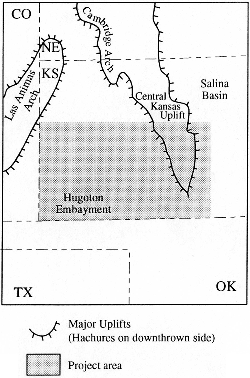
Other minor salt-solution structures are also evident on many of the top configuration and thickness maps. The Bear Creek fault zone is associated with the dissolution of bedded salt in the Flower-pot Shale and overlying Blaine Formation and the subsidence of younger strata during the Cenozoic. Smith (1940) provided evidence that the dissolution and subsidence were probably initiated in pre-Ogallala time and continued into the Holocene. A relatively recent feature, the Coolidge sink, appears to be associated with the Bear Creek fault zone (Merriam, 1963). The Scott basin and the Finney depression are related elongate synclinal structures in Scott and Finney counties, Kansas, respectively (Smith, 1940). These structures are located along the eastern edge of underlying bedded halite in the Flower-pot Shale and Blaine Formation. In the vicinity, Ladder Creek, which generally flows from west to east, abruptly changes its course to a north-south direction parallel to structure. In southern Scott County, Kansas, White Woman Creek flows into an area of interior drainage along this structural trend.
An elongate structural feature in northern Gray, Finney, and Lane counties, referred to by Merriam (1963) as a marginal syncline, is present on all of the top configuration maps for Cretaceous strata and the Permian top to west of the present eastern edge of the main salt body in the Flower-pot Shale. In the vicinity of this syncline the thickness of the Dakota and Kiowa Formations, and the Cheyenne Sandstone increases dramatically and the undifferentiated Jurassic deposits are not present. The greater thicknesses of these units combined with the evidence of subsidence in the shallow unconsolidated deposits suggests episodic dissolution of Flower-pot salt and westward migration of the dissolution front through geologic time at least since before the deposition of the Cretaceous.
The regional dip of the Mesozoic and Late Paleozoic strata is indicated on the top configuration maps and reflects post-depositional regional tilting (Merriam, 1963). The top configuration of the Dakota Formation shows that in most of Southwestern Kansas, the strata dip to the north-northeast due to the formation of the Western Kansas basin during the Cretaceous. Near the Kansas-Colorado state border, the dip is more northeasterly and is relatively steep due to Late Cretaceous-Early Tertiary uplift along the Las Animas arch and later regional north-northeast tilting.
A hydrostratigraphic unit consists of a portion of a formation, a formation, or a group of formations that forms a distinct hydrologic unit with respect to the flow of ground water (Maxey, 1964). Delineation of these units subdivides the geologic framework into relatively more or relatively less permeable portions and thus aids in flow system definition. The hydrologic behavior of any hydrostratigraphic unit is dependent in part on the properties of the adjacent units due to the refraction of flow lines at the boundary between units of differing permeability (Domenico and Schwartz, 1990). Lateral flow usually dominates within aquifers, whereas vertical flow usually dominates within aquitards. Thus, the terms aquifer, aquitard, and aquiclude are used strictly in a relative sense. In southwestern Kansas the regional hydrostratigraphic units were defined on the basis of (1) lithostratigraphy, (2) geologic history and depositional environment, (3) actual or inferred permeability or hydraulic conductivity, and (4) previous analyses of regional flow systems (Macfarlane, 1993; Macfarlane et al, 1990). From these guidelines, five aquifer and three aquitard units constitute the major hydrostratigraphic units in the shallow subsurface of southwestern Kansas (Figure 2). From deepest to shallowest they are: the Cedar Hills Sandstone aquifer, the Permian-Pennsylvanian aquitard, the Morrison-Dockum aquifer, the lower Dakota aquifer, the Kiowa shale aquitard, the upper Dakota aquifer, the Upper Cretaceous aquitard,. and the High Plains and alluvial valley aquifers. The upper and lower Dakota aquifers are distinguished because they readily yield water to wells in southwestern and central Kansas. The Cedar Hills Sandstone aquifer is distinguished because it is a thick, continuous unit and is hydraulically connected to the overlying lower Dakota aquifer in central Kansas. It is also presently used for the disposal of oil brines in much of western and central Kansas. The Permian-Pennsylvanian aquitard, the Upper Cretaceous aquitard, and the Kiowa shale aquitard are distinguished because they are believed to be significant regional confining units.
Baars, D.L., Bartleson, B.L., Chapin, C.E., Curtis, B.F., De Voto, R.H., Everett, J.R., Johnson, R.C., Molenaar, C.M., Peterson, F., Schenk, C.J., Love, J.D., Merin, I.S., Rose, P.R., Ryder, R.T., Waechter, N.B., and Woodward, L.A., 1988, Basins of the Rocky Mountain region; in, Sedimentary Cover--North American Craton, L.L. Sloss, ed.: The Geology of North America, Geological Society of America, D-2, pp. 109-220.
Domenico, P.A., and Schwartz, F.W., 1990, Physical and chemical hydrogeology: John Wiley and Sons, New York, NY, 824 p.
Doveton, J.H., and Chang, T., 1991, Latent facies mapping from binary geological data: Journal of Geology, 99, pp. 299-309.
Fader, S.W., and Stullken, L.E., 1978, Geohydrology of the Great Bend Prairie, south-central Kansas: Kansas Geological Survey, Irrigation Series 4, 19 p. [available online]
Hattin, D.E., 1965, The stratigraphy of the Graneros Shale (Upper Cretaceous) in central Kansas: Kansas Geological Survey, Bulletin 178, 83 p. [available online]
Hattin, D.E., 1975, Stratigraphy and depositional environment of the Greenhorn Limestone (Upper Cretaceous) of Kansas: Kansas Geological Survey, Bulletin 209, 128 p. [available online]
Holdoway, K., 1978, Deposition of evaporites and red beds of the Nippewalla Group, Permian, Western Kansas: Kansas Geological Survey, Bulletin 215, 43 p. [available online]
Keene, K.M., and Bayne, C.K., 1977, Ground water in Cretaceous rocks in Kansas: Kansas Geological Survey, Chemical Quality Series 5, 18 p. [available online]
LaFerriere, A.P., and Hattin, D.E.,, 1989, Use of rhythmic bedding patterns for locating structural features, Niobrara Formation, United States Western Interior: American Association of Petroleum Geologists, Bulletin, v. 73, no. 5, pp. 630-640.
Latta, B.F., 1946, Cretaceous stratigraphy of the Belvidere.area, Kiowa, County, Kansas: Kansas Geological Survey, Bulletin 64, part 6, pp. 217-260. [available online]
Maher, J.C., 1954, Lithofacies and suggested depositional. environment of Lyons Sandstone and Lykins Formation in southeastern Colorado: American Association of Petroleum Geologists, Bulletin, v. 38, no. 10, pp. 2233-2239.
Maher, J.C., and Collins, J.B., 1952, Correlation of Permian and Pennsylvanian rocks from western Kansas to the Front Range of Colorado: U.S. Geological Survey, Oil and Gas Investigations, Chart OC-46, 3 sheets.
Macfarlane, P.A., Whittemore, D.O., Townsend, M.A., Doveton, J.H., Hamilton, V.J., Coyle III, W.G., Wade, A., Macpherson, G.L., and Black., R.D., 1990, The Dakota Aquifer Program: annual report, FY89: Kansas Geological Survey Open-File Report 90-27, 301 p. [available online]
Macfarlane, P.A., Wade, A., Doveton, J.H., and Hamilton, V.J., 1991, Revised stratigraphic interpretation and implications for pre-Graneros paleogeography from test-hole drilling in central Kansas: Kansas Geological Survey, Open-File Report 91-1a, 73 p. [available online]
Macfarlane, P.A., 1993, The effect of topographic relief and hydrostratigraphy on the upper part of the regional ground-water flow system in southeastern Colorado and western and central Kansas, with emphasis on the Dakota aquifer: Ph.D Dissertation, University of Kansas, Lawrence, KS, 197 p.
MacLachlan, M.E., 1972, Triassic System; in, Geologic Atlas of the Rocky Mountain Region, W.W. Mallory, ed.: Rocky Mountain Association of Geologists, p. 166-176.
Maxey, G.B., 1964, Hydrostratigraphic units: Journal of Hydrology, 2, pp. 124-129.
McLaughlin, T.G., 1954, Geology and groundwater resources of Baca County, Colorado: U.S. Geological Survey, Water Supply Paper 1256, 232 p. [available online]
Merriam, D.F., 1963, The geologic history of Kansas: Kansas Geological Survey, Bulletin. 162, 317 p. [available online]
Merriam, D.F., 1955, Jurassic rocks in Kansas: American Association of Petroleum Geologists Bulletin, v. 39, no. 1, pp. 31-46.
Mudge, M.R., 1967, Central mid-continent region; in, Paleotectonic Investigations of the Permian System in the United States, E.D. McKee and S.S. Oriel, eds.: U,S. Geological Survey, Professional Paper 515, pp. 97-123. [available online]
Rascoe, B., Jr., 1978, Late Paleozoic structural evolution of the Las Animas arch; in, Energy Resources of the Denver Basin Symposium, J.D. Pruitt and P.E. Coffin, eds.: Rocky Mountain Association of Geologists, pp. 237-244.
Schumaker, R.D., 1966, Regional study of Kansas Permian evaporite formations: MS Thesis, Wichita State University, Wichita, KS, 87 p.
Siemers, C.T., 1971, Stratigraphy, paleoecology, and environmental analysis of upper part of Dakota Formation (Cretaceous), central Kansas: Ph.D. Thesis, University of Indiana, Bloomington, IN, 287 p.
Smith, H.T.U., 1940, Geologic studies in southwestern Kansas: Kansas Geological Survey, Bulletin 34, 212 p. [available online]
Swineford, A., 1955, Petrography of Upper Permian rocks in south-central Kansas: Kansas Geological Survey, Bulletin 111, 179 p. [available online]
Zeller, D.E., ed., The stratigraphic succession in Kansas: Kansas Geological Survey, Bulletin 189, 81 p. [available online]
Kansas Geological Survey, Geohydrology
Placed online July 12, 2010; originally released December, 1993
Comments to webadmin@kgs.ku.edu
The URL for this page is http://www.kgs.ku.edu/Hydro/Publications/1993/OFR93_1a/index.html