![]()
Prev Page--Stratigraphy--Mesozoic || Next Page--Stratigraphy--Igneous
Stratigraphy, continued
Paleozoic Rocks
Rocks of Paleozoic age in Kansas have attracted more than passing interest since their first description in the 1850s. This interest has been based not only on their richness in mineral wealth but also on their academic value for basic stratigraphic studies. The Midcontinent Permian-Pennsylvanian beds, for example, are world famous as field laboratories in the development of the science of stratigraphic geology. Many fundamental ideas have been formulated or rejected on the basis of information gained from studies of this sequence.
In Kansas, Paleozoic rocks yield large quantities of ground water, especially in the eastern part of the state. Both in eastern and western Kansas they have yielded tremendous quantities of petroleum; in fact, all commercial oil and gas in Kansas comes from these rocks (Hilpman, 1958; Goebel, 1958; Merriam and Goebel, 1959a, 1959b, 1960) except a small amount from Precambrian rocks (and that undoubtedly originated in Paleozoic rocks). The value of these resources is immeasurable (Jewett and Schoewe, 1942; Kansas Geological Survey, 1951; Schoewe, 1960). Lead and zinc deposits in extreme southeastern Kansas, although now almost exhausted, have made important contributions to the national economy. In addition to water, petroleum, lead, and zinc, the following materials in Paleozoic rocks have been or could be exploited: (1) coal (Pierce and Courtier, 1937; Whitla, 1940; Bowsher and Jewett, 1943; Schoewe, 1944, 1946, 1951, 1955, 1959; Abernathy, 1946; Abernathy, Jewett, and Schoewe, 1947; Hambleton, 1953), (2) salt (Bowdish, 1951; Runnels, Reed, and Schleicher, 1952; Kulstad, 1959), (3) gypsum (Kulstad, Fairchild, and McGregor, 1956), (4) limestone (Runnels, 1951; Runnels and Schleicher, 1956; Ives and Runnels, 1960), (5) building stone (Risser, 1960), (6) germanium (Schleicher and Hambleton, 1954; Schleicher, 1959), (7) phosphate (Runnels, 1949), (8) uranium (Runnels, Schleicher, and Van Nortwick, 1953), (9) cement (Runnels, 1959), (10) lightweight aggregate (Plummer and Hladik, 1951), (11) riprap, etc. (Kulstad and Nixon, 1951), and (12) asphalt (Jewett, 1940).
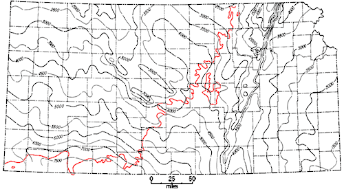
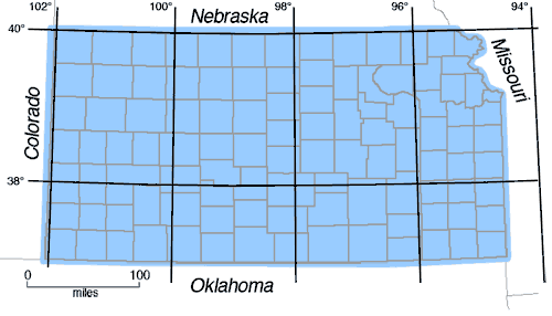
Rocks of Paleozoic age, in downward succession as shown by well penetrations, belong to the Permian, Pennsylvanian, Mississippian, Devonian, Silurian, Ordovician, and Cambrian Systems (Fig. 2). Although all Paleozoic systems are represented in Kansas, many of the series are absent or only very incompletely developed. As will be explained later in detail, much of geologic time is not represented by rock deposits in Kansas. Permian rocks are limited to the western four-fifths of the state; the Pennsylvanian has virtually statewide distribution. Both Permian and Pennsylvanian units consist mainly of thin-bedded, alternating marine and nonmarine deposits. Covering much of the state, except on uplifted areas, is the mainly carbonate sequence of beds of Mississippian age. This division of the Paleozoic is relatively thick, especially in basinal areas. Silurian-Devonian rocks are restricted to northcentral and northeastern Kansas and have a thickness much less than that of the older Cambrian-Ordovician rocks. The Silurian-Devonian Systems have the smallest areal distribution of major units. Cambrian-Ordovician rocks overlie Precambrian everywhere except on higher parts of uplifts where they have been removed by erosion and younger deposits rest directly on the basement complex. These strata attain considerable thickness in southwestern Kansas (Fig. 31).
Figure 31--Map showing thickness of Paleozoic rocks in Kansas. Area northwest of [red] line is buried beneath Mesozoic deposits. Contour interval 500 feet. A larger version of this figure is available.
Paleozoic rocks nonconformably overlie the Precambrian everywhere in Kansas. They are unconformably overlain by Mesozoic or Cenozoic deposits or are exposed at the surface. Beds older than Mississippian are not exposed in Kansas; Pennsylvanian and Permian beds are well exposed in the eastern third of the state except in the northeast comer, where they are covered by glacial deposits.
Pre-Pennsylvanian rocks in the state are mainly shelf-type marine sediments consisting of limestone and dolomite and some shale and sandstone. Salt, gypsum, coal, underclay, and black shale are locally important and abundant in the Pennsylvanian and Permian. Unconformities are common and widespread in the Paleozoic section. Major unconformities occur between: (1) Mesozoic and Paleozoic, (2) Pennsylvanian and Mississippian, (3) Mississippian? and Devonian, and (4) Paleozoic and Precambrian. Many disconformities in the Permian-Pennsylvanian part of the section are marked by channel sandstones. Disconformities are numerous, owing to the conditions controlling deposition of the sediments. The end of the Paleozoic is marked by a complete change in depositional and structural conditions.
A complete list of publications dealing with the Paleozoic in Kansas would contain almost everything written about the geology of the state, and is far beyond the scope of this report. Moore (1935b), in a comprehensive paper, listed work up to that time concerning Pennsylvanian rocks of Kansas, and the list is indeed extensive. In 1949 he gave further information on the Pennsylvanian rocks in Kansas. Recent information on the Permian may be obtained from Swineford (1955) and Dunbar and others (1960). Because the Pennsylvanian and Permian crop out in eastern Kansas, more information is generally available concerning them than the other Paleozoic units. General references for the Paleozoic rocks of Kansas may be obtained from Moore and others (1951a).
Some of the more important recent papers pertaining to stratigraphy of the Pennsylvanian and Permian include: Bass (1936), Branson (1962), Hattin (1957), Howe (1956), Jewett and Newell (1935), Jewett (1945), Lane (1958), Laporte (1962), Lins (1950), Moore (1940, 1948, 1957b), Moore and Merriam (1959), Moore and Mudge (1956), Moore and Thompson (1949), Moore and others (1944), Mudge (1957a, 1957b), Newell (1935), Norton (1939), O'Connor and Jewett (1952), Rascoe (1962), Thompson (1944), Wagner (1954), Wagner and Harris (1953), and Winchell (1957). Early works include those by Adams, Girty, and White (1903), Cragin (1896a, 1897), Haworth (1894, 1895), Haworth and Bennett (1908), Meek and Hayden (1859), Mudge (1866), Prosser (1895, 1902, 1905), and Swallow (1866, 1867). In recent years the State Geological Survey of Kansas has issued several county reports that concern Permian-Pennsylvanian rocks (Jewett, 1941a; Moore and others, 1951b; O'Connor, 1960; O'Connor and others, 1953, 1955; Verville and others, 1958; K. L. Walters, 1953, 1954).
Publications dealing with Paleozoic rocks include: Barwick (1928), Byrne and others (1958), Clair (1948), Collins (1947), Dott (1941), Edson (1945, 1947), Elias (1937a, 1937b), Keroher and Kirby (1948), Kellett (1932), Koester (1935), Leatherock (1945), Lee (1939, 1940, 1943, 1949, 1953, 1956), Lee and Merriam (1954b), Lee, Leatherock, and Botinelly (1948), Lee and others (1946), McClellan (1930), McCracken (1955), Maher (1946, 1947), Maher and Collins (1949), Merriam and Atkinson (1956), Mudge and Burton (1959), Mudge, Matthews, and Wells (1958), Mudge, Walters, and Skoog (1959), and Ockerman (1935).
Present structure on different Paleozoic rock units of Kansas is shown on maps by Merriam (1958b, 1960b), Merriam and Kelly (1960), Merriam and Smith (1961), and Merriam, Winchell, and Atkinson (1958).
Permian Deposits
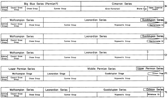
The Permian is subdivided into two series by the Federal Geological Survey, into three by Moore (1958) and Jewett (1959), and into four by Moore and others (1951a) and by Dunbar and others (1960). [Note: The Geologic Names Committee of the U.S. Geological Survey reported (June 30, 1960) "The Chief Geologist has approved the recommendation of the Geologic Names Committee that a twofold subdivision of the Permian system and period be adopted for use by the U.S. Geological Survey. The divisions (Lower and Upper series and Early and Late epochs) are to coincide as nearly as possible with those recognized in the type Permian and are to be drawn according to existing concepts of biotal correlation with the type sequence. The reference sequence for the United States shall be the Permian outcrops of northwestern Trans-Pecos Texas (Delaware Mountains, Guadalupe Mountains, and Sierra Diablo Mountains), where the approximate faunal boundary is taken as that between the Cherry Canyon and Bell Canyon formations."] It is deemed advisable to follow Moore and others (1951a) until the nomenclature is stabilized. [Note: The Kansas Survey recendy returned to essentially the classification used three decades ago by proposing Gearyan for pre-Wellington beds and Cimarronian for all younger Permian rocks in Kansas (O'Connor, 1963).] Actually it makes little difference whether a time-stratigraphic unit is treated as a series or a stage or is given another rank in the hierarchy, as long as the reasons are understood for placement at a particular level.
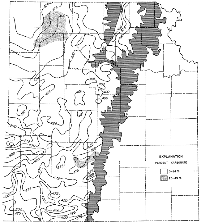
Three of the four series are recognized in Kansas (in descending order): rocks of Ochoan are not represented, Guadalupian, Leonardian, and Wolfcampian. Post-Wolfcampian beds are mainly redbeds and evaporite deposits. Wolfcampian strata are very similar to and gradational with the underlying Pennsylvanian beds; indeed, the contact chosen as the boundary has been changed repeatedly. Permian rocks are present in the western four-fifths of the state (Fig. 32) and crop out in a wide band extending across Kansas from the northeastern to the south-central part. Wolfcampian beds, many of them cherty, are exposed in and give name to the well-known Flint Hills.
Figure 32--Map of Kansas showing surface and subsurface distribution of Permian rocks.
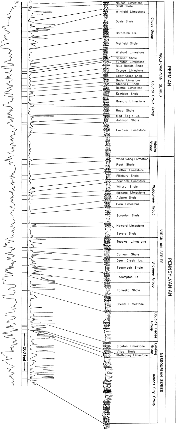
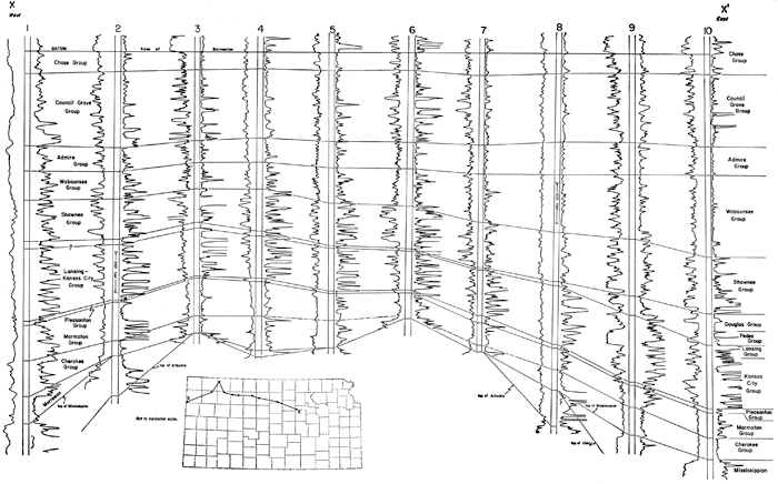
The Wolfcampian in Kansas, consisting (in descending order) of the Chase, Council Grove, and Admire Groups, is mainly an alternation of thin shale and limestone units (Fig. 33, 34). These are traceable for long distances in Kansas and neighboring states, and they exhibit cyclic characteristics similar to those of beds in the upper part of the Pennsylvanian System (Jewett, 1933). Conformably overlying lower Permian rocks is a sequence of shale, siltstone, and sandstone, most of which is predominantly red, interbedded locally with relatively thick deposits of salt, gypsum, anhydrite, and dolomite (Fig. 35). In these beds are recognized 9 formations bundled into 2 groups and 3 formations not assigned to a group, which are classified in the Leonardian and Guadalupian Series.
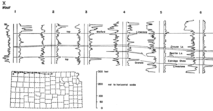
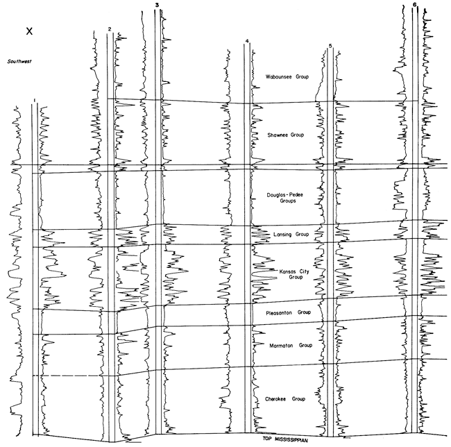
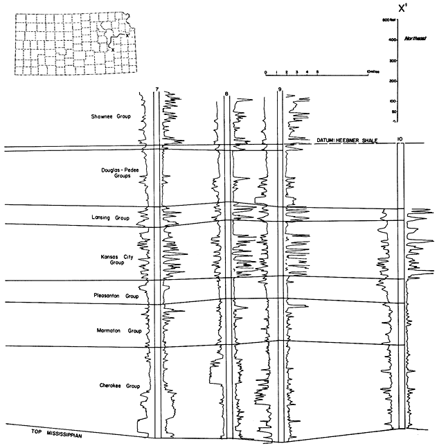
Figure 33--West-east electric-log cross section in northern Kansas showing relation of Permian units to each other and to adjacent beds. A larger version of this figure is available, as is an Acrobat PDF version (852 kB).
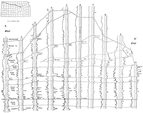
Figure 34--Northwest-southeast electric-log cross section in northwestern Kansas showing relation of Permian units to each other and to adjacent beds. A larger version of this figure is available, as is an Acrobat PDF version (670 kB).
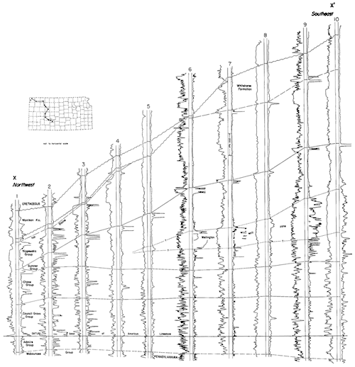
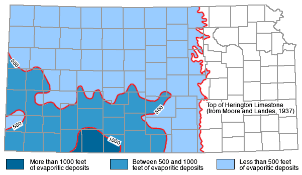
Figure 35--Map of Kansas showing total thickness of evaporitic deposits in Permian redbed sequence. Maximum thickness is about 1,400 feet in Clark County. Contour interval 500 feet.
Redbeds in Kansas received much attention from early workers and were at various times included in the Permian, Triassic, Jurassic, and Cretaceous Systems before the classic publication by Cragin in 1896. He regarded the redbeds as Permian in age, and his classification of these sediments still serves as a basis for stratigraphic work. Many papers on the redbeds appeared in the late 1800s and early 1900s, of which those by Cragin (1896a, 1897), Grimsley and Bailey (1899), Hay (1889, 1891), Prosser (1897, 1902), and St. John (1887) should be mentioned. Other papers on the redbeds in Oklahoma and Texas were written about this same time and a little later.
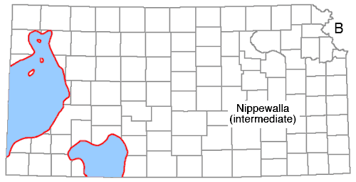
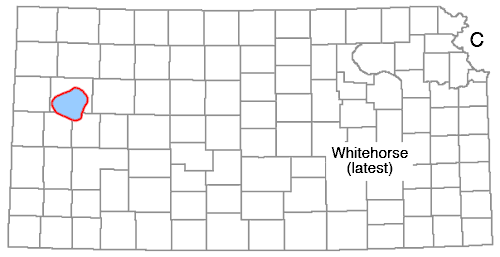
The uppermost beds of the Permian System are not presently grouped into larger rock units, although several names have been used for part or all of this sequence, including Whitehorse Group, Quartermaster Group, and upper Cimarron. The three formations not assigned to a group are (in descending order): "Taloga Formation," Day Creek Dolomite, and Whitehorse Formation--in other words, all Permian rocks in Kansas above the Dog Creek Formation.
Distribution--The units are confined to the southwestern part of the state. Each of the formations crops out in south-central Kansas in Clark and Meade Counties and southwestern Kiowa County.
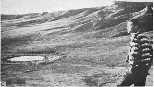
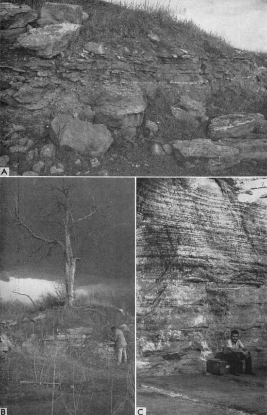
Character--The "Taloga" is mainly a red-brown, anhydritic, silty shale that forms rolling hills (Pl. 12C). [Note: According to Robert O. Fay (personal communication), beds in Kansas termed "Taloga" have been miscorrelated with the type Taloga of Oklahoma, which is actually older. This being the case, another stratigraphic term for the Kansas "Taloga" is necessary, ond Big Basin has been suggestod (O'Connor, 1963).] The Day Creek is a fine-grained, dense, locally oolitic dolomite on the outcrop, but in the subsurface it may be dolomitic anhydrite or anhydritic dolomite. The change is similar to the surface-to-subsurface change described for the Stone Corral Formation. The underlying Whitehorse is reddish-brown, anhydritic, silty mudstone and shale, siltstone, and sandstone. In the subsurface the group may be distinguished from the overlying, more brightly colored Triassic by its brownish color; and it differs materially from the greenish-gray, anhydritic or limy shale of the Jurassic and the brown sandstones or black shales of the Cretaceous.
Plate 12C--"Taloga Formation" (Permian) capped by Ogallala "mortar beds" in Big Basin, Clark County (sec. 25, T. 32 S., R. 25 W.).
Thickness--In Kansas the thickness of these upper Permian units ranges from a featheredge to a maximum of slightly more than 700 feet in the southwestern corner. The "Taloga" ranges in thickness to about 300 feet, the Day Creek to 65 feet, and the Whitehorse to 400 feet. Inasmuch as the upper boundary of the Permian is defined by an erosion surface, thickness of the strata varies with configuration of the surface, but in general it decreases to the north and east. On the outcrop, thicknesses of the "Taloga," Day Creek, and Whitehorse are about 45, 2, and 270 feet, respectively.
Stratigraphic Relations--The formations are conformable with each other, and the Whitehorse is conformable with underlying beds of the Nippewalla Group. The upper contact, as previously mentioned (Fig. 36), is an erosional one. The upper part of the succession is locally leached of its red color, especially where the beds are sandy.
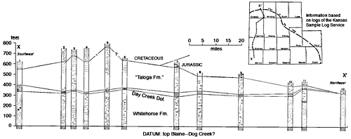
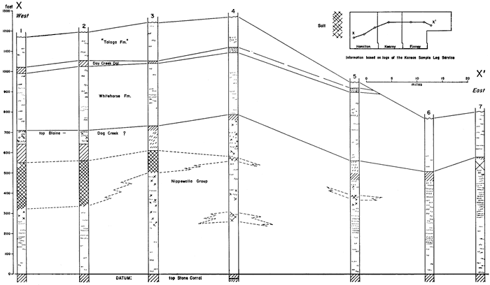
Figure 36--Southwest-northeast cross section showing stratigraphic relations of beds in upper Permian in southwestern Kansas. Note uniform thickness of Whitehorse Formation, lateral persistence of Day Creek Dolomite, which is mostly anhydrite, and northward thinning of "Taloga Formation" by post-Permian erosion. A larger version of this figure is available, as is an Acrobat PDF version (430 kB).
The Nippewalla Group is a thick sequence of redbeds between the overlying Whitehorse Formation and the underlying Sumner Group. The Nippewalla is composed of six formations (in descending order): Dog Creek Shale, Blaine Formation, Flowerpot Shale, Cedar Hills Sandstone, Salt Plain Formation, and Harper Sandstone.
Distribution--The Nippewalla Group extends over approximately the western one-half of Kansas. Beds of the group are exposed in south-central Kansas, where they strike approximately north and dip gently westward. This strike changes to about northwest near the middle of the state, where the beds are concealed under a cover of younger, mainly Cretaceous, beds.
Character--A variety of rock types makes up this group, including silty shale, siltstone, very fine grained sandstone, dolomite, gypsum, and salt, truly a sequence of redbeds. Two of the formations are sufficiently distinct to be recognized with certainty in the subsurface, the Blaine Formation and Cedar Hills Sandstone. With sufficient study it might be possible to differentiate the other formations according to their lithologic characteristics.
The Blaine, probably anhydritic gypsum, or locally entirely anhydrite, gives a very characteristic "kick" on electric logs and may be recognized easily in samples. With caution, it possibly could be used as a shallow structural marker bed (Donald J. Malone, personal communication). The Cedar Hills is sufficiently porous to be used as a shallow disposal zone for oilfield brine.
Several salt beds in this part of the stratigraphic section are restricted to the subsurface of parts of western Kansas (Fig. 37). Although their distribution and thickness are not precisely known at present, they are important for many reasons, especially for their possible use for underground storage of liquefied petroleum gases and other fluids (Jewett and Goebel, 1960) and for their effect on velocity computations in seismic exploration (Glover, 1959). Distribution of Nippewalla salt deposits is shown in Figure 37.
Figure 37--Subsurface distribution of A, Hutchinson Salt in Wellington Formation, Sumner Group (Kulstad, 1959); B, salt in Nippewalla Group; and C, salt in Whitehorse Formation.
Thickness--The exact thickness of the group is not known with certainty, but in places it is at least 1,000 feet and may be much more. Generally speaking, the units are thinnest along the outcrop and thickest near the deeper part of the Hugoton Embayment. Moore and others (1951a) gave the following approximate thicknesses on the outcrop: Harper, 220 feet; Salt Plain, 265 feet; Cedar Hills, 180 feet; Flowerpot, 190 feet; Blaine, 50 feet; and Dog Creek, 53 feet.
Stratigraphic Relations--The exact stratigraphic relations of the units to each other and to adjacent units are not definitely known, but it is believed that they are conformable. An interesting feature shown on Figure 38 is the facies change of the Nippewalla salt zone, which lies just below the Blaine-Dog Creek? beds. A "solid" salt bed in the west becomes anhydritic eastward, then all anhydrite, and finally passes laterally into clastic sediments. This same sequence from "solid" salt to clastics can also be seen grading downward. It is important to note that the presence of the salt does not increase stratigraphic thickness.
Figure 38--Cross section in southwestern Kansas showing stratigraphic position of salt in Nippewalla Group in Permian redbed sequence. Where not possible in subsurface to differentiate Dog Creek, which is stratigraphic top of Nippewalla, top of Blaine is shown. Note lateral equivalent of "solid" salt. A larger version of this figure is available.
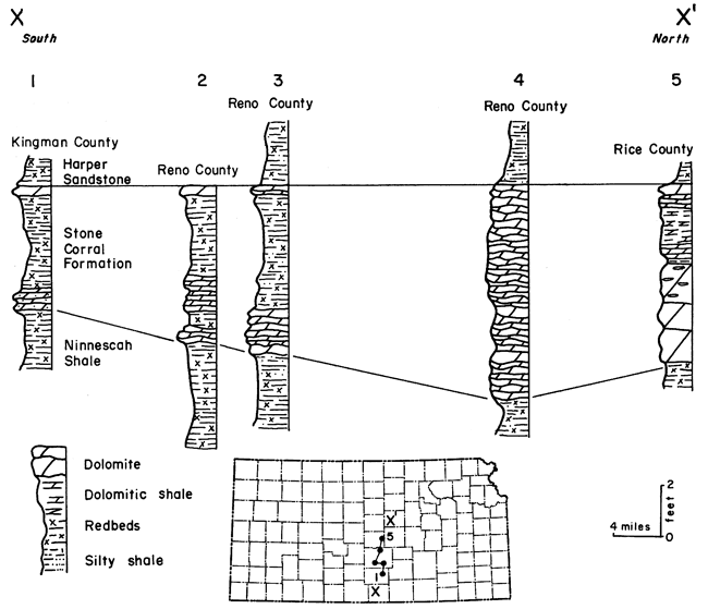
The Sumner Group, between the overlying Nippewalla Group and the underlying Chase Group, comprises three formations (in descending order): Stone Corral Formation, Ninnescah Shale, and Wellington Formation. The Sumner, like previously mentioned groups, consists mainly of redbeds and evaporites. The Stone Corral Formation (Pl. 13A, 13B) and the Hutchinson Salt Member of the Wellington Formation (Pl. 13C) are two stratigraphically important units. The Stone Corral is noteworthy enough to warrant special mention and will be discussed in more detail than other units.
Plate 13--A, Type section of Stone Corral Formation (Permian), Rice County (sec. 11, T. 20 S., R. 6 W.). B, Quarry exposure of about 6 feet of dolomite constituting the Stone Corral Formation on outcrop, Rice County (sec. 11, T. 20 S., R. 6 W.). C, Hutchinson Salt Member of Wellington Formation in Carey Salt Mine, Hutchinson, Reno County.
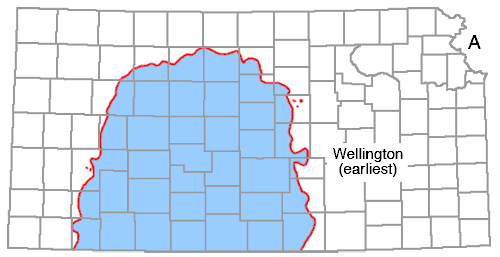
Distribution--Rocks of the Sumner Group cover about two-thirds of Kansas. Both the redbeds and the underlying nonred strata (Wellington) dip gently westward into the subsurface from the outcrop, which extends from Sumner County on the south to Washington and Marshall Counties on the north. On the whole, the group is poorly exposed.
Character--The group consists mainly of silty shale; limestone, dolomite, anhydrite, gypsum, and salt, although minor in amount, are important economically and as stratigraphic markers. The lower part of the Wellington Formation is gray shale, and no thick redbed sequence occurs below it. Distribution of the Hutchinson Salt is shown in Figure 37. Other salt beds are known to occur in the Sumner Group, but their exact limits are not known at present. The Hutchinson Member is the most widespread and thickest of the salt deposits found in Kansas and is mined in several areas where near the surface. The salt does not crop out, owing to its solubility, and along the area where it has been dissolved, the overlying beds are badly slumped. Recognition of the occurrence of this solution and the subsequent collapse of overlying units is extremely important in mapping and interpreting structure.
Thickness--Moore and others (1951a) state the thicknesses of the Wellington along the outcrop to be about 700 feet, Ninnescah Shale about 300 feet, and Stone Corral about 6 feet. Kulstad (1959) has shown the Hutchinson Salt Member of the Wellington to be as much as 700 feet thick in the subsurface of Clark County; thus, the total thickness of the Wellington must be appreciably more than 700 feet in southwestern Kansas.
Stratigraphic Relations--An important unconformity is now recognized at the base of the Stone Corral (Fig. 33 and 34), although the other units are believed to be conformable with each other and with overlying and underlying units.
In the Permian redbed section, which is about 1,900 feet thick, few beds can be traced very far laterally; the Stone Corral is one formation that is persistent over a large area. Because it is easily identifiable in well samples and on electric and radioactivity logs, and because it lies at shallow to moderate depth under much of Kansas, it serves as an important marker for structural and stratigraphic work. This unit often is used as a datum for core-hole drilling and also serves as a good reference layer for reflection seismograph work (Glover, 1953; Pakiser, Mabey, and Warrick, 1954).
Cragin (1896a, p. 17, 18) seemingly was the first to notice the dolomite (Stone Corral) that crops out in south-central Kansas, and he included this bed in his "Wellington shales":
The massive ledge of hard, cellular, gray dolomite on the Little Arkansas river at the eastern border of Rice county, west of south from Windom, is provisionally referred to the Wellington formation.
Norton (1939) named and described in detail the Stone Corral dolomite-anhydrite. He first proposed the name in 1935, and it was used more or less informally by Koester (1935), Norton (1937), and Green (1937). Norton (1939, p. 1777) stated:
Credit for first recognizing the correlation of the subsurface "Cimarron Anhydrite" with the outcropping Stone Corral at its type locality and in the adjacent Welch pool, goes to William L. Ainsworth, of Wichita, Kansas, who established this correlation after core-drilling to the dolomite marker in Rice County, and so informed the writer in 1929.
The name "Stone Corral" was first applied to this dolomite by the writer in a preliminary abstract of this paper published in the program of the March 21, 1935, annual meeting of the American Association of Petroleum Geologists at Wichita, Kansas, where it was read by title, the paper itself being presented before the Kansas Geological Society at Wichita, Kansas, April 17, 1935, and this name has since been used by Koester and Green, using the writer's section. . . .
The name comes from an old stone corral that was built for protection from the Indians along the Santa Fe Trail near a ford on Little Arkansas River north of Wichita. Because of the diverse lithologies found within the formation, Lee (1953, p. 6) proposed that the descriptive term "dolomite" be dropped and "formation" substituted. This suggestion was followed by Lee and Merriam (1954a) when they referred to the Stone Corral Formation.
Surface--The Stone Corral Formation consists of dolomite, anhydrite, shale, and minor amounts of salt and gypsum. At the type locality, in sec. 11, T. 20 S., R. 6 W., in Rice County, the formation is almost entirely dolomite and dolomitic shale (Fig. 39; Pl. 13A). In this area the formation is 6 feet thick and forms a low escarpment. The surface of the upper dolomite bed is ripple marked. Swineford (1955, p. 47) described the exposure as follows:
. . . The dolomite is dense to cellular, and grayish buff in color. It contains many vugs partly or completely filled with coarsely crystalline calcite or gypsum. The basal one-third is in part oolitic, with individual oolites up to one-half mm in diameter. Large oolites (1 mm diameter) also occur 2 feet below the top. The top 2 inches, also localIy oolitic, is in part pink. The material of the oolites is more soluble, under ordinary conditions of weathering, than that of the matrix.
Tracing this bed to the south along the outcrop reveals that the thickness of dolomite decreases and the amount of shale increases to such an extent that in Kingman County the formation is hardly recognizable (Fig. 39). Farther south, in Harper County, Swineford (1955, p. 49) reported that the formation is represented only by scattered dolomite rhombs in silty shale.
Figure 39--Correlation of surface outcrops of Stone Corral Formation in south-central Kansas; datum is top of Stone Corral. Note that formation becomes more shaly southward, and massive dolomite beds present at type locality (sec. 11, T. 20 S., R. 6 W.) are not recognizable (from Merriam, 1957a).
Norton (1937, 1939) recognized the existence of a disconformity between the Stone Corral and underlying shale, based chiefly on the presence or absence of a wedge of maroon shale that occurs between the Runnymede Sandstone Member of the Ninnescah Shale and the Stone Corral. He also believed that the presence or absence of gypsum beds at the top of the formation indicates a disconformity at the top of the Stone Corral. Maher (1946) also found some evidence of a minor unconformity above the Stone Corral in the subsurface.
According to Norton (1939, p. 1779), no fossils have been found in the Stone Corral, but fragmental carbonized wood occurs in a core from Stafford County. The fossil Cyzicus ("Estheria") occurs in some beds near the middle of the underlying Ninnescah Shale. Also, some fossils have been reported from the Whitehorse in Oklahoma (Gould, 1901). Newell (1940) reported that the Whitehorse fauna includes Dielasma, Composita, Schizodus, Pleurophorus, Edmondia, Allorisma, Parallelodon, Conocardium, Pernopecten, and Pseudamusium?, indicating a normal marine environment. In addition to these brachiopods and pelecypods there are bryozoans and gastropods. These invertebrates, plus a few known vertebrates, definitely indicate Permian age of beds at least this high in the column. This, of course, would include the Stone Corral Formation, because it lies stratigraphically below the Whitehorse.
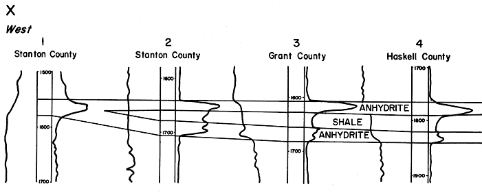
Subsurface--A short distance downdip from the outcrop of the Stone Corral, the formation consists almost entirely of anhydrite. To the south, in an area comprising parts of Reno, Kingman, Harper, Barber, and Comanche Counties, the Stone Corral is represented by anhydritic or dolomitic shale (Fig. 40). Farther west and throughout a considerable part of western Kansas, the unit consists of pure to dolomitic anhydrite, or it includes a dolomite bed in the lower part or at the base of the formation. In southwestern Kansas in an area covering parts or all of 21 counties, the formation is split into two anhydrite beds separated by red shale (Fig. 41). The lower anhydrite is dolomitic in most places and is less extensive than the upper bed. The shale in parts of Meade, Seward, Stevens, Haskell, Finney, Lane, Scott, and Logan Counties is saliferous. In Logan and Thomas Counties the anhydrite is locally saliferous. In the subsurface the formation is underlain and overlain by beds of red silty shale and shaly sandstone. A gypsiferous red shale is present above the Stone Corral in some areas, whereas in others a salt-bearing shale is present below the formation.
Figure 40--Generalized surface and subsurface distribution of lithologic types in Stone Corral Formation. North of Rice County, eastern limit of formation is covered by later deposits, whereas formation crops out discontinuously south of east-central Rice County (from Merriam, 1957a). A larger version of this figure is available.
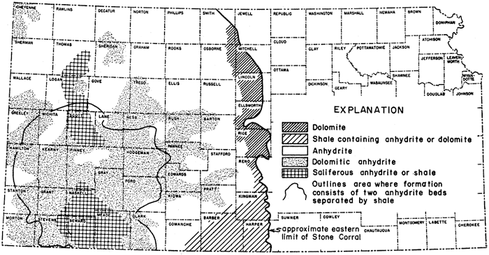
Figure 41--West-east electric-log cross section of area in southwestern Kansas where Stone Corral ("Cimarron anhydrite" of subsurface terminology) consists of two anhydrite beds separated by red silty shale. Datum is top of uppermost anhydrite bed. To west and east the formation has characteristic "kick" on logs and consists of one bed of anhydrite (from Merriam, 1957a). A connected version of this figure is available.
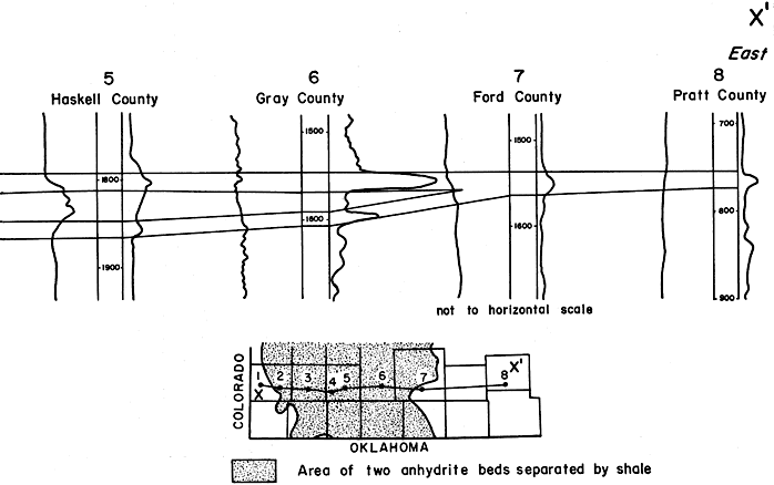
Because the Stone Corral is composed mostly of anhydrite in the subsurface, and also was named Cimarron, it is commonly called the "Cimarron anhydrite." Most of this anhydrite is pinkish white or white mottled gray, massive, and crystalline. It may be finely crystalline and have a sugary texture. Rarely present is a thin limestone. Most of the shale is silty and red, although gray shale is not uncommon.
Several explanations can be offered for the lithologic change of the Stone Corral between the surface and subsurface (Merriam, 1957a). Anhydrite may have been leached by surface waters, leaving the less soluble dolomite at outcrops; whether anhydrite was formerly interbedded with the dolomite or was above it is not known, however. Possibly the dolomite is the same bed that in the subsurface forms the base of the formation and lies below the anhydrite, and the upper part of the formation does not crop out. Another possibility is that the facies may change between the outcrop and the subsurface. Furthermore, it is possible that the anhydrite was never deposited as far east as the present outcrop of the dolomite, and thus never was present in Rice, Reno, Kingman, and Harper Counties. Considering all known evidence, a logical explanation is that the upper part of the formation, which consists of anhydrite, has been leached on the surface and thus does not crop out. The outcropping dolomite, then, probably represents the dolomite bed at the base of the formation in the subsurface.
The thickness of the Stone Corral in the subsurface is generally between 25 and 45 feet. In southwestern Kansas, however, in Gray, Finney, Kearny, and Grant Counties, the maximum thickness of the formation, 90 to 100 feet, was deposited near the center of the area in which the formation consists of two anhydrite beds separated by shale. It seems that this area was near the center of the depositional basin.
By means of samples and electric and radioactivity logs, it is possible to trace the Stone Corral into the adjacent states of Nebraska, Colorado, New Mexico, and possibly Oklahoma. Maher (1948) remarked that because of its irregularity and because of the presence of other unnamed anhydrite beds, the Stone Corral is not so easily identified in eastern Colorado as in western Kansas. He was able, however, to trace the unit to the Front Range in Colorado, where he correlated it with the "contact limestone" at the top of the Fountain Formation (Maher, 1953a, p. 921).
Environment of Deposition of Redbeds
Swineford (1955, p. 164) has summarized nicely the interpretation of the origin of these deposits, and part of her summary is presented here.
. . . The general picture of the area in post-Wolfcampian Permian time is one of a broad, shallow, fairly stable basin, bounded on the west by the Front Range and Wet Mountains, which supplied most of the feldspathic debris. . . .
On the north and east the Permian basin was probably bounded by low-lying land areas which supplied little or no debris. To the south of the Anadarko basin was a restricted connection with the open sea, and several local uplifts which formed islands of mountain ranges, such as the Arbuckles, the Wichitas, and possibly intermediate mountains. Other possible land areas are the Ozark uplift and the Ouachita system.
It is thought that the source of the large rounded quartz and chert grains was in the Cambro-Ordovician orthoquartzitic sediments that underlay the entire area and were exposed to erosion locally in the isolated uplifted areas. Such a wide-spread source would account for the ubiquitous distribution of these grains.
Almost no clastics coarser than silts reached the Kansas outcrop area before Cedar Hills time, when numerous wide-spread very fine sandstones were deposited. Cedar Hills deposition was followed by another period of extremely fine clastic supply, and the Flowerpot shale was deposited in quiet water rich in calcium and sulfate ions. This episode culminated in deposition of wide-spread evaporite deposits (Blaine gypsum-anhydrite). An influx of fine feldspathic sand, perhaps both from the west and south, produced the Whitehorse formation. The supply of medium-grained clastic material gradually diminished during Whitehorse time, and montmorillonitic (bentonitic?) clays were deposited, as was also a thin persistent dolomite (Day Creek). The poorly sorted sands and silts of the Taloga formation suggest the incidence of slight instability and perhaps the deposition of poorly reworked flood-plain materials before the Permian seas withdrew entirely from the area.
Age and Correlation of Permian Redbeds
The precise age and correlation of the Permian redbed sequence in Kansas are far from settled. Within the last two decades the classification of these beds has been changed by the Kansas Survey four times, although only one major publication dealing with them was published in this period (Swineford, 1955). Swineford (1955, p. 21) concluded that "The problem of correlation of nonfossiliferous red clastics in Kansas with a type marine section in west Texas seems almost insurmountable. . . ."
Dunbar and others (1960, p. 1789) have reported the following: "The Nippewalla and Whitehorse groups of Kansas and Nebraska, and their equivalents in Oklahoma, are virtually unfossiliferous. Correlations are therefore based on physical stratigraphy. They are related to the section in central Texas by surface tracing and to the exposures in Colorado and Wyoming by subsurface correlation under the Great Plains. It is impossible to reconcile some of the conflicting opinions. . . ."
Figure 42 shows the differences in interpretation of the Permian redbeds in Kansas as compared with the previously recognized subdivisions that appeared on the Geologic Map of Kansas (Moore and Landes, 1937). The rock unit boundaries have remained stable since 1944, although several names have been used (or none at all) for the sequence above the Nippewalla Group. Not so for the Leonardian, Guadalupian, and "Ochoan" boundaries, which have moved up and down. It seems desirable to reach some agreement concerning these beds so that their nomenclature in the Kansas region can be stabilized.
Figure 42--Chart showing Permian rock classifications used in Kansas during the last 25 years. Even more changes are being considered. A, Moore and Landes (1937); B, Moore, Frye, and Jewett (1944); C, Moore and others (1951a); D, Moore and others (1952); E, Jewett (1959); F, Dunbar and others (1960). A larger version of this figure is available.
Lower Permian rocks, as classified in Kansas, belong to three groups of the Wolfcampian Series (in descending order): Chase, Council Grove, and Admire. Because they are similar in character, it is convenient to treat them together. The overall thickness of the three groups is about 800 feet.
Seven alternating (cyclic), predominantly shale-and-limestone formations compose the Chase Group, which conformably overlies the Council Grove Group. Many of the units are distinctive enough to be recognizable in the subsurface. The shales are mostly red and green or varicolored, and most of the limestones are cherty. In the lower part of the group, three members--Florence Limestone Member of the Barneston Limestone (Pl. 14A) and Threemile Limestone and Schroyer Limestone Members of the Wreford Limestone (Pl. 14B, 14C)--contain a great abundance of chert (flint). It is mainly from these scarp-forming, prominent beds that the Flint Hills derive their name. Some of the limestones in the upper part of the Chase are somewhat dolomitic and many are characterized by the occurrence of concretions and geodes. The base of the Barneston Limestone is one of the obvious, persistent stratigraphic boundaries that can be traced on electric logs as well as lithologic logs.
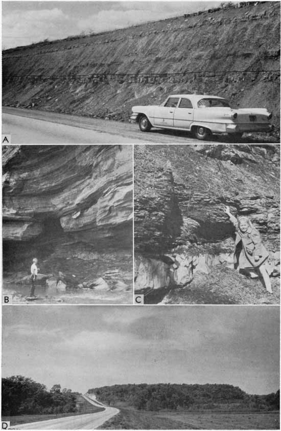
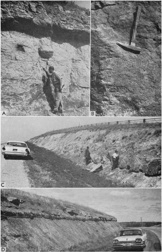
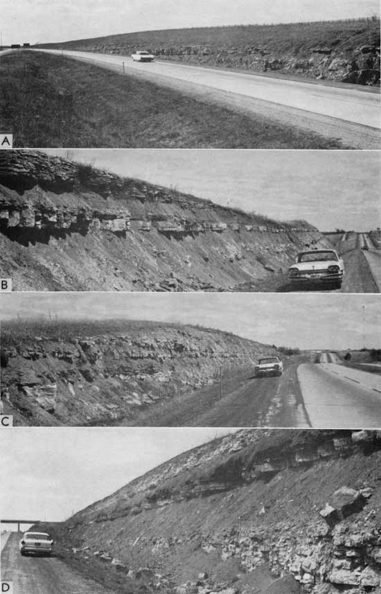
Plate 14--A, Deep road cut in Florence flint on U.S. Highway 40 about 7 miles east of Junction City, Geary County. B, Clam borings in Wreford Limestone on Kansas Highway 38, Cowley County (sec. 29 and 30, T. 32 S., R. 7 E.). C, Chert in Wreford Limestone about 2 miles north of intersection U.S. Highway 40 and Kansas Highway 13, Riley County. D, Florena Shale (above) and Cottonwood Limestone (below) about 1 1/2 miles southwest of Manhattan, Riley County (NW SE sec. 23, T. 10 S., R. 7 E.).
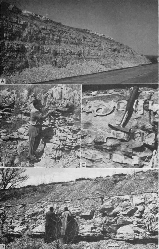
The Council Grove Group underlies the Chase Group and conformably overlies the Admire Group. It comprises 14 formations, all of which can be recognized with some certainty in the subsurface. Like the Wabaunsee (Upper Pennsylvanian) and Admire Groups, the Council Grove is mostly shale, but it contains a greater percentage of limestone than the other mentioned groups. Considering the Council Grove as a whole, it contains more varicolored and red shales than do the underlying units, and the limestones contain more chert. The presence of chert in some of these beds was an important factor aiding Moore and Merriam (1959, p. 28) to recognize the megacyclic nature of this part of the sequence. Several limestone units are distinctive lithologically--for example, the Cottonwood Member of the Beattie Limestone (Pl. 14D), Neva Member of the Grenola Limestone, and Americus Member of the Foraker Limestone. Both the Cottonwood and Americus are fusulinid-bearing limestones; so abundant are the fusulinids, as a matter of fact, that they are an important lithologic constituent and the units may be identified in sequence on this aspect alone. In addition to having lithologic attributes that may be identified in samples, the Cottonwood, Neva, and Americus Limestones, in contrast to adjoining beds, form conspicuous "kicks" on electric logs. Some evaporite deposits also are found in the Council Grove Group, although they are relatively minor in amount. Most of the Council Grove units are traceable westward into Colorado.
The Admire Group consists chiefly of shale but includes some thin limestones, of which the Five Point Limestone may be recognized in most logs with reasonable certainty. The sequence is similar to that of the underlying Wabaunsee Group (Pennsylvanian) and is difficult to differentiate in the subsurface.
Correlation of stratigraphic units from the surface to the Stanolind No. 1 Equitable Life well in Dickinson County is shown on Figure 43 (Merriam, 1959b). The surface sequence was compiled from sections measured by various geologists, principally along Kansas River valley in Douglas, Shawnee, and Wabaunsee Counties. Generally speaking, thicknesses of the different units are greater at the surface than in the well. Only formations are indicated in the section, although many members can be identified. Certain units recognized at outcrops are not identified in Dickinson County or farther west, and certain beds distinguished in the Stanolind well are not identified in the composite surface section.
Figure 43--Correlation of units between composite surface section and Stanolind No. 1 Equitable Life well in Dickinson County (from Merriam, 1959b). An Acrobat PDF version of this figure is available.
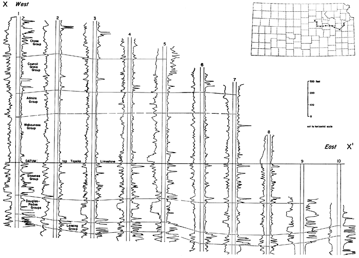
A west-east cross section indicating the group boundaries of upper Pennsylvanian and lower Permian rocks is shown in Figure 44. From this cross section it is evident that the Wabaunsee-Admire contact is indefinite. Most other contacts are readily distinguishable, especially in all of northeastern Kansas. Difficulties are encountered, however, in tracing the groups westward to the Colorado line and southward into Oklahoma. Of special interest is the random distribution of sandstone bodies in various stratigraphic positions in different wells, indicating minor local unconformities.
Figure 44--West-east electric-log cross section from Dickinson County to Douglas County showing relation of lower Permian and upper Pennsylvanian units. Recognition of Pennsylvanian-Permian contact is difficult, owing to transitional nature of sequence (from Merriam, 1959b). An Acrobat PDF version of this figure is available.
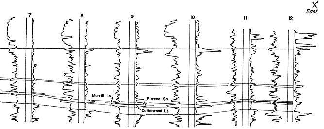
The Florena Shale occurs near the center of the Council Grove Group as the middle member of the Beattie Limestone. It is underlain by the Cottonwood Limestone Member and overlain by the Morrill Limestone Member. By virtue of its stratigraphic position, lithology, and distinctive paleontological characteristics, the exposed Florena is easily traced from Nemaha and Marshall Counties in the north to Cowley County in the south.
Detailed surface, stratigraphic, and paleontologic studies of the Florena Shale have been conducted by Imbrie (1955) and Walker (1951). Several county studies by the Kansas Survey, including those for Cowley (Bass, 1929), Riley and Geary (Jewett, 1941b), Jackson (K. L. Walters, 1953), Marshall (Walters, 1954), Chase (Moore and others, 1951a), arid Lyon (O'Connor and others, 1953), have mentioned the Florena Shale at least briefly.
Measured surface sections were compiled into composite sections, and individual rock units were traced into the subsurface by means of sequence and lithology and were correlated with the electric log of the Stanolind No. 1 Equitable Life well in Dickinson County (Fig. 43). After the electrical and radioactive characteristics of the Florena Shale and adjacent rock units had been identified, it was possible to trace these units by electric and other types of logs. Inasmuch as it was not possible to identify the Florena in cuttings from rotary samples, they were not studied.
Cross sections, based chiefly on electric and radioactivity logs and intersecting each other, were constructed so as to check stratigraphic correlations. The cross sections were so arranged that they also intersect previously published sections--including those by Collins (1947), Kansas Geological Society (1950, 1951, 1956), Lee (1953), Liberal Geological Society (1956), Lukert (1949), and Maher (1946, 1947)--as a means of checking the identification and correlation of the Florena Shale in the subsurface.
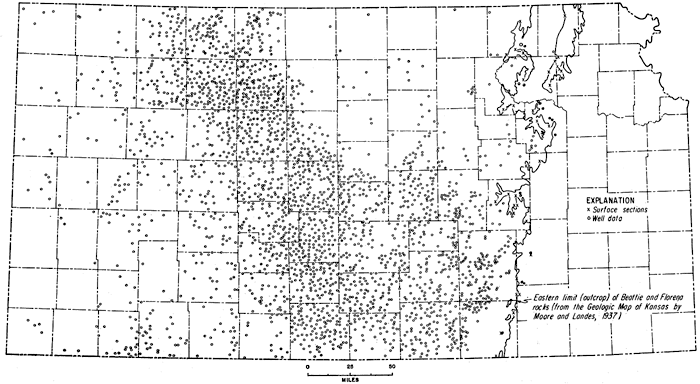
An isopachous map of the Florena Shale is presented in Figure 45 (Imbrie, Laporte, and Merriam, 1959). Configuration of the contours is based on about 2,500 surface and subsurface control points (Fig. 46). The eastern limit of control is marked by the outcrop pattern of the Cottonwood Limestone, which underlies the Florena Shale. The isopachous map was prepared at a scale of 1:1,000,000 and contoured at 2-foot intervals, although only 4-foot contours are reproduced in the figure.
Figure 45--Isopachus map of Florena Shale in Kansas, based on about 2,500 control points (Fig. 46). Contour interval 4 feet. Maximum thickness, about 18 feet, in southwestern Sedgwick County. A larger version of this figure is available.
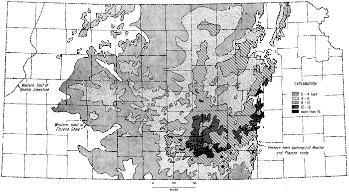
Figure 46--Map showing location of surface and subsurface control points used in constructing Florena isopachus map (Fig. 45). A larger version of this figure is available.
Along the outcrop area, Imbrie (personal communication, July 10, 1958) found the formation to range in thickness from a featheredge to 15 feet. The maximum thickness along the outcrop was found in Chase County, from which area the Florena thins both northward and southward. In Osage County, northern Oklahoma, the Florena thins to a bedding plane between the Morrill and Cottonwood Limestones. To the north, in Nemaha County, Nebraska, the unit thins to 1.3 feet thick. In the subsurface the formation was found to range in thickness from a featheredge to 18 feet, the maximum thickness occurring in southwestern Sedgwick County. In the subsurface of south-central Kansas, the Florena seemingly is absent in south-central Cowley County. The western edge of the Florena Shale in western Kansas extends in an irregular line from Norton County on the north to Clark County on the south. Several small outliers in northeastern Decatur County, western Sheridan County, and northeastern Logan County lie west of the pinchout.
In extreme northwestern Kansas, diagonally across western Rawlins County, eastern Sherman County, and Wallace and Greeley Counties, the Beattie Limestone pinches out. In the area between the Beattie Limestone pinchout and the zero line of the Florena (Fig. 45), the Morrill Limestone is in contact with Cottonwood Limestone, as shown by the stratigraphic cross section (Fig. 47). A paleogeographic sketch map prepared by Moore (1953) also shows the geographic extent of the Beattie Limestone; however, information obtained subsequent to the preparation of Moore's map reveals that the Beattie Limestone pinches out in extreme northwestern Kansas.
Figure 47--West-east electric-log cross section showing relation of Florena Shale to adjacent units, and westward pinchput of Beatie Limestone. A connected version of this figure is available.
Within the area where Florena beds are present in the subsurface of Kansas, the configuration of contours seems to reveal irregular thickness. On closer examination, however, the changes in thickness can be interpreted to reflect present and past structure.
Pennsylvanian-Permian Boundary
Because of the similarity of rock units of the Wabaunsee Group (Upper Pennsylvanian) and Admire Group (Lower Permian) in the subsurface, it is difficult to determine the boundary between the two systems. A disconformity separates the Pennsylvanian from the Permian at least locally and may be demonstrated at the surface where exposures can be examined in more detail than is possible in work with rotary well samples; however, little evidence from subsurface data supports or denies the existence of a regionally significant break at or near the Wabaunsee-Admire boundary. In places a sandstone may be present at about the stratigraphic position of the Brownville Limestone (uppermost division of the Wabaunsee Group), possibly indicating channel cutting and therefore at least a local hiatus (Pl. 15A, 15B). The regularity in thickness of the two groups (Wabaunsee and Admire) suggests that the contact generally is conformable. About the contact, Mudge has stated (1957b, p. 116):
. . . In most places remote from the outcrop, the writer could not be certain which thin beds of limestone, if any, were correlative with the uppermost limestone members of Pennsylvanian age and with the lowermost limestone members of Permian age. . . . In the lowermost Permian beds, the base of the Foraker limestone, and in places the Five Point limestone member of the Janesville shale, can be identified. . . . In the uppermost Pennsylvanian rocks, the Tarkio and Howard limestones locally are identifiable above the Topeka limestone. . . . The present writer, for example, tentatively assigns the boundary between the systems at 100 to 150 feet beneath the base of the Foraker limestone, in logs near the outcrop area. . . .
Plate 15--A, Contact of Permian (Towle Shale) and Pennsylvanian (Brownville Limestone) on U.S. Highway 40 just west of Maple Hill road, Wabaunsee County (sec. 26, T. 11 S., R. 12 E.). B, Indian Cave Sandstone (basal Permian) exposed at Echo Cliffs near Dover, Wabaunsee County (NW SW sec. 5, T. 13 S., R. 13 E.). C, Heebner Shale overlying Leavenworth Limestone (Oread Formation) in road cut on West 7th Street, Lawrence, Douglas County. D, Topographic escarpment held up by Captain Creek Limestone, just west of Altoona on Kansas Highway 47, Wilson County.
My study supports Mudge's conclusion that placement of the boundary in the subsurface is arbitrary. Lee (1956, p. 107) also had trouble placing the boundary, for he said:
The relation of the Wabaunsee group at the top of the Pennsylvanian System to the overlying Admire group at the base of the Permian System is obscure in the subsurface. The lower beds of the Admire, like the upper beds of the Wabaunsee, consist of sandy shale, sandstone, and thin interstratified limestone beds, none of which can be satisfactorily identified in the subsurface in either sample or electric logs. . . .
Branson (1960a; 1960b) has recently recommended that the Pennsylvanian-Permian boundary be moved upward to the base of the Wellington Formation. The strata now classified as Wolfcampian (Lower Permian) would then be placed in a so-called Lyonian Series (named from Lyon County, Kansas) of Late Pennsylvanian age, and the term Wolfcampian would be abandoned. There is some merit in this proposal, but at present little is to be gained by moving a boundary that reached reasonable stability only in the last two decades after being moved up and down numerous times. In the subsurface it is locally as hard to recognize the base of the Wellington as the Brownville; the easiest boundary to recognize in the subsurface is judged to be the base of the Americus Limestone (Foraker Limestone), but little purpose is served by changing the boundary a few feet in transitional beds.
Pennsylvanian Deposits
Pennsylvanian deposits in Kansas are divided into five series (in descending order): Virgilian, Missourian, Desmoinesian, Atokan, and Morrowan. [Note: Recent Kansas Survey usage of these terms has been as stages, although they have been widely regarded as series.] Because much has been written on the stratigraphy of the outcropping Pennsylvanian rocks of Kansas, little needs to be said here other than to reemphasize the cyclic nature of these beds. For the most part, the cycles consist of marine limestone and shale, alternating with nonmarine clastic deposits. At the upper contact, as already stated, Pennsylvanian rocks in Kansas are gradational with Permian rocks, and the lower contact with Mississippian rocks is unconformable. Deposits of Pennsylvanian age cover all of Kansas except the extreme southeastern corner in Cherokee County (Fig. 48).
Figure 48--Map of Kansas showing surface and subsurface distribution of Pennsylvanian deposits.
In eastern Kansas Pennsylvanian beds dip gently westward, forming cuestas with very gentle dip slopes to the west and relatively steep east faces (Pl. 15D); the area is known as the Osage Plains. Pennsylvanian rocks form a wide outcrop band which crosses the state diagonally from Doniphan and Nemaha Counties on the north to Cherokee and Chautauqua Counties on the south. East-flowing streams have scalloped the many prominent east-facing escarpments to form an irregular pattern.
The nature of Pennsylvanian deposits in Kansas has been treated in detail by Moore (1949a). His condensed description of these beds is especially apropos and is reproduced here (1949a, p. 9):
The Kansas Pennsylvanian rocks may be compared to a small stack of many-colored sheets of paper ranging in weights from thinnest onion-skin to cardboard. Each sheet of some specified color represents a certain kind of rock, such as black platy shale, light-gray calcareous shale, coal, a particular sort of limestone, and so on. The extreme relative thinness of the sheets as compared to their lateral dimensions suggests the small vertical measurements (ranging from less than 1 foot to not more than 25 feet generally) of Pennsylvanian rock units which can be traced 100 to 400 miles along the outcrop and similar distances at right angles to the outcrop underground. Of course, there are irregularities. Some layers vanish here and there, and they may show local pinching or swelling in the area where they persist. These are features which we should expect to find. The outstanding character of the Pennsylvanian rocks north of Oklahoma, nevertheless, is stratigraphic regularity and this makes possible application of the same classification and nomenclature of divisions (with very minor variations) throughout the States of Kansas, Missouri, Iowa, and Nebraska.
Actually, this succession of beds could be and has been described as monotonous. Several important features of stable-shelf-deposited sedimentary units have been pointed out, including: (1) lateral persistence of ultrathin beds, (2) tremendous ratio of width to thickness (in some layers millions of times), (3) extreme sharpness of boundaries (Pl. 15C), and (4) cyclic nature of the deposits. Any explanation of their origin must satisfy these parameters.
Although much has been written on the origin and development of cyclothems, they are little understood. Several explanations of their formation have been suggested; generally these include eustatic changes of sea level, tectonic movements, complex environmental changes, or a combination of factors.
Cyclothems may be symmetrical or asymmetrical, depending on the arrangement of the marine and nonmarine components. A nonmarine to marine to nonmarine arrangement is symmetrical and gives rise to units of a cyclic nature, whereas nonmarine to marine followed by nonmarine to marine is asymmetrical or hemicyclic. Inasmuch as the transgressive phase of the cyclothem is usually better represented (or better preserved) than the regressive part, most cyclothems exhibit asymmetrical aspects. Members of an ideal cyclothem are presented in Table 1 (Moore, 1935b). Seldom are all members of a cyclothem represented at a single locality; either they were not developed or they were developed and subsequently destroyed. Because cyclothems are bundles of genetically related rocks, they do not necessarily represent the best grouping of units for mapping; in Kansas they are not mapped.
Table 1--Members of an ideal cyclothem, designated upward (from Moore, 1935b).
| .9 | Shale (and coal). |
| .8 | Shale, typically with molluscan fauna. |
| .7 | Limestone, algal, molluscan, or with mixed molluscan and molluscoid fauna. |
| .6 | Shale, molluscoids dominant. |
| .5 | Limestone, contains fusulinids, associated commonly with molluscoids. |
| .4 | Shale, molluscoids dominant. |
| .3 | Limestone, molluscan, or with mixed molluscan and molluscoid fauna. |
| .2 | Shale, typically with molluscan fauna. |
| .1c | Coal. |
| .1b | Underclay. |
| .1a | Shale, may contain land-plant fossils. |
| .0 | Sandstone. |
The different fundamental lithologic compositions of major stratigraphic units allow different types of cyclothems, of which only two are presented here graphically (Fig. 49). Each Permian Wolfcampian cyclothem represents a single advance and retreat of the sea, i.e., nonmarine to marine to nonmarine conditions. Location of the cyclothemic boundaries follows the usage of Elias (1937a) and differs somewhat from that shown by Jewett (1933). Note in particular that the Cottonwood cyclothem (Fig. 49A) consists of parts of three formations. Following previous practice, the cyclothem is named for the limestone unit representing the culminating phase of transgression.
Figure 49--Examples of types of cyclothems and megacyclothems represented in Pennsylvanian and Permian deposits of Kansas: A, Cottonwood cyclothem (Wolfcampian); B, Wreford megacyclothem (Wolfcampian); C, Dover cyclothem (Virgillan); and D, Oread megacyclothem (Virgilian). Correction: read Pillsbury for Langdon; Dover Limestone and Dry Shale are members of Stotler Limestone (Moore and Mudge, 1956).
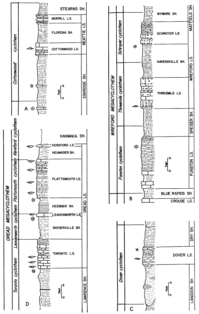
The Wabaunsee Group (Virgilian) cyclothems are well exemplified by the Dover Limestone and adjacent formations (Fig. 49C). Both transgressive and regressive units are present in the cyclothem, which includes nonmarine to marine to nonmarine deposits, making it symmetrical.
A complex bundle of related units forms what R. C. Moore has referred to as a megacyclothem. An example of a Permian megacyclothem is shown in Figure 49B. The boundaries of this megacyclothem were adjusted from those proposed by Moore and Merriam (1959) in order to coincide with individual cyclothemic boundaries as recognized previously by M. K. Elias. The name of the megacyclothem is taken from a prominent limestone formation in the unit. The type megacyclothem is perhaps represented by the Oread Limestone and adjacent units (Fig. 49D).
A megacyclothem has been considered to be a grouping of partial cyclothems or to be one complex unit. Weller (1958,1960) has proposed that a group of closely associated successive megacyclothems, supposedly as represented by those of the Shawnee Group (Virgilian), be termed a hypercyclothem.
Major stratigraphic units, genetically related and systemic in size although not necessarily corresponding to systemic boundaries, have been recognized for many years. [Note: Even larger, grand cycles were rccognized by Elias (1945).] Historically these were the first units to receive attention from early workers, at a time when little if any data were available. As more and more detailed work was done the big units were forgotten; however, in recent years more attention has been given to these units.
These major stratigraphic units, many of which are present in Kansas, have been termed megagroups in Illinois and formally named by Swann and Willman (1961). Sloss, Krumbein, and Dapples (1949) termed large assemblages sequences and considered them rock units that could be named. These large rock groupings termed megagroups or sequences represent major events in the course of earth history, and because they follow a repetitious pattern can be considered cyclic in nature. The term magnacycle, suggested by R. C. Moore, is here proposed for these large, complex, cyclic rock units.
Magnacyclothems in Kansas are shown in relation to major stratigraphic units in Figure 50. Since it is not proposed here to introduce names for these features, letter symbols are used.
Figure 50--A generalized columnar section of Kansas rocks showing relation of major units to magnacycles. At least nine magnacycles are recognizable in Paleozoic and Mesozoic rocks.
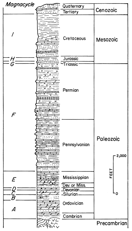
Although most magnacycles are either incompletely developed or repeated in portions, the Pennsylvanian-Permian one is the best and most complete example in Kansas. An ideal magnacyclothem, which is asymmetrical, begins with coarse clastics grading into finer ones interspersed with some carbonate units. The number of carbonate units increases and they may become cherty. Dolomite, gypsum, anhydrite, and other evaporitic deposits, along with redbeds, become abundant in the section; salt is present. The redbed and evaporitic sequence completes the magnacycle and another starts anew with the clastics. Many cyclothems and megacyclothems are discernible in the magnacyclothem, but the character of the cycles changes as the magnacyclothem develops in response to outside influence. Although this sequence is, of course, highly generalized and many exceptions can be found, the concept is usable and valuable in understanding stable, shelflike, rhythmic deposits such as are found in Kansas.
Because numerous units are recognized in the Pennsylvanian System of Kansas, only groups and a few key units will be mentioned here. For a detailed description of the units the reader is referred to Moore (1949a).
Pennsylvanian studies in Kansas began as early as 1859, when Meek and Hayden, two of the early Federal Survey geologists, studied the Kansas River section (Moore, 1949a). Other early studies include those of Mudge (1866), Swallow and Hawn (1865), and Swallow (1866). Studies in adjacent states were made by Broadhead (1866) in Missouri, White (1870) in Iowa, and Meek (1872) in eastern Nebraska. Later, work was carried on by Haworth (1894, 1895), Haworth and Kirk (1894), Adams, Girty, and White (1903), Beede and Rogers (1908), and many others. Beginning in the late 1920s, numerous important papers on the Kansas Pennsylvanian were published by M. K. Elias, J. M. Jewett, N. D. Newell, and W. H. Schoewe, and especially by R. C. Moore. In addition to Kansas studies, considerable work was undertaken in neighboring states (Moore, 1949a).
The Wabaunsee Group (Virgilian Series) conformably overlies the Shawnee Group and is made up principally of shale, but it contains thin interbedded limestone and local sandstone lenses. None of the shales in the subsurface have any particularly outstanding characteristics that make them readily identifiable (Merriam, 1959b). Likewise, the limestones, most of which represent a culminating phase of the cyclothem to which they belong, are indistinguishable in well samples (Fig. 49A). Most Wabaunsee limestones are light gray to brownish, slightly crystalline, and fusulinid bearing. Identification of units is based mainly on their thickness and sequence, although under some conditions the Dover (Pl. 16A), Zeandale (Pl. 16B, 16C), and Howard (Pl. 16D) Limestones can be recognized by their lithology. Channel-sandstone bodies can and do occur at almost any stratigraphic position in the group (Mudge, 1956), confusing the normal sequence and correlations. The top of the Wabaunsee Group is marked by the Brownville Limestone (Pl. 15A), which is the topmost unit of the Pennsylvanian as now recognized; regrettably, this unit is not easily recognized in the subsurface.
Plate 16--A, Pillsbury Shale overlain by Dover Limestone in road cut on Kansas Turnpike, Lyon County (SE SE NW sec. 18, T. 16 S., R. 13 E). B, Closeup of Tarkio Limestone showing many fusulinids. C, Tarkio Limestone overlain by Wamego Shale approximately 8 miles west of Topeka, Shawnee County (sec. 29, T. 11 S., R. 14 E.). D, Howard Limestone (note Nodaway coal in Aarde Shale Member beneath Church Limestone Member) on Kansas Turnpike just east of South Topeka Interchange, Shawnee County.
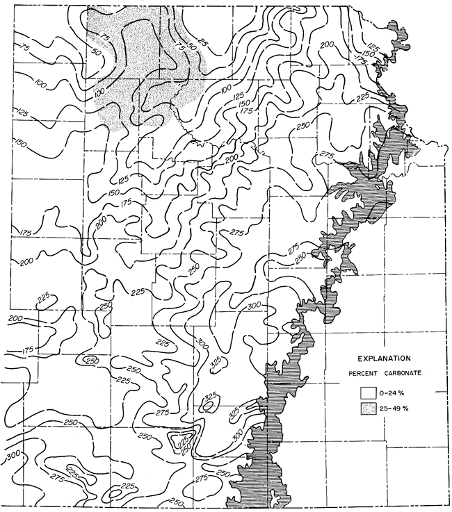
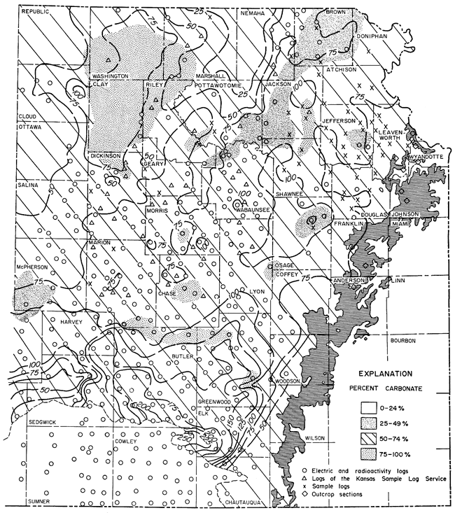
Thickness of the Wabaunsee Group (Fig. 51) ranges from about 320 to 520 feet. The northern part of the Nemaha Anticline appears as an area of thinning, but farther south this relation of thickness to structure is poorly shown. On the other hand, the Abilene Anticline is reflected prominently by thinning of the group over its crest. Wabaunsee deposits thicken in the Salina Basin and east of the Nemaha Anticline. The carbonate ratios of the Wabaunsee Group are low, ranging from about 5 to 29 percent. The area of the Salina Basin has the highest ratio.
Figure 51--Isopachous and percentage-carbonate map of the Wabaunsee Group in eastern Kansas. Horizontal ruling indicates area of outcrop. Control density shown on Figure 58. Contour interval 25 feet.
In northwestern Kansas, Hockens (1959) found that the group consists mainly of shale containing thin but persistent limestone beds. Sandstone lenses are present throughout the sequence, but they can be traced only short distances. The shale units thin and many pinch out on the Central Kansas Uplift (Fig. 52). Hockens determined that all units below the Auburn Shale in the Wabaunsee Group seemingly are absent in northwestern Kansas. The group comprises white to gray, thin-bedded, dense, locally fusulinid-bearing limestone interbedded with gray to red, calcareous, sandy shale (Hockens, 1959, p. 15).
Figure 52--West-east electric-log cross section of Pennsylvanian and lower Permian rocks from Sherman County to Stanolind No. 1 Equitable Life well in Dickinson County. An Acrobat PDF version of this figure is available.
The Shawnee Group (Virgilian Series) contains seven formations: four bundles of limestone separated by three shales. A limestone bundle plus parts of the overlying and underlying shale formations constitutes a megacyclothem, as defined by Moore (1935b). Within each megacyclothem are several members with characteristic lithologies, for example, radioactive black shale, which are identified easily both in well samples and on electric and radioactivity logs.
Of the black shale members, the Heebner is the most important, because it can be recognized with the least difficulty over the largest area (Pl. 15C). Indeed, it is used as a datum for much stratigraphic and structural work in the subsurface of central and western Kansas (Fig. 53; Merriam and Jewett, 1956). Other shale units are more difficult to recognize in the subsurface because they lack identifying characteristics and because they tend to be mixed with other samples by caving in rotary holes. As on the surface, however, other lithologies of the megacyclothem can be recognized--for instance, red shale and coal, which underlie some of the limestone bundles; dense, fusulinid-bearing limestone subjacent to the black shale; and very fossiliferous, locally cherty limestone overlying the black shale. Of the last-mentioned limestone type, the Ervine Creek Member of the Deer Creek Limestone (Pl. 17B) and the Plattsmouth Member of the Oread Limestone (Pl. 17D) are easier to recognize on well logs than the Beil Member of the Lecompton Limestone (Pl. 17C). The Topeka Limestone (Pl. 17A), uppermost formation of the Shawnee Group, also is readily identified because of the preponderance of shale in the overlying Wabaunsee Group, which is in sharp contrast to the limestone-dominated Shawnee Group. The top of the Topeka in the subsurface, however, probably is not precisely equivalent to the stratigraphic top of the formation as defined on the surface, because the upper part of the unit seems to be absent in the subsurface.
Figure 53--West-east electric-log cross section showing stratigraphic relation of Oread Limestone (Shawnee Group) and Douglas-Pedee Groups. Note persistent and easily recognized black Heebner Shale Member. A larger version of this figure is available.
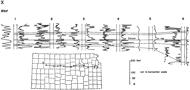
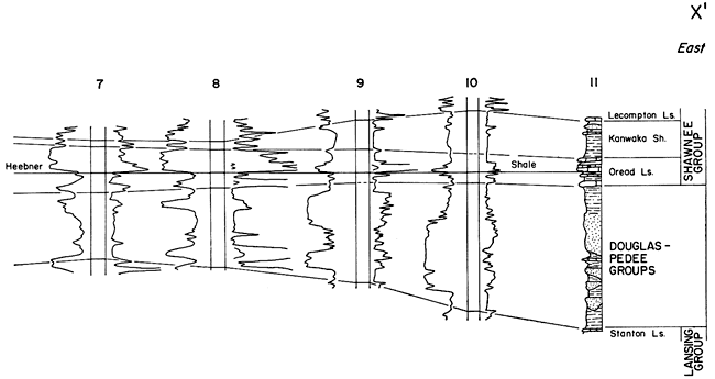
Plate 17--A, Topeka Limestone exposed on Kansas Turnpike at Topeka Service Area, Shawnee County. B, Deer Creek Limestone, underlain by Tecumseh Shale, on Kansas Turnpike about 8 miles west of West Lawrence Interchange, Douglas County (sec. 22, T. 12 S., R. 18 E.). C, Lecompton Limestone in road cut on Kansas Turnpike 6 miles west of West Lawrence Interchange, Douglas County (sec. 24, T. 12 S., R. 18 E.). D, Oread Limestone (lowest formation of Shawnee Group) about 3 miles west of West Lawrence Interchange, Douglas County (NW sec. 21, T. 12 S., R. 19 E.). Members recognized include (ascending): Toronto Limestone, Snyderville Shale, Leavenworth Limestone, Heebner Shale, and Plattsmouth Limestone.
The Lecompton Limestone is a good example of overall increase in thickness because shale units thicken southward (Fig. 54). The formation increases from 40 feet in northwestern Douglas County to about 95 feet in northwestern Woodson County, a distance of approximately 40 miles, whereas the ratio of limestone to total section decreases from 1:2 to 1:6. The ratio decreases more in Oklahoma, where only some of the limestone members may be recognized, and the amount of clastic material increases. Special notice should be made of the increase in prominence southward of the Avoca Limestone and decrease in prominence of the Spring Branch Member. This also occurs in other units, notably in the Beattie Limestone, where in the northern part of the state the Cottonwood Limestone Member is the bench former and southward the Morrill Limestone Member is the scarp former. Such a reversal in prominence has resulted in many a miscorrelation by those placing too much emphasis on topographic expression.
Figure 54--Southwest-northeast cross section of outcropping units of Lecompton Limestone (Shawnee Group) in east-central Kansas. Note general southward thickening of clastic section. A larger version of this figure is available.
The thickness pattern of the Shawnee Group (Fig. 55) is similar in many ways to that of the Douglas-Pedee. Thickness of the Shawnee ranges from about 200 to 510 feet. Thin areas overlie the crests of the Nemaha and Abilene Anticlines. East from the Nemaha, the deposits thicken into a trough which extends irregularly northeastward from Chase County through Lyon, Wabaunsee, Shawnee, Jackson, and Brown Counties to Doniphan County. The axis of this trough is west of the one discernible on the Douglas-Pedee map. East of the basinal trough, which probably represents the axis of the Forest City Basin in Shawnee time, the group thins toward the outcrop area. A low carbonate ratio in two areas just east of the Nemaha Anticline suggests some relationship to that feature. The highest carbonate ratio is in the Salina Basin and in two small areas on and adjacent to the Nemaha in Pottawatomie and Atchison Counties.
Figure 55--Southwest-northeast cross section of outcropping units of Lecompton Limestone (Shawnee Group) in east-central Kansas. Note general southward thickening of clastic section.
The Shawnee Group in northwestern Kansas is easily recognized but thins westward from Dickinson County (Hockens, 1959). Some of the shales between the limestone bundles thin so much that they are thinner than the shale units within the limestone formations. This makes identification based on sequence and thickness all but impossible.
[Note: Recent work by S. M. Ball (personal communication, December 10, 1962) indicates the desirability of dropping the term Pedee and including the units in the Douglas Group.]
The Douglas (Virgilian) and Pedee (Missourian) Groups are composed almost entirely of shale but contain a few thin limestone beds, local sandstone channel fillings (Pl. 18A, 18B, 18C), and coal beds. Lacking any distinguishing gross lithologic characteristics, the groups can be differentiated only with great difficulty, and it is not possible to recognize any of their subdivisions in the subsurface (Fig. 56). Thus, they will be considered together because the unconformity between the Missourian and Virgilian Series at the base of the Douglas Group is obscure. As a matter of fact, it is difficult to ascertain the contact at many places on the surface where the beds are well exposed.
Plate 18--A, Ireland Sandstone channel filling exposed in cross section on Kansas Highway 96 approximately 3 miles west of junction with Kansas Highway 39, Wilson County (SE sec. 8, T. 28 S., R. 14 E.). B, Ireland Sandstone at Hole-in-the-rock near Baldwin Junction just west of intersection of U.S. Highways 59 and 56, Douglas County (NW sec. 2, T. 15 S., R. 19 E.); photo by W. R. Atkinson. C, Cross-bedded Tonganoxie Sandstone exposed on Kansas Turnpike at Mile 16.
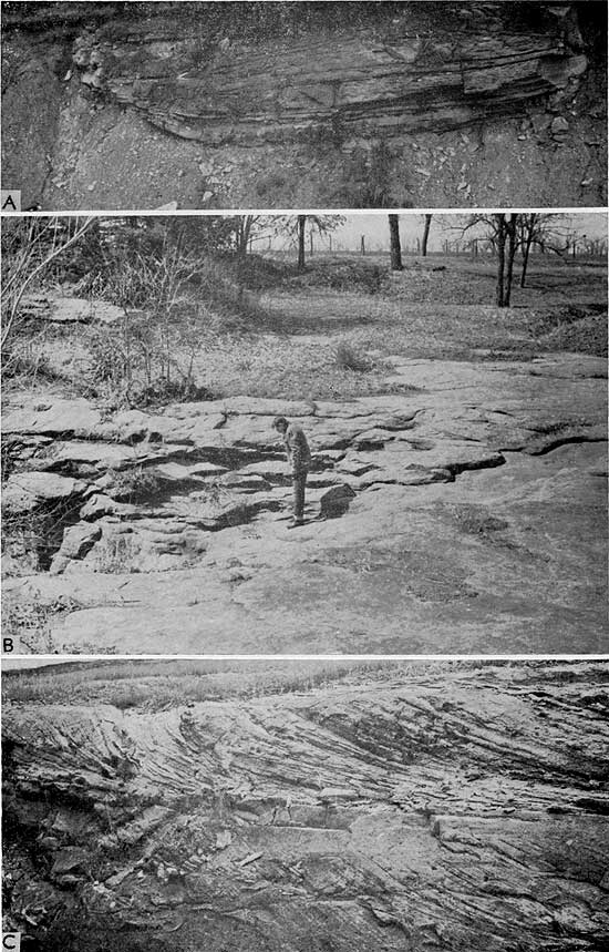
Figure 56--Subsurface cross section of Pennsylvanian rocks along Kansas Turnpike in east-central Kansas (from Merriam and Jewett, 1956). Note varied nature of Douglas-Pedee Groups and seeming lack of persistent beds.
The Douglas-Pedee thickness map (Fig. 57) shows little agreement between structural provinces and thickness, especially along the Nemaha Anticline. Thickness of the combined groups ranges from about 20 to 350 feet. The thinnest Douglas-Pedee is in northeastern Marshall County and northwestern Nemaha County along the northern part of the Nemaha and Abilene Anticlines. The Nemaha is not reflected farther south, indicating possible quiescence of this structure at the time of Douglas-Pedee deposition; however, the Abilene structure is fairly obvious. One area of great thickness occurs in the Forest City Basin, extending in an irregular belt northeastward through Lyon, Osage, and Douglas Counties. This thick section was probably the basinal trough in Douglas-Pedee time. The highest carbonate ratios occur in the area of the Salina Basin. In many areas no carbonate rocks are present in the Douglas-Pedee sequence; the range of carbonate percent is from 0 to about 50.
Figure 57--Isopachus and percentage-carbonate map of the Douglas-Pedee Groups in eastern Kansas. Horizontal ruling indicates area of outcrop. Control density shown on Figure 58. Contour interval 25 feet.
Sanders (1959) mapped the respective net thicknesses of sandstone above and below the Haskell Limestone in northeastern Kansas. Above the Haskell is the Ireland Sandstone and below it is the Tonganoxie; contour lines on both maps (Sanders, 1959, pl. 1 and 2) reveal a sinuous pattern, which suggests drainage channels. Thicknesses range from 0 to 100 feet for sandstones above the Haskell and from 0 to 160 below it.
The Douglas-Pedee in northwestern Kansas consists of gray-green calcareous shale and ranges in thickness from a featheredge to 13 feet (Hockens, 1959). Locally, the groups are absent on uplifts. The Toronto Limestone of the Oread Formation also pinches out in the northern part of Cheyenne, Rawlins, and Decatur Counties, so that it is impossible to distinguish shale of the Douglas from the Snyderville Shale, the next member above the Toronto in the Oread Limestone. Preliminary investigations indicate that in northwestern Kansas the areal extent of the Pedee is very small (Hockens, 1959).
The Lansing Group (Missourian Series) consists mainly of alternating beds of limestone and shale, which have been grouped together in three formations. Units of this group can be recognized, although in places with difficulty, westward into Colorado (Parkhurst, 1959a). Lithologically, the most distinctive division in the subsurface of this group is the Eudora Shale. In many places the Eudora is a dark-gray to black, radioactive shale, easily recognized on gamma-ray logs, as well as in well samples. The Lansing is conformable with the underlying Kansas City Group, but the upper contact is unconformable; locally the upper part of the Lansing has been removed by erosion. Although the South Bend Limestone is defined as the topmost unit of the Lansing Group, the member is not everywhere present because it has been removed by erosion or was never deposited. Where the South Bend is absent, the underlying Rock Lake Shale and overlying Weston Shale can not be differentiated; thus the Stoner Limestone is used to mark the top of the Lansing.
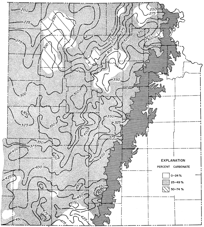
Thickness of the Lansing Group in the subsurface of eastern Kansas ranges from about 20 to 250 feet (Fig. 58). The thin areas generally overlie the crests of the Nemaha and Abilene Anticlines, whereas thicker deposits occupy the Forest City and Salina Basins. Because most of the irregularities of the pre-Pennsylvanian surface were concealed by burial under Desmoinesian and lower Missourian deposits, this thickening and thinning can be explained by structural movements. The carbonate ratio of the Lansing Group ranges from about 20 to 90 percent but has no readily apparent correlation with thickness. The highest percentages of carbonate are found in the Salina Basin and in irregular patches along the crest of the Nemaha Anticline and in the Forest City Basin. Carbonate ratios are low just east of the Nemaha in the vicinity of the Brownville Syncline and in southern Chautauqua County near the Oklahoma line. The irregular high carbonate ratios may indicate marine limestone buildups similar to those at the surface in Wilson and Montgomery Counties.
Figure 58--Isopachus and percentage-carbonate map of the Lansing Group in eastern Kansas. Horizontal ruling indicates area of outcrop. Contour interval 25 feet.
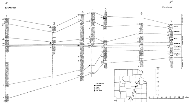
The area of limestone buildups in southeastern Kansas in the Lansing Group has attracted considerable attention, and rightly so, because farther west in the subsurface, limestone buildups may control oil accumulation. Many have pointed out various aspects of this increased thickening, including Newell (1933), Wagner and Harris (1953), Wilson (1957), Davis (1959), Harbaugh (1959, 1960), and Kansas Geological Society (1962). A generalized cross section along the outcrop in eastern Kansas is shown in Figure 59. It may be seen from this cross section that aU limestone members of the group, except the Merriam, increase in thickness southward.
Figure 59--Southwest-northeast cross section of outcropping units of Lansing Group in eastern Kansas (compiled from surface sections measured by Kansas Survey staff, especially R.C. Moore and N.D. Newell). Note southward thickening of carbonate units.
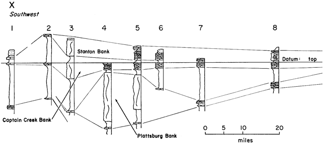
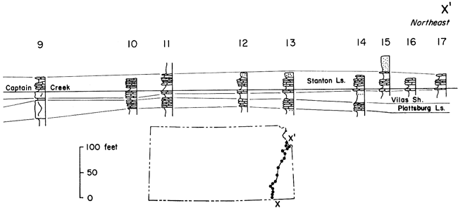
Areal distribution of the thick marine bank in the Plattsburg Limestone in the Neodesha-Fredonia area is shown in Figure 60. Harbaugh (1959, p. 291) came to the following conclusions regarding this anomaly:
The Plattsburg Limestone is anomalously thick in the Neodesha-Fredonia area, increasing from an average of about 20 feet to a maximum thickness of 115 feet. Thickening is due to increase in the Hickory Creek Shale (middle member) from 1 to 45 feet, and the Spring Hill Limestone (upper member) from 3 to 88 feet in thickness. . . .
The principal cause of thickening of the Plattsburg Limestone is interpreted to be deposition of an extensive, lens-shaped marine bank that rose above the general level of the surrounding sea floor. The bank was at least 14 miles long in a northwest-southeast direction, and about 10 miles wide. Two smaller, detached thickened portions of the Plattsburg Limestone in the area probably represent small banks. A second cause of thickness variations in the Plattsburg Limestone is local structural warping during deposition, which permitted greater thicknesses to accumulate over downwarps and lesser thicknesses over upwarps.
Thickness of the Vilas Shale also has been affected by this cause. Thickness of the Vilas Shale has been observed to be inversely related to thickness of the Plattsburg Limestone at most localities. Part of the Vilas Shale is interpreted to be an off-bank time equivalent of part of the thickened Spring Hill Member.
Deposition of the bank is interpreted to have been strongly influenced by lime-secreting organisms, including crinoids, bryozoans, brachiopods, mollusks, and algae. The organisms may have influenced deposition of silt and clay (Hickory Creek Member) by exerting a sediment-binding effect, and probably helped stabilize slopes at least as great as 70 on the edges of the bank. In addition, they contributed large quantities of calcareous material to the upper part (Spring Hill Member) of the bank.
Where thick, the Spring Hill Member of the Plattsburg is divided into three tabular lithologic subdivisions in regular vertical sequence. The lower subdivision contains abundant irregular fragments and pellets, much of it seemingly of algal origin. The middle subdivision contains abundant visibly crystalline calcite intimately associated with encrusting calcareous algae. The upper subdivision contains abundant calcarenite composed of grains of various degrees of rounding and sorting. During deposition of the crystalline subdivision, lime-secreting algae may have imparted rigidity to deposits forming on the bank, thus creating a reef if the bank extended into shallow water. During deposition of other parts of the Plattsburg bank, the deposits probably were not wave resistant.
Porosity in the Spring Hill Member is related to limestone lithology. The crystalline limestone subdivision, where pores and vugs are conspicuous in visibly crystalline calcite, is most porous. The thickened Spring Hill Limestone of the Neodesha-Fredonia area may provide an example of a porous limestone lens that might serve as an oil reservoir; some oil pools in Pennsylvanian limestones of central and western Kansas may occur in porous lenses of similar origin.
Figure 60--Isopachus maps of rock units in Neodesha-Fredonia area: A, Plattsburg Limestone; B, Vilas Shale (adapted from Harbaugh, 1959).
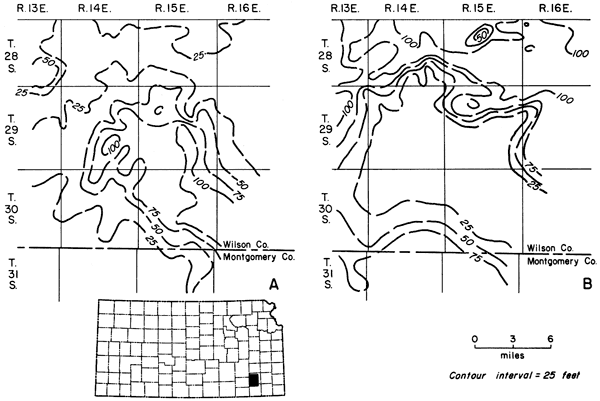
The Plattsburg Limestone is about 20 feet thick in the northeastern and east-central part of the state (Pl. 19A) and thickens in southeastern Kansas to a maximum of about 115 feet (Pl. 19B, 19C). Small marine banks in the Plattsburg, such as the one near Garnett in Anderson County (Pl. 20A), also are known along the outcrop belt.
Plate 19--A, Plattsburg Limestone on Kansas Turnpike at Mile 14, Wyandotte County. B, Plattsburg Limestone forming marine bank, exposed in road cut on Kansas Highway 96 west of intersection with U.S. Highway 75 and just southwest of Neodesha, Wilson County. C, Large-scale cross beds in Hickory Creek Shale, underlain by Merriam Limestone and Lane-Bonner Springs Shale, exposed in abandoned shale pit at Brickton, Montgomery County (SW sec. 7, T. 31 S., R. 16 E.).
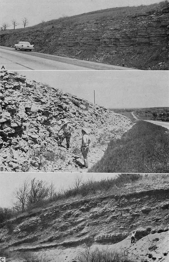
Limestone units in the Stanton Formation also thicken southward. Marine banks are known in the Captain Creek, Stoner, and South Bend Limestones. Thickness of the Captain Creek increases southward from about 10 feet (Pl. 20A) to about 45 feet (Pl. 20B). Upper Lansing limestone in southern Montgomery County near Tyro (Pl. 2OC) is composed of a cross-bedded oolite believed to have been deposited in shallow lagoons or over shallow shoals (Harbaugh, 1960).
Plate 20--A, Spring Hill Limestone, Vilas Shale, and Captain Creek Limestone (ascending) in abandoned quarry about 2 1/2 miles north of Garnett, Anderson County (sec. 12, T. 20 S., R. 19 E.). B, Captain Creek Limestone exposed in quarry on Table Mound, just west of Lehunt, Montgomery County (SE SE sec. 9, T. 32 S., R. 15 E.). C, Upper Lansing rocks exposed in abandoned quarry near Tyro, Montgomery County (sec. 30, T. 34 S., R. 15 E.).
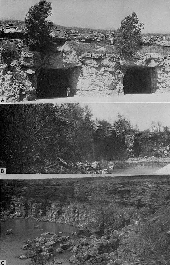
A cross section (Fig. 61) prepared to show stratigraphic relations of Lansing beds also shows an anomalous thick Lansing section in south-central Butler County. In addition, the relation of the "Stalnaker" and "Layton" sandstones to the limestones of the Lansing and Kansas City Groups is depicted.
Figure 61--Electrig-log cross section showing relation of Lansing rocks to adjacent units. Stratigraphic position of "Stalnaker" and "Layton" sandstones also in showm. Of special interest is abnormally thick carbonate section, which may represent a marine bank, in well 4 in south-central Butler County. A larger version of this figure is available.
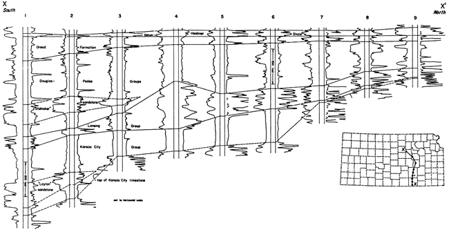
Many of the anomalously thickened limestones are known in Kansas; some seemingly are "buildups" or are in addition to the regular lithology, whereas others consist of a thickening of individual units within the "normal" sequence, and some "stray" limestones occur within predominantly shaly formations (Merriam, 1962a). These abnormalities are not by any means limited to the Pennsylvanian but are known also in Lower Permian rocks. Some units known to include thick or "extra" limestone are: Havensville Shale, Threemile Limestone, Cottonwood Limestone, Neva Limestone, Bennett Shale, and Hughes Creek Shale, all of Permian age; Soldier Creek Shale, Avoca Limestone, Toronto Limestone, Stoner Limestone, Captain Creek Limestone, Spring Hill Limestone, Iola Limestone, Drum Limestone, Winterset Limestone, Bethany Falls Limestone, and Pawnee Limestone, all of late Pennsylvanian age. Some of these and other units are known to "pinch and swell" in the subsurface farther west and this may be important in the entrapment of petroleum.
Winchell (1957) and Schulte (1959) showed their interpretation of relations of the subsurface units called "Stalnaker" and "Layton" to surface formations. The "Stalnaker" is equivalent to the Tonganoxie Sandstone and the "Layton" to the Cottage Grove and Noxie Sandstones. Winchell found that "the lithologic difference between the 'Stalnaker' and the Lansing is not the result of contemporaneous deposition of different facies but is the result of erosion of the Lansing and deposition of the Tonganoxie ('Stalnaker') sandstone in the erosional depressions and basins left after post-Missourian erosion." Schulte concluded that "the sheetlike distribution and uniform sorting of the sandstones are evidence of marine origin. . . . The Noxie Sandstone was deposited on an eroded surface as there is evidence for a disconformity both at the surface and in the subsurface." [Note: Certain lines of evidence, however, point to a facies change from units of limestone in the north to units composed mainly of sandstone in the south. If one subscribes to these data, then the "Stalnaker" and Tonganoxie are not equivalent, but the "Stalnaker" is a southern facies of Lansing beds farther north. This relationship could also be true of the sandstone units in the Kansas City Group. The relationships are still open to interpretation and further work needs to be done on the problem.] The distribution of these sandstones in south-central Kansas is shown in Figure 62.
Figure 62--Distribution of sandstone units in subsurface of south-central Kansas. A, "Cottage Grove" and "Noxie" sandstones (Schulte, 1959); B, "Stalnaker" sandstone (Winchell, 1957).
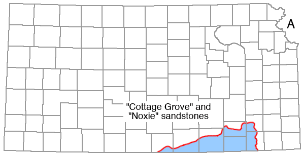
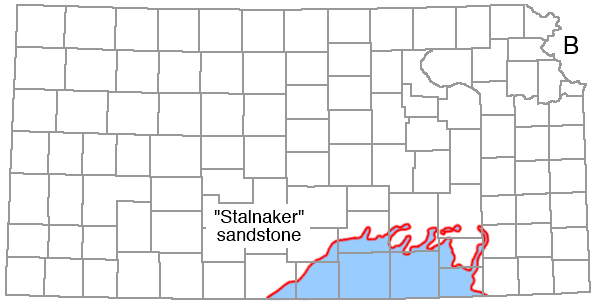
The Kansas City Group (Missourian Series) conformably underlies the Lansing and conformably overlies the Pleasanton Group. The group contains 12 formations and 27 named members of alternating marine and nonmarine units and has a thickness of about 350 feet on the outcrop. Many of the limestones are cross bedded, oolitic, and algal and locally thicken to form marine banks similar to those in the Lansing Group. Parkhurst (1959b) correlated surface units with the subsurface (Fig. 63) in conjunction with a study of Pennsylvanian units in northwestern Kansas.
Figure 63--Relation between Morgan's (1952) alphabetical designations and equivalent surface terminology, as determined by Parkhurst (1959a).
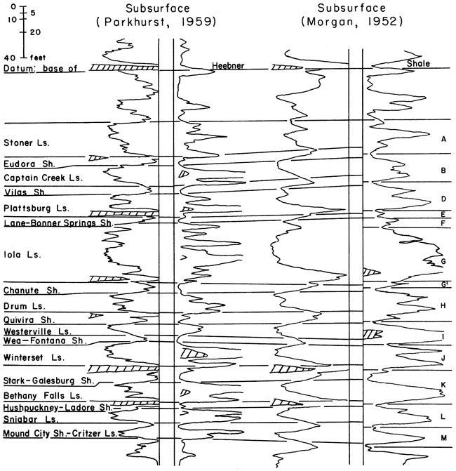
The Bonner Springs Shale, Wyandotte Limestone, and Lane Shale are conveniently referred to the upper of three subgroups. Where the Wyandotte pinches out, the Bonner Springs comes in contact with the Lane and the undifferentiated unit is termed the Lane-Bonner Springs Shale. Parkhurst found the pinchout of the Wyandotte Limestone to occur between Range 17 and 21 East in the southern part of the Forest City Basin in northeastern Kansas. In Franklin County, the Wyandotte pinches out in the subsurface along a north-south line about in the middle of the county. The maximum thickness of the unit is approximately 45 feet (S. M. Ball, personal communication, June 14, 1962). Parkhurst found that the Lane-Bonner Springs thins markedly westward but that west of the Nemaha Anticline it is nearly uniform in thickness.
Below the Lane Shale are (in descending order): Iola Limestone, Chanute Shale, Drum Limestone, and Cherryvale Shale, which have been placed together in a subgroup. The Iola Limestone is composed of three members; the middle unit, Muncie Creek Shale, west of the Nemaha Anticline exhibits strong radioactivity indicative of black shale. The upper limestone unit is persistent, but its upper boundary is difficult to determine. According to Parkhurst (1959b, p. 98):
The Raytown Limestone is a persistent unit in the subsurface; however, there is difficulty in establishing its upper boundary. . . westward. . . . This limestone increases in thickness westward and contains much interbedded shale. Many eastern Kansas exposures of the Iola formation contain a "super" limestone that overlies the massive Raytown Limestone, but no correlation is implied herein. The limestone and shale above the Raytown probably represent a build up of strata belonging to the Iola formation, but could represent a facies change of the Lane-Bonner Springs Shale or could represent beds of the Wyandotte formation.
The Iola Limestone also builds up on the surface, and where thick it is quarried extensively (Pl. 21A, 21B). The buildup is similar to those in the Lansing Group and represents a marine bank mainly algal in origin.
Plate 21--A, Iola Limestone in abindoned quarry near Carlyle, Allen County (NE SE sec. 5, T. 24 S., R. 19 E.). B, Closeup of algal Iola Limestone in Carlyle quarry. C, Winterset Limestone on east side of Canville Creek on Kansas Highway 39, Neosho County (NE sec. 23, T. 27 S., R. 20 E.). D, Lower part of Fort Scott Limestone and upper part of Cherokee Group in railroad cut in Fort Scott, Bourbon County.
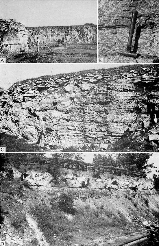
The lowest of the three subgroups of the Kansas City consists of the following formations (in descending order): Dennis Limestone, Galesburg Shale, Swope Limestone, Ladore Shale, and Hertha Limestone. The presence of several persistent radioactive black shales makes this sequence of rocks easy to identify in the subsurface. Of the upper unit, the Dennis Limestone, Parkhurst said (1959b, p. 98):
The Dennis Limestone comprises three members, the Winterset Limestone at the top, Stark Shale, and Canville Limestone at the base. The Winterset Limestone is persistent along the line of cross section and is easily recognized by its stratigraphic position above the Stark Shale. From the outcrop to the east flank of the Central Kansas Uplift the Winterset maintains a fairly uniform thickness. In general, the unit thins over the Central Kansas Uplift, and there are pronounced local variations in thickness.
The Stark Shale is recognized by its strong radioactivity and by its position in the stratigraphic sequence. It is a persistent unit along the line of cross section. The unit next below the Stark Shale, the Canville Limestone, is not present in the surface composite section and is not recognized on the cross section, therefore, the interval is referred to as the Galesburg-Stark Shale.
The Winterset Limestone has one of the more spectacular marine banks, consisting of algal limestone and cross-bedded oolitic limestone (Pl. 21C), which has its maximum development in Allen and Neosho Counties. The Hushpuckney in the Swope Limestone is a persistent and readily traceable unit because it is a radioactive black shale. Where the Middle Creek Limestone is absent, the underlying Ladore Shale can not be distinguished from the Hushpuckney and they are considered as one unit. Parkhurst (1959b, p. 100) observed the following in regard to the lowest unit of the Kansas City Group:
The Hertha Limestone consists of three members. In descending order these are the Sniabar Limestone, Mound City Shale, and Critzer Limestone. In the composite measured section only the Sniabar Limestone is present. . . . In the Forest City Basin there is little difficulty in establishing the base of the Kansas City Group. There, a predominantly shale section underlies and contrasts sharply with the limestone of the Bronson Subgroup. The recognition of the base of the Kansas City Group in the Salina Basin, however, is more difficult. Here, the limestone unit identified as the Sniabar member of the Hertha formation is underlain by limestone and shale that probably represent the lower two members of the Hertha.
Walton (1960) found that in northwestern Kansas several units of the Kansas City Group pinch out, including the Westerville Limestone and upper limestone units of the Raytown Limestone. He also concluded that the location of the source area was probably a dominant factor in distribution of the sediments of the Kansas City Group, more so than local structure. Overall, the carbonate percentage increases westward and southwestward into Colorado.
Rocks beneath the Kansas City Group and overlying the Marmaton Group are placed in the Pleasanton Group (Missourian Series). The Pleasanton is mainly composed of clastic material, mostly shale but also sandstone, limestone, and coal. Along the outcrop, the group ranges in thickness from about 70 to 130 feet. In the subsurface, recognition of these beds is by position only; thus, their recognition is dependent on tracing the base of the Kansas City and top of the Marmaton.
In northwestern Kansas, Walton (1960) found that the thickness of the group ranges from about 4 to 38 feet (Fig. 64). The northwestward thinning is mainly the result of the pinchout of a gray, fine-grained, micaceous, shaly, calcareous sandstone.
Figure 64--Isopachous map of Pleasanton Group in northwestern Kansas and adjacent areas (from Walton, 1960).
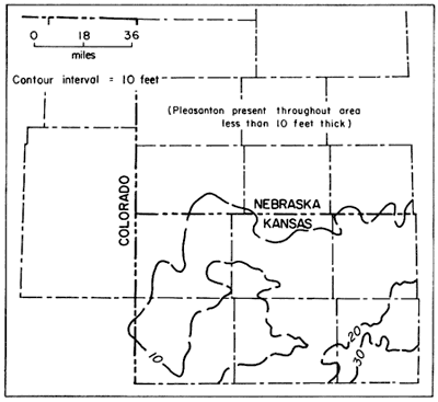
The Marmaton Group (Desmoinesian Series) disconformably underlies the Pleasanton Group. It consists of four bundles of limestone units separated by four shale formations. The formations are (in descending order): Memorial Shale (Holdenville Shale), Lenapah Limestone, Nowata Shale, Altamont Limestone, Bandera Shale, Pawnee Limestone, Labette Shale, and Fort Scott Limestone (Jewett, 1941a). On the outcrop the group is approximately 250 feet thick. Several of the limestone units support prominent scarps that can be traced for many miles.
Distribution of beds of this age, together with the underlying Atokan beds, is shown in Figure 65. Desmoinesian beds crop out in southeastern Kansas but Atokan beds are present only in the deeper parts of some basinal areas, although their exact distribution is not well known. Desmoinesian-Atokan beds are absent on the higher parts of the Nemaha Anticline and Central Kansas Uplift-Cambridge Arch (McMurray, 1962). Upper Pennsylvanian beds of Missourian and Virgilian age, however, are present on these structures, and locally beds as young as Missourian rest on rocks as old as Precambrian.
Figure 65--Subsurface distribution of lower Pennsylvanian rocks in Kansas. A, Morrowan (McManus, 1959); B, Desmoinesian and Atokan (in part from Lee, 1956).
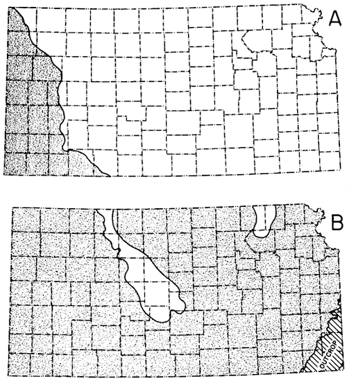
Because the Marmaton beds generally form a bundle of prominent "kicks" (limestone beds) as shown on electric logs, they may be traced over much of Kansas with relative ease (Fig. 66). Lemmons (1946) made a subsurface study of the Marmaton in southeastern Kansas. In southwestern Kansas, however, as with many other units, the Marmaton is much more difficult to differentiate with any degree of accuracy. The Fort Scott is widespread and easily recognized and thus is used as a datum for structural and stratigraphic work.
Figure 66--Correlation of units between composite surface section in east-central and southeastern Kansas and Woods No. 1 Oberle well (in SW SW NW sec. 14, T. 14 S., R. 15 E.) in Osage County.
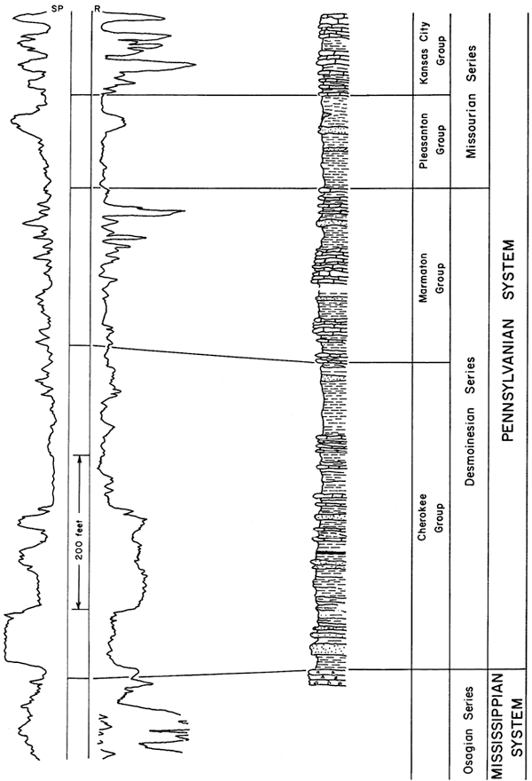
The Fort Scott Limestone includes three members: two limestone beds separated by a shale. The upper limestone is referred to as Higginsville Limestone, the separating shale as the Little Osage Shale, and the lower limestone as Blackjack Creek Limestone (Fig. 67; Pl. 21D). An isopachous map of the Fort Scott in a ten-county area in southeastern Kansas reveals that the formation ranges in thickness from 13 to 145 feet (Fig. 68). The configuration of the contours suggests that the thickening is somewhat erratic and possibly could be due to marine bank development. A study of the thickness of the Fort Scott along the outcrop reveals that the increase in thickness seemingly is due chiefly to the great abundance of Chaetetes (see Moore, 1949b).
Figure 67--Cross section of outcropping Fort Scott Limestone in southeastern Kansas showing relation of three members to each other and to underlying Cherokee beds.
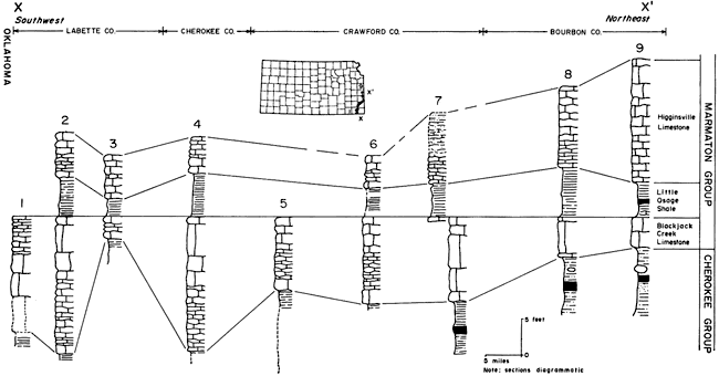
Figure 68--Isopachus map of Fort Scott Limestone in southeastern Kansas. A-A' and B-B' are lines of sections in Figure 69 (from Ashley and Merriam, 1961). An Acrobat PDF version of this figure is available.
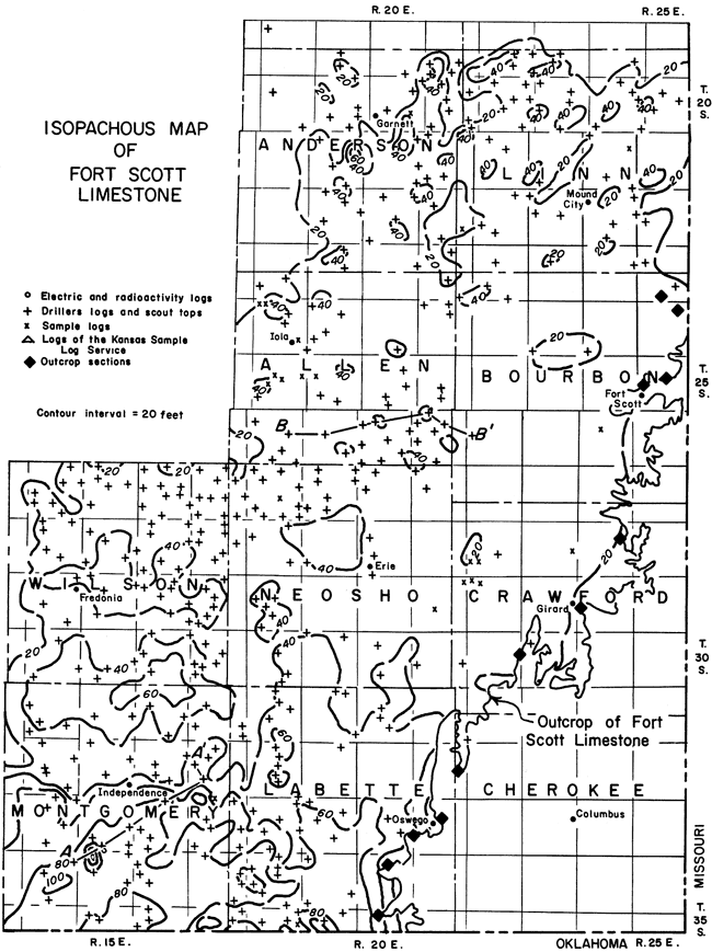
Stratigraphic relations of the units of the Marmaton are shown in Figure 69.
Figure 69--Cross sections along lines shown in Figure 68, showing thickness and stratigraphic relation of units in Marmaton and Pleasanton Groups in southeastern Kansas (from Ashley and Merriam, 1961).
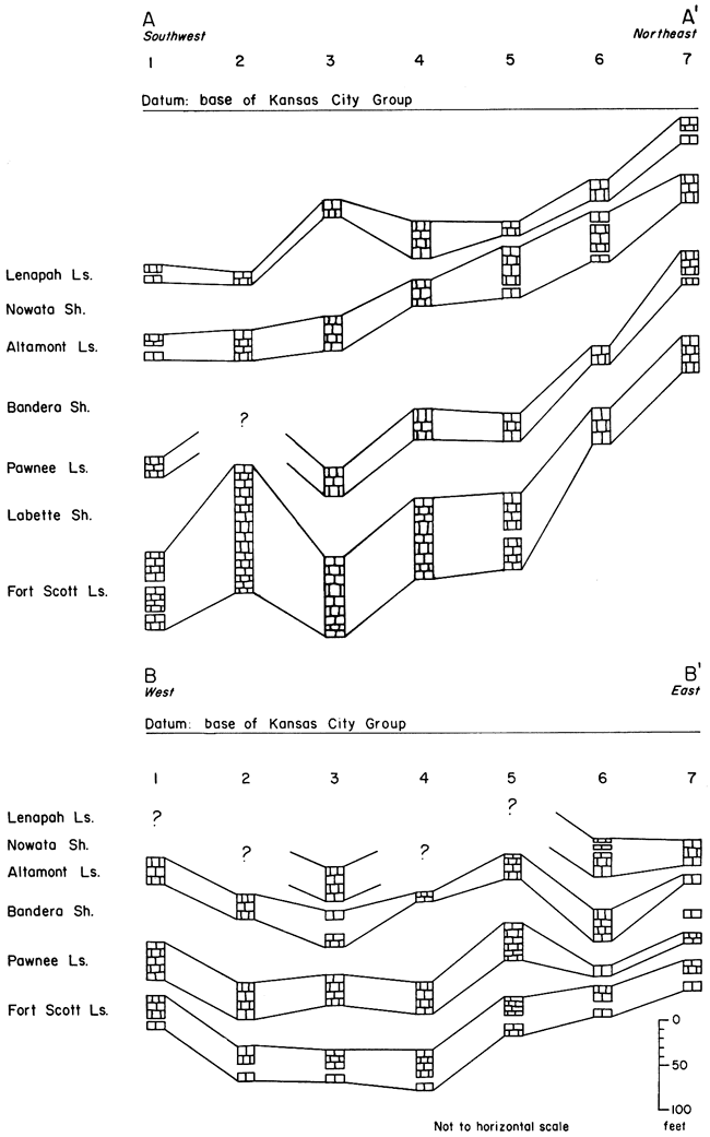
The Cherokee Group is the lowest major division of the Desmoinesian Series. Everywhere in Kansas, except where Atokan rocks are present, the Cherokee consists of all Pennsylvanian beds between the base of Fort Scott and top of "Mississippi lime." Lithologically, the group is composed mostly of shale, some sandstone, and sandy shale and important coal beds. Limestone is rare. Howe (1956) recognized 17 formations in the Cherokee, aggregating 450 to 500 feet in total thickness at outcrops in southeastern Kansas. The lower six formations were grouped in the Krebs Subgroup; the overlying Cabaniss Subgroup contained the other 11 formations. Later, Jewett (1959) used the terms Krebs and Cabaniss to refer to formations of the Cherokee Group. The issue regarding the stratigraphic rank of Krebs and Cabaniss is not settled; however, this makes little difference here because it is not possible to recognize the units in the subsurface, regardless of whether they are termed formations or subgroups. It is common practice at present for subsurface geologists to "lump" all Cherokee beds together.
The geologic history of eastern Kansas during Cherokee time and the relation of Cherokee beds to those in Oklahoma were pointed out by Weirich (1953). The correlation between Cherokee beds in Kansas and Oklahoma was discussed by Branson (1957). Distribution of earliest Pennsylvanian sediments on the older Mississippian rocks was shown by Wanless (1957). The lower part of the Cherokee Group in the Forest City Basin may be Atokan in age (Branson, 1962; Searight, 1959). The Pennsylvanian sea advanced from the south onto an eroded surface of Mississippian and pre-Mississippian rocks. Material derived from the erosion of these Paleozoic and Precambrian rocks, especially from the newly uplifted Nemaha granite ridge, which formed a low chain of hills, was dumped into the downwarped adjacent areas and was reworked by the advancing sea. The area was near sea level, as shown by coal and other swamp deposits, and the sequence of geologic events resulted in a series of cyclic deposits, in which were incorporated the famous shoe-string sands (Bass, 1936), long narrow channel fillings or bar deposits. Cherokee deposits essentially filled the basinal areas formed by the upwarping of anticlinal elements near the end of Mississippian time, as shown by their configuration and nature.
In western Kansas, Cherokee strata overlie rocks ranging in age from Precambrian to Atokan. The Marmaton Group, which consists mostly of limestone and shale, conformably overlies the Cherokee.
A southwest-northeast cross section from Kearny County to Ellis County (Fig. 70) shows the stratigraphic relations of Cherokee rocks to older and younger units. The Central Kansas Uplift is evident to the northeast, and Cherokee rocks are shown to abut against this positive uparched element. Toward the southwest, away from the uplift, the Cherokee thickens into the Hugoton Embayment. Near the uplift the Cherokee is composed mostly of clastic material, whereas farther southwestward in the embayment it consists mostly of limestone and black shale. Basal sands are present locally.
Figure 70--Southwest-northeast cross section from Kearny County to Ellis County showing stratigraphic relation of Cherokee rocks to younger and older units southwest of Central Kansas Uplift (from Goebel and Merriam, 1957). An Acrobat PDF version of this figure is available.
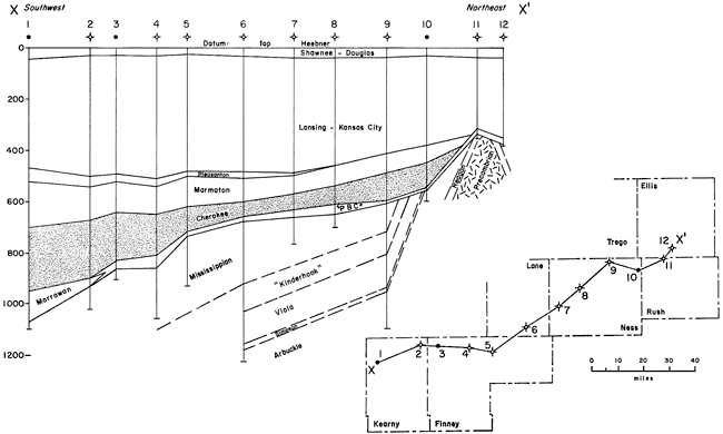
A northwest-southeast cross section from Ness County to Barber County (Fig. 71) roughly parallels the trend of the Central Kansas Uplift. Near the southeastern end of the section the Pratt Anticline is evident because the Cherokee does not extend across it. Other structural "highs" are revealed by thin Cherokee over their crests.
Figure 71--Northwest-southeast cross section from Ness County to Barber County showing stratigraphic relation of Cherokee rocks to younger and older units (from Goebel and Merriam, 1957). An Acrobat PDF version of this figure is available.
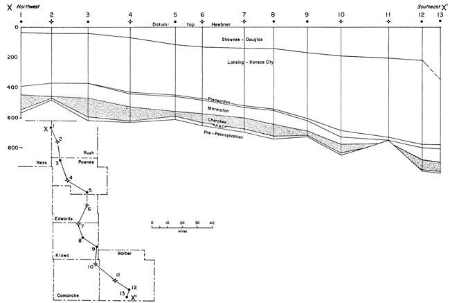
Correlation and proper age placement of the pre-Desmoinesian units in Kansas is at best poorly known; at least, very little has been published on these beds. For the most part they are confined to deeper parts of basinal areas, especially the Hugoton Embayment.
Distribution of Morrowan beds, as interpreted by McManus (1959), is shown in Figure 65. Distribution of these sediments and comments concerning them. have also been given by Moore (1949a), Moore and others (1951a), Maher and Collins (1952, 1953), and Beebe (1957). [Note: Rascoe (1962) recently published a comprehensive paper on Pennsylvanian and lower Permian rocks of southwestern Kansas and adjacent areas.]
Moore and others (1951a) have the following to say about Atokan rocks in Kansas: "Rocks ranging in thickness from a featheredge to about 500 feet and encountered at a depth of about 4,500 feet in southwestern Kansas are assigned to the Atokan Series. These rocks comprise chiefly limestone and shaly limestone. The Atokan deposits are separated from overlying Desmoinesian rocks and from underlying Morrowan deposits by unconformities." They say the following in regard to the Morrowan: "In Kansas rocks of Morrowan age are known only in the southwestern part of the State, at a depth of about 5,500 feet. These rocks, in part classified as the Kearny formation, comprise shale, limestone, and sandstone. The maximum thickness in Kansas is about 350 feet."
Thompson named the Kearny Formation in 1944 ". . . for the 127 feet of rocks encountered between the base of the producing sand at a depth of 4,752 feet and the top of the highly oolitic limestone believed to be of Mississippian age at a depth of 4,879 feet in the Stanolind Oil and Gas Company No. 1 Patterson well. The name is derived from Kearny county in which the well is located." Rocks in this well were assigned a Morrowan age by Thompson mainly on the basis of their fusulinid faunas, which include several species of Millerella. McManus (1959) was able to recognize two members in the Kearny, a lower one, chiefly of sandstone and limestone, and an upper one of shale containing limestone and sandstone. He found that the underlying Chesteran rocks were difficult to differentiate from the Kearny. Atokan rocks of the region are principally interbedded dark-gray, black, and dark-brown cherty limestone and dark-gray to black shale. Some fine-grained sandstone is present (McManus, 1959, p. 111).
The contact of the Pennsylvanian and Mississippian is unconformable. Older Pennsylvanian rocks are confined to the basinal areas and progressively younger rocks overstep higher and higher on adjacent upwarped areas.
Erosion at and near the end of Mississippian and during early Pennsylvanian time reduced the Mississippian surface to a peneplain as crests of anticlines were truncated, leaving a greater thickness of Mississippian deposits preserved in synclines. The surface was deeply weathered, and solution features developed locally. Lee (1939, p. 10) reported of the Mississippian surface:
Chert deposits occur on the eroded surface of the Mississippian limestones. The chert was accumulated during the weathering of the Mississippian and a portion of it was reworked during the invasion of the early Pennsylvanian sea. The weathered chert that has remained in place in the Mississippian limestones is, of course, Mississippian in age, and the chert that was reworked by the Cherokee sea is classed as detrital deposits of Pennsylvanian age. Unless well samples are studied with the aid of a microscope, however, no distinction can be made between chert weathered in place and the reworked chert of Pennsylvanian age, and even where samples are studied, chert weathered in place, residual chert and reworked chert are not everywhere distinguishable. For this reason, although it is recognized that part of the chert at the top of the Mississippian is really the basal deposit of the Pennsylvanian, it has been necessary to consider the top of the chert as the top of the Mississippian in compiling data. . . . Also, relatively few well samples of these rocks from the eastern part of the area are available for study.
These deposits are differently named, depending mostly on the area; however, generally speaking, they are called "Mississippi chat" in eastern Kansas, "Gorham" or "Burgess" sand or "Sooy" conglomerate in the central part, and Pennsylvanian basal conglomerate ("PBC") or Pennsylvanian basal sand in the far west.
In most places it is not possible by examination of well samples to differentiate the reworked material (Merriam, 1960d). The material may be of different ages, ranging from late Mississippian to Desmoinesian.
Mississippian or Devonian and Mississippian Deposits in Eastern Kansas
Mississippian rocks in eastern Kansas have long been recognized as economically important, not only for petroleum reserves but also on account of their metalliferous deposits. In the Tri-State District (Kansas, Missouri, and Oklahoma), large quantities of lead and zinc have been mined since the late 1800s. Thus, Mississippian rocks were of commercial importance in the eastern part of Kansas more than a half century before discovery of oil in them.
Information about Mississippian rocks in northeastern Kansas, except for local areas, is sparse. Usable information, accumulating slowly as a result of oil and gas exploration, generally has been disappointing. On the other hand, considerable data is available for southeastern Kansas, as petroleum was discovered in Mississippian rocks in Chautauqua and Montgomery Counties prior to 1917 (Moore and Haynes, 1917, p. 195). Subsequent drilling has yielded a mass of data, although much of it is of doubtful value. Mississippian rocks are present throughout eastern Kansas, except on higher parts of the Nemaha Anticline (Fig. 72).
Figure 72--Map of Kansas showing surface and subsurface distribution of Mississippian deposits.
Character--The Chesteran Series unconformably overlies the Meramecian in the southeastern part of Kansas (Table 2). In Cherokee County about 20 feet of limestone of Batesville age rests unconformably on the Warsaw (Lee, 1940).
Table 2--Classification of Mississippian units in Kansas (adapted from Moore and others, 1952).
| System | Series | Formation |
|---|---|---|
| Pennsylvanian | ||
| Mississippian | Chesteran | |
| Meramecian | Ste. Genevieve Limestone St. Louis Limestone Salem Limestone Warsaw Limestone Cowley Formation |
|
| Osagian | Burlington-Keokuk Limestone Reeds Spring Formation St. Joe Limestone |
|
| Kinderhookian | Gilmore City Limestone Sedalia Dolomite (Northview Shale) Chouteau Limestone (Compton Limestone) Boice Shale |
|
| Mississippian or Devonian |
Chattanooga Shale | |
| Silurian-Devonian |
The Warsaw contains a distinctive microfossiliferous chert that makes it easily recognizable. At the base of the Meramecian is placed the controversial Cowley Formation, which consists chiefly of dark silty limestone and dolomite. This unit may comprise deposits filling a southern Kansas basin cut into rocks of Osagian age or may represent a southern facies of other formations. The Salem, St. Louis, and Ste. Genevieve Limestones have been collectively termed Watchorn Formation where it was not convenient to differentiate the subdivisions of the upper part of the Meramecian (Lee, 1940, p. 10).
Unconformably underlying the Meramecian are beds of the Osagian Series, comprising (in descending order): Keokuk Limestone, Burlington Limestone, Reeds Spring Formation, and St. Joe Limestone. They are difficult to differentiate from one another except by the characters of included cherts.
In descending order the formations in the Kinderhookian are Gilmore City Limestone, Sedalia Dolomite, Northview Shale, and Compton Limestone (Lee, 1940). The Gilmore City, consisting of white semigranular limestone that is oolitic in most places, is probably the most distinctive unit of this Kinderhookian sequence. The Boice Shale, if present, is not recognized in southeastern Kansas (Reed, 1946).
Criteria for recognizing the different units of the Mississippian in the subsurface are mainly differences in insoluble residues. Early workers (Fowler, 1933; Hiestand, 1938) used only letter designations for subdividing the Mississippian, but subsequent studies, especially by Lee (1940), revealed that formational units could be recognized in the subsurface, and subsequently surface terminology from the adjoining states of Missouri and Oklahoma was applied in Kansas.
Underlying the Kinderhookian is the Chattanooga Shale, often called "Kinderhook shale," which may be either Devonian or Mississippian in age (Fig. 73). Because of the unconformity separating the Chattanooga from older rocks and the apparently conformable contact with overlying rocks, it is convenient to consider the Chattanooga (though classified currently as Devonian or Mississippian) with the Mississippian. The Chattanooga is a silty, pyritiferous, black or dark-gray shale. Spores are commonly disseminated throughout the formation. In eastern Kansas the basal "Misener sandstone" is represented only by disseminated, rounded sand grains (Moore and others, 1951a, p. 111).
Figure 73--Map of Kansas showing subsurface distribution of Chattanooga shale.

Thickness--The thickness pattern of the "Mississippi lime" (Fig. 74) is considerably different from that of the Chattanooga Shale. It has long been recognized that in southeastern Kansas the thickness of the Mississippian is directly related to structure (Bass, 1929; Lee, 1939). Hence, northeast-trending thick and thin belts correspond to northeast-trending basinal and anticlinal structures (Merriam and Goebel, 1959c). This pattern is almost at right angles to that revealed by the thickness map of the Chattanooga (Fig. 75).
Figure 74--Isopachous maps of "Mississippi lime" in southeastern Kansas. Note north- to northeast-trending thick and thin areas, which coincide with known synclines and anticlines (from Goebel and Merriam, 1957). Contour interval 50 feet. An Acrobat PDF version of this figure is available.
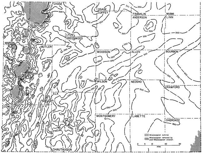
Little is known about outcropping Mississippian rocks in Kansas; rocks seemingly of Osagian age, and possibly also of Meramecian age, crop out in Cherokee County, in extreme southeastern Kansas (Smith and Siebenthal, 1907). Northwestward from there to the area of the Nemaha Anticline, the Mississippian alternately thickens and thins across synclines and anticlines, ranging in thickness from about 200 to 450 feet. In southern Woodson County the unit is cut by a granitic intrusive at Rose Dome and by the Hills Pond Peridotite at Silver City (Wagner, 1954). The Mississippian rocks have been completely eroded from the higher parts of the Nemaha Anticline in Chase, Marion, and Butler Counties. West of the Nemaha structure the Mississippian thickens into the Salina and Sedgwick Basins.
For the eastern part of the map control is sparse, but in the western part configuration of the contours is based on many well logs. In areas of scant control, the isopachous lines were sketched and thus actually are only form lines, but it is believed that the regional trends implied by the 50-foot contours are essentially correct.
Several minor anticlinal structures in southeastern Kansas are discernible on the map because the Mississippian thins over their crests. These include the Fredonia Dome, Longton Ridge, Dexter-Otto Anticline, and Winfield Anticline. After more wells are drilled in the area, some of these minor structures will be more precisely definable.
An isopachous map of the Chattanooga Shale and the Boice Shale, if present, and also possibly the Northview Shale where the Compton Limestone is absent, is presented in Figure 75. The thickness of this sequence, from the "Hunton" limestone or older formations to the base of the "Mississippi lime," ranges from a featheredge in extreme southeastern Kansas to approximately 200 feet in Marion County. The Chattanooga is absent in part of Chautauqua County; Lee (1940, p. 25) believed that it was removed by post-Osagian erosion. In Chase, Marion, and Butler Counties the Chattanooga has been removed by post-Mississippian erosion along the crest of the Nemaha Anticline. In two small areas in southern Woodson County, the intrusives at Rose and Silver City cut the unit.
Figure 75--Isopachous maps of Chattanooga Shale, Boice Shale where present, and northview Shale where Compton Limestone is absent in southeastern Kansas (from Goebel and Merriam, 1957). Contour interval 50 feet.
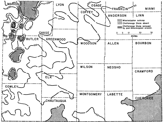
In general, thickness of the Chattanooga is irregular, increasing to the northwest. Four vague northwest trends of thinning cross Coffey County and east-central Lyon County, central Greenwood County, central Elk County and southeastern Butler County, and central Cowley County, respectively. These areas of thinning may represent old structural trends, but the control for this map is not adequate to warrant such a conclusion. Discrepancies between this map and a similar one prepared by Lee (1940, pl. 3) are probably due to differences in well control available at time of construction of the maps.
Stratigraphic Relations--The locations of cross sections showing the relation of present structure to major post-Mississippian structural provinces in Kansas are shown in Figure 76.
Figure 76--Major pre-Desmoinesian post-Mississippian structural features of Kansas and location of cross sections shown in Figure 77.
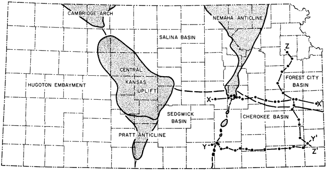
A west-east cross section (cross sections adapted from Lee and Merriam, 1954b) from Marion County on the west to Miami County on the east, shows the relation of Mississippian rocks to major structure (Fig. 77). Mississippian rocks dip gently westward into the Brownville Syncline but are sharply upturned and truncated adjacent to the Nemaha Anticline, giving the Forest City Basin an asymmetrical profile. On the western side of the cross section, Mississippian rocks dip gently westward into the Sedgwick Basin. Permian and Pennsylvanian beds arch over the anticline, revealing its presence. The gross exaggeration of the cross section gives a false impression as to the intensity of the structure; the maximum dip is only about 8 degrees on the eastern flank of the Nemaha.
Figure 77--Structural cross sections in eastern Kansas showing relation of Mississippian deposits to younger and older units. An Acrobat PDF version of this figure is available.
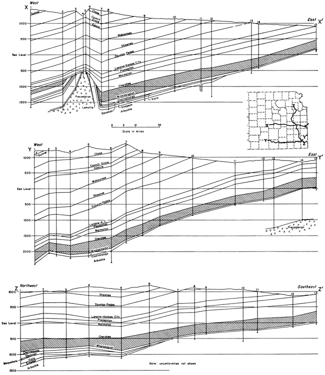
Another west-east cross section, which extends from Sumner County on the west to Crawford County on the east across the Cherokee Basin and Nemaha Anticline, is also shown in Figure 77. Mississippian rocks dip gently westward to the eastern flank of the Nemaha Anticline, where the dips are reversed and the Mississippian is arched over the structure. The anticline is weakly reflected in Pennsylvanian and Permian beds.
A third cross section extends northwest-southeast across the Forest City Basin, Bourbon Arch, and Cherokee Basin (Fig. 77). Mississippian rocks dip gently toward the northwest into the deeper part of the Forest City Basin. Although the section crosses the Bourbon Arch almost at a right angle, the position of this arch is not revealed.
Environment of Deposition--The environment of deposition of Mississippian rocks in Kansas was adequately summed up by Moore (1957a, p. 124) in a discussion of the carbonate deposits of the Ozark region:
In Mississippian time, as in many other parts of the Paleozoic era, very large epicontinental seas spread over the North American and other continental platforms and because these seas were bordered only locally by land sufficiently elevated to furnish clastic detritus, the waters were predominantly clear and probably moderately warm. Benthonic invertebrates and other marine organisms that secreted hard parts of calcium carbonate were widespread and their populations were prodigious. Relatively uniform, widely distributed limestone formations were made.
Mississippian Deposits in Western Kansas
In 1948 Clair was able to divide the "Mississippi lime" of western Kansas on the basis of lithology and by means of insoluble residues. His work serves as a guide to recognizing the Mississippian subdivisions. Many of the units of eastern Kansas are recognizable in the west, including the Chesteran, Meramecian, Osagian, and Kinderhookian (Veroda, 1959). These rocks have been described in some detail by Maher and Collins (1949), and Maher (1953b). Distribution of Mississippian deposits in Kansas is shown in Figure 72. Rocks classified as the Meramecian, Osagian, and Kinderhookian Series are represented in the Cambridge Arch area (Merriam and Atkinson, 1955).
In western Kansas several Mississippian formations are recognized to be present. The most distinctive of these are the Warsaw (Meramecian), Fern Glen and Burlington-Keokuk (Osagian), and Gilmore City (Kinderhookian). These rocks unconformably overlie "Kinderhook shale" and consist of white, dense, cherty or oolitic limestone. Present at the top of the Mississippian sequence is a residual chert, locally as much as 50 feet thick, which may be very latest Mississippian or earliest Pennsylvanian in age. The chert is white, smooth, and opaque to subopaque. This chert overlies progressively older beds to the northeast, and on the southwestern flank of the Cambridge Arch it overlies beds as old as Arbuckle. This same sort of situation, on a smaller scale, occurs on the eastern side of the Central Kansas Uplift, where according to Lee (personal communication), the chert is present but less well developed.
The "Kinderhook" is a green to brown shale that is present locally and is placed, as a matter of convenience, in the Mississippian rather than the Devonian. It is possible that this shale is Chattanooga or Boice or equivalent to one or both. The Chattanooga Shale is known to be thin on the western side of the Central Kansas Uplift and to be present farther south (Lee, 1953).
Lower Paleozoic Deposits
The stratigraphy of the lower Paleozoic rocks was not studied in detail except to plot accurately the areal distribution of the different units. Much important work remains to be done with these rocks, although study of them in Kansas must be entirely in the subsurface. These units, which crop out in adjacent states, will have to be traced into the subsurface in Kansas before correlations can be made with certainty. This has been done for only a few of the beds.
The pre-Mississippian rocks consist mainly of limestone and dolomite but they include some shale and sandstone. Rocks of Cambrian-Ordovician and Silurian-Devonian age are recognized; the thickest sections of these rocks occur near the centers of the different basins, where they have been preserved from extensive erosion. These rocks are missing from the crests of uplifts; hence, unconformities are widespread in this part of the section.
Much of the published knowledge regarding the pre-Pennsylvanian rocks in Kansas, and the Mississippian in particular, is the work of Wallace Lee, whose publications have been cited along with many others pertaining to this part of the stratigraphic column. Additional works that should be mentioned include those by: Aurin, Clark, and Trager (1921), Udden (1926), Twenhofel (1927), Edson (1929, 1935), Ver Wiebe (1946, 1948), and Taylor (1946, 1947a, 1947b).
Rocks, predominantly limestone and dolomite, of Devonian and Silurian age lie unconformably below the Mississippian and unconformably on Ordovician rocks. In places they overstep different Ordovician formations, but in general their structural attitude and distribution (Fig. 78) accord more closely with Ordovician than with Mississippian rocks. These commonly undifferentiated rocks are known as "Hunton"; however, Lee (1943, 1956) has shown that a disconformity separates Devonian and Silurian rocks. Like Mississippian rocks, the "Hunton" has been removed by erosion from the highest parts of the Nemaha Anticline, Central Kansas Uplift, and Chautauqua Arch; elsewhere in northeast and north-central Kansas (the North Kansas Basin), these rocks are present and attain a maximum total thickness of 650 feet (Jewett and Merriam, 1959). "Hunton" rocks are not known to be present elsewhere in the state, except in the northern part of the Sedgwick Basin in Harvey County and in parts of McPherson, Marion, Sedgwick, Butler, and Reno Counties. Small outliers of "Hunton" are known beyond the larger areas of occurrence (Lee, 1956).
Figure 78--Map of Kansas showing subsurface distribution of "Hunton" rocks (Silurian-Devonian).
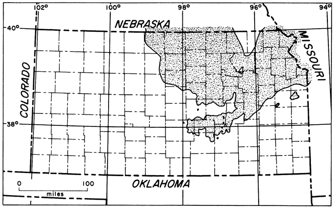
In Kansas and Missouri the contact between the Devonian and the Silurian occurs at the base of a dolomite or limestone zone in which rounded sand grains are disseminated; the basal Devonian bed is locally a dolomitic sandstone. The Devonian in eastern Kansas commonly includes gray to brownish, dense to finely crystalline dolomite or sublithographic limestone. Except where it is very thin, it includes some opaque white chert. Silurian rocks consist of light-gray to buff, fine- to medium-crystalline dolomite, which is locally very vuggy and porous. Chert is also present in various amounts. The base of the Silurian is characterized by large dolomitized oolites (Lee and Merriam, 1954b). In some wells arenaceous Foraminifera are found in the lower part of the Silurian portion of "Hunton" (H. A. Ireland, personal communication).
Cambrian-Ordovician rocks consist chiefly of dolomite but include some limestone, sandstone, and shale. Subdivisions are (in descending order): Maquoketa (Sylvan) Shale, Viola (Kimmswick) Limestone, Simpson Group (including St. Peter Sandstone), Arbuckle Group, Eminence Dolomite, Bonneterre Dolomite, and Reagan (Lamotte) Sandstone. The last three formations are of Late Cambrian age. These units unconformably overlie the Precambrian basement. The combined thickness of these rocks is about 1,500 feet, but in many places thinning due to a retarded rate of sedimentation, nondeposition, or erosion leaves as little as a few feet of these rocks. They, like other Paleozoic units, are absent from higher parts of the Nemaha Anticline, Central Kansas Uplift, and Cambridge Arch.
The Maquoketa Shale (Upper Ordovician) is gray-green to gray silty dolomitic shale and gray fine-granular silty dolomite. It is locally cherty. The Maquoketa attains a maximum thickness of about 155 feet. In the extreme southeastern part of the Hugoton Embayment, Maquoketa has been reported from several wells, but the exact extent, distribution, and correlation of the shale are not known with certainty.
The Viola Limestone (Middle Ordovician) consists of gray, buff, and brown medium- to coarse-crystalline dolomite, which is vuggy and contains various amounts of gray and white opaque, generally spicular chert. In the northeastern part of Kansas (Lee, 1943) the formation attains a maximum thickness of about 310 feet. In the Hugoton Embayment the Viola oversteps the underlying Simpson Group and older rocks both eastward (Merriam and Atkinson, 1955) and westward (Maher and Collins, 1949). The formation is absent in the northwestern corner of Kansas and along the southwestern flank of the Cambridge Arch and Central Kansas Uplift (Fig. 79). In a small area in northwestern Pawnee County, the Reagan, Arbuckle, and Simpson are missing and the Viola is in direct contact with Precambrian rocks.
Figure 79--Map of Kansas showing subsurface distribution of Viola Limnestone (Middle Ordovician).
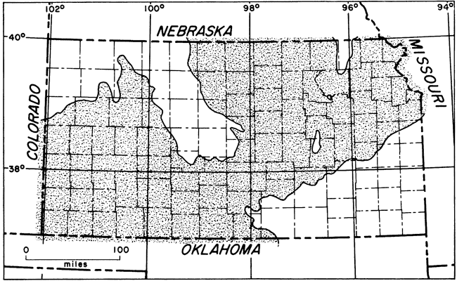
In Kansas the Simpson Group is divided into two formations: the Platteville Formation (upper), and the St. Peter Sandstone (lower). Distribution of this group is shown in Figure 80. A map showing distribution of the group in parts of five states--Nebraska, Kansas, Missouri, Iowa, and Illinois--has been published by Lee and others (1946). A detailed description and correlation of the rocks of Simpson age in Kansas has been given by Leatherock (1945).
Figure 80--Map of Kansas showing subsurface distribution of Simpson Group (Middle Ordovician).
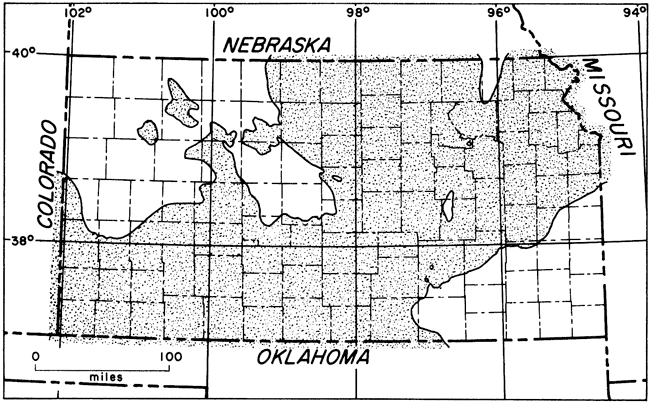
The Platteville Formation consists of green shale, limestone, dolomite, and sandstone. A bed in this formation that may be used for correlation is a persistent basal dolomite, which ranges in thickness from 5 to 35 feet (Leatherock, 1945). The formation as a whole is characterized by lateral changes. The maximum thickness of the formation is about 104 feet (Leatherock, 1945, p. 13). Twenhofel and others (1954) assign a Blackriveran age to the Platteville.
According to Leatherock (1945), the St. Peter Sandstone consists of three zones: upper and lower zones of sandstone and a middle zone of green clay shale. The St. Peter is composed of white, fine to medium, well-rounded frosted quartz sand. It is loosely cemented with calcareous cement, but in well samples it may occur as loose sand grains. The sand is locally stained reddish by minor amounts of iron oxide in the cement. The normal thickness of the St. Peter in eastern Kansas is 10 to 84 feet (Leatherock, 1945, p. 11). According to Twenhofel and others (1954), the St. Peter is Chazyan in age.
The Simpson Group unconformably overlies the Arbuckle Group and in an area on the Southeast Nebraska Arch it overlies rocks as old as Precambrian. Any one of the three zones of the St. Peter may be in contact with the Arbuckle. The Platteville in turn unconformably overlies the St. Peter Sandstone, so that it too may be in contact with any one of the three zones. Likewise, the Kimmswick (Viola) Limestone unconformably overlies the Platteville Formation. These relations are shown on a series of stratigraphic cross sections published by Leatherock (1945, pl. 1).
Simpson-filled Sinkholes in Eastern Kansas
Sinkholes in eastern Kansas filled with Simpson rocks have been mentioned by Lee and others (1946), Lee, Leatherock, and Botinelly (1948), and Lee and Merriam (1954b). In west-central Missouri it is possible to observe on the surface a similar sinkhole filled with Simpson (St. Peter) rocks near Otterville, Cooper County (Kansas Geological Society, 1941), and there are many others.
Examination of logs of wells drilled in eastern Kansas revealed six wells that penetrated abnormally thick sections of Simpson (Merriam and Atkinson, 1956). The six wells are (Fig. 81): (A) Kasper No. 1 James in Johnson County (sec. 8, T. 13 S., R. 25 E.); (B) Clark No. 1 Vaughn in Miami County (sec. 28, T. 17 S., R. 22 E.); (C) Cram No. 1 Allen in Coffey County (sec. 13, T. 21 S., R. 15 E.); (D) Herbel and Tyrell No. 1 Henning in Coffey County (sec. 22, T. 21 S., R. 16 E.); (E) Evan et al No. 1 Cook in Linn County (sec. 4, T. 22 S., R. 24 E.); and (F) Sinclair-Prairie No. 9 McClaskey in Woodson County (sec. 29, T. 23 S., R. 14 E.). Samples were available from only four of them. A sample log, which had been prepared by Hundhausen and Grohskopf, was available for the Clark No. 1 Vaughn well. In the absence of samples or a sample log for the Herbel and Tyrell No. 1 Henning well, information had to be obtained from a drillers log.
Figure 81--Isopachous map of Simpson Group in eastern Kansas (from Merriam and Atkinson, 1956). Contour interval 50 feet. Letters refer to rest wells identified in text.
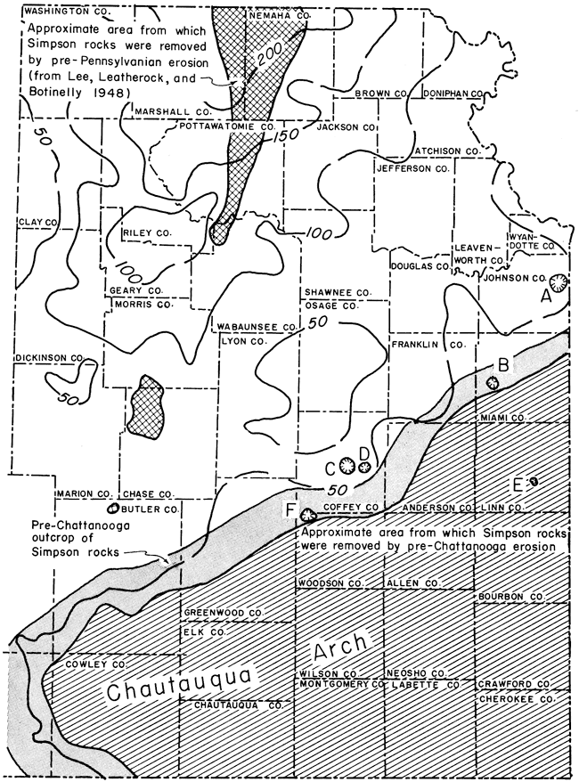
Because of the scarcity of wells that have been drilled as deep as the Arbuckle in this region, as many as six sinkholes is somewhat surprising and would seem to indicate the presence of extensively developed solutional features in Arbuckle rocks in eastern Kansas. Because information is decidedly scanty, it is difficult to make exact interpretations, but available data perhaps warrant a few preliminary statements.
The term "abnormal thickness" is relative, depending on local conditions. For example, in the Evan et al No. 1 Cook well, 40 feet of Simpson is regarded as abnormal because no Simpson is present in any nearby wells in Linn County. The thickest known section of Simpson in eastern Kansas is 465 feet in the Kasper No. 1 James well. Normal sections of the Simpson range in thickness from about 35 to 170 feet (Leatherock,1945).
An isopachous map of the Simpson Group in eastern Kansas, contoured at 50-foot intervals, shows roughly the outline of part of the North Kansas Basin and Chautauqua Arch (Fig. 81). The pre-Chattanooga outcrop pattern of the Simpson Group outlines the northwestern, western, and part of the southwestern flanks of the Chautauqua Arch. Thickness of Simpson rocks increases to the north into the North Kansas Basin. Because both the upper and lower boundaries of the group are erosional, the contours are irregular. If control were more detailed, the contours would be even more irregular.
The sinkholes seem to be definitely related to the pre-Chattanooga subcrop pattern of the Simpson Group along the northern flank of the Chautauqua Arch (Fig. 81); no abnormally thick Simpson was found at any appreciable distance downdip from the subcrop. Updip, the St. Peter in Miami County is probably an erosional remnant preserved in a sinkhole.
Considering all possibilities, sinkholes seem the most plausible explanation for these areas of thick St. Peter sediments. No deep channeling (on the order of 400 feet) of the pre-Simpson surface has been recognized either on the surface in Missouri or in the subsurface in Kansas. Distribution of the anomalies parallel to the pre-Chattanooga Simpson subcrop also suggests sinks rather than channeling. Channels would tend to develop perpendicular to the structure and to diverge from the crest of the Chautauqua Arch; the present known distribution does not simulate drainage patterns. Also, there is apparently a similarity between the Otterville surface feature in Missouri and the sinkholes in the subsurface of eastern Kansas.
One possible explanation for distribution of the sinkholes is that the Arbuckle was subjected to solution on the flanks of the rising Chautauqua Arch but not in the deeper part of the North Kansas Basin. Until more evidence is accumulated, however, this explanation is only tentative. Because the Platteville Formation is not involved in the sinkholes, they are at least pre-Platteville in age; probably they are pre-St. Peter (or pre-Simpson).
The "Arbuckle Group" of Late Cambrian and Early Ordovician age consists of five recognizable divisions in the subsurface of eastern Kansas (Lee and Merriam, 1954b). The lower two, Bonneterre Dolomite and Eminence Dolomite, are Cambrian in age, whereas the upper three, Gasconade Dolomite, Roubidoux Dolomite, and undivided Cotter and Jefferson City Dolomites, are of Ordovician age. Correlation of the upper Arbuckle from Missouri into Kansas has been made by McCracken (1955).
Definitions of the Arbuckle differ considerably; the name is used herein to designate collectively all rock units between the overlying Simpson Group and underlying Reagan or Lamotte Sandstone. Other authors variously exclude the Bonneterre or both the Bonneterre and Eminence from the group; in the latter case the group is restricted to rocks of Ordovician age, and the Gunter Sandstone is the lowest unit in the group. Distribution of Arbuckle rocks is shown in Figure 82.
Figure 82--Map of Kansas showing subsurface distribution of Arbuckle Group (Cambrian-Ordovician).
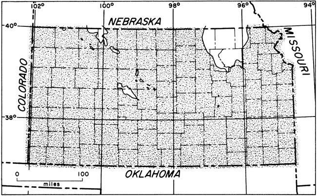
The Arbuckle Group as a whole consists mainly of dolomite and is white, buff, light gray, cream, and brown. The rocks are mainly crystalline or dense, and especially in the upper parts they contain large amounts of various types of chert. Some of the beds are sandy and some contain minor amounts of glauconite and pyrite. Where the Lamotte Sandstone is missing, Arbuckle rocks overlie the Precambrian surface. In general, the Arbuckle thickens to the east and southeast toward the Ozark region of Missouri and toward the south in Oklahoma.
The Arbuckle in the vicinity of the Cambridge Arch (Merriam and Atkinson, 1955) consists mostly of gray to buff, dense or porous and vuggy, medium- to coarse-crystalline limestone and dolomite. Some of the rocks contain light-gray subopaque chert or oolitic chert. Many of the beds are glauconitic. Where Reagan Sandstone is absent, Arbuckle lies directly on the Precambrian surface (Fig. 83).
Figure 83--West-east cross section, based on logs of Kansas Sample Log Service, across Cambridge Arch showing relation of lower Pennsylvanian rocks to older beds on crest of arch. Where Reagan is absent, Arbuckle is in direct contact with underlying Precambrian (from Merriam and Atkinson, 1955). An Acrobat PDF version of this figure is available.
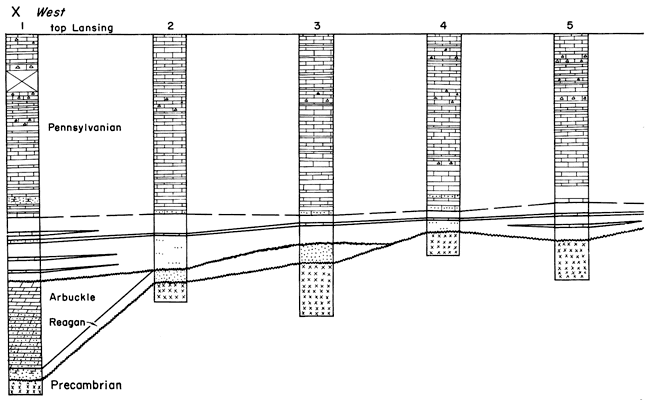
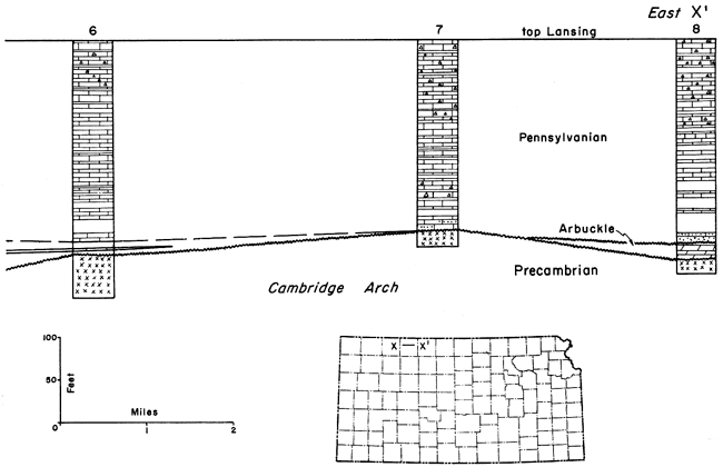
It is probable that most of the rocks reported as Arbuckle in western Kansas are or are equivalent to the Bonneterre Dolomite, although the Bonneterre is not recognized by some as part of the Arbuckle Group. This is also the opinion expressed by Maher and Collins (1949). In a note on a log of the Kansas Sample Log Service, of a well drilled in Rawlins County (sec. 21, T. 3 S., R. 32 W.), R. A. Carmody stated that the Arbuckle was topped at 4,694 feet and Bonneterre or equivalent at 4,800 feet. The rocks above the Bonneterre he believed to be pre-Roubidoux and probably Late Cambrian in age. However, it is not clear to what formation these rocks should be assigned in the classification, although presumably they belong to the Eminence Dolomite, as the Eminence is recognized in western Kansas (Moore and others, 1951a).
Where the Arbuckle was exposed to erosion on and along the flanks of uparched areas such as the Cambridge Arch, the dolomite and limestone were deeply weathered. It is this weathered zone, where more porosity and permeability . were developed, that forms petroleum reservoirs.
Arbitrarily, the term Lamotte is used in eastern Kansas and Reagan in western Kansas to indicate clastic beds, chiefly sandstone, that occur beneath the Arbuckle Group. The Lamotte is a basal Paleozoic sand (Late Cambrian), which was deposited on a surface of moderate relief; some local areas were too high to be submerged during Lamotte deposition but in some areas the unit is as much as 130 feet thick.
In western Kansas the Reagan is composed of fine to coarse, angular to rounded, poorly sorted quartz grains. It is assumed to have been deposited continuously over the Hugoton Embayment, because it has been found in all wells drilled deep enough to encounter it (Merriam, 1955b). In the vicinity of the Cambridge Arch the sandstone is composed of white to gray, medium to coarse, angular to subrounded, frosted quartz grains. In places the formation is dolomitic and in places it contains traces of glauconite. Locally the formation is missing where it has been removed by post-Reagan erosion or where it was not deposited.
Prev Page--Stratigraphy--Mesozoic || Next Page--Stratigraphy--Igneous
Kansas Geological Survey, Geologic History of Kansas
Comments to webadmin@kgs.ku.edu
Web version Jan. 14, 2009. Original publication date Dec. 1963.
URL=http://www.kgs.ku.edu/Publications/Bulletins/162/03_strat_c.html