![]()
Prev Page--Major Unconformities || Next Page--Present Structure
Tectonic Framework
Compared with that in some parts of the world, the structural geology in Kansas is very simple. Kansas is located on a platformlike extension of a large, stable craton. Because this situation has prevailed since the end of the Precambrian, only a thin mantle of sedimentary rock covers the basement complex. This Precambrian basement complex is nothing but an extension of the large continental nucleus, the Canadian Shield, which is exposed farther north in Canada and in the north-central and northeastern United States. The sedimentary rocks, consisting of many thin units, rest nearly parallel on one another. This uncomplicated rock arrangement has simplified the task of exploring for valuable underground minerals in Kansas.
Pre-Mississippian structures are difficult to recognize because deformation subsequent to their original formation commonly has altered their shape and configuration considerably. The existing rock record, however, allows reconstruction with reasonable accuracy of the generalized pre-Mississippian Paleozoic tectonics (Fig. 100A).
Figure 100--Major structural features of Kansas: A, pre-Mississippian post-Devonian; B, pre-Desmoinesian post-Mississippian; C, Mesozoic.
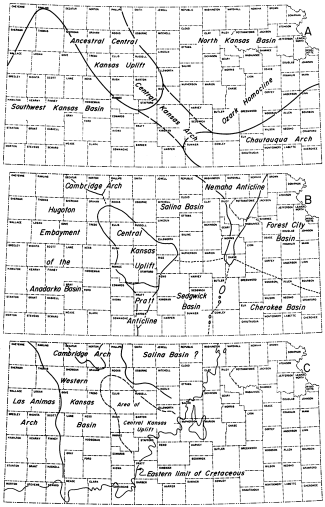
A major change in structural development of the Kansas region took place near the end of Mississippian time. Many of the structures that began to develop near the end of the Mississippian or beginning of the Pennsylvanian now define the structural framework evident in Paleozoic beds. Post-Paleozoic movements did not materially alter these pre-Desmoinesian post-Mississippian structures (Fig. 100B).
Because Mesozoic deposits are absent in eastern Kansas, the interpretation of Mesozoic structures is restricted to those in western Kansas (Fig. 100C). Figure 100 shows the nearly complete change in structural development near the end of the Paleozoic.
After, and possibly during, deposition of a vast sheet of rock debris over eastern Colorado and western Kansas during Tertiary time, the area was tilted eastward. The structure forming the Great Plains is essentially an eastward-dipping homocline, with minor irregularities superimposed on the major structure.
The following are former or present major structural features in Kansas.
Ancestral Central Kansas Uplift--The ancestral Central Kansas Uplift is a term sometimes used for the early Paleozoic development of the Central Kansas Uplift.
Barton Arch--The names Barton Arch and Central Kansas Uplift are applied to the same pre-Desmoinesian post-Mississippian structure. Although Barton Arch has priority over Central Kansas Uplift, the latter name is most widely used and is accepted here.
Bourbon Arch--This is a low, indistinct, seemingly uparched feature that trends almost east-west in eastern Kansas through parts of Bourbon, Allen, Anderson, Coffey, Woodson, Lyon, and Chase Counties, separating the Forest City Basin on the north from the Cherokee Basin on the south. It is supposedly pre-Desmoinesian post-Mississippian in age.
Although its limits are vague, this arch can be construed to cover about 3,000 square miles (Merriam and Goebel, 1956; Baker 1962). McMillan (1956) concluded that the arch exerted some influence on sedimentation as late as Late Pennsylvanian. Both Pennsylvanian and Permian beds crop out over the arch; subsurface strata are similar to the sequence in the Forest City Basin.
For a very brief time, then, the Bourbon Arch separated two areas, the Forest City and Cherokee Basins, that were accumulating sediments; but it should be remembered that in Middle and Late Pennsylvanian time sediments were being deposited over a vast area in middle North America, and it is misleading to place too much emphasis on an individual divide.
Cambridge Arch--The southern end of the Cambridge Arch (sometimes called Darton's Arch) is located in Norton and Decatur Counties, so that this structure covers only about 1,000 square miles in western Kansas. It is a large, northwest-trending anticlinal feature that extends northward into Nebraska and is separated by a structural saddle from the Central Kansas Uplift to the southeast. Also on the same trend as the Cambridge Arch and Central Kansas Uplift are the Chadron Arch of Nebraska and the Chautauqua Arch in southeastern Kansas; all of them together form an arcuate trend of uparched features, which in plan view are convex toward the southwest. Structural movement occurred along the Cambridge Arch in pre-Mississippian and in pre-Desmoinesian post-Mississippian, as well as in Mesozoic time. The Salina Basin flanks the structure on the east, and the northern end of the Hugoton Embayment limits the western side.
Surface rocks along the Cambridge Arch are Tertiary and Cretaceous in age. On the crest of the structure in the subsurface, Precambrian rocks are overlain by strata of Pennsylvanian age; older Paleozoic rocks are upturned, truncated, and overstepped on the flanks. The Precambrian surface plunges southeastward and slopes both northeastward and southwestward. In southeastern Norton County the plunge is reversed to form a low, broad saddle that separates the Cambridge Arch proper from the Central Kansas Uplift. Distribution of Precambrian rock types gives a vague suggestion that the granite might have intruded into older preexisting sediments (Merriam and Atkinson, 1955, p. 3).
The arch is flanked by several smaller, parallel anticlinal and synclinal structures. The Stuttgart-Huffstutter Anticline on the east is separated from the Cambridge Arch by the northerly plunging Long Island Syncline. On the west side of the arch, the Jennings Anticline is a subsidiary feature which plunges southward.
Central Kansas Arch--This term has been used to include the ancestral Central Kansas Uplift and the Chautauqua Arch.
Central Kansas Uplift--The name Central Kansas Uplift (also called the Barton Arch or Russell Arch) has been used widely for a major pre-Desmoinesian post-Mississippian structural feature in central Kansas (Morgan, 1932). The northwest-trending uplift, outlined by the extent of Mississippian beds, separates the Hugoton Embayment on the west from the Salina and Sedgwick Basins on the east.
The Central Kansas Uplift is the largest positive feature in Kansas, occupying an area of about 5,700 square miles entirely within the state. Surface formations of Cretaceous, Tertiary, and Quaternary age mask the underlying structure of the deeper and older beds, inasmuch as structural development of the uplift was concluded before Mesozoic time. Near the southern end of the province a large area is covered with Pleistocene dune sand.
The section of sedimentary rocks over the structure is in most areas less than 5,000 feet thick. On the crest of the structure, Precambrian rocks are overlain by Pennsylvanian sediments; on the flanks of the uplift, pre-Pennsylvanian strata are upturned, truncated, and overstepped by Pennsylvanian beds. A fairly representative section of Permian rocks that extends across the structure includes evaporite deposits, especially the Hutchinson Salt. The Precambrian complex consists of a variety of igneous and metamorphic rocks. A great deal of subsurface information is available in this area because many wells have been drilled to the basement rocks.
Along the crest and flanks of the uplift are many subsidiary, although important, structures, including prominent anticlinal features known as the Ellsworth Anticline, Fairport Anticline, Pawnee Rib, Rush Rib, and Russell Rib. The Geneseo Uplift, located in parts of Rice, Ellsworth, and McPherson Counties, is a semidetached, easternmost lobe of the Central Kansas Uplift (Clark, Arnett, and Royds, 1948).
Chautauqua Arch--This is a pre-Mississippian anticlinal extension of an early phase of the Ozark Uplift into southeastern Kansas. It was a broad, uparched, westward-trending feature, and over its crest units as young as Pennsylvanian lie on rocks as old as Cambrian-Ordovician.
The arch began to rise at about the time the North Kansas Basin began to subside; but then Silurian rocks, and later Devonian rocks, were deposited, arched, and eroded, and rocks as old as Arbuckle were exposed, before deposition of the Chattanooga Shale. Mississippian strata were deposited over the area, and the post-Mississippian Cherokee Basin formed in the area of the Chautauqua Arch, indicating that structural development of the arch had been concluded by this time.
Cherokee Basin--The shallow Cherokee Basin (infrequently called the Pryor Basin) developed on the older Chautauqua Arch in pre-Desmoinesian post-Mississippian time. It is an extension of the McAlester or Arkoma Basin of Oklahoma into southeastern Kansas. The northern part of the basin is separated from the Forest City Basin by the Bourbon Arch, and the western side is bounded by the Nemaha Anticline.
The Cherokee Basin is slightly smaller than the Forest City Basin, covering about 8,400 square miles. Surface rocks dip gently westward, except on small anticlines and near the Nemaha Anticline, where a slight reversal of dip reveals its presence. Mississippian rocks, the oldest exposed in Kansas, crop out in Cherokee County, in the extreme southeastern corner of the state. Pennsylvanian and Permian rocks are exposed over the rest of the basin. These sediments undergo facies changes southward into Oklahoma, making correlation of individual beds difficult. The maximum sedimentary sequence is about 3,500 feet thick.
Lower Pennsylvanian beds overlie Cambrian-Ordovician and Ordovician throughout most of the basin. Pre-Pennsylvanian history is that of the Chautauqua Arch. In Pennsylvanian time the Cherokee Basin was formed by mild downwarp. The Precambrian surface does not reflect this basinal structure.
Dodge City Basin--The name Dodge City is occasionally used to differentiate a large structural feature in southwestern Kansas, better known as the Hugoton Embayment. Although the name Dodge City has priority, Hugoton has gained wide acceptance in recent years.
Ellis Arch--The pre-Mississippian structural development of the Central Kansas Uplift and Cambridge Arch has been designated the Ellis Arch. This anticlinal feature is a finger extending from the large Transcontinental Arch, which reached southwestward from Wisconsin through South Dakota and Nebraska (Eardley, 1951). Several periods of uplift affected the Ellis Arch; the strikes of anticlinal folds in pre-Pennsylvanian rocks differ about 20 degrees from the mid-line of the later uplift. These anticlinal folds are interpreted as pre-Mississippian in age, because they are aligned with folds on the Chautauqua Arch and because they seem to be related to features older than the Central Kansas Uplift (Moore and Jewett, 1942).
Forest City Basin--Most of the Forest City Basin is located in Iowa, Missouri, and Nebraska; only the extreme southwestern corner lies in Kansas. The basin is the third largest in the Kansas region; its area slightly exceeds 9,500 square miles. It is bounded on the west by the Nemaha Anticline and on the southwest by the Bourbon Arch. The axis of the basin trends slightly east of north; it lies close to and parallels the axis of the Nemaha Anticline. The proximity of the basinal axis, the Brownville Syncline (Condra, 1927), to the Nemaha produces a relatively steep west flank, a gentle east flank, and an asymmetrical profile. The basin was a depositional area after Arbuckle time, first as part of the older North Kansas Basin and then as a separate feature.
Pennsylvanian and Permian strata, exposed at the surface along the southern side of the basin, have a gentle westward dip of 20 to 30 feet per mile, forming part of the Prairie Plains Homocline. Local anomalies are observed and mappable in surface beds. Numerous small, faults, most of which have less than 50 feet of throw, have been mapped, especially in Franklin and Osage Counties. The northern part of the basin is mantled by loosely consolidated Pleistocene glacial deposits that obscure the bedrock.
The maximum section of sedimentary rocks in the Forest City Basin is about 4,000 feet thick and is encountered near the western flank. It includes rocks belonging to the Cambrian-Ordovician, Silurian-Devonian, Mississippian, Pennsylvanian, and Permian Systems. Along the western side of the basin, the lower Paleozoic strata have been upturned, truncated, and overstepped by Pennsylvanian sediments. The Precambrian rocks, which underlie the Paleozoic sedimentaries, include a large amount of metamorphics.
Hugoton Embayment--The Hugoton Embayment is a large, shelflike extension into western Kansas of Oklahoma's Anadarko Basin (Maher and Collins, 1948). As a major structural unit, it occupies an area of about 28,600 square miles or one-third of Kansas. The eastern edge of the basin is limited by the Pratt Anticline, Central Kansas Uplift, and Cambridge Arch. The western side is formed by the Las Animas Arch of eastern Colorado. The structure plunges southward, and sediments thicken both toward the axis of the embayment and southward into the Anadarko Basin. Precambrian rocks are overlain by as much as 9,500 feet of younger rocks, making it the deepest structural basin in Kansas.
Extensive surface deposits of Cretaceous, Tertiary, and Pleistocene age mask the structure of the underlying Paleozoic beds. Inasmuch as the structural development of the embayment was concluded before the Mesozoic, the structure of the older beds is not reflected in the younger ones. Many small, normal, tension-type faults are known from surface exposures in the Cretaceous beds, especially in the Niobrara Formation. They are especially numerous in Logan County (Johnson, 1958). Prominent normal faults include the Crooked Creek and Fowler Faults in Meade County, which extend at least down to the Permian section, and the Syracuse Fault in Hamilton County. The column includes rocks of Cambrian-Ordovician, Mississippian, Pennsylvanian-Permian, Triassic, Jurassic, Cretaceous, Tertiary, and Pleistocene age. Many of the Paleozoic sedimentary units change facies southward into the Anadarko Basin and also westward into Colorado toward the Rocky Mountains. The Precambrian comprises mainly igneous but also some metamorphic rocks.
Las Animas Arch--Only the easternmost edge of this major anticlinal feature extends into western Kansas; the arch is located mostly in eastern Colorado. It plunges northeastward and separates the Denver Basin from the Hugoton Embayment (and Western Kansas Basin).
Dips on the eastern flank of the Las Animas Arch in western Kansas can be recognized in beds as old as the Stone Corral. The north-easterly dip on the flank of the arch was accentuated after Dakota time; hence, the arch is mainly a post-Cretaceous structural feature in Kansas (Lee and Merriam, 1954a).
Nemaha Anticline--The Nemaha Anticline, probably the most famous of all Kansas structures, is a major pre-Desmoinesian post-Mississippian element that crosses Kansas from Nemaha County on the north to Sumner County on the south and extends into Nebraska and Oklahoma. Since 1914, when oil was discovered along its trend in Butler County, the Nemaha has been subjected to intense exploration. It is recognizable in surface rocks of Permian and Pennsylvanian age along most of its length, but it is more pronounced in the subsurface. Dips as steep as 5 degrees are not uncommon in the surface beds. The anticline is faulted along the east side in several areas, and seemingly there are both high-angle reverse and normal faults. The relatively narrow Nemaha Anticline separates the Forest City and Cherokee Basins on the east from the Salina and Sedgwick Basins on the west. The Precambrian granite along the crest of the uplift lies within 600 feet of the surface near the Nebraska line but it plunges southward, so that at the Oklahoma border it is about 4,000 feet below the surface. The basement-rock core of the anticline is characterized by a series of knobs along the crest of the structure. Pre-Pennsylvanian strata are upturned, truncated, and overstepped by Pennsylvanian sediments along the flanks, and on the crest of the structure the Pennsylvanian beds rest on rocks as old as Precambrian. During the early part of Pennsylvanian time, the granite was exposed as a low ridge or chain of hills, which shed arkosic sediments into the adjoining basins.
North Kansas Basin--The North Kansas Basin is a large, pre-Mississippian downwarped area north of the Chautauqua Arch and east of the ancestral Central Kansas Uplift. Ancestral North Kansas Basin is a term applied to pre-Devonian development of the same area.
The basin, in northeastern Kansas and adjoining states, began to develop after St. Peter time in the area of the Southeast Nebraska Arch (Lee, 1956). Differential downwarping allowed accumulation of Ordovician, Silurian, Devonian, and Mississippian strata. Several periods of structural movement are recorded in the sediments. A prolonged period of erosion near the end of Mississippian time is recognizable. The formation of the Nemaha Anticline in pre-Desmoinesian post-Mississippian time divided the North Kansas Basin into the Salina Basin and the Forest City Basin.
Northern Basin Shelf--This term, or simply Northern Shelf, has been used to designate the shelf part of the Anadarko Basin in southern Kansas north of the "hinge line" (Jewett, 1951).
Ozark Homocline--Ozark Homocline refers to a pre-Mississippian structural element in eastern Kansas (Rich, 1933). The homocline dipped gently westward and northwestward, broken only by local domings and downwarps. Actually, this structure was simply the northwestern flank of the Chautauqua Arch.
Prairie Plains Homocline--In eastern Kansas, beds of Mississippian, Pennsylvanian, and Permian age dip gently toward the west at about 25 feet per mile. This monotonous feature has also been termed the Prairie Plains Monocline.
Pratt Anticline--Deformation in early Paleozoic time and again in pre-Desmoinesian post-Mississippian time produced the Pratt Anticline. Because it occupies an area of only 1,000 square miles, mainly in Stafford, Pratt, and Barber Counties, it is regarded as the smallest major structure within Kansas. It is a broad, southward-plunging nose, which separates the Sedgwick Basin on the east from the Hugoton Embayment on the west. Farther south, in Oklahoma, the structure dies out and the Sedgwick Basin merges with the Hugoton Embayment on the northeast flank of the Anadarko Basin. Surface beds in Stafford and Pratt Counties, where a considerable area is covered by sand dunes, are mainly Tertiary and Pleistocene deposits. In Barber County, Permian redbeds crop out. The maximum section of sedimentary rock in this province is about 5,000 feet thick and includes those of Cambrian-Ordovician, Mississippian, and Pennsylvanian-Permian age. On the crest of the anticline is a large area where Mississippian rocks are absent and Pennsylvanian beds overlie Ordovician rocks.
Salina Basin--The Salina Basin, or Central Nebraska Basin (Reed, 1954), is limited on the east by the Nemaha Anticline, on the west by the Cambridge Arch and Central Kansas Uplift, and on the south by an indistinct, unnamed saddle. The axis of this post-Mississippian syncline trends northwest and plunges northward into the deeper part of the basin in north-central Kansas. Prior to the end of Mississippian time, the basin formed part of the larger North Kansas Basin.
The Salina Basin is the second largest in Kansas, extending over an area of about 12,700 square miles. Cretaceous rocks cover the western part of the basin, whereas Permian beds are exposed on the eastern side. The basin is distinguishable in the Cretaceous rocks, although the axis is slightly east of the position indicated by the Pennsylvanian-Permian beds and slightly west of the position on the Precambrian surface. Sedimentary rocks present in the basin include units of Cambrian-Ordovician, Silurian-Devonian, Mississippian, Pennsylvanian-Permian, Jurassic, Cretaceous, and Tertiary age. The maximum section encountered is about 4,500 feet thick. Economically important minor structures in the basin include the Abilene Anticline, the northern part of the Voshell Anticline, and the Wilson-Burns Element.
Sedgwick Basin--A shelflike, southerly plunging area in south-central Kansas, similar to the Hugoton Embayment but smaller (with an area of about 8,000 square miles), is called the Sedgwick Basin. It is a major pre-Desmoinesian post-Mississippian structural feature. The Nemaha Anticline bounds the basin on the east, the Pratt Anticline forms its west flank, and an indistinct saddle separates it from the Salina Basin on the north. The strata in the basin are characterized by facies change and by increased thickness southward from the shelf area into the deeper part of the Anadarko Basin proper.
Surface beds are Permian and Tertiary in age. The famous "Equus beds" of Pleistocene age form an extensive cover over the northern part of the basin, obscuring the bedrock. Sedimentary rocks of Cambrian-Ordovician, Silurian-Devonian, Mississippian, and Pennsylvanian-Permian age are as much as 5,500 feet thick in the deepest part of the basin.
Several minor structures, approximately parallel with the Nemaha Anticline, have been recognized in the basin. These include the Bluff City Anticline, Conway Syncline, Elbing Anticline, Halstead-Graber Anticline, and the southern end of the Voshell Anticline.
Southwest Kansas Basin--The Southwest Kansas Basin is a major pre-Mississippian structural element that represents an early development of the Hugoton Embayment in southwestern Kansas. No distinction was made between the two terms by Merriam (1955b), and because Hugoton has gained wide usage it is used here. The extent of inundation and deposition in the basin was controlled by marginal positive areas and by conditions existing in the Anadarko Basin. The structural history of the feature consisted of a series of epeirogenic movements beginning in the Precambrian.
Western Kansas Basin--This basin is a Mesozoic development in the area of the Hugoton Embayment. The downwarp plunges gently northward between the area of the Central Kansas Uplift and Cambridge Arch on the east and the Las Animas Arch on the west. The basin was a result of late Cretaceous? tilting to the northwest into the Denver Basin in eastern Colorado and southwestern Nebraska.
Several minor structures are evident in the basin. The shallow northward dip of the basin is reflected stratigraphically as low as the Stone Corral (Permian).
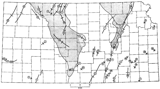
Smaller Structures--In addition to the large structures mentioned, many smaller ones occur in the state, some of which have economic importance for their role in trapping petroleum. Locations of some of these features are shown in Figure 101.
Figure 101--Some minor structures in Kansas. 1, Abilene Anticline; 2, Agra Anticline; 3, Aldrich Anticline; 4, Alma-Davis Ranch Anticline; 5, Beaumont Anticline; 6, Bluff City-Valley Center-Elbing Anticline; 7, Brownville Syncline; 8, Burns Dome; 9, Chesney Dome; 10, Coats Anticline; 11, Coffeyville Dome; 12, Crooked Creek Fault; 13, Cunningham Anticline; 14, Densmore Anticline; 15, Dexter-Otto Anticline; 16, Ellsworth Anticline; 17, Elmdale Dome; 18, Fairport Anticline; 19 Fowler Fault; 20, Fredonia Dome; 21, Greenwich Anticline; 22, Goodland Anticline; 23, Halstead-Graber Anticline; 24, Jennings Anticline; 25, Kismet High; 26, Linda Anticline; 27, Long Island Syncline; 28, Longton Anticline; 29, McLouth Dome; 30, Mildred Dome; 31, Morris Anticline; 32, Mound City Dome; 33, Oil Hill Dome; 34, Phillipsburg Syncline; 35, Rainbow-Graham Anticline; 36, Redbud Dome; 37, Rose Dome; 38, Rush Rib; 39, Selden Syncline; 40, Silver City Dome; 41, Straham Anticline; 42, Stuttgart-Huffstutter Anticline; 43, Syracuse Anticline; 44, Syracuse Fault; 45, Virgil Anticline; 46, Voshell Anticline; 47, Willowdale Anticline; 48, Winfield Anticline; 49, Woodston Anticline (modified from Jewett and Merriam, 1959). An Acrobat PDF version of this figure is available.
Prev Page--Major Unconformities || Next Page--Present Structure
Kansas Geological Survey, Geologic History of Kansas
Comments to webadmin@kgs.ku.edu
Web version April 2006. Original publication date Dec. 1963.
URL=http://www.kgs.ku.edu/Publications/Bulletins/162/05_tect.html