![]()
Prev Page--Contents || Next Page--Stratigraphy--Cenozoic
Abstract
Kansas, part of the stable interior, has a cover of sedimentary rocks, nowhere more than about 9,500 feet thick, which is thin when compared to the section in basinal areas on the craton. When viewed in proper perspective, the relatively simple succession of thin sedimentary strata, perhaps representing only 15 to 50 percent of post-Precambrian time, appears as a veneer covering the Precambrian basement complex.
Beds of Quaternary age, consisting of unconsolidated sand, gravel, silt, and clay, are confined mostly to present drainage systems and are relatively thin; Pleistocene glacial deposits cover much of northeastern Kansas. Nonmarine Tertiary (Pliocene) rocks, mainly unconsolidated gravel, sand, and silt, blanket the western one-third of Kansas, masking the underlying stratigraphy and structure. Rocks of Mesozoic age, predominantly thick accumulations of marine shale, limestone, and chalk, and nonmarine deposits of sandstone and shale, cover the western one-half of Kansas and increase in thickness westward. Basal units of the Mesozoic sequence overstep Paleozoic beds with a pronounced unconformity.
Rocks of Pennsylvanian and Permian age, characterized by cycles of marine and nonmarine strata, occur statewide. Thin but persistent units can be traced over large areas of the Midcontinent region. Lateral facies changes occur between the shallow shelflike areas and the deeper basins. Channel sandstones mark many of the disconformities, which are numerous owing to the cyclical deposition. There are rocks representing all pre-Pennsylvanian systems, consisting mainly of marine sediments--limestone and dolomite and some shale and sandstone. The thickest sections of pre-Pennsylvanian rocks are found near the centers of basins, where they have been protected from extensive erosion. Unconformities separate all rock systems.
Five peridotitic intrusive igneous plugs crop out in Riley County, and one peridotitic and one granitic outcrop are known in Woodson County. One of the plugs has been dated as early Tertiary.
The Precambrian basement complex consists mainly of granite, quartzite, and schist. Distribution of sediments, mafic igneous rocks, extrusives, granodiorite, syenite, and granite, however, is at best only vaguely known. A weathered or detrital material known as "granite wash" covers large areas beneath Paleozoic sediments at this major unconformity.
Two major structural units and parts of seven others are present in Kansas. Four of these are uparched areas that separate larger downwarped basins and serve to delimit them. These major pre-Desmoinesian post-Mississippian structures, almost unchanged since their formation, outline the petroliferous provinces of Kansas.
Only the southwestern part of the Forest City Basin extends into Kansas. It is bounded on the west by the Nemaha Anticline and on the southwest by the low, indistinct, northwest-trending Bourbon Arch. The basinal axis trends slightly east of north and lies close to and parallel to the Nemaha; hence, the basin has an asymmetrical profile and a steep west flank. The present basin, formerly part of the older North Kansas Basin, became a separate feature after Mississippian time. South of the Bourbon Arch in southeastern Kansas is the Cherokee Basin, which developed on the older Chautauqua Arch. The basinal axis lies near and parallel to the Nemaha Anticline, making the basin asymmetrical.
The long, narrow Nemaha Anticline trends northeastward across Kansas, separating the Forest City and Cherokee Basins on the east from the Salina and Sedgwick Basins on the west. The Precambrian core of the Nemaha, within about 600 feet of the surface near the Nebraska border and 4,000 feet at the Oklahoma border, is characterized by a series of local knobs along its crest. Pre-Pennsylvanian strata have been upturned, truncated, and overstepped on both sides at the north end, but farther south the Paleozoic beds are folded over the crest. The anticline is faulted along the east side in several areas, and earthquakes indicate that movement is continuing.
The northern part of the Salina Basin extends into Nebraska from Kansas; the axis of this second largest basin in Kansas trends northwestward. The Sedgwick Basin, a shelflike extension of the Anadarko Basin of Oklahoma, is roughly symmetrical and plunges southward. Strata are characterized by facies change and thicken southward.
The Central Kansas Uplift (and associated minor structures) is the structural backbone of Kansas and separates the Salina Basin on the east from the Hugoton Embayment on the west. On its higher parts, Precambrian rocks are overlain by rocks as young as Pennsylvanian, and on the flanks pre-Pennsylvanian units are upturned, truncated, and overstepped. To the northwest and on the same trend as the Central Kansas Uplift is the Cambridge Arch (and subsidiary features). This arch, the Central Kansas Uplift, and the Chadron Arch of Nebraska, form an arcuate chain of features convex to the southwest. The Pratt Anticline, a large, broad, southward-plunging nose of the Central Kansas Uplift, dies out southward in Oklahoma. On parts of its crest Mississippian rocks are absent and Pennsylvanian beds overlie Viola Limestone and older formations.
The Hugoton Embayment, a northern shelflike extension of the larger Anadarko Basin of Oklahoma, extends over parts of four states, including one-third of Kansas. The embayment plunges southward and sediments thicken both toward the axis and southward into the Anadarko Basin.
Present structure of Kansas is shown and contrasted by maps on top of the Ogallala (Pliocene), Dakota (Cretaceous), Stone Corral (Permian), Lansing (Pennsylvanian), Mississippian, "Hunton" (Silurian-Devonian), Arbuckle (Cambrian-Ordovician), and Precambrian rocks. Many shallow beds in the Paleozoic succession accurately reflect deeper structure, but because of effects of solution and other modifying conditions, others do not.
Patterns of deformation in Kansas have changed through geologic history; although some areas have always been structurally positive and others always negative, some have been reversed. Incompleteness of the rock record impedes interpretation of events, but stratigraphic studies show that at least since Precambrian time, Kansas has been in a tectonic setting similar to that of the present. By study of a series of isopachous maps it is possible to systematize the pulsating up-and-down movements of the crust and to recognize past patterns of deformation.
Small folds and faults exhibit cross trends at approximately N 12° E, N 40° E, and N 42° W. Structural closure ranges from near nothing to several hundred feet and may change in magnitude and position with depth. Some deep structures are represented at the surface by mere nosing; conversely, many surface structures die out at depth. Structural shapes range from domes to sharp, elongated anticlines.
Small structures, commonly known as plains-type folds, are characterized by uplift with no adjoining depression, thinning of beds over the crest (or increased magnitude with depth), asymmetry, and association with normal faulting; Many explanations have been offered for the origin of these structures, according to the presumed major factor in forming them: (1) tangential compression, (2) torsional stress, (3) differential settling of sediments, and (4) local vertical uplift. Probably all four are important, and each may partly explain a given structure. The present structural pattern in Kansas is believed to be the result of vertical relief of stresses transmitted through the rigid crystalline basement. It is reasonable to assume that anticlinal structures developed as local areas remained high during regional subsidence. Zones or lines of weakness, along which adjustment has developed plains-type folds, are thought to be inherited from Precambrian orogenic movements.
Introduction
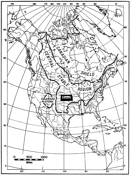
Kansas, located in the heart of the United States on a buried southern extension of the Canadian Shield, which is part of the continental nucleus, is ideally situated for a study of the stable interior of North America (Fig. 1). Sedimentary rocks of the region are those typical of a shallow-shelf environment, structure is gentle--in fact, so gentle that it is sometimes difficult to find--and the land is stable. Nothing in the geologic makeup is dramatic or spectacular; simplicity is the usual, rather than the unusual. The neatly arranged geology of Kansas has been described as monotonous, and perhaps rightly so, by those interested in the bizarre. Geology of the Interior Lowlands has been termed the "science of gently-dipping strata" by King (1959).
Figure 1--Index map of North America showing Kansas in relation to Canadian Shield and Central Stable Region (adapted from Eardley, 1951). Kansas occupies a key position intermediate to cratonic shield area, north and east, and mobile belts, south and west.
Kansas is in a critical position to supply information concerning correlations of the stratigraphy between surface outcrop areas in western Missouri; Nebraska and the Dakotas; the Rocky Mountain area including Wyoming, Colorado, and New Mexico; and Oklahoma. It is part of a vast area in Mid-America, known as the Great Plains, stretching from the Canadian border on the north to the Rio Grande on the south, and from the Rocky Mountains on the west to the Central Lowlands on the east. It is for the most part blanketed by unconsolidated deposits of Tertiary and Quaternary age that mask the stratigraphy and structure of older beds. The shape and mode of formation of the various geologic units, especially older ones in the area, are of utmost importance in determining geologic history of the Great Plains, as well as in locating buried deposits of mineral wealth.
Within the last decade accelerated test drilling for oil and gas and for ground water in the central part of the Great Plains, in Kansas in particular, has added much new information on the geology of rocks concealed beneath the mantle of younger, unconsolidated deposits. Sufficient control now is available to permit tracing of stratigraphic units and to allow reasonably accurate portrayal of regional structure. This information, in the form of electric and radioactivity logs and well samples, was utilized in preparing this report.
The objectives of this study were multiple. First, and perhaps most important, was the desirability of better understanding the geologic history of Kansas. With an appreciation of the geologic history of Kansas, special problems could then be investigated. Second, it was obvious that stratigraphic units on the surface in eastern and central Kansas should be traced into the subsurface in order to determine which units are present westward. Because only Tertiary, Mesozoic, and upper Paleozoic rocks crop out in Kansas, emphasis was placed on their stratigraphic relations, both at the surface and in the subsurface, and on their regional correlations into adjacent areas. As a result, lower Paleozoic units were, unfortunately, neglected; however, through the work of others considerable data are available regarding them. Special units were selected for study to serve as examples of types of sediments occurring in a stable-shelf environment. Third, it was hoped that some contribution toward the understanding of plains-type folding could be made, based on information accumulated in the last two decades. Plains-type folds are structurally unique in an otherwise almost featureless expanse. The key to the problem, the Precambrian basement complex, is elusive, and much work needs to be done on the predictability of various aspects of these most interesting structures (Merriam, 1961).
The scope of this endeavor is broad. Although much remains to be done, it is hoped that some aims of the project have been met and that with information assembled here other problems can be investigated advantageously. Work on the project began in the fall of 1953 and with only minor interruptions has continued until the present. Because of the nature of the project it was decided that information would be released as it became available. Accordingly, the first publication appeared in 1954 and others followed. A considerable amount of early work, therefore, had to be brought up to date for inclusion here. Most of the published material is included here for completeness and clarity, and credits are made where appropriate. The amount of material available for study--approximately 130,000 drillers logs, 35,000 electric and radioactivity logs, and 10,000 sample logs--required help to collect, compute, and plot in order to bring the project to the present stage of completion. The help, much of it voluntary, is most appreciated and is recognized in the acknowledgments. Although it is not always possible to acknowledge all work, it is hoped that no major omissions have been made; the bibliography is extensive but by no means complete.
Acknowledgments--The study was accomplished under the direction and inspiration of Dr. Raymond C. Moore, whose guidance and counsel is more than appreciated. Dr. Louis F. Dellwig, Dr. Carlile S. Smith, and Dr. H. A. Ireland graciously gave time and effort in helping me with various problems. Dr. M. L. Thompson and Dr. Walter L. Youngquist kindly read parts of the preliminary manuscript. The opportunity to work on the problem was most generously made possible by Dr. John C. Frye.
The project has been supported in its entirety by the Kansas Geological Survey. I am grateful to Dr. Frank C. Foley, State Geologist and Director, who has granted many special privileges and offered many helpful suggestions to speed completion of this work. I especially thank Dr. William W. Hambleton for his many years of encouragement and assistance when most needed. To Mr. Wallace Lee, I am most grateful for acquainting me with Kansas' subsurface and its many problems. Several of my co-workers, including Mr. Paul C. Franks, Dr. Floyd W. Preston, and especially Mr. Edwin D. Goebel, deserve special mention for long hours of discussion with me concerning many geological problems and their solution. My admiration goes to Dr. Ralph H. King, for his patience in editing the entire manuscript. His knowledge of many subjects has been helpful. To Mrs. Polly Smith Boley I extend thanks for checking information and helping to assemble data for final manuscript compilation. She processed and assembled many of the data for later stages in the project, especially material on the Precambrian.
I also thank many petroleum and service companies and geologists working in Kansas for assistance in collecting information that otherwise could not have been obtained; Messrs. Virgil B. Cole, Robert H. Glover, Wendell S. Johns, Roy P. Lehman, Harvel E. White, and Dr. Robert F. Walters have helped in many ways.
Many former students at The University of Kansas have helped the project immeasurably by assembling, computing, and plotting data and by contributing and developing ideas. Their contribution has been considerable, and I hereby gratefully acknowledge the assistance of each: Messrs. N. Sam Ashley, William R. Atkinson, James K. Hays, Sidney N. Hockens, Tim E. Kelly, Richard H. Lefebvre, Robert L. Mehl, Robert W. Parkhurst, Richard L. Schuman, Robert G. Walton, Richard L. Winchell, Rodger White, and Dr. C. John Mann.
Dr. L. B. Ronca kindly provided the Italian abstract; the drafting was supervised by Mr. Ronald Obenchain; the manuscript was typed by Mrs. Carol Roper and Mrs. Lila Watkins; Mrs. Roberta L. Gerhard and Miss Sally S. Liggett helped prepare copy for publication.
Prev Page--Contents || Next Page--Stratigraphy--Cenozoic
Kansas Geological Survey, Geologic History of Kansas
Comments to webadmin@kgs.ku.edu
Web version April 2006. Original publication date Dec. 1963.
URL=http://www.kgs.ku.edu/Publications/Bulletins/162/02_abstract.html