![]()
Prev Page--Development of Present Structure || Next Page--References
Structural Patterns
In considering size of structural elements and their relation in space, it is convenient to classify them. The largest structural elements of the earth's crust are the continents and ocean basins, which are of first-order magnitude. Subcontinental regions constituting structural entities, such as the Midcontinent, Rocky Mountains, and Colorado Plateau, may be classified as second-order structures. Regional structures, such as the Central Kansas Uplift, Salina Basin, and Nemaha Anticline, are third order; small structures, such as the Stuttgart-Huffstutter Anticline, Long Island Syncline, and Alma Anticline, then, are fourth order. Local closed "highs" are the smallest or fifth-order structures. This classification is useful in that it brings together, for comparison, structures of the same magnitude. It is the small structures and their relations to larger elements that are of concern here.
Locations of the small structures (fourth order) in relation to the major structural features (third order) are shown in Figure 126. Insofar as possible, a random selection of structures was made in order to obtain representative ones in different structural regions, but unfortunately only along oil-producing anticlines is detailed information for structural studies available. It is not possible to obtain sufficient data in synclines or along barren anticlines. All structures studied in detail are shown in Figures 126, 127, 128, 129, 130, 131, 132, 133, 134, 135, and 136, and information from them is listed in Table 7.
Figure 126--Index map of Kansas showing relation of anticlines used in this study (Fig. 126-136) to major pre-Desmoinesian post-Mississippian structures. Structure is shown for A, Hickman; B, Grover; C, Moore; and D, Brock fields (adapted from Merriam, 1955e).
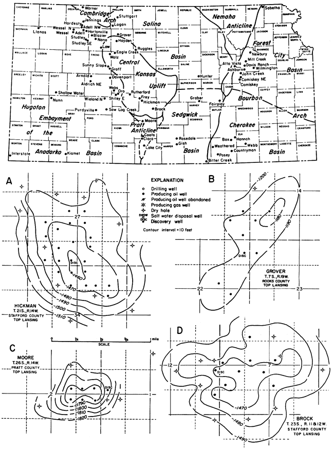
The fields were contoured on top of Lansing, Mississippian, "Hunton," or Viola rocks, at 10-foot intervals. Of course, the figures given in Table 7 are only representative of magnitude because not all fields are completely exploited. More or less closure might be shown if older or younger datum horizons were used for contouring.
Major pre-Desmoinesian post-Mississippian structural elements exhibit two sets of trends--one approximately northeast (N 20° E), as shown by the Nemaha Anticline, and the other northwesterly (N 45° W), exemplified by the Central Kansas Uplift. Smaller structures superimposed on these uplifts or adjacent to them are either parallel (subparallel) or perpendicular to the larger structures. About 8 percent of the structures studied are domes and thus show no preferential trend.
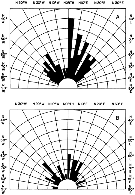
Fifth-order structures likewise exhibit cross trends, but a study of these structures reveals three sets of trends at approximately N 12° E, N 40° E, and N 42° W (Fig. 137). The faults in Kansas also reveal much the same pattern, although northeast-trending ones seemingly are not so plentiful.
Table 7--Data on some oil- and gas-producing anticlinal and domal structures in Kansas. 1As measured by planimetry on scale of 4 inches=1 mile. To convert square inches to sqaure miles, multiply by 24.89x10⁻¹¹.
| Field | Structural feature |
Contour mapping horizon |
Depth to mapping horizon in discovery well, feet |
Direction of axis |
Amount of closure, feet |
Area of closure, square inches1 |
Length/ width ratio |
|---|---|---|---|---|---|---|---|
| Nunn | Hugoton | Lansing | 3905 | N 25° E | 13 | 17.5 | 2.6 |
| Law | Central Kansas Uplift | Lansing | 3741 | N 26° W | 16 | 13.7 | 2.7 |
| Shallow Water | Hugoton | Lansing | 3940 | N 32° W | 28 | 16.0 | 2.8 |
| Hardesty | Cambridge | Lansing | 3643 | N 38° E | 20 | 9.0 | 1.3 |
| Arnold | Hugoton | Lansing | 3945 | N 58° W | 11 | 5.0 | 2.0 |
| Nana | Cambridge | Lansing | 3581 | N 33° W | 33 | 9.0 | 2.0 |
| Clara | Pratt | Lansing | 3949 | N 30° E | 36 | 7.0 | 2.1 |
| Ruggles | Salina | Lansing | 3019 | N 33° W | 20 | 8.0 | 1.6 |
| Frey | Central Kansas Uplift | Lansing | 3378 | N 30° E | 23 | 11.5 | 3.1 |
| Rutherford | Central Kansas Uplift | Lansing | 3493 | N 20° E | 13 | 9.5 | 2.4 |
| Stuttgart | Cambridge | Lansing | 3128 | N 12° E | 28 | 9.0 | 2.8 |
| Lake City | Pratt | Lansing | 3745 | N 19° E | 28 | 10.3 | 1.7 |
| Hayden | Central Kansas Uplift | Lansing | 3267 | N 54° W | 20 | 7.5 | 1.8 |
| Logan | Cambridge | Lansing | 3083 | N 26° W | 17 | 10.5 | 1.5 |
| Hickman | Central Kansas Uplift | Lansing | 3402 | N 42° W | 20 | 14.2 | 1.5 |
| Grover | Salina | Lansing | 3126 | N 34° E | 15 | 8.4 | 2.7 |
| Moore | Pratt | Lansing | 3778 | dome | 39 | 4.5 | 1.0 |
| Brock | Central Kansas Uplift | Lansing | 3307 | N 39° E | 27 | 12.6 | 1.2 |
| Adell | Cambridge | Lansing | 3630 | N 53° W | 61 | 17.6 | 2.3 |
| Oro | Hugoton | Lansing | 3723 | dome | 33 | 5.7 | 1.0 |
| Groff | Central Kansas Uplift | Lansing | 3416 | N 20° W | 22 | 11.2 | 2.2 |
| Warner | Cambridge | Lansing | 3147 | N 34° E | 29 | 10.2 | 2.7 |
| Webs | Hugoton | Lansing | 3732 | dome | 23 | 3.9 | 1.0 |
| Sunny Slope | Central Kansas Uplift | Lansing | 3451 | N 60° W | 12 | 8.0 | 2.2 |
| Sawlog Creek | Hugoton | Lansing | 3910 | N 37° W | 22 | 6.3 | 1.8 |
| Walz | Central Kansas Uplift | Lansing | 3371 | N 36° E | 20 | 7.1 | 1.8 |
| Studley | Hugoton | Lansing | 3687 | N 53° W | 26 | 15.0 | 3.0 |
| Adell NW | Cambridge | Lansing | 3633 | N 3° W | 49 | 10.8 | 1.5 |
| Wessel | Hugoton | Lansing | 3944 | N 3° W | 14 | 6.8 | 1.7 |
| Llanos | Hugoton | Lansing | 4290 | N 13° E | 26 | 10.8 | 2.2 |
| Purdyville | Hugoton | Lansing | 4010 | N 25° W | 31 | 6.2 | 1.8 |
| Hortonville | Cambridge | Lansing | 3736 | N 45° W | 16 | 3.0 | 1.2 |
| Coats | Pratt | Lansing | 3920 | dome | 104 | 9.0 | 1.0 |
| Jennings | Cambridge | Lansing | 3403 | N - S | 14 | 9.9 | 1.2 |
| Asburn | Forest City | Viola | 3254 | N 13° E | 29 | 8.5 | 2.7 |
| Comiskey | Forest City | Viola | 2929 | N 22° E | 30 | 12.O | 3.0 |
| Sabetha | Forest City | "Hunton" | 2825 | N 46° E | 63 | 6.1 | 1.8 |
| Alta Vista | Nemaha | Cottonwood | N 16° E | 30 | 13.0 | 3.5 | |
| Fairplay | Sedgwick | Mississippian | 2250 | dome | 20 | 10.6 | 1.0 |
| Davenport | Hugoton | Lansing | 3596 | N 75° E | 14 | 7.5 | 1.2 |
| Kismet | Hugoton | Lansing | 4314 | N 15° W | 21 | 15.7 | 3.2 |
| Shiley East | Hugoton | Lansing | 3703 | dome | 34 | 8.7 | 1.0 |
| Blazier | Hugoton | Lansing | 3666 | N 52° W | 34 | 7.2 | 2.5 |
| Aldrich NE | Hugoton | Lansing | 3810 | N 54° E | 40 | 26.7 | 1.4 |
| Eagle Creek | Central Kansas Uplift | Lansing | 3317 | N 46° E | 19 | 5.3 | 1.6 |
| Wieland N | Hugoton | Lansing | 3756 | dome | 56 | 13.1 | 1.0 |
| Gish | Sedgwick | Mississippian | 4318 | N 42° E | 22 | 10.5 | 1.6 |
| Rosedale | Sedgwick | Lansing | 3234 | N 28° W | 18 | 6.3 | 1.7 |
| Interstate | Hugoton | Lansing | 2925 | N 32° E | 38 | 71.2 | 2.6 |
| Graber | Sedgwick | "Hunton" | 3300 | N 9° E | 70 | 63.5 | 3.4 |
| Bitter Creek | Sedgwick | Mississippian | 3498 | N 32° E | 19 | 9.1 | 2.2 |
| Hunter | Salina | Mississippian | 2676 | N 20° E | 32 | 24.9 | 2.5 |
| John Creek | Forest City | Viola | 3088 | N 19° E | 85 | 60.2 | 3.3 |
| Mill Creek | Forest City | Mississippian | 2195 | N 15° E | 20 | 9.4 | 2.2 |
| Davis Ranch | Forest City | Viola | 3199 | N 2° E | 53 | 17.5 | 3.0 |
| Newbury | Forest City | Mississippian | 2156 | N 21° E | 30 | 9.4 | 2.5 |
| Weathered | Cherokee | Mississippian | 3057 | N 14° E | 60 | 12.3 | 2.8 |
| Posey | Cherokee | Mississippian | 3164 | N - S | 24 | 12.0 | 1.7 |
| Box | Cherokee | Mississippian | 2840 | dome | 27 | 5.1 | 1.0 |
| Hannah | Cherokee | Kansas City | 1959 | N 12° W | 23 | 6.8 | 2.0 |
| Countryman | Cherokee | Mississippian | 2825 | N 12° E N 40° E |
37 35 |
8.7 7.0 |
2.3 3.3 |
| Webb | Cherokee | Mississippian | 1931 | N 21° E | 43 | 8.7 | 1.6 |
| Wilmington | Forest City | Viola | 2994 | dome | 20 | 5.3 | 1.0 |
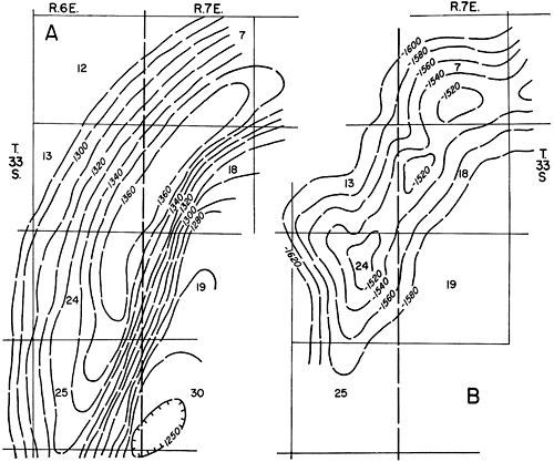
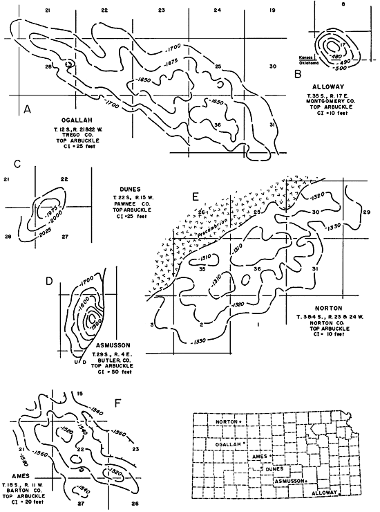
| Ogallah | Central Kansas Uplift | Arbuckle | 3961 | N 64° W | 49 | 62.4 | 3.6 |
| Dunes | Central Kansas Uplift | Arbuckle | 3956 | N 38° E | 47 | 5.4 | 2.4 |
| Alloway | Cherokee | Arbuckle | dome | 35 | 6.2 | 1.0 | |
| Norton | Cambridge | Arbuckle | 3778 | N 52° E | 26 | 57.7 | 3.0 |
| Aldrich NE | Hugoton | Mississippian | 4398 | N 50° E | 33 | 20.4 | 1.4 |
| Purdyville | Hugoton | Mississippian | 4663 | N 50° E | 42 | 11.9 | 1.9 |
| Graber | Sedgwick | "Hunton" | 3274 | N 12° E | 60 | 51.0 | 3.3 |
| North Star | Central Kansas Uplift | Viola | 4063 | N 10° E | 30 | 8.5 | 2.2 |
| Gish | Sedgwick | Simpson | 4700 | N 40° E | 28 | 9.3 | 1.5 |
| Fall Creek | Sedgwick | Simpson | 4146 | N 34° E | 78 | 13.2 | 1.6 |
| Asmusson | Nemaha | Arbuckle | 2695 | N 13° E | 272 | 10.7 | 2.4 |
| Ames | Central Kansas Uplift | Arbuckle | 3348 | N 53° W | 31 | 15.6 | 2.9 |
Figure 127--Structure of A, Adell; B, Oro; C, Warner; D, Groff; E, Webs; F, Sunny Slope; G, Saw Log Creek; and H, Walz fields (adapted from Merriam, 1955e).
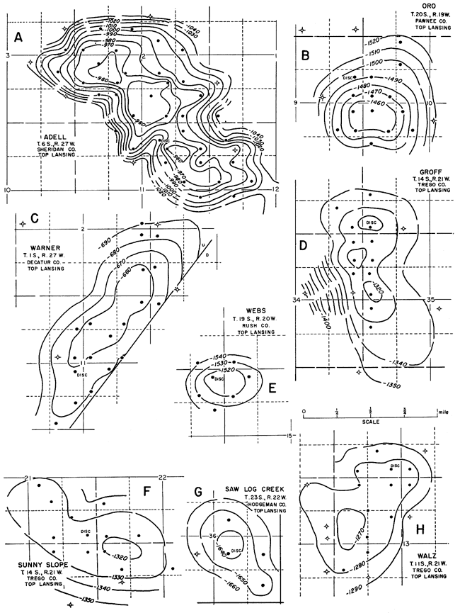
Figure 128--Structure of A, Studley and Studley Southeast; B, Adell Northwest; C, Wessel and Wessel North; D, Llanos; E, Purdyville; F, Hortonville; G, Coats; and H, Jennings fields (adapted from Merriam, 1955e).
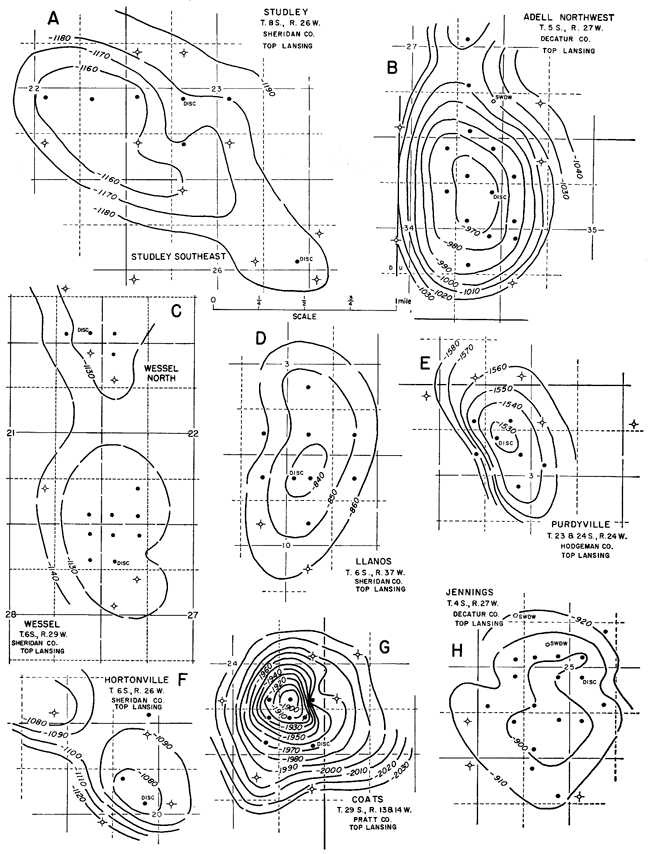
Figure 129--Structure of A, Nana; B, Clara; C, Ruggels; D, Frey; E, Rutherford; F, Stuttgart; G, Lake City; H, Hayden; and I, Logan fields (adapted from Merriam, 1955e).
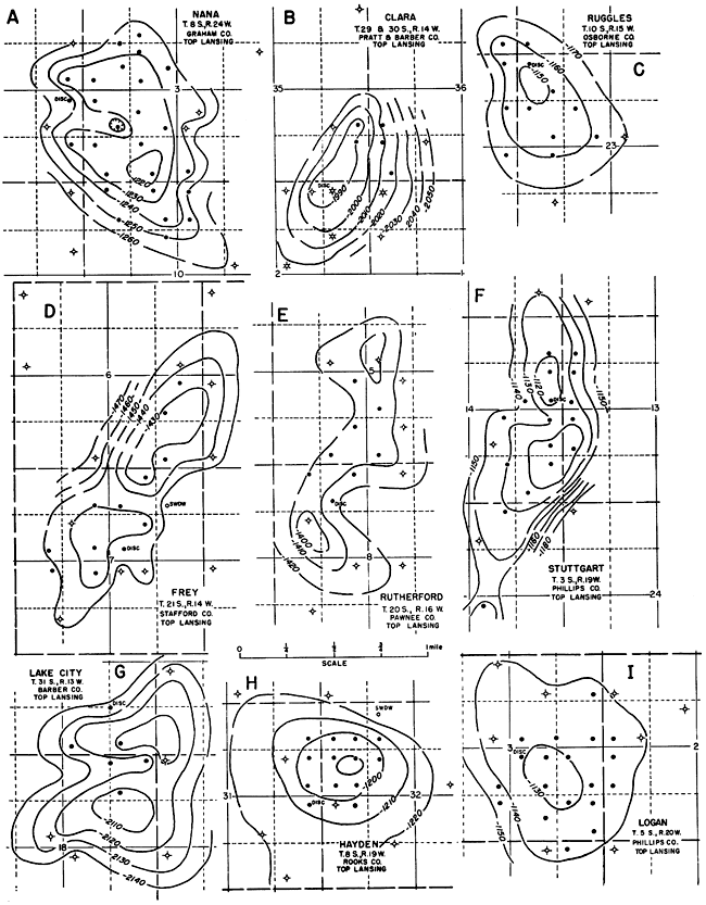
Figure 130--Structure of A, Nunn; B, Arnold; C, Hardesty; D, Law; and E, Shallow Water fields (adapted from Merriam, 1955e).
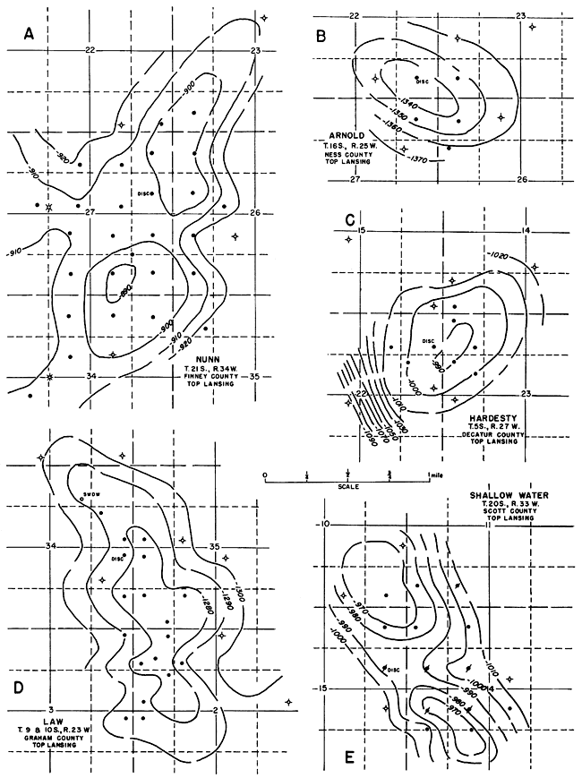
Figure 131--Structure of A, Davenport; B, Kismet; C, Shiley East; D, Aldrich Northeast; E, Blazier; and F, Eagle Creek fields.
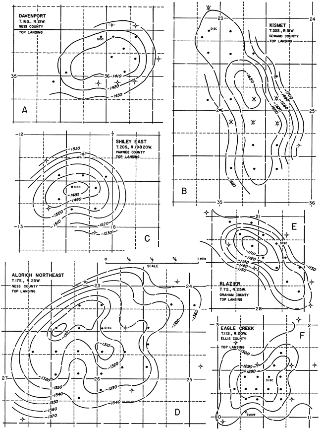
Figure 132--Structure of A, Wieland North; B, Gish; C, Rosedale; and D, Interstate fields.
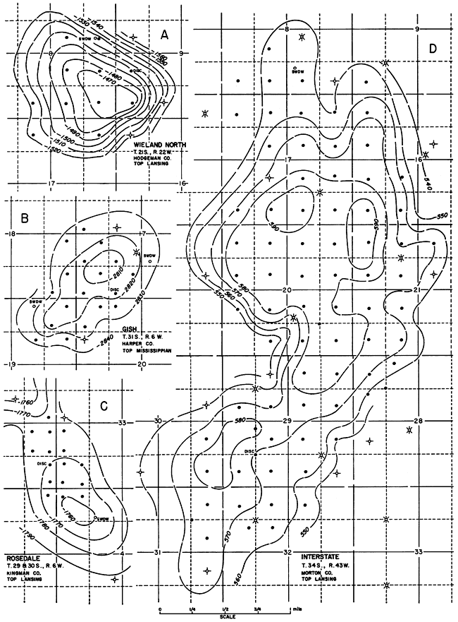
Figure 133--Structure of A, Graber; B, Bitter Creek; and C, Hunter fields.
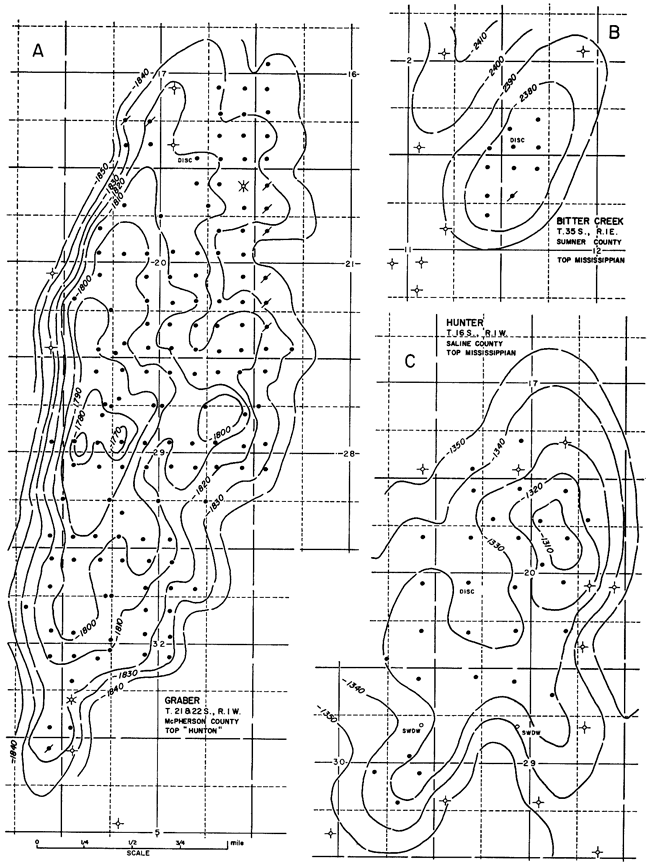
Figure 134--Structure of A, Wilmington; B, John Creek; C, Mill Creek; D, Newbury; and E, Davis Ranch fields.
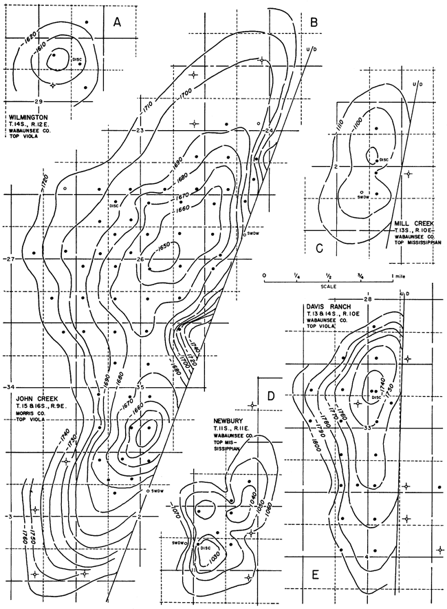
Figure 135--Structure of A, Ashburn; B, Comisky and Comisky Northeast; C, Alta Vista; D, Sabetha; and E, Fairplay fields.
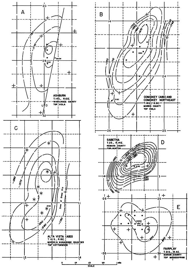
Figure 136--Structure of A, Weathered; B, Posey; C, Box; D, Hannah; E, Countryman; and F, Webb fields.
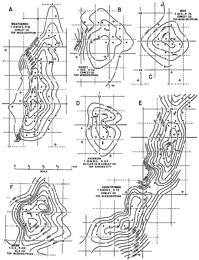
Figure 137--Direction of A, structural axes, and B, fault trends. Three sets of structural trends approximately N 12° E, and N 42° W are evident.
Magnitude of Features
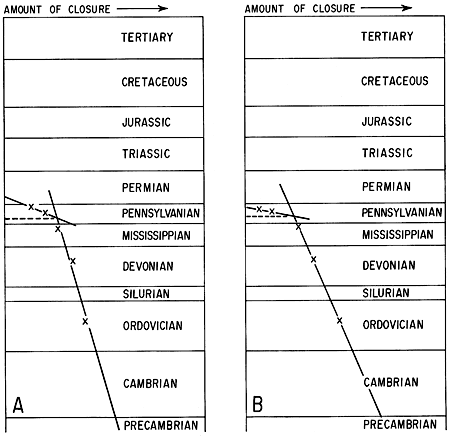
The amount of closure ranges from 11 feet at Arnold (Fig. 130) to 104 feet at Coats (Fig. 128). Average closure of the fields contoured is 27 feet on the Lansing, 30 feet on the Mississippian, and 43 feet on the Viola. Because only two fields were contoured on the "Hunton," the average closure is not significant. In general, it may be stated that the amount of closure increases with depth. Merriam (1955c) found that in eight of ten fields in central and western Kansas the structural relief on the Stone Corral is less than on the Lansing. Many areas in southeastern Kansas show a well-defined relationship between surface structure and structure at depth (Merriam and Goebel, 1959c). This is not a new idea; it was pointed out 34 years ago by Bass (1929) and 39 years ago by Ley (1924). In many places, surface structure in Pennsylvanian or Permian beds may provide clues to the attitude of the Mississippian or older surfaces; however, in other fields there is no coincidence.
Because structural relief in surface rocks is small, anticlines at depth are not all indicated by closure at the surface. Many northeast-trending anticlines as mapped on top of Mississippian rocks are revealed on the surface by southwest-plunging structural noses.
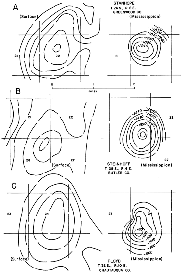
Three areas of surface closure and their corresponding subsurface structures are shown in Figure 138. Structure in outcropping rocks is revealed as northeast-trending anticlines with the structural saddle located on the southeast, which regionally is updip. Beneath these areas of low closure, 10 to 30 feet, are more pronounced structures on the Mississippian surface that exhibit at least 40 feet of closure.
Figure 138--Three anticlinal area in southeastern Kansas showing relation of configuration of structure in surface beds to top of Mississippian rocks: A, Stanhope field; B, Steinhoff field; and C, Floyd field.
The position of the structural axis also may shift with depth. According to Ley (1924, p. 449):
Folding generally shifts with depth, sometimes to the west-southwest as in the Red Bank pool at Coffeyville in Montgomery County, or to the south, as in the Rose dome area of southern Woodson County. There seems to be no hard and fast rule which can be applied; better practice would be to apply the direction of shifting which subsurface studies establish for the area in question.
Part of this shift in position with depth may be due to westerly regional dip and part to convergence of the two mapped horizons. Other factors also may influence the shift.
Virgil Anticline--Beekly (1929) has shown the relation of surface structure to structure on top of the Mississippian in the Virgil Anticline in Greenwood County (Fig. 139). Concerning this structure he wrote (1929, p. 145):
The Virgil pool is located on a surface structure having more than 60 feet of closure. . . the surface structure [is] mapped on the top of the LeCompton limestone and on intervals between this datum bed and the Deer Creek and Topeka limestones. . . . The subsurface structure . . . is contoured on the top of the "Mississippi lime." Although not recognized as a satisfactory marker in many localities in Kansas, it was used in this field for the reasons that it happens to conform very closely with the surface structure. " . available well logs show such remarkable regularity of section and intervals that the subsurface structure as mapped on the top of the "Mississippi" cannot differ in any essential respect from that of any higher bed or that mapped at the surface.
Figure 139--Virgil Anticline. A, Structural map contoured at 20-foot intervals on top of Lecompton Limestone; B, structural map contoured at 20-foot intervals on top of "Mississippi lime." Both maps from Beekly (1929).
The Mississippian structural map (Fig. 139B) shows approximately 100 feet of closure, and there is negligible offset of the structural axis at greater depth.
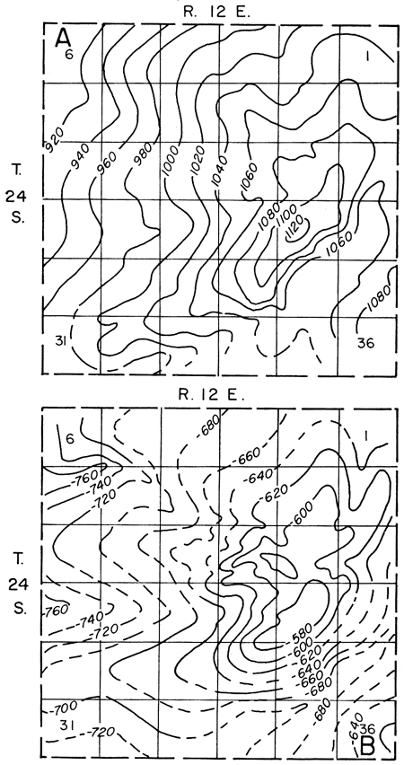
Reese Anticline--The Reese Anticline is a long, narrow, northeast-trending feature located in Greenwood County (Fig. 140). Structure on top of the Mississippian reveals a northeast-trending, double-plunging anticline having 100 to 120 feet of closure. Control available suggests that the anticline is slightly asymmetrical, the northwest flank being steeper.
Figure 140--Reese Anticline. A, Structural map contoured at 10-foot? intervals on outcropping rocks (from Kansas Blue Print Company, Wichita); B, structural map contoured at 20-foot intervals on top of Mississippian rocks (from Merriam and Goebel, 1959c).
The surface structure (Fig. 140A) was taken from a map supplied by the Kansas Blue Print Co. of Wichita. The contour interval is not known, but it seems to be 10 feet. The Reese Anticline as outlined by surface structure is mainly a southwest-plunging nose; small areas of closure are located along the crest. Maximum closure of these areas seems to be about 20 feet. Although the surface and subsurface areas of closure do not coincide, the position and trend of the axis are the same on both maps.
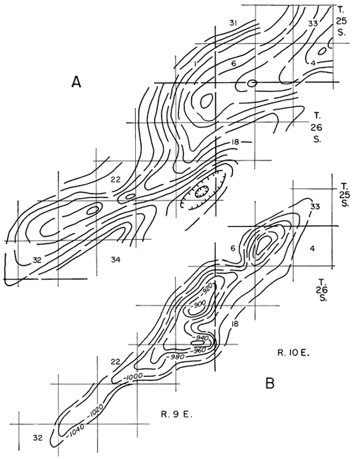
Countryman Anticline--The Countryman Anticline is a northerly trending feature located in Cowley County (Fig. 141). The surface structure (Fig. l41A) was taken from a Federal Geological Survey open-file report. Some subsurface control is available along the crest, but is inadequate to delineate the structure in the subsurface.
Figure 141--Countryman Anticline. A, Surface structural map showing northeast trend of Countryman (from Bass, 1929); B, structure on Mississippian rocks closely resembles surface structure, although local closures along crest of structure do not coincide (from Merriam and Goebel, 1959c).
Structure on top of the Mississippian reveals three areas of closure on the crest of the Countryman. The maximum local closure is 30 to 50 feet, but closure for the entire structure is probably somewhat larger. Because well control is sparse on the flanks, it is not possible to determine symmetrical expression of structure.
The surface trend is closely coincident with the trend on top of the Mississippian; however, maximum closure is less at the surface. Seemingly only about 20 feet of closure is evident in outcropping beds. If either flank is steeper, it is the southeast one.
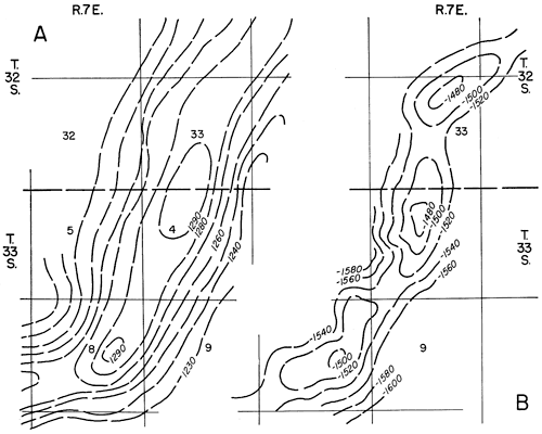
Dexter Anticline--The Dexter Anticline is located in Cowley County just southwest of the Countryman Anticline and on the same general structural trend (Fig. 142). Few wells have been drilled to the Mississippian, but enough control is available to give a reasonably accurate picture of the general nature of the structure. The surface map reproduced here is from Bass (1929).
Figure 142--Dexter Anticline. A, Structural map contoured at 10-foot intervals on outcropping beds (from Bass, 1929); B, subsurface structural map contoured at 20-foot intervals on top of Mississippian rocks (from Merriam and Goebel, 1959c).
Structure on top of the Mississippian is a north- to northeast-trending anticline showing three local areas having 20 to 40 feet of closure; the overall closure of the structure is probably greater. Lack of well control on the flanks makes it difficult to judge the symmetry of the structure, but it seems to be slightly steeper on the southeast side.
Surface structure (Fig. 142A) reveals only one large area of closure of about 20 feet. The position of the crest of the surface structure corresponds well to the position of the crest on the Mississippian. Both maps indicate that the structure continues to the northeast and to the south.
The four cited examples showing relation of surface to subsurface structure in southeastern Kansas are unfortunately all along the same structural trend. The structural relief along this trend and other parallel elements (Longton Ridge and Winfield Anticline) is greater than in intervening areas; therefore, structural relations may be different in these intervening areas because of the lesser magnitude of structure.
From limited information, then, the following generalizations can be made, but they may not hold true for all of Kansas (Merriam and Goebel, 1959c): (1) Structural relief seems to increase with depth (Fig. 143). Structural noses in surface rocks may reveal the presence of closed anticlinal structures in older beds; if closure is evident at the surface, it should increase downward. Many surface structures do not persist at depth, however. It may perhaps be safely assumed that the sharper and more pronounced features will carry down. (2) Crests of structure shift with depth. In general, the greater the depth to the top of the Mississippian, the greater the shift; commonly the shift is westward. (3) In general the southeast flank of northeast-trending structures has steeper dip than the northwest flank. McCoy and Keyte (1934, p. 300) found a steep east flank on the Beaumont. Anticline and postulated that it was faulted.
Figure 143--Chart showing increase of structural closure with depth for A, Mill Creek, and B, Ashburn, fields in Wabaunsee County. Preliminary studies indicate that amount of closure (or area under closure, or cumulative of either) plotted against age (or depth) of contoured horizon may reveal interesting information regarding development of structure. An abrupt change in slope of line should indicate time of structural. deformation. In addition, amount of closure at depth should be predictable knowing that of shallower horizons.
Shape of Structures
Structural shapes range from domes to sharp elongated anticlines. Examples of domes are Moore (Fig. 126) and Oro (Fig. 127). Examples of anticlines are many, but those having a length/width ratio greater than 3 include: Frey (Fig. 129) and Studley (Fig. 128). Some fields, such as Countryman (Fig. 136) and Aldrich Northeast {Fig. 131), have multiple areas of closure. Some structures have one steeper flank, giving them an asymmetrical aspect, such as Adell (Fig. 127) and Groff (Fig. 127). Many of the fields having steep flanks show faulting in the lower beds, indicating that the steep dip is the result of draping over a fault block. Some fields, such as Davis Ranch (Fig. 134) and John Creek (Fig. 134), are known to be faulted at the level of contouring, and therefore the fault traces are shown. Lack of information makes it difficult to determine the precise direction and magnitude of faults.
The area under closure differs considerably among the structures studied. Hortonville has the least closure, only 0.2 square mile (Fig. 128). The largest structure is Interstate (Fig. 132), which has about 4.5 square miles of closure; other large structures include Graber (Fig. 133) and John Creek (Fig. 134).
Structures contoured on top of Arbuckle rocks are shown in Figure 144. The shapes and sizes of these structures are as varied as those shown on younger horizons (Table 7). The structure on top of Arbuckle rocks in the Norton field is similar to that on the higher horizons (Merriam and Goebel, 1954). The Norton feature is an elongated, northeast-trending anticline of low relief with the southeast flank steeper than the northwest. The anticline plunges both northeastward and southwestward about 20 feet per mile. The structure is irregular and has four small areas of closure, the maximum being about 10 feet. Minor irregularities of the structure are believed to be the result of erosion. Because the Arbuckle is absent on the northwest flank, it is not possible to determine the original extent of the structure. On the Central Kansas Uplift many of the structures are large, broad, anastomosing features that are difficult to delineate. In other areas, structures at the horizon of the Arbuckle are sharp and many, such as Asmusson (Fig. 144), may be faulted.
Figure 144--Structure of Ogallah, Alloway, Dunes, Asmusson, North, and Ames fields (in part from Merriam and Goebel, 1954; Merriam and Smith, 1962).
It has been noted from this study that small anticlines in Kansas can be classified into two types, depending on the location of the structural saddle, or spill point, on the structure. In one type, the spill point is on the side that is updip regionally, and normally that side is the critical flank. Two examples of this side-opening type are shown in Figure 145. In the Willowdale structure (Fig. 145A) the regional dip on the Viola is to the southeast, and the structure is elongate parallel to the regional strike. In shallower beds, this type of structure would be represented by a southeastward-plunging nose. Levorsen (1927) has shown the effect of convergence on the closure of structure and the shift of structural axes with depth. He demonstrated how a structural nose on surface beds becomes a closed anticline on a deeper horizon because the two horizons converge Updip regionally. These principles apply here. The Wakeeney structure (Fig. 145B) is mapped on the Stone Corral, which has a regional dip to the northwest.
Figure 145--Two types of anticlinal structures. A and B have a side-opening spill point (Willowdale and Wakeeny fields); C and D have an open-end spill point (Hockett and Buhler fields).
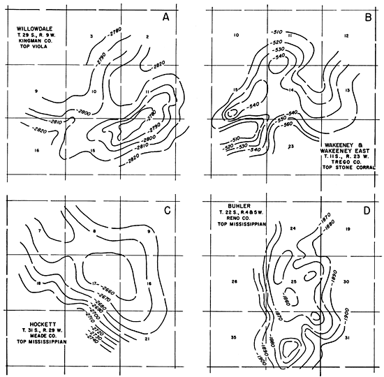
The other type of structure is one in which the structural saddle is located at the end of the feature and which could therefore be termed an open-end type. Most of these are situated along larger elongate structures; in fact, several closed areas may be found on trends, such as the Abilene Anticline, that exhibit an open-end spill point. Examples given here are the Hockett structure (Fig. 145C), which plunges southeastward, and the Buhler structure, which plunges southward (Fig. 145D).
Plains-Type Folding
Although for individual structures neither the type of folding nor the originating force, whether compressional, vertical, or compactionaI, is known, it is significant that local anticlines fit into a regional pattern. This certainly implies some common factor in their origin. Because structures are present in older beds, it is assumed that they are tectonic or are related to tectonic rather than surficial movements. In addition, relation of the structure at one horizon to that at another, as well as the position and arrangement of strata, strongly suggest vertical structural movement-such as upwarping and downwarping combined with differential compaction and draping of beds over fault blocks--rather than horizontal movement. This is so-called "plains-type folding."
Gardner (1917) was perhaps the first to champion vertical uplift in explaining plainstype folding of the Midcontinent area. He reasoned that lateral stresses could not be transmitted through weak sediments for any great distance and therefore could not account for the folds. Because the local structures are small, they must have been produced by pressures that acted mainly vertically. Blackwelder (1920) reviewed the suggested explanations for the formation of Midcontinent structure-tangential compression, vertical readjustment due to deepseated rock flowage, and differential settling of sediments-and concluded that the last of these hypotheses is the most probable.
Fath (1920), in his classic paper on Midcontinent structure, postulated that horizontal forces are transmitted through the rigid crystalline basement. If displacements along faults in the basement were horizontal, the results were tension faults in the surface beds; if displacements were vertical, anticlinal folds developed. Configuration of the resulting structure at the surface would depend on the incompetency (or competency) of the units overlying the basement. Path concluded further that an extensive series of essentially parallel fault zones had to be present in the basement complex to account for the geographic distribution of structure. The complex of faults was the result of orogenesis, which probably took place in Precambrian time, since no deformation of great magnitude is known to have occurred in the Midcontinent in the Paleozoic. Later, intermittent movement along these Precambrian lines of weakness resulted in the present structural features. By his keen insight into the problem, Path was therefore able to demonstrate that the belts of faults in northeastern Oklahoma, the anticlinal folds, and the Nemaha granite ridge were related in origin. He expressed similar ideas in 1921.
McCoy (1921) sought to explain the fault zones in northeastern Oklahoma as the result of tensile stresses developed in a settling basin. Monnett (1922) thought that the magnitude and arrangement of structures could have been produced by differential settling of sediments, and suggested a relation between folding and lithologic composition. Powers (1922) discussed five hypotheses for the origin of Midcontinent structure: (1) tangential compression, (2) rock flowage, (3) warping during deposition, (4) torsional faulting, and (5) condensation of sediments. He thought that compaction of sediments was most important. Rubey (Rubey and Bass, 1925) discussed all theories regarding the formation of Midcontinent structure and analyzed them with respect to the structure as shown in Cretaceous beds in Russell County. After reviewing each method of origin he concluded (1925, p. 84):
Block faulting or differential movements between blocks of rigid pre-Cambrian rocks capped by Ordovician or Mississippian sediments took place along preexistent fault lines or sheer [sic] zones and exposed to erosion a surface of gentle slopes and steep fault scarps. The displacement along the faults varied from place to place, ranging from several hundred feet. . . to nearly nothing . . . . Streams flowing on this land surface cut deeper the original depressions at the base of the fault scarps, and probably shifted backward, but did not eradicate the cliffs. . . . The sea later encroached on this old land surface and covered it with sediment. . . . With the increase in the thickness of the sediments, the lower mud deposits were continuously squeezed to a smaller volume, but the old hard rocks below the plain of unconformity underwent little or no corresponding compression.
From the foregoing statement, he obviously regarded the draping of sediments over old fault blocks as important.
In 1925, Powers summarized information concerning the structural geology of the Midcontinent. In general he found that: (1) structural noses are the dominant structure, (2) surface folds are reflected or surficial, (3) most folds are small, (4) closure increases downward from as little as 5 feet in Pennsylvanian beds to 400 feet in the Ordovician, (5) the amount of closure is proportional to size in many structures, and (6) the number of folds is inversely proportional to size, and in addition they are irregularly disposed.
In contrast to Appalachian and Rocky Mountain structure, Powers coined the term "plains-type folding" for the small, irregularly distributed, periodically rejuvenated Midcontinent folds. He concluded that plains-type folding is complex and deserved further study.
Twenhofel in 1925 ascribed the amoeboid-type structure in Russell County to settling of Cretaceous sediments over irregularities of the eroded, buried Permian surface. Foley (1926), using information gained from working with models, postulated that a westward thrust of the Ozarks was opposed by the Nemaha granite ridge, causing rotational stresses in the formations between them. This, then, he thought would account for the en echelon faults in northeastern Oklahoma. Bass (1929) stated that many characteristics of the folds in Cowley County indicated that the theory of tangential compression was correct for that part of the country.
Clark (1932) made a quantitative study of the origin of plains-type folds and concluded (p. 46):
The characteristic features of these folds all suggest vertically acting forces rather than horizontal compression, and an analysis of the stresses developed in the overlying sediments by vertical displacement, due to movement along an old fault plane in the basement rocks, indicates that that hypothesis offers a satisfactory explanation of the type of folding developed, and of the normal faulting in connection with the folding.
Clark also pointed out that the plains-type fold is characterized by: (1) local uplift without a corresponding depression, (2) prominence increasing with depth as sediments thin over the crest, (3) asymmetrical aspects, and (4) association with normal faulting.
In discussing the origin of domes in central Kansas, Landes and Ockerman (1933) proposed that domes similar to the ones in Mitchell and Lincoln Counties might have been produced by anyone of five forces: (1) injected igneous plugs, (2) injected salt plugs; (3) differential settling caused by leaching of salt, (4) depositional dips on the flanks of ancient hills, and (5) differential compaction over buried hills and valleys or lenses of sandstone. They concluded that the structures were caused by deposition conformable to the surface of Permian hills. Although it was once thought that the Cretaceous of western Kansas reflected deeper structure (Lupton, Lee, and Van Burgh, 1922), it was later found to do so only locally, depending on whether the structure was the result of slumping or of tectonic movement (Stoner, 1934).
For any factor that can be found to support one of the several explanations offered by the various authors as to the origin of plains-type folds, another can be found to refute it. The suggested hypotheses may be grouped under four major headings, which have been summarized by McCoy (1934): (1) tangential compression, (2) torsional stress, (3) differential settling of sediments, and (4) local vertical uplift. McCoy favored the last mentioned as the most plausible explanation. He further concluded that the same results (as those by uplift) may be obtained by differential downwarp with lag over local areas. The controlling forces seemingly act through the basement, because the area affected and the magnitude of adjustment depend mainly on the vertical distance between the surface and basement. Rich in 1935 expressed the idea that the pattern revealed by removal of regional dip in the sedimentary beds suggests readjustments in a fractured Precambrian basement. He suggested a post-Pennsylvanian date for readjustments. Nevin wrote (1942, p. 61):
It should be remembered that all the effects of actual uplift could be given by a regional subsidence, during which local areas lagged behind. The greater part of these relative uplifts took place when the general area was being buried by hundreds of feet of sediment.
Nevin emphasized that plains-type structure seemingly is the result of vertical rather than horizontal stresses, and that the resultant fold is classified as supratenuous.
Little has been published about the problem of plains-type folding in the last 20 years, although much data has been accumulated. Crucial information, however, is lacking concerning the basement, which holds the key to the problem. Means are being sought to get detailed data on the basement, but until this data is forthcoming, study of plains-type folding is at a standstill.
From data at hand, it seems that any and all of the explanations have merit in certain circumstances, and that each may hold a partial answer to the origin of Midcontinent structures. In summary, then, forces seem to be transmitted through the rigid basement, and the structure seen in the overlying beds is the local result of the vertical relief of these stresses. Differential compaction of sediments over "buried hills" perhaps is accelerated by earth movements. It seems reasonable to assume that these anticlinal structures were formed as local areas were left behind during regional subsidence. The configuration and magnitude of the features are determined by the original form of the basement. It also seems reasonable to conclude that the zones of weakness in the basement which are now revealed by anomalies in overlying sediments were inherent onward from Precambrian time.
Fault Patterns
Recognition of faulting is extremely important in mineral exploration; however, only in recent years has it received deserving attention. This is because criteria for detecting faults in Kansas are subtle and therefore delineation of faults is difficult. Faulting as now recognized has played a much greater role in the development of Kansas structure than was heretofore understood (see Brewer, 1959).
Location of known faults in the state is shown in Figure 146. Information on the location of these faults was taken from material published by the Kansas Survey, Kansas Geological Society, and Federal Geological Survey. Several faults have been named, including the Chesapeake Fault Zone (in Bourbon, Anderson, and Wabaunsee Counties), Crooked Creek and Fowler Faults (in Meade County), Humboldt Fault (in Nemaha and Pottawatomie Counties), Syracuse Fault (in Hamilton County), and Worden Fault (in Douglas County).
Figure 146--Map showing location of some faults in Kansas. Information taken from State and Federal Survey and Kansas Geological Society publications. Summary of direction of elongation of faults is shown in Figure 137. An Acrobat PDF version of this figure is available.
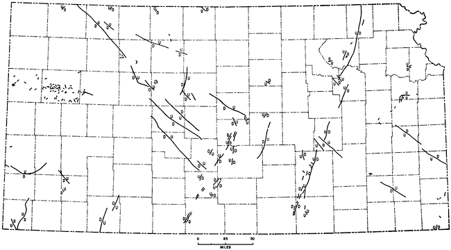
Few faults in Permian and Pennsylvanian rocks in eastern Kansas have been noted (Pl. 27B). Those described are local in nature and of small displacement, usually less than 25 feet. Along the northeastern side of the Silver City Dome, in Woodson County, strata have been displaced as much as 200 feet in a fault associated with intrusive material. The Worden Fault in Douglas County (O'Connor, 1960) is the longest recognized on the surface in eastern Kansas. The Worden and minor faults in southeastern Osage County and northwestern Franklin County occur along a northeast-trending disturbed zone extending for at least 50 miles. The cause of this disturbance is not known.
Evidence of extension of the Chesapeake Fault Zone from Missouri into Kansas has recently been recognized. Although it is not continuous, the northwest-trending disturbed zone is traceable for a distance of almost 600 miles in Missouri, Kansas, and Nebraska. The structure is essentially a graben 6 to 10 miles wide with the floor downdropped as much as 1,000 feet. In Wabaunsee County the Nemaha Anticline is cut by the feature. Several similar, parallel structures are discernible, but at present it is not possible to outline them.
A major zone of faulting occurs along the length of the Nemaha Anticline. In Kansas the Humboldt Fault borders the eastern flank of the Nemaha in its northern part. On the surface, displacement may be up to 100 feet (Condra, 1927). The Humboldt and associated faults are known to cut Precambrian and lower Paleozoic rocks discontinuously along the eastern flank of the Nemaha for the entire length of the state. To the south, in Cowley and Sumner Counties, oil is produced from fields located on small horsts on the crest of the Nemaha Anticline.
Many faults are known or believed to cut Precambrian and lower Paleozoic rocks on and adjacent to the Central Kansas Uplift. The Rush Rib, bounded by faults, is a large horst. Other features such as the Ellsworth, Fairport, and Voshell Anticlines are faulted. None of these faults are known to reach the surface.
Throughout western Kansas there are numerous small faults in Cretaceous beds, especially in the Niobrara Formation, although they are not usually mapped. Several disturbed areas similar to the one in northwestern Ellis County are known (Pl. 27C, 27D). Faults are profusely displayed along Smoky Hill River, where the Cretaceous strata are well exposed. In southwestern Kansas, faults are difficult to recognize on the surface in an area lacking traceable marker beds; however, the Crooked Creek, Fowler, and Syracuse Faults have been verified by test-hole drilling.
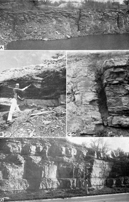
Little work has been done on jointing in Kansas, although the joints are extensively developed (Pl. 28, 29). In regard to northeastern Wilson County, Wagner (1961) reported:
Plate 28--A, Dipping beds along north side of fault on Silver City Dome, Woodson County (NE sec. 32, T. 26 S., R. 15 E.). B, Small normal fault in Fort Hays Limestone in road cut on U.S. Highway 36, Jewell County (SW SE sec. 16, T. 3 S., R. 7 W.). C, Joints in South Bend Limestone, Allen County (NE sec. 27, T. 23 S., R. 18 E.). D, Joints in Elgin Sandstone, Chautauqua County (sec. 15, T. 35 S., R. 10 E.).
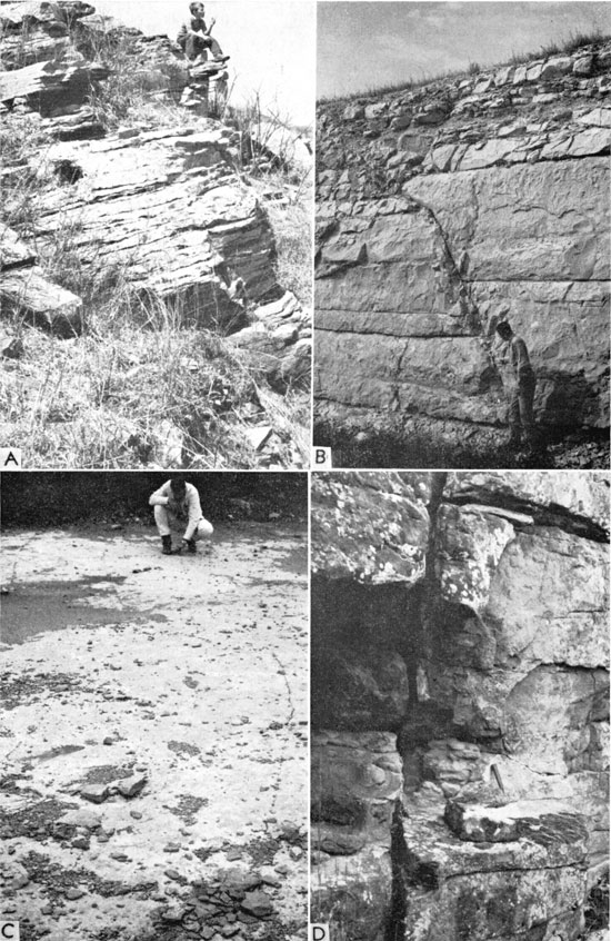
Plate 29--A, Joints in Drum? Limestone buildup in Montgomery County just southeast of Independence (NW sec. 5, T. 33 S., R. 16 E.). B, Note direction of joints in Leavenworth Limestone is different from that in overlying black Heebner Shale; on Kansas Turnpike about 3 miles west of West Lawrence Interchange, Douglas County. C, Small fault with approximately 1 foot of displacement in Stoner Limestone; on Kansas Turnpike at Mile 14, Wyandotte County. D, Well-jointed Fort Riley Limestone exposed on Kansas Highway 18 at west edge of Junction City, Geary County.
A system of joints is well developed in the [Altoona] quadrangle. The joints fall into two general groups that trend about N 55° E and N 35° W. Observations taken at the outcrop established their major trends and vertical dips, but most of the trends . . . were taken directly from aerial photographs. . . . The joints are well developed and clearest on the photographs in limestone units 15 to 30 feet thick; they are obscure but detectable in sandstone units.
In Franklin County (NE sec. 24, T. 18 S., R. 18 E.), S. M. Ball (personal communication) measured a joint system developed in the Haskell Limestone with trends of N 580 W, N 20° W, and N 23° E. In the Reading Limestone in the spillway of the Atchison State Lake, C. K. Bayne (personal communication) noted a joint system having northwest, northeast, and east-northeast trends.
It has long been recognized that some of the drainage in Kansas is controlled by a fracture pattern. Merriam (1955e, p. 82) stated:
Some of the drainage in western Kansas gives the impression of being affected in some way by this structural pattern. It is especially noticeable where the Arkansas River flows in a zig-zag manner, first northeast, then southeast, etc.
In northwestern Kansas, drainage patterns trend approximately N 55° E, N 25° W, and N 45° W and are probably controlled by a fracture pattern in bedrock. This pattern is evident on topographic maps and is visible from the air, especially in early morning or late afternoon.
Further work on fracture patterns in Kansas is warranted.
Prev Page--Development of Present Structure || Next Page--References
Kansas Geological Survey, Geologic History of Kansas
Comments to webadmin@kgs.ku.edu
Web version April 2006. Original publication date Dec. 1963.
URL=http://www.kgs.ku.edu/Publications/Bulletins/162/08_patt.html