![]()
Prev Page--Present Structure || Next Page--Structural Patterns
Development of Present Structure
Interpretation of the development of present structure is based on a study of isopachous maps, supplemented by structural development cross sections and a study of the stratigraphy. The incompleteness of the rock sequence, of course, makes it impossible to know the exact calendar of events; however, many valid assumptions can be drawn from the preserved record. It is unlikely, for instance, that any extraordinary catastrophic events in the interval of time not represented by rocks would fail to leave some identifying recognizable mark in the remaining rock record. Many events in geologic history doubtless have passed by unrecognized and unappreciated, but these happenings must have been of the same order of magnitude and development pattern as those that are known. As an extreme, for example, it is unthinkable that in post-Precambrian time Kansas was ever depressed to abyssal depths of the ocean, elevated sky high in mountains, or converted to a sizable volcanic terrain.
An isopachous, convergence, or thickness map shows in three dimensions thickness of rocks between any two selected horizons. If both surfaces were originally subhorizontal, an isopachous map would reveal the total structural movement of the lower surface when the upper surface was undisturbed. If one of the surfaces was an erosional surface of considerable relief, the isopachous map would show the topography of that surface. These principles have been set forth and elaborated on by Wallace Lee, whose summary is presented here (1954b, p. 69).
A map depicting the thickness of a sequence of rocks between surfaces that were once flat or relatively flat records the structural movements that occurred between the development of the limiting surfaces. Such an isopachous map is essentially a structure map of the first surface at the time of the second. The accuracy with which such maps reveal the structural movements that took place during the interval depends on how closely the limiting surfaces approached a plane. The deformation is most accurately revealed where the confining surfaces were depositional. Erosional surfaces of low topographic relief may be used to reveal regional warping of broad areas. The relation of the sequence of rocks to underlying and overlying formations determines the time of movement. Isopachous maps that include sequences of formations whose thicknesses were separately controlled by conflicting patterns of folding express a composite of both movements and reveal neither.
As pointed out previously, the more nearly complete the rock record, the better may be interpretation of past events. The maximum post-Precambrian rock section in each province is listed on Table 5. The amount and age of rocks present in each province is significant and should be kept in mind in interpreting the structural history of that element.
Table 5--Maximum post-Precambrian rock thickness in areas indicated.
| Pre-Desmoinesian post-Mississippian structural features |
Maximum post-Precambrian rock section, thickness in feet |
|---|---|
| Nemaha Anticline | 3,000 |
| Cambridge Arch | 4,500 |
| Central Kansas Uplift | 5,000 |
| Pratt Anticline | 5,000 |
| Forest City Basin | 4,000 |
| Cherokee Basin | 3,500 |
| Salina Basin | 4,500 |
| Sedgwick Basin | 5,500 |
| Hugoton Embayment | 9,500 |
For this study, regional convergence (or divergence) maps were constructed for rock divisions occurring between surfaces represented by each of the structural maps presented here. Additional information was obtained by preparing several developmental cross sections across the structurally positive areas. Structural development of individual major units is discussed in more detail later.
Pattern of Deformation between Precambrian and Arbuckle Rocks
The pattern of deformation between top of Precambrian and top of Arbuckle (Cambrian-Ordovician) rocks is shown in Figure 116. The most obvious structure on the map is the Southeast Nebraska Arch, called Southeast Nebraska Uplift by Lee (1943), which developed in southeastern Nebraska and northeastern Kansas before Simpson deposition. In Kansas, the area of uplift includes all or parts of Marshall, Pottawatomie, Washington, Riley, Nemaha, and Jackson Counties. Data indicate pre-Simpson elevation of the area, beveling of uplifted formations, and deposition of Simpson rocks on Precambrian granite along the crest of the uplift. Part of the Precambrian area was re-exposed in pre-Pennsylvanian time, but the relative amount of erosion of the basement complex during these periods of exposure is not determinable. Preliminary studies on the configuration of Precambrian basement rock indicate that the arch probably began to form before deposition of Paleozoic sediments.
Figure 116--Isopachous map showing convergence between top of Precambrian rocks and top of Arbuckle rocks. Southeast Nebraska Arch is shown by zero line in northeast, and rocks of interval thicken southwestward into Southwest Kansas Basin, and southeastward into Missouri. Rocks of this interval are missing in small areas in Lyon, Morris, Woodson, McPherson, Ford, and Finney Counties. Contour interval 250 feet.
A pre-St. Peter syncline plunging southward from Russell and Barton Counties is revealed by the contours. The sequence thickens southward into the ancestral Anadarko or Oklahoma Basin, reaching a maximum thickness of nearly 7,000 feet in Oklahoma (Huffman, 1960). Northwesterly thinning to a featheredge reveals the presence of the Transcontinental Arch farther north in Nebraska. The early history of the Cambridge Arch is obscure, owing to lack of information as to where Pennsylvanian beds are in contact with the Precambrian around the arch, but evidence seems to indicate that the Cambridge Arch was present in Arbuckle time. The Central Kansas Uplift also was mildly active at this time. These two aligned structures represent a thumb-like extension from the major northeastward-trending Transcontinental Arch.
Pattern of Deformation between Arbuckle and Mississippian Rocks
The pattern of deformation in the interval between top of Arbuckle and top of Mississippian rocks is revealed in Figure 117. Because the Mississippian (also Arbuckle, locally) is absent on higher parts of the Central Kansas Uplift, Cambridge Arch, and Nemaha Anticline, no attempt was made to extend the map into those areas. The pattern revealed by the contours is complicated because the tops of both the Mississippian and the Arbuckle are erosional, but it is believed that the erosional relief is considerably less than the regional structural relief.
Figure 117--Isopachous map showing convergence between top of Arbuckle rocks and top of Mississippian rocks. Rocks of interval thicken in northeast Kansas showing formation of North Kansas Basin during this time; in southwestern Kansas, rocks of interval thicken into Hugoton Embayment. Contour interval 100 feet. An Acrobat PDF version of this figure is available.
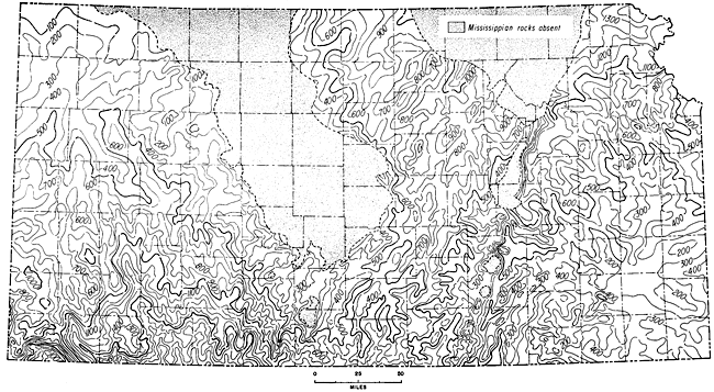
The Nemaha Anticline is evident on the map because of thinning of strata in the interval, mainly Mississippian, and it is believed that the structure was developed near the end of Mississippian time. This conclusion is substantiated by other lines of evidence. At least 1,400 feet of rocks were removed by erosion where both the Mississippian and Arbuckle are missing in parts of Nemaha, Marshall, Washington, Pottawatomie, and Riley Counties, along the crest of the uparched Nemaha axis. In eastern Kansas, the regional dip was to the northwest, although many minor, northwesterly plunging noses and re-entrants were superposed on it. The Chesapeake Fault Zone developed during this time, possibly near the end of the Mississippian, and can be traced southeastward into Missouri. Other northwest-trending grabens also can be seen on the map, indicated by a thicker section.
In southeastern Kansas, the Chautauqua Arch is reflected as a broad, flat area elongated roughly east-west. Rocks in the sequence thicken both northward into the North Kansas Basin and southward into the Oklahoma Basin. Many northeast-trending structures semiparallel to the Nemaha Anticline are revealed, especially in the vicinity of Cowley County. They tend to "wrap around" the west-plunging Chautauqua Arch; these structures are evident mainly because of the truncation of the Mississippian and represent features that developed near the end of Mississippian time.
In the area of the Salina Basin, northeast-trending noses plunge toward the central part of the North Kansas Basin. Structures such as the Abilene Anticline were developed, as well as many of the other northeast-trending features. In the area of the Sedgwick Basin, many northeast-trending elements also were developed. Gradual thickening of the section to the south into the deeper parts of the Sedgwick Basin is evident. The west side of the basin is delimited by the southward-plunging Pratt Anticline, which was smaller in area than now. Mississippian rocks were removed from the crest of the anticline and also from several other small areas along prominent anticlinal structures.
It is difficult to determine the sequence of events in the area of the Central Kansas Uplift because most of the pre-Mississippian record is missing; but from evidence obtained on flanks of the structure, it can be determined that Mississippian rocks, as well as older Paleozoic rocks, probably covered the uplift. These rocks were stripped from the higher part of the structure near the end of the Mississippian and in the early part of Pennsylvanian time; so that in some areas Pennsylvanian beds are in direct contact with the Precambrian basement. The southern end of the Ellsworth Anticline in Ellsworth County is shown, and thinning over the crest indicates structural movement during this interval.
The Hugoton Embayment continued to be downwarped. The axis of the northwest-trending narrow trough seemingly was located in Stevens and Stanton Counties, in extreme southwestern Kansas. The Keyes Dome also shows evidence of upward movement during this time. Many approximately north-trending structures in the embayment are shown on the map. In general, the section thickens toward the axis of the embayment and southward into Oklahoma.
Pattern of Deformation between Mississippian and Lansing Rocks
The convergence map (Fig. 118) is based on three different sets of information. In most of the area the interval mapped is from top of Mississippian rocks to top of the Lansing Group (Missourian, Pennsylvanian). On crests of uplifts--notably the Central Kansas Uplift, Cambridge Arch, and Nemaha Anticline--Mississippian rocks are absent and it was necessary to use the base of the Pennsylvanian rocks for the lower contact. In south-central Kansas, the Lansing is not present and thus the upper datum is top of the Haskell Limestone, which lies stratigraphically a few feet above the top of the Lansing Group. All pre-Desmoinesian post-Mississippian major structural features of Kansas are recognizable on this map.
Figure 118--Isopachous map showing convergence between top of Mississippian rocks and top of Lansing Group. In south-central Kansas, Haskell Limestone was used as upper horizon (dotted line); base of Pennsylvanian rocks was used as lower horizon on higher parts of uplifts where Mississippian rocks are missing (dashed line). Rocks of interval thicken into Hugoton trough, Salina Basin, and Sedgwick Basin. Contour interval 100 ft. An Acrobat PDF version of this figure is available.
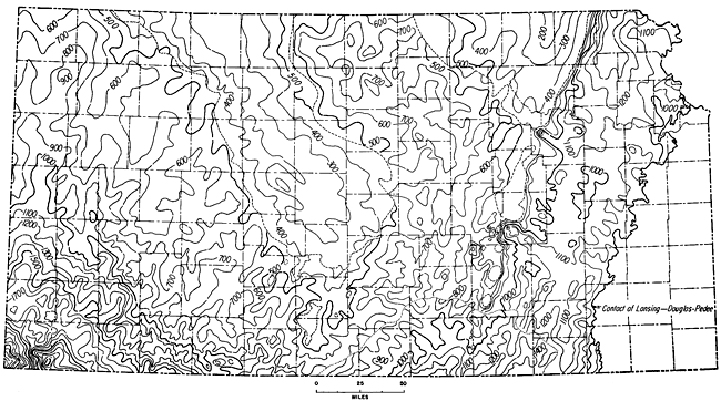
The Nemaha Anticline is the most pronounced structural feature extending across Kansas. This northeasterly trending feature is shown to plunge southwestward at the horizon of the Mississippian while Lansing rocks were yet nearly horizontal and flat. This structural condition has merely been accentuated by subsequent movements. East of the Nemaha axis are the Forest City and Cherokee Basins. The axes of the basins, indicated by the thickest section of rocks, lie near and subparallel to the Nemaha; hence, these basins are decidedly asymmetrical. Information is lacking for most of the eastern flanks of the two basins, but it is believed that the section continues to thin toward the Ozark Uplift farther east, in Missouri (see Berger, 1918). Of prime structural importance is the development of the Chesapeake Fault Complex, trending northwesterly, and a parallel, similar complex farther northeast, in Wabaunsee County. These features are believed to be downdropped blocks or grabens of regional proportions.
West of the Nemaha Anticline, thick and thin areas represent development of several northeasterly trending, southwesterly plunging synclines and anticlines. The Abilene Anticline, for one, is very evident. Movement also occurred on the Voshell Anticline. The Salina Basin appears as a shallow, flat-bottomed synclinal area between the Nemaha Anticline and Central Kansas Uplift. The axis trends northwestward. A shallow saddle separates the southern end of the Salina Basin from the northern end of the Sedgwick Basin.
The Sedgwick Basin in south-central Kansas is distinguished as a northward extension of the Anadarko Basin of Oklahoma. The section thickens rapidly both toward the axis of the Sedgwick Basin and southward. Many minor structures are evident on the flanks of the basin. In the deepest part of the basin, slightly more than 1,300 feet of sediments accumulated during this interval and were preserved.
The backbone of Kansas, the Central Kansas Uplift, showed further structural movement during this interval. In general, the section thins over the crest of the uplift, and several minor features associated with the uplift also showed movement at this time. The same is true for the Cambridge Arch, which is not distinctly separated from the Central Kansas Uplift. The Cambridge Arch-Central Kansas Uplift alignment is about 175 miles long in Kansas, and it extends northward an unmeasured distance into Nebraska.
Extending southwesterly from the southern tip of the Central Kansas Uplift is the Pratt Anticline, which shows structural development at this time. The section thins over the crest of the southerly plunging structure, and Mississippian beds are absent on its crest. This anticline serves to separate the Sedgwick Basin on the east from the huge, sprawling Hugoton Embayment on the west.
The Hugoton Embayment was structurally active during this time. The section thickens toward the southwest into the Hugoton trough in extreme southwestern Kansas. Numerous thinnings and thickenings reveal many minor features on the northeastern flank of the embayment. Most of them plunge southwesterly. At the Kansas-Colorado line, in the northern end of the embayment, the section thins to the west. Although information is lacking, this thinning may represent movement of the Las Animas Arch, which is present farther west, in eastern Colorado.
The Keyes Dome, in Morton County in extreme southwestern Kansas, is a sharp structural feature that limits the Hugoton trough on the southwest. It was actively rising during this interval.
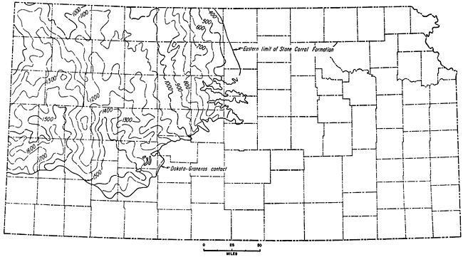
Pattern of Deformation between Lansing and Stone Corral Rocks
Information regarding structural development between Lansing and Stone Corral rocks (Fig. 119) is also derived from three sets of data. For central and western Kansas, west of a line extending from Smith County on the north to Barber County on the south, the contours represent convergence between top of the Stone Corral Formation (Leonardian, Permian) and top of the Lansing Group (Missourian, Pennsylvanian). East of the eastern limit of the Stone Corral Formation and west of the outcrop of the Florence Limestone, contours show thickness of the section between base of the Florence Limestone (Wolfcampian, Permian) and top of the Lansing Group, except in the southern part of the area in parts of Harper, Sumner, Cowley, Butler, Sedgwick, and Kingman Counties. Here the top of the Lansing is not recognized and thus the bottom datum is top of the Haskell Limestone, which occurs stratigraphically a few feet above the Lansing Group but in the lower part of the Douglas Group (Virgilian, Pennsylvanian).
Figure 119--Isopachous map showing convergence between top of Lansing Group and top of Stone Corral Formation. East of eastern limit of Stone Corral (dashed line), base of Barneston Limestone was used as upper horizon; in south-central Kansas, haskell Limestone was used as lower horizon (south of dotted line). Rocks of interval generally thicken southward into Oklahoma. Contour interval 50 and 100 ft. An Acrobat PDF version of this figure is available.
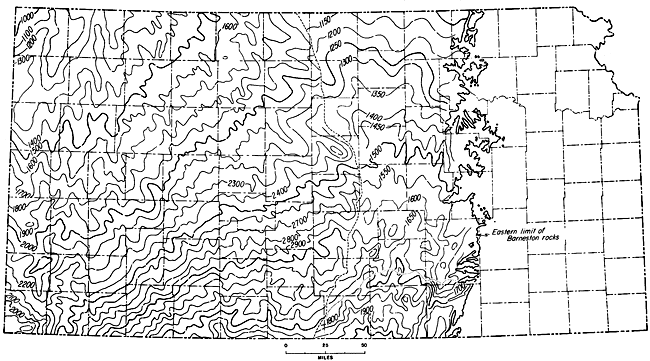
Movement on all major and many minor structural features seemingly continued during this interval, although less actively than earlier in the Paleozoic. The Hugoton Embayment continued to be downwarped, and in southern Clark and Comanche Counties at least 3,600 feet of sediments accumulated. A different structural pattern began to develop during this interval and it eventually ended development of the Hugoton Embayment, which had persisted from the Precambrian. In the northern part of the embayment, in eastern Rawlins, Scott, Thomas, and Logan Counties and western Gove County, movement commenced along the Oakley Anticline, a north-trending, southerly plunging structure, which divided the Hugoton Embayment into the Syracuse Syncline on the west and the Cimarron Syncline on the east. The Oakley Anticline must have been active in pre-Hutchinson (Leonardian) time because it seemingly controlled the depositional western limit of the Hutchinson Salt Member of the Wellington Formation (Fig. 37A).
Movement had all but ceased on the Cambridge Arch and Central Kansas Uplift. The configuration of the contours in southwestern Russell and Ellsworth Counties and south-central Rooks County suggests that minor movement occurred on the Central Kansas Uplift, possibly in pre-Hutchinson time. Subsidiary features along the crest and flanks of the Central Kansas Uplift were subject to slight accentuating movement.
The Pratt Anticline, located in Pratt, Barber, and Comanche Counties, shows some suggestion of movement during this time. Although the axis of the Pratt Anticline is approximately parallel to that of the Nemaha Anticline, structural development of this feature is closely connected with the Central Kansas Uplift.
One of the minor subsidiary structural features of the Central Kansas Uplift which showed pronounced movement during this time is the Ellsworth Anticline. This structure is located in west-central Ellsworth County and is especially prominent on the pre-Pennsylvanian areal geologic map where the Simpson rings the structure cored with Arbuckle rocks.
The axis of the Salina Basin is evident, extending from Jewell County through northeastern Mitchell County and southwestern Cloud, Ottawa, and Saline Counties into northwestern McPherson County. Several minor structures are evident on the flanks of the basin, the most prominent being the Abilene Anticline, which extends from northwestern Riley County through Clay and Dickinson Counties into northeastern Saline County, and the Voshell Anticline, which extends across McPherson County into northeastern Reno County. Both of these anticlinal features are roughly parallel to the Nemaha Anticline.
The Sedgwick Basin axis seemingly is located in south-central Kansas in Harper, Kingman, and Reno Counties. The basin trends approximately south and plunges southward toward Oklahoma. Variation in thickness of the section between top of the Haskell Limestone and base of the Florence Limestone in the Sedgwick Basin is more pronounced than in other basinal areas, possibly because of nearness to the hingeline between the shelflike area and the geosynclinal area to the south.
The Nemaha Anticline is most evident from Chase County through Butler County into southeastern Sumner County. It trends roughly northeastward and plunges southwestward. If the upper datum bed were present farther east, so that it would be possible to map the interval, undoubtedly the presence of the Nemaha Anticline would be reflected by the contours, showing, of course, that the Nemaha was tectonically active at this time. It is also possible that the Forest City and Cherokee Basins would be revealed.
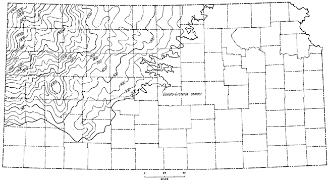
Pattern of Deformation between Stone Corral and Dakota Rocks
Inasmuch as the Stone Corral (Leonardian, Permian) is an evaporite and the Dakota (Cretaceous) is overlain by the Graneros Shale, which has a variation in thickness of not more than 30 feet in 200 miles, the upper surfaces of both the Stone Corral and Dakota must originally have been essentially flat (Lee and Merriam, 1954a). Thickness of the section, therefore, reveals structural movements that occurred between the deposition of the Stone Corral and the Dakota (Fig. 120). Data for depicting thickness of the section between these two surfaces are even more sparse than for the previous thickness maps.
Figure 120--Isopachous map showing convergence between top of Stone Corral and top of Dakota Group. Map reveals that Oakley Anticline, a south-plunging structure, and associated Syracuse and Cimarron Basins were formed during this interval. Thinning over crest of Cambridge Arch suggests movement on that structure during this time. Contour interval 100 feet. An Acrobat PDF version of this figure is available.
The map shows no arching of the Central Kansas Uplift as a major structural feature during this time, but only tilting of the area toward the southwest (toward the Hugoton Embayment). Upward movement of the southeastern end of the Cambridge Arch is suggested by a bulge in the 1,000-foot isopach in Norton County.
The Las Animas Arch is west of the area of the map, but it grades into the western limb of the Hugoton Embayment. Uplift on the northeastern flank of the Las Animas Arch in Kansas was imposed upon the Stone Corral after Permian time.
The general pattern of the Hugoton Embayment shown by the contours is subsidence. The most striking and unexpected structural feature is the prominence of the Oakley Anticline, a southerly plunging anticline extending southward from Thomas to Finney County. Although it began to form earlier, its structural relief (on the Stone Corral) exceeded 200 feet in Dakota time. It is flanked by structural basins: that on the west, in Kearny and Wichita Counties, is the Syracuse Basin; that on the east, in Lane and Finney Counties, is the Cimarron Basin.
The northern end of the post-Stone Corral salt beds of the Nippewalla Group (Fig. 37B) seems to have been confined by the west flank of the rising Oakley Anticline, although farther south the salt beds cross the projected axis of the fold.
It is probable that many secondary structures were developed during this period, but only a few are clearly revealed by available data. Local thinning of the sequence on the Stuttgart-Huffstutter Anticline and on the Sunny Slope Anticline indicates their pre-Cretaceous, or, strictly speaking, pre-Dakota origin. More detailed contouring of the thickness will probably reveal other areas of pre-Cretaceous structure.
Pattern of Deformation between Dakota and Ogallala Rocks
At the end of the Cretaceous Period, Mesozoic deposits in Kansas dipped northwestward into the Denver Basin. This pattern was maintained and possibly accentuated during Cenozoic time (Merriam and Frye, 1954, p. 61). Because the structural pattern was about the same from Dakota to the end of Niobrara time, it can be assumed that the convergence map (Fig. 121) represents the movement that took place after deposition of the Niobrara Formation and before formation of the "Algal limestone." The contours reveal a general northwestward dip of the Dakota into the Denver Basin by Pliocene time.
Figure 121--Isopachous map showing convergence between top of Dakota Group and top of "Algal limestone." Rocks of interval thicken northwestward into Colorado. Shallow Water Basin is evident as a depressed area in Scott County. Contour interval 100 feet. An Acrobat PDF version of this figure is available.
An exception to the prevailing regional dip is found in the Shallow Water Basin of Scott County, which has at least 100 feet of closure. A faint suggestion of a syncline plunging northward is observed in western Gove County and eastern Thomas County and is judged to be the marginal syncline that developed chiefly in Late Cretaceous time (Lee and Merriam, 1954a). It may have developed further during Cenozoic time. Several other minor anticlines and synclines are recognizable on the map. They have a northwestward trend and plunge to the northwest into the Denver Basin.
As the present regional dip of the Dakota is to the north rather than to the northwest, it is judged that this area was tilted toward the east, both before and after deposition of the "Algal limestone." The latter is assumed to have been deposited on a uniform slope having somewhat less eastward dip than it does at present.
Minor and local structural movements may have taken place during the Cenozoic Era, but major Kansas structural features--the Central Kansas Uplift, Cambridge Arch, and Western Kansas Basin--show no evidence of movement then. Epeirogenic movements predominated in the Cenozoic in western Kansas.
Recent Structural Development
Earthquakes are the only perceptible means for man, in his short life span, to determine which structural features are active; therefore, a correlation between earthquakes and structure should indicate which structures, if any, are continuing to develop (Merriam, 1956).
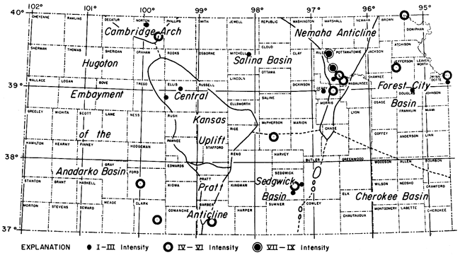
History indicates that earthquakes in Kansas have not been numerous, frequent, or intense, although 41 have been recorded since 1811 (a list of earthquakes is given in Appendix E). [Note: Two additional shocks were felt in northwestern Missouri and northeastern Kansas on December 25, 1961 (Dellwig and Gerhard, 1962).] Of these, 24 had epicenters within Kansas; the others were located in adjacent areas--eastern Nebraska, western Missouri, Oklahoma, and the Panhandle of Texas. Most of the earthquakes having epicenters in Kansas are clustered in two areas in the eastern part--in eastern Riley County, western Pottawatomie County, and Geary County; and in Sedgwick County in the vicinity of Wichita (Fig. 122).
Figure 122--Map showing relationship in Kansas of earthquake epicenters to major pre-Desmoinesian post-Mississippian structural features. Twenty-four earthquakes have been recorded since 1867; frequency of earthquakes along Nemaha Anticline suggests that it is mildly tectonically active (adapted from Merriam, 1956).
The time-intensity relation of earthquakes that had epicentral areas in Kansas is shown in Figure 123, where time is plotted as the abscissa and intensity as the ordinate. The plot reveals moderately intense earthquakes, about VIII, in 1867 and 1906.
Figure 123--Time-intensity relation of earthquakes that had epicenters in Kansas. Columns with a star indicate earthquakes occurring along trend of Nemaha Anticline (adapted from Merriam, 1956).
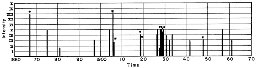
Since the total time involved is short, the periodicity, or seeming regularity, of the earthquakes may give an erroneous impression. If stronger earthquakes occur with the regularity suggested by the frequency plot, there should have been one in 1825 and another in about 1950, but no earthquakes were reported at either time. Nevertheless, the fact that a quake was not recorded in the early 1800s in Kansas is not surprising, because few people inhabited the area at that time, and records were poor. It is also possible that the frequency rate is decreasing, so that the time interval between stronger shocks is increasing. If this is true, then it will be a good many decades before any evaluation as to frequency can be made.
Relation of Earthquakes to Structural Features
As part of the Central Stable Region, Kansas probably was never subjected to intense earthquakes, such as are now known in the mobile belts of the world. The tectonic history has been one of gentle uparching and downwarping of structural elements.
The most obvious correlation of earthquakes to structure is along the Nemaha Anticline, where at least 10 of the earthquakes (in Riley, Pottawatomie, Geary, Sedgwick, and Sumner Counties) occurred in reasonable proximity to the axis of the anticline (Fig. 122). It is also noteworthy that the strongest earthquakes (1867 and January 7, 1906) have occurred along this structure. This relation of seismic activity to the Nemaha Anticline has been noted previously by Lee (1954a) in regard to the earthquake on April 9, 1952, which had its epicentral area in Oklahoma. The area affected by the earthquake corresponds almost perfectly with the Nemaha Anticline. Lee concluded that because there was no observable displacement of the surface rocks, the quake was the result of minor adjustments in the deep-seated rocks and that similar movements probably have occurred intermittently since Permian time. It is curious that the epicenters of all 10 earthquakes should be located west of the anticlinal axis. One explanation for this may be that the earthquakes occurred along a series of reverse faults that dip westward along the east side of the structure. Evidence of reverse faulting has been found in east-central Nemaha County by Wallace Lee (personal communication), in Wabaunsee County by Smith and Anders (1951), and in Richardson, Nemaha, and Otoe Counties, Nebraska, by E. C. Reed (personal communication). Faults are also known at various other places along the Nemaha Anticline in Kansas and Oklahoma. It may be concluded, then, that active tectonic development by faulting is taking place at the present time along parts of the Nemaha Anticline.
The relation of other earthquakes to structural features in Kansas is not easy to interpret. Two earthquakes of moderate intensity occurred on the Cambridge Arch, and two small ones occurred at the northern end of the Central Kansas Uplift. One small earthquake also occurred in the Salina Basin, as well as a moderate one in the area between the Sedgwick and Salina Basins. Two earthquakes of moderate intensity have occurred in the southern part of the Hugoton Embayment; these possibly could be related to minor adjustments in areas adjoining the Amarillo Uplift. Recently an earthquake of moderate size occurred in south-central Kansas on the Pratt Anticline. No earthquakes have been recorded in the Cherokee Basin. Several that have occurred in the Forest City Basin could be adjustments to the uplift of the Nemaha Anticline or the result of other factors.
The focal depths of earthquakes affecting Kansas are relatively shallow, ranging from approximately 16 to 38 miles. These depths would indicate that the hypocenters are located above the Mohorovicic discontinuity and within the granitic crust (J. A. Peoples, personal communication, June 22, 1962). Table 6 gives approximate focal depths of some earthquakes in the Midcontinent. The figures are relative, not absolute, depths.
Table 6--Approximate focal depths of some earthquakes affecting Kansas in recent years. Depth of focus computed from Gutenberg's formula (Gutenberg and Richter, 1942, p. 174) r/h=SQRT(I0(I0/3-1/2) - 1, where r is radius of perceptibility, I0 is maximum intensity, and h is depth of focus. These figures should be regarded only as relative magnitudes of depth.
| Date | Location of epicenter | Hypocenter |
|---|---|---|
| September 23, 1929 | Manhattan, Kansas | 23 miles |
| October 21, 1929 | Junction City, Kansas | 22 miles |
| March 1, 1935 | near Tecumseh, Nebraska | 29 miles |
| June 19, 1936 | Texas Panhandle | 38 miles |
| March 11, 1948 | northwest of Amarillo, Texas | 27 miles |
| April 9, 1952 | near Oklahoma City, Oklahoma | 19 to 37 miles |
| January 6, 1956 | Barber County, Kansas | 32 k, (20 miles)1 |
| April 13, 1961 | northwest of Norton, Kansas | 20 to 50 miles2 |
| December 25,1961 | near Excelsior Springs, Missouri (2) | 35 km (22 miles); 25 km (16 miles)3 |
| 1Dellwig (1956). 2J. A. Peoples. personal communication. 3Dellwig and Gerhard (1962). |
||
Because of the paucity of destructive earthquakes in Kansas, it can be concluded that the area is a relatively stable one; however, the relation of earthquakes to the Nemaha Anticline shows that the anticline is tectonically active at present. The other structural features in Kansas may be regarded as stable.
Development of Major Structural Features
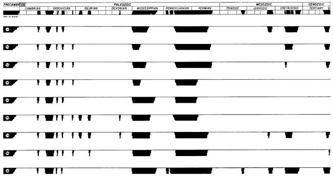
Gross aspects of structural development of each of the major structural features are shown graphically in Figure 124. Information for this generalized chart was obtained, at least in part, from: Merriam and Atkinson (1955) and Parkhurst (1959a) on the Cambridge Arch; Lee (1953) on the Central Kansas Uplift; McCoy (1953), Merriam (1955b), Mehl (1959), and Hays (1961) on the Hugoton Embayment and Pratt Anticline; Lee (1956) on the Salina Basin; Kelly (1961) on the Sedgwick Basin; Lee (1943) and Lee and others (1946) on the Forest City Basin; Lee and Merriam (1954b) on the Nemaha Anticline; and Goebel and Merriam (1959) on the Cherokee Basin. This chart, although generalized and greatly simplified, gives a graphic comparison of the movements of different structural elements through time. Post-Paleozoic movements in eastern Kansas can only be assumed, owing to lack of Mesozoic and Cenozoic deposits in this region. Even in western Kansas incompleteness of the rock record seriously hampers interpretation. The extent of this hindrance may be estimated by noting the large gaps in the column in Figure 125.
Figure 124--Graphic representation of structural evolution of major features in Kansas. Divisions of columns indicate approximate position of stratigraphic horizons used for convergence maps. Arrows indicate direction of movement, up or down; curved arrows with directional motion indicate direction of tilting.
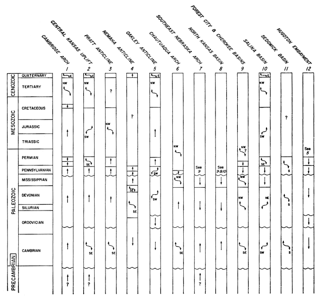
Figure 125--Beds present in major pre-Desmoinesian post-Mississippian structural elements. 1, Cambridge Arch; 2, Central Kansas Uplift; 3, Central Kansas Uplift; 3, Pratt Anticline; 4, Nemaha Anticline; 5, Cherokee Basin; 6, Forest City Basin; 7, Salina Basin; 8, Sedgwick Basin; and 9, Hugoton Embayment. An Acrobat PDF version of this figure is available.
Prev Page--Present Structure || Next Page--Structural Patterns
Kansas Geological Survey, Geologic History of Kansas
Comments to webadmin@kgs.ku.edu
Web version April 2006. Original publication date Dec. 1963.
URL=http://www.kgs.ku.edu/Publications/Bulletins/162/07_devel.html