![]()
Prev Page--Stratigraphy--Paleozoic || Next Page--Stratigraphy--Precambrian
Stratigraphy, continued
Igneous and Metamorphic Rocks of Unknown Age
Igneous rocks are exposed in several small outcrops in Riley and Woodson Counties. In Riley County, in northeastern Kansas, five plug-like intrusions of basic igneous rock crop out in an area of lower Permian sedimentary rocks (Pl. 22A): the Bala intrusive (NW sec. 6, T. 9 S., R. 5 E.), Leonardville (SE NW sec. 22, T. 8 S., R. 5 E.), Randolph 1 (SE NW sec. 35, T. 6 S., R. 6 E.), Randolph 2 (NE sec. 35, T. 6 S., R. 6 E.), and Stockdale (NW SE sec. 23, T. 8 S., R. 6 E.). Cook (1955) related that ". . . all the serpentine masses are somewhat similar in that (1) they consist of a dark green, fine-grained ground mass of igneous rock containing many xenoliths composed of fragments of the neighboring sedimentary rocks; (2) they tend to form small mounds on the landscape, thus indicating their greater resistance to weathering and erosion; and (3) they are magnetic." Moore and Haynes (1920) described the rock at Bala in detail as a green, serpentinized and carbonatized, porphyritic, peridotite breccia containing numerous shale xenoliths. Magnetic studies of Bala by Dreyer (1947a) indicate that the intrusive is a vertical, eastwardly plunging dike. Cook (1955), on the basis of magnetic studies, postulated that Randolph 1 ". . . is possibly a truncated cylindrical or prismatic body plunging to the south-southeast . . ."; Randolph 2 ". . . is possibly a south-southeasterly plunging, fingerlike pipe . . ."; Stockdale ". . . is possibly a parallelepiped-shaped body plunging south-southeast . . ."; and Leonardville ". . . is interpreted as a northwesterly trending, vertical or steeply dipping dike that is more than 1700 ft long and locally up to 500 ft wide. . . ." Cook concluded that location of the intrusions may have been controlled by joint sets associated with the Abilene Anticline. Previously Taylor (1950) had suggested that they may have been emplaced along gash fractures associated with a basement strike-slip fault.
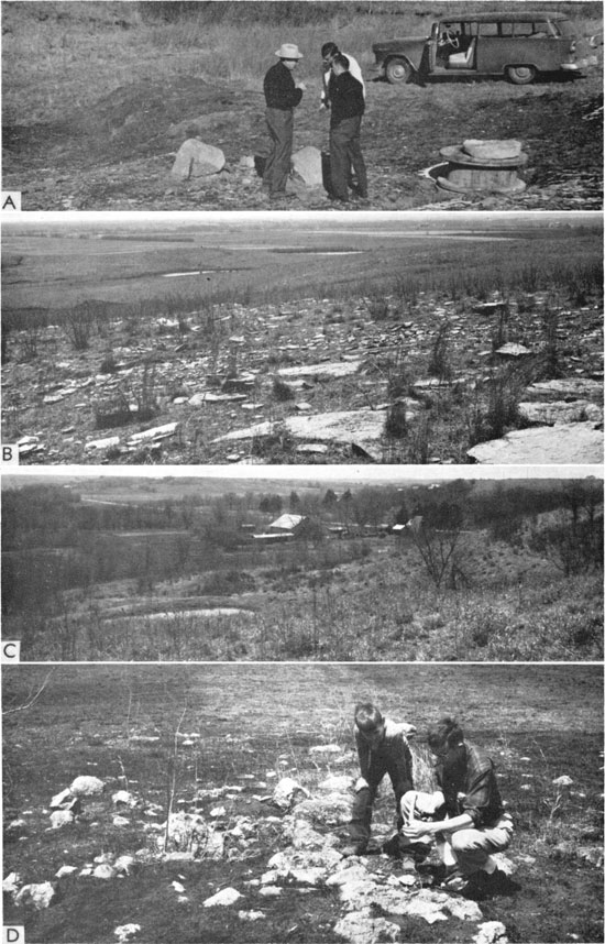
Plate 22--A, Peridotitic intrusive rock exposed on Stockdale Dome, Riley County (NW SE sec. 23, T. 8 S., R. 6 E.). B, Metamorphic rocks on north flank of Silver City Dome, a peridotitic intrusion, Woodson County (sec. 29 and 32, T. 26 S., R. 15 E.). C, Western flank of Rose Dome, Woodson County (sec. 13, T. 26 S., R. 15 E.). D, Granite exposed on the apex of rose dome.
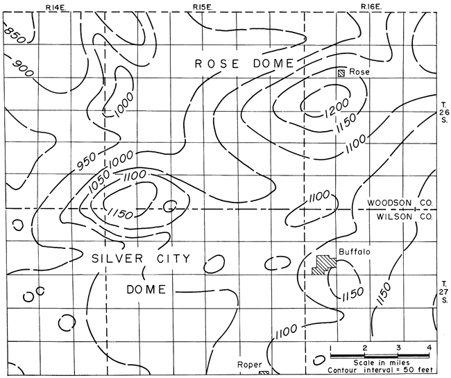
In Woodson County, on the crest of Rose Dome (sec. 13, T. 26 S., R. 15 E.), coarse-grained granite crops out over about 40 acres (Pl. 22C; 22D). Rocks of Missourian age are slightly arched surrounding the granite outcrop (Fig. 84). The origin of the granite was a subject of speculation for some time before Knight and Landes (1932) suggested that the granite is intruded as a dike. This explanation has been accepted since that time mainly on the premise that contact metamorphic zones occur in the intruded Pennsylvanian shales; however, recently, some doubt has been expressed that contact zones are present (P. C. Franks, personal communication).
Figure 84--Structure map on base of Plattsburg Limestone (Missourian) in southern Woodson and northern Wilson counties showing configuration of Rose and Silver City Domes (from Hambleton and Merriam, 1955) Contour interval 50 feet..
[Note: Recent developments have again opened the question of the relation of the Rose Dome to the exposed granite; therefore, a more complete explanation is in order here. The granite boulders in Woodson County were found by W. H. Twenhofel in 1915 and subsequently described (1917a); he concluded that they were ice-rafted to their present position in Pennsylvanian time. After Powers (1917) described the occurrence of granite at shallow depths in eastern Kansas, Twenhofel (1919) suggested that the source for the granite boulders possibly was from the northwest (from the buried granite ridge exposed in early Pennsylvanian time) rather than the southeast. Twenhofel and Edwards (1921) suggested that the granite at Rose could be an outcrop of a dike, if some associated sedimentary units exhibited metamorphism as reported. In 1926, Twenhofel reported that new exposures of shale in contact with the granite showed alteration and thus the granite was intrusive; this explanation has been accepted by most workers. He later noted some wells drilled on the dome encountered peridotite which probably was in some way associated with the granite.
Recently, however, the granite was dated 1220 million years by the Rb/Sr method by the U.S. Geological Survey for the Air Force Office of Scientific Research (contract No. 49(638)-1115) as part of the Advanced Research Agency Project VELA UNIFORM (E. G. Lidiak, written communication, August 21, 1963). Thus, the age of the granite seemingly is Precambrian, and relation of the granite to the Rose Dome is again open to speculation. The most satisfactory explanation based on present evidence is that the granite is blocks of Precambrian basement that were incorporated as xenoliths in an intrusive peridotite plug, and that the boulders on the present surface are residuals weathered out of the igneous rock.]
Also in Woodson County, at a locality known as Silver City, a few miles southwest of the granite exposure, peridotitic igneous rocks are exposed along with fine-grained quartzite altered from sandstone of the Douglas Group (Virgilian). The Hills Pond Peridotite is exposed in the NE sec. 32 and NW sec. 33, T. 26 S., R. 15 E. The largest exposure of peridotite and metamorphic rocks (Pl. 22B) is associated with a west-northwest-trending, high-angle north-dipping fault. Wagner (1954) said of the dome, "The doming is apparently due chiefly to the injection of layers of igneous material into the Pennsylvanian sequence, increasing the thickness of the stratigraphic interval between the top of the Mississippian rocks and the base of the Kansas City group by more than 200 feet near the apex. . . ." Wagner postulated that the magma was intruded along the fault, spreading laterally into the Pennsylvanian beds ". . . where it crystallized rather slowly into biotite, olivine, augite, hypersthene, apatite, and titanite, forming a medium-grained mica peridotite." The present configuration of the structure is shown in Figure 84.
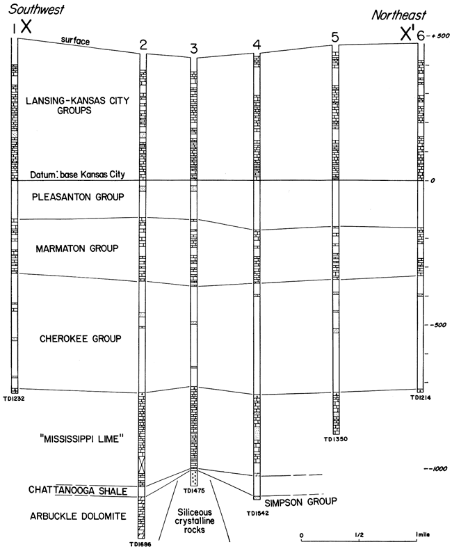
The Neosho Falls Dome (Fig. 85) is an elongate feature to the north. Closure amounts to about 60 feet on top of the "Mississippi lime," which occurs at a depth of 1,150 to 1,200 feet. Much more data for preparing a structure map are available now than were available to Knight and Landes in 1932. They believed that the siliceous crystalline rocks encountered in the Southern Kansas Gas Company No. 8 Harris well (SW SW SW sec. 8, T. 24 S., R. 17 E.) in Woodson County are metamorphosed post-Cambrian sediments rather than a buried hill of metamorphosed Precambrian rock (Fig. 86); and they concluded that (1932, p. 11) ". . . the replacement of the sediments underlying the black shale by silica and magnetite was effected by solutions emanating from an underlying igneous mass, which, by the force of its intrusion produced the Neosho Falls dome." Other structures formed by intrusion of igneous material, such as the Silver City and Neosho Falls Domes, probably are present in southeastern Kansas.
Figure 85--Structure map contoured on top of "Mississippi lime" of Neosho Falls Dome in northeastern Woodson County. Contour interval 10 feet. X-X' is line of cross section in Figure 86.
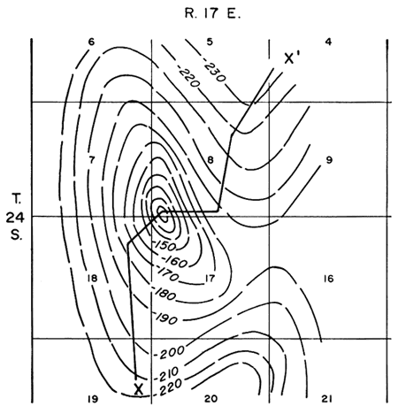
Figure 86--Southwest-northeast cross section of Neosho Falls Dome, northeastern Woodson County. Location of cross section shown in Figure 85. Siliceous crystalline rocks are present in well 3. Information based on drillers logs.
The age of outcropping igneous rocks in Kansas is unknown. Because vulcanism in Arkansas and Texas is believed to be of Cretaceous age, it has been suggested that the igneous rocks in Riley County are Cretaceous. Thermoluminescence studies by Pearn (1959), however, indicate an early Tertiary age for the Silver City intrusive. A potassium-argon date of 65±5 million was made recently for the Silver City material, indicating a very early Tertiary date (W. C. Pearn, personal communication).
Because the Riley County basic rocks are fine grained and contain inclusions of the adjacent sediments that are not greatly altered, it seems probable that the material was emplaced in a plastic state under overlying rocks (Jewett and Merriam, 1959). It is believed that the pre-Cretaceous and early Cretaceous land surface in eastern Kansas was at about the same position as the present surface in relation to lower Permian strata; hence, a few hundred feet of Cretaceous sediments may have been the only cover originally above the intrusions, and igneous material may even have reached the surface. It is also probable that the peridotite at Silver City was emplaced under the same conditions as the Riley County peridotite. Because the granite at Rose Dome is coarse grained, it probably cooled under a considerable thickness of rock.
Additional references on Kansas intrusives and associated metamorphic rocks include: Hay (1883), Jewett (1941b), Knight and Landes (1932), Mudge (1881), Schaffner (1938), Twenhofel (1917a; 1917b; 1926), Twenhofel and Bremer (1928), Twenhofel and Edwards (1921), and Weidman (1933).
Prev Page--Stratigraphy--Paleozoic || Next Page--Stratigraphy--Precambrian
Kansas Geological Survey, Geologic History of Kansas
Comments to webadmin@kgs.ku.edu
Web version April 2006. Original publication date Dec. 1963.
URL=http://www.kgs.ku.edu/Publications/Bulletins/162/03_strat_d.html