
INFORMATION DISSEMINATION
Research is the first step in understanding
natural-resource issues. Equally important is disseminating the results
of that research, and other information collected by the KGS.
Information Processing, Display,
and Dissemination Systems
The KGS works to transfer water-related information to users, such as
policy- and decision-makers and the public. A vital part of this activity
is the effective display, dissemination, and interactive analysis of data
in a way that converts the information to a usable form. The KGS developed
data management, GIS, and Internet approaches that not only greatly facilitate
the processing and transfer of results from our studies, but also analyze
and present data in a more readily usable form from other studies. The
database and Internet developments are being integrated into Survey-wide
advancements in interactive display and dissemination of information.
Kansans’ Knowledge
about Water
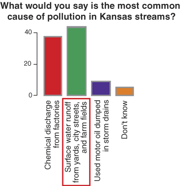
Under contract with the Kansas Water Office, a telephone survey of 1,200
adult Kansas citizens gathered information about the knowledge that Kansans
have about water and State policies concerning its use. Responses were
compared among the 12 river basins in the state, after statistical corrections
for gender bias and urban/rural bias in the sampling. Results show that
Kansans are moderately knowledgeable about the vocabulary of water resources,
water use, and conservation, but uninformed about the role of State agencies
in water management.
Information and Assessment Report to the Kansas Water Office.
Natural-resource Geoinformatics
Over the coming decades, geoscience research will provide the scientific
basis for important economic and environmental decisions. Research activities
may range from regional-scale evaluation of aquifer or petroleum reservoir
depletion and large-scale fluid movement to the local-scale problem of
modeling fluid transport through a heterogeneous reservoir. To undertake
research on broader scales, earth scientists will require efficient access
across large datasets maintained by individual entities, disciplines,
and research scientists. The earth sciences also require structures and
tools that accelerate the growth and enhance archival and effective use
of earth-science data across the broader earth-science community. This
project involves: 1) developing innovative methods to efficiently organize
and provide seamless online access to critical geospatial information
sources and very large heterogeneous geoscience data sets 2) developing
automated procedures to continuously update databases with new information;
3) creating information-technology tools that can organize, access, query,
model, analyze, display, and distribute data related to earth systems
and their processes pertinent to an user-defined question; 4) efficiently
linking and maintaining database servers containing near-real-time data
across states, organizations, divergent geoscience disciplines, and numerous
databases. The KGS’s digital petroleum atlas (www.kgs.ku.edu/DPA/dpaHome.html),
carbon sequestration information project (www.midcarb.org/),
Kansas Energy Information Network, oil and gas database development, and
Gemini project are all part of that effort.
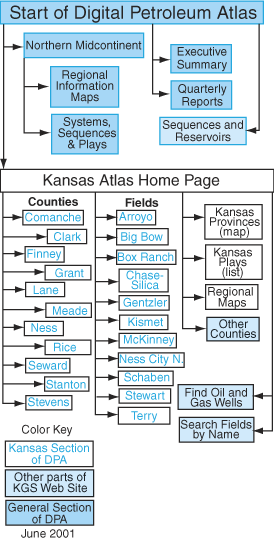
Web-site map of the Digital Petroleum Atlas.
Public Outreach
As part of Earth Science Week, the KGS sponsored its first field trip
for the general public in the Topeka and Lawrence area in October 2000.
Because of the high level of public interest, the trip was repeated in
April 2001, and a similar trip was conducted in the Wichita area in October
2001. The annual KGS field conference focused on natural-resource issues
in northwestern Kansas in 2001, making stops at the Sternberg Natural
History Museum in Hays, the Nature Conservancy’s Smoky Valley Ranch,
the Northwestern Kansas Groundwater Management District, and the carbon
dioxide oil-recovery project in Russell County. The KGS also provides
information through a publication sales office, data library, library/archives,
and web site.
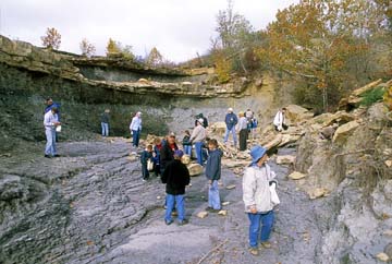
2001 public field trip to Eureka Lake.
List of 2002 Publications—Information Dissemination References
Kansas Geological Survey
Online May 20, 2003
Comments to: webadmin@kgs.ku.edu
URL:http://www.kgs.ku.edu/Publications/AnnRep02/information/information.html