
MAPPING
Mapping is a key component of geologic understanding. Geologic mapping focuses mainly on the age and nature of rock formations at the Earth’s surface and is the beginning point for understanding an area’s geology. Other types of mapping show different elements of the Earth. The KGS is producing new and updated geologic maps, along with a variety of other thematic maps, and is developing new ways of presenting information in a mapped form.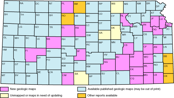
Status of geologic maps.
Geologic Mapping
New geologic mapping continued in Kansas during 2001, possible in part through funding of the National Cooperative Geologic Mapping Program. Counties being mapped during the year included Marshall, Washington, Douglas, Osborne, Barber, Crawford, Gray, Cheyenne, and Hodgeman. In addition digital upgrades of existing geologic maps were undertaken for Wabaunsee and Pottawatomie counties. With field efforts complete, digitizing is underway in many counties including Cherokee, Douglas, Neosho, Comanche, Bourbon, Osborne, Anderson, and Clark. New geologic maps completed during 2001 include Comanche and Anderson counties. Geologic map databases and supporting cartographic databases for Bourbon, Neosho, Osborne, Cherokee, Comanche, Anderson, Clark, and Shawnee counties were completed in 2001 with funding from USGS–STATEMAP and the Kansas GIS Policy Board. In addition, attributed GIS databases of Kansas geology have been prepared for Elk, Montgomery, Shawnee, Russell, Leavenworth, and Phillips counties.
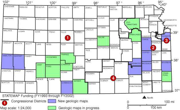
STATEMAP funding for 2001.
Structural Geology and Neotectonics of Kansas
This project examines the nature of surface faults in Kansas and their relationship to fault reactivation and potential earthquakes. Research focuses on specific areas of faulting in Pottawatomie and Chase counties, both located along the trend of the Nemaha Tectonic Zone. The Pottawatomie County study resulted in mapping an uplift structure that that could potentially still be active.
Implementation of Internet Map Service (IMS)
Tools and standards are being developed for serving interactive digital geologic map data and related databases on the Internet. The prototype demonstration involved the geologic map database for Montgomery County, linked to the KGS electronic lexicon database.
Kansas Ecoregions
The KGS collaborated with the Environmental Protection Agency, Kansas Biological Survey, and other State and Federal agencies on a map of ecoregions of the state. The map divides Kansas into regions that are ecologically similar using physiography, geology, soils, natural vegetation, land use, and other environmental criteria.
Development of Cartographic Tools
LEO4, an enhanced system for accurate conversion between location descriptions based on the Public Land Survey System and map coordinate systems (latitude and longitude, UTM, etc.), continues in development. PROFILE is an automated procedure for generating land-surface profiles along transects defined by any series of specified locations, with selectable horizontal scale and vertical exaggeration.
KDB: Development of the Surface Geology Layer
The digital geologic map component of the Kansas Data Base (KDB) will continue to be augmented through interpretation of surface geology represented in previously published maps and other sources with spot checking based on field work and image analysis. This continuing project is funded through the USGS STATEMAP program and the Kansas GIS Policy Board’s GIS Initiative. Recent work has focused on Chase, Lyon, Osage, Wabaunsee, and Pottawatomie counties. These data are being structured in conformance with Federal standards for the national geologic map data model of the National Geologic Map Database Project.
In addition, the Kansas Geologic Names Database (LEXICON) will continue to be expanded and enhanced as a component of the Kansas geologic map data model. The Public Land Survey data in Kansas will be augmented with a complete digital database of Native American land boundaries. This addition is funded by the Kansas Historical Society. Digital Elevation Models (DEMs) will be improved from Level 1 to Level 2 for over 250 quadrangles in Kansas. This work is funded in part by the Kansas GIS Policy Board and a cooperative work-share with the USGS.
Morrison Formation
The Morrison Formation (Upper Jurassic) in Kansas is confined entirely to the subsurface. Studies of the Morrison will focus on recent logs and core studies of the Morrison section from the Amoco Rebecca Bounds well. A long-term aim is to coordinate research with the Morrison Extinct Ecosystem Project, a joint NPS–USGS-funded interdisciplinary study of outcropping Morrison throughout the Western Interior.
Basin Analysis/Geothermics
A contribution to the subject of basin analysis/geothermics was made during 2001 with publication of Geologic Modeling and Simulation, edited by D. F. Merriam and J. C. Davis. This book contained 15 papers that were presented at the International Association for Mathematical Geology’s annual meeting in Cancun, Mexico, in September. Three of the papers were written by KGS scientists.
List of 2002 PublicationsMapping References
Kansas Geological Survey
Online May 20, 2003
Comments to: webadmin@kgs.ku.edu
URL:http://www.kgs.ku.edu/Publications/AnnRep02/mapping/mapping.htm