
ENERGY
Oil and natural gas production remains a crucial component of the Kansas economy, and is a focus of research and service conducted at the KGS. At the same time, the KGS is studying and reporting on alternative forms of energy, such as coalbed methane.
GEMINI (Geo-Engineering Modeling through
Internet Informatics)
This interactive, integrated web site (www.kgs.ku.edu/Gemini/index.html)
is designed to construct real-time geo-engineering reservoir models. Information
assembled from the web site or uploaded by the client (one person or a
team) will be analyzed with an extensive suite of web-accessed analytical
software using intelligent interfaces and tutorial support to accomplish
project development. Projects can range from regional to local and span
problems from complex to simple.
Site map for Gemini web page.
Log Analysis of Subsurface Geology via
the World Wide Web
The KGS web site gives access to a large and expanding database of digital
logs that contain an extraordinary amount of geological information from
the Kansas subsurface, provided that users are conversant with petrophysical
log interpretation and analysis. In this project, traditional methods
of log-analysis training are migrated to a web host, as a distance-learning
module that integrates descriptive linked flat html pages with interactive
Java applets to give hands-on experience in the geological interpretation
of wireline logs.
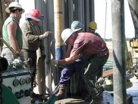
Carbon dioxide (CO2) miscible flooding demonstration.
Improved Oil and Gas Recovery
Kansas’ reservoirs have produced approximately 6 billion barrels
of oil and continue to produce over 30 million barrels per year. Extremely
large amounts of water (produced along with the oil), low recovery factors,
and restricted access to advanced technology place continued production
of this valuable natural resource at or near economic limits. Kansas fields
now require a third phase of development—improved oil recovery.
Improved oil-recovery techniques such as carbon dioxide (CO2)
miscible flooding, horizontal drilling, and controlled hydraulic fracturing
require cost-effective advanced technologies. KGS projects in this area
introduce Kansas producers to potentially useful advanced technologies
and demonstrate these technologies in actual oil-field operations. In
addition, advanced technology is tailored specifically to the scale of
operations appropriate to Kansas producers. Funded by the U.S. Department
of Energy, a $5.4 million CO2 miscible-flood demonstration
project in Russell County represents the first use of CO2
for improved oil recovery in Kansas; the goal is to demonstrate the technical
feasibility of the process in a major Kansas reservoir. The CO2
project also attempts to integrate electric generation, agriculture, ethanol
production, improved oil recovery, and carbon sequestration as a linked
energy system. Associated with this pilot study has been a detailed characterization
of key reservoir properties. Other demonstration projects are focused
on horizontal infill drilling and using numerical simulation to optimize
fracture treatments.
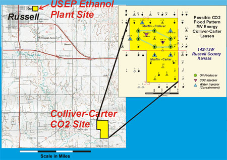
Possible CO2 flood
pattern, Russell County, Kansas.
Integrated Reservoir Systems
and Basin Analysis
The majority of Kansas oil and gas production is operated by small independent
producers that do not have resources to develop and test advanced technologies
(90% of the 3,000 Kansas producers have fewer than 20 employees). Access
to new technology is important for sustained production and increased
financial viability and the overall economic health of the state. Integrated
reservoir characterization and simulation is a new approach that cuts
across the disciplines of geology, geophysics, and engineering to develop
a complete picture of fluid movement in a flow-unit, reservoir, or basin.
The concentration is on application of large quantities of quantitative
data (e.g., core and log petrophysics or well-test information) to build
detailed maps and 3-D volumes that can be input into reservoir simulators
or models of basin-scale fluid movement. Specific projects focus on the
Hugoton natural gas area, specific fields (such as Minneola, Schaben,
Wellington West), 3-D seismic, coalbed-methane assessment, software packages
(such as Pfeffer at www.kgs.ku.edu/PRS/software/pfeffer1.html,
and studies of outcrops that are analogous to oil-producing reservoir
rocks.
Coal and Coalbed Methane
Coalbed methane is a form of natural gas that can be produced from many
Kansas coal beds. Studies in coal resources and coalbed-methane potential
continued during 2001 with partial funding from the U.S. Geological Survey.
These efforts included stratigraphic studies of coals in the Cherokee
and Forest City basins in eastern Kansas. A strong emphasis during the
year was on the coalbed-methane potential in these basins. Considerable
interest developed recently concerning the economic potential of this
commodity in Kansas. Numerous inquiries were handled concerning information
about coal and coalbed methane. At this time, significant economic coalbed-methane
development is occurring in eastern Kansas. In addition, high-resolution
seismic-reflection is being applied to several key characteristics of
coalbed-methane reserves (thickness of the coal seam and overburden; lateral
extent of the gas-bearing coal; and geologic structures, such as faults,
fractures, or cleats).
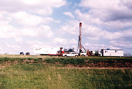
Drilling equipment at coalbed methane site.
Regional Stratigraphic Cross
Sections of Kansas
Approximately 140,000 wells have been drilled in Kansas, and most of them
have wireline logs that are excellent sources of information about subsurface
geology. The KGS is preparing a series of computer-generated cross sections
showing the subsurface geology from the ground surface to the Precambrian
basement along critical corridors across Kansas.
CORRELATOR v. 2.0
Stratigraphic cross sections constructed by computer use CORRELATOR software,
a collection of FORTRAN programs developed at the KGS. The software is
“research-level” functional, but graphical elements must be
added manually on the cross section for an acceptable publication. Currently,
extensions are being added to display stratigraphic columns with lithologic
symbols.
Seismic Signature of Shallow Gas Deposits
in Eastern Kansas
Reservoir-analog studies using high-resolution seismic reflection, outcrop
analysis, and rock core in Montgomery County have produced a variety of
new insights and understanding of deeper oil-producing units in Kansas.
Research funded by Exxon to examine a 5-mile north/ south transect along
the Montgomery/Elk County line that intersects an incised valley included
a high-resolution seismic-reflection image of the upper 1,000 feet.
List of 2002 Publications—Energy References
Kansas Geological Survey
Online May 20, 2003
Comments to: webadmin@kgs.ku.edu
URL:http://www.kgs.ku.edu/Publications/AnnRep02/energy/energy.html