
GEOLOGIC HAZARDS
The KGS mission includes studying the state’s geologic hazards. While the state’s resources are widely recognized, the hazards are less well known. However, 2001 made clear the role that geology plays in natural and human-made hazards, and reinforced the importance of reliable geologic information in dealing with such hazards.
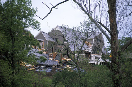
House damaged in 1995 landslide in Johnson County.
Hutchinson Gas Incident
In January 2001, natural gas explosions and fire destroyed two businesses in downtown Hutchinson, and two residents of a mobile home park died of injuries from explosions. Geyser-like eruptions spewed a mixture of natural gas and saltwater. The gas is believed to have moved from a storage site northwest of the city, to Hutchinson, where abandoned brine wells provided a pathway to the surface. At the request of Kansas Governor Bill Graves, the KGS worked with the City of Hutchinson, the Kansas Department of Health and Environment (KDHE), and the local utility, Kansas Gas Service, in the search for possible pathways by which the gas moved into Hutchinson. Seismic investigations were used to locate and characterize the pathway taken by the natural gas. Because of time constraints, only preliminary data processing was possible, but the information was used to locate two wells that were successful in venting gas from the subsurface. The KGS also used electromagnetic methods to find abandoned brine wells. This method successfully located one uncapped abandoned well, 4 inches in diameter and buried at a depth of 5 feet. The KGS also investigated potential land subsidence that might develop after the incident. The KGS also worked with NASA to arrange methane-detecting flyovers. The KGS developed a web site to provide up-to-date information on the situation (www.kgs.ku.edu/Hydro/Hutch/index.html) and continues to work with the City of Hutchinson, KDHE, and Kansas Gas Service. The KGS has submitted a proposal for Federal funds for a more in-depth study of the area’s geology and the geologic issues surrounding the event.
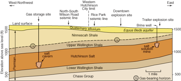
Cross section of Reno County geology, showing the hypothetical movement of gas from a salt cavern to eastern Hutchinson. From Geologic Record, v. 7.2, Spring 2001.
Landslide Hazards of the Kansas City Metropolitan Area
This project examines factors that cause landslides and develops landslide hazard maps for the Kansas City Metropolitan Area. The study used GIS technology and statistical methods to determine the landslide hazards for Atchison, Kansas, and surrounding areas. Landslide hazards in northeastern Kansas are best predicted using the local slope angle and surficial geology. The statistical methodology can be extended to other areas in northeastern Kansas, including Kansas City and its suburbs.
Landslide-prone areas in Kansas, from Public Information Circular 13, March 1999.
Defining Sinkholes by the Surface Wave Technique in a Noisy Environment
A sinkhole developed at Calvert Cliffs Nuclear Power Plant, Maryland, in early 2001. To prevent damage to nearby structures, the sinkhole was quickly filled with dirt. The cause of the sinkhole was a subsurface drainpipe that collapsed due to saltwater corrosion of the corrugated metal pipe. A high-frequency surface-wave survey was conducted to define the sinkhole impact area. Based on this work, a potential sinkhole impact area was tentatively defined.
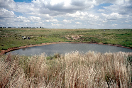
Sinkhole in Pawnee County.
Subsidence Mechanism and Chronology of Central Kansas
High-resolution seismic reflections were used to map the upper 150 meters of the ground surface around and below an actively subsiding sinkhole currently affecting the stability of U.S. Highway 50 in Reno County, Kansas. Primary objectives of this study were to delineate the subsurface expression of this growing salt dissolution-induced sinkhole and appraise its threat to highway stability and the characteristically heavy commercial traffic load. The seismic-reflection data allowed detection, delineation, and evaluation of rock failure and associated episodes of material collapse into voids left after periodic and localized leaching in the Hutchinson Salt Member of the Wellington Formation. Current surface subsidence at the intersection of U.S. Highway 50 and Victory Road is probably related to the reactivation of natural salt-dissolution processes.
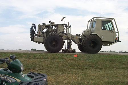
Industrial vibrator used in seismic tests.
List of 2002 Publications—Geologic Hazards References
Kansas Geological Survey
Online May 20, 2003
Comments to: webadmin@kgs.ku.edu
URL:http://www.kgs.ku.edu/Publications/AnnRep02/hazards/hazards.html