![]()
Prev Page--Artesian Water || Next Page--Recovery
Shallow Ground Water in the Artesian Basin
Occurrence
In 1911, Parker (1911, p. 43) wrote that, "The whole artesian valley is supplied with the ordinary ground water, which is found at 5 to 15 feet below the surface. Its abundance is not known, for no one cares to use it." The shallow ground water in the Meade basin is nonartesian, or unconfined. In most wells this water does not rise above the point at which it is first encountered, and so the static water level coincides with the upper surface of the zone of saturation, or the water table.
Shallow water is obtainable over most of the area of the Meade basin (in the Meade, State Park and Big Springs ranch districts) however, there are some localities in which the surficial deposits, down to the shallowest artesian aquifer, are so fine grained that only a very small quantity of water is obtainable from wells. Shallow water also occurs in the alluvium of Cimarron valley, Sand Creek valley, and Crooked Creek valley.
The Water Table
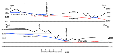
Detailed information as to the position of the shallow-water table in the Meade basin was not obtained. Since the early development of artesian water in the basin very few shallow wells have been constructed, and many of those formerly in use have been abandoned and filled. Consequently, it was impossible to measure the depth to water level in only five shallow wells in the Meade district, and one in the State Park district. Although little can be determined concerning the shape of the water table from these meager data, a few facts are known. In the northeastern part of the Meade district the water table lies 8 to 30 feet beneath the land surface, and the piezometric surface in most places is 10 to 15 feet above the water table. In the western and southern parts of the basin the difference in elevation of the two surfaces seems to increase. The relationship of the water table to the piezometric surface is shown in figure 10.
Figure 10--profiles across the artesian basin. A, North-south profile, 4 miles east of Meade. B, East-west profile, 2 miles north of Meade. See pl. 2 for locations. A larger version of this figure is available.
In the State Park district at the one well in which a shallow-water measurement was obtained, the depth to water level was 2.8 feet below the land surface, and the artesian head at the same point was 5.2 feet above the land surface.
In contrast to the piezometric surface, the shallow-water table seems to have been depressed considerably since the early settlement of the area. Residents of the area report that many shallow wells in the basin went dry before they were abandoned. Depression of the shallow-water table is also indicated by the progressive decrease of the area on which alfalfa can be grown successfully by natural subirrigation. Alfalfa was the most important crop in the Meade basin 50 years ago. The steady decline in this crop is probably attributable to the somewhat rapid lowering of the water table. The shallow-water reservoir rock has a low permeability and, as the rate of recharge is slow, the water table has seemingly not risen far, if at all, in recent years in spite of the extensive reduction in the acreage of alfalfa.
Recharge
Recharge from local precipitation--Rainfall on the surface of the basin itself and on the upper drainage basin of Crooked Creek plays an important role in recharging the shallow water of the basin. After a heavy rain, water collects in numerous shallow depressions that are scattered over the floor of the basin, and Crooked Creek and its tributaries overflow into them. Although the surficial material in most places is relatively impervious and the rate of evaporation from the shallow ponds is rapid, a small part of the precipitation percolates downward, reaching the water table.
Recharge from flowing and irrigation wells--Downward recharge by percolation of water from the surface is augmented by water discharged upon the surface by flowing wells, many of which are allowed to flow continuously throughout the year. In the irrigated areas water from deep pumped wells is spread over the surface during certain periods of the year; and, although a large part of this water is lost to the atmosphere by evaporation and transpiration, a small part of it probably reaches the water table.
Recharge by leakage through confining beds--Upward leakage through the confining beds from the artesian aquifers appears to have been the most important source of water for replenishing the shallow water in the past. It occurs as upward migration of artesian water through the sediments themselves and through fractures, minor faults, and openings produced by drilling. Such recharge has not been sufficient to maintain the water table at the surface of the ground owing to the high friction of flow through such restricted passage ways, and the large natural discharge from the shallow water reservoir.
Discharge
Discharge by transpiration and evaporation--At least since the settlement of the area, transpiration by plants and direct evaporation probably have accounted for a large part of the discharge from the shallow water reservoir. Most ordinary grasses and field crops obtain water for their growth from the upper few feet of soil (Meinzer, 1923a, p. 26). Corn, wheat, and barley probably do not use water from depths of more than seven feet. Alfalfa, on the other hand, develops roots that may penetrate 30 feet or, locally, even much greater depths in order to reach the water table. It is reported that in the early years of settlement alfalfa was raised over the Meade basin generally, but during the last 40 or 50 years production has declined sharply.
Discharge from wells--Withdrawal of water by wells from the shallow water-bearing beds is quantitatively insignificant now, and probably it has never been very great. A few stock and domestic wells account for the total withdrawal of water by this means.
Seepage into streams--The part of the total shallow water discharge, not accounted for by transpiration, evaporation, and pumpage from wells, passes as seepage into the surface streams of the area. The total quantity of water thus contributed to the surface streams is not known, but it was formerly larger than it is now. The small amount of seepage into surface streams in 1939 is indicated by the fact that parts of Crooked Creek in the Meade basin are dry during part of the year. North of Fowler several fields along the valley flat of Crooked Creek have been equipped with tile drainage pipes, the discharge of collected water systems emptying into the creek. The quantity of this induced seepage ranges within wide limits seasonally, but it rarely stops entirely.
Prev Page--Artesian Water || Next Page--Recovery
Kansas Geological Survey, Geologic History of Kansas
Comments to webadmin@kgs.ku.edu
Web version February 2004. Original publication date Dec. 1942.
URL=http://www.kgs.ku.edu/General/Geology/Meade/08_shallow.html