![]()
Prev Page--Geology || Next Page--Artesian Water
General Features of Ground Water
Source
Ground water, or underground water, is the water that issues from springs or flowing wells or can be pumped from nonflowing wells. In southwestern Kansas ground water is derived almost entirely from precipitation in the form of snow or rain. Part of the water that falls as snow or rain is carried away to the Gulf of Mexico by the streams; part of it percolates downward into the rocks until it reaches the water table where it joins the body of ground water known as the zone of saturation; and part of it may evaporate or be absorbed and transpired by the vegetation and thus returned directly to the atmosphere.
The ground water percolates slowly through the rocks in directions determined by the topography and geologic structure, until eventually it is discharged through springs or wells, through seeps directly into streams, or by evaporation and transpiration in lowlands bordering the streams. In some parts of the United States, the water has traveled many miles from the area of intake, but in Meade County water derived from shallow wells and gravity springs generally is derived from precipitation in the immediate vicinity, and the water obtained from artesian wells and springs is derived from precipitation in near-by areas to the west and northwest.
Many of the residents of this county fallaciously attribute the source of the water in their artesian wells and springs to melting snows in the Rocky Mountain region, or underflow from the Arkansas river in the vicinity of Cimarron, Kansas. It is true that the underflow of the Arkansas supplies many wells on the flood plain of that river but water moving down that valley probably does not move south under the divide to the Meade basin.
Some of the residents of the county may not believe that the amount of water falling as rain or snow is sufficient to supply the large underground reservoirs. However one inch of water falling on one square mile amounts to 17,378,720 gallons, and the average annual precipitation in the county is about 18 inches, or approximately 313,000,000 gallons to the square mile. Part of this water reaches the underground reservoir, as described above.
Principles of Occurrence
The rocks forming the outer crust of the earth are generally not entirely solid but contain numerous openings, called voids or interstices, which may contain either liquid or gas, such as water, oil, natural gas, or air. There are many kinds of rocks, and they differ in the number, size, shape, and arrangement of their interstices and hence in the amount of water they are able to hold. The occurrence of ground water in any region is therefore determined by the geology. A detailed treatment of the occurrence of ground water is given by Meinzer (1923) and a shorter treatment referring especially to Kansas has been published by Moore (1940).
The amount of water that can be stored in any rock depends on the porosity of the rock, commonly expressed as the percentage of the total volume of the rock that is occupied by interstices. A rock is said to be saturated when all its interstices are filled with water. Porosity, however, determines only how much water a given rock can hold, not how much it may yield to wells. The permeability of a rock may be defined as its capacity for transmitting water or other fluid under pressure and is measured by the rate at which it will transmit water through a given cross section under a given difference of pressure per unit of distance. A bed of silt or clay may have as high a porosity as a bed of coarse sand, but because of the small size of its interstices it may require the application of great pressure to transmit water; hence, under ordinary hydraulic gradients it may be entirely impermeable. Not all the water in a saturated rock is available to wells, because part of the water is held against the force of gravity by molecular attraction. In a fine-grained rock the molecular attraction is very great and only a small part of the water can be drained out by the force of gravity; whereas, in a coarse sand or gravel having the same porosity, only a small part of the water is retained by molecular attraction and the remainder becomes available to wells.
Gravel and sand are among the most productive water-bearing materials. It is from material of this type that all the water of the Meade artesian basin and much of the nonartesian water in adjacent parts of the county is obtained. As stated, the Tertiary and Quaternary deposits of the county were laid down by streams. As the streams built up the surface over which they flowed, they probably migrated from side to side, so that at any one locality well sorted sand or gravel may alternate with finer, less permeable materials. Thus, the unconsolidated deposits in the area consist principally of layers of fine particles of low permeability that enclose "pipes" and discontinuous sheets of permeable gravel or sand, which serve as arteries of ground water. In much of Meade County wells drilled to a depth of 200 feet or more encounter at least two, and probably more, such water-bearing beds.
The Water Table and Movement of Ground Water
The permeable rocks that lie below a certain level in Meade County and elsewhere are generally saturated with water. These saturated rocks are said to be in the zone of saturation, and the upper surface of the zone of saturation is called the water table. Of the water that falls on the soil some runs off as surface water, some is used by plants or evaporates, and the remainder is slowly drawn down by gravity through the zone of aeration to the zone of saturation, except for a small part that is retained in the pore spaces by molecular attraction. In fine-grained material the earth is always moist several feet above the water table, due to capillarity, and this moist belt is called the capillary fringe. The water retained in the capillary fringe is not available to wells, which must be sunk to the water table before water enters them.
In areas where water is confined under pressure and rises in wells above the level of the local water table, water is referred to as artesian and the wells are called artesian wells. In such wells the water level does not represent the water table but is a point on an imaginary surface called the "pressure indicating surface" or "piezometric surface."
Shape and Slope
The water table is not a static, level surface, but rather it is generally a sloping surface that shows many irregularities caused by differences in permeability of the water-bearing materials or by unequal additions of water to the ground-water reservoir at different places.
The shape and slope of the water table in Meade County are shown on the map, plate 1, by means of contour lines drawn on the water table (or piezometric surface). Each point on the water table along a given contour line has the same altitude. These water-table contours show the configuration of the water surface just as contours on a topographic map show the configuration of the land surface. The direction of movement of the ground water is at right angles to these contour lines--in the direction of the greatest slope.
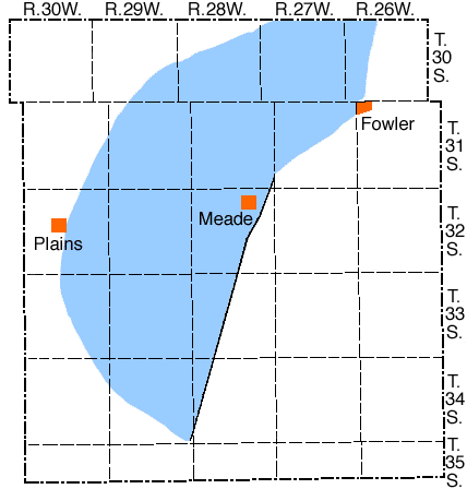
The map shows that the water under the plains moves through the county in a generally southeasterly direction, but that the direction of movement and the slope varies considerably in different places. In discussing the shape and slope of the water table and piezometric surface the county may be divided roughly into two parts, namely the area hachured in figure 5, within which artesian conditions prevail, and the remainder of the county in which watertable conditions prevail. East and south of the city of Meade these two areas are sharply distinguished by the Crooked Creek fault which is reflected in the contours by a vertical displacement of the water surface of as much as 40 feet in some places. North, south, and west of the hachured area, however, the piezometric surface merges gradually with the water table and no sharp boundary line is apparent.
Figure 5--Map of Meade Conty showing by blue shading the area in which artesian conditions prevail.
The regional slope of the piezometric surface is toward the east-southeast, and ranges from 5 to 8 feet to the mile in the northwestern part of the county to 35 feet to the mile in the central part. Along the Cimarron valley near the Oklahoma State line the regional slope is interrupted and the piezometric surface dips steeply down to the level of the valley floor. General indentations in the contour lines northeast of Meade seem to indicate cones of depression, or areas of pressure release, in localities having many flowing wells. The 2,430-foot contour clearly shows such a feature at the city of Meade. Southeast of Meade County State Park an up-dip warping of the contour lines probably indicates some lowering of the piezometric surface resulting from the discharge of considerable water from artesian springs in the park.
Northeast of Fowler the contours are flexed southward under an area of sand dunes. Water-table conditions exist under the sand dunes just south of the Fowler fault. Although there is no sharp break in slope along the fault line, it may be more distinct than the available data indicate.
The shape of the water table in the eastern and southeastern parts of the county shows a general conformity to the major topographic features. A dome in the south-central part of the county seemingly results from the exceptionally good recharge facilities in the area of sand dunes, and two smaller domes in the southeastern corner and the nose in the east-central part seem to be the result of equally good recharge facilities in filled sink holes. The nose in the east-central part of the county probably would have appeared as a dome prior to the capture of the drainage of this sink by Sand creek.
Slopes on the water table in the eastern part of the county range from less than 5 feet to the mile to more than 50 feet to the mile. The steeper gradients generally prevail in areas in which the water is moving through the Permian redbeds, which have low permeability and low specific yield.
In general the direction of movement, of ground water throughout the county is from northwest to southeast. In the southern and eastern parts of the county, however, there are many local deviations from this regional direction of movement that are controlled mainly by the topography. Some of these deviations are discussed below.
Relation to Topography
On the map, plate 2, are shown the depths to water level in Meade County by the use of isobath lines--lines of equal depth to water level. In preparing this map the more general irregularities of the surface topography were taken into account by using areal photographs and the available topographic maps. As shown on this map, the depth to water level ranges from more than 200 feet below the surface to a few feet above the land surface in the flowing well areas. Some inaccuracy has been introduced by small local irregularities on the land surface that are net shown on the topographic maps or areal photographs.
In general, the shape of the water table conforms closely to the broad features of the topography. Cimarron River and Sand and Crooked Creeks are entrenched below the level of the adjacent water table, as indicated by the upstream flexures of the contours, hence these streams are receiving water from springs and seepage along their courses. Between Meade and Fowler, however, Crooked Creek flows across the artesian basin where, as shown by the map, the course of the stream bears no relation to the shape of the piezometric surface.
Other things being equal, the slope of the water table in any area varies inversely with the permeability of the water-bearing material; that is, the water assumes a steeper gradient in flowing through fine material than through coarse, permeable material providing the same quantity of water is moving through both types of material. This probably explains at least in part the differences in the slope of the water table in different parts of Meade County. Thus, most of the steep slopes in the southeastern part of the county occur in areas in which the water is moving through the Permian redbeds, which have relatively low permeability.
Fluctuations of the Water Table
The water table does not remain in a stationary position but fluctuates up and down much like the water in a surface reservoir. If the inflow to the underground reservoir exceeds the draft the water table will rise; conversely, if the draft exceeds the inflow the water table will decline. Thus the rate and magnitude of fluctuation of the water table depends upon the rate and magnitude at which the underground reservoir is replenished or depleted.
The factors controlling the rise of the water table in Meade County are the amount of rainfall within the county that passes through the soil and descends to the water table, the amount of seepage that reaches the underground reservoir from surface streams, and the amount of water entering the county beneath the surface from areas to the west and northwest. All of these factors depend upon precipitation either in or near the county.
The factors controlling the decline of the water table are the amount of water pumped from wells, the amount of water absorbed directly from the water table by plants (transpiration), the amount of water lost from the ground-water reservoir by evaporation, the loss of water from springs, and the amount of ground water passing beneath the surface into adjacent areas.
Fluctuations caused by precipitation--The relation between the amount of precipitation and the level at which the water stands in wells is complicated by several factors. After a long dry spell the soil moisture becomes depleted through evaporation and transpiration, and, when a rain does occur, the soil moisture must first be replenished before any water can descend to the water table. During the winter when the ground is frozen the water falling on the surface is hindered from reaching the water table, and during the hot summer some of the water that falls as rain is lost directly into the air by evaporation. Where the water table stands comparatively far below the surface, as it does in part of Meade County, it fluctuates less in response to precipitation than where the water table is comparatively shallow.
The response of water levels to rainfall in an area of shallow, unconfined ground water is relatively fast if the surficial material is sufficiently pervious to allow rapid downward percolation of water, but in areas of deep water where a considerable thickness of material occurs above the water table there is generally considerable lag between the precipitation and the rise in water level, and the rise in water level generally is more gradual and of less magnitude. In artesian areas, where the water migrates laterally several miles from the recharge area, the lag in time is even more pronounced.
Changes in the water levels in wells record the fluctuations of the water table or piezometric surface, which in turn record the recharge and discharge of the ground-water reservoir. In order to determine the character and magnitude of water-level fluctuations in Meade County, 28 wells were selected for observation and periodic measurement of the depth to water levels in them were begun in July 1939. Measurements in 27 of the wells were made by me during the period July to October, 1939, and August and September, 1940, by Richard B. Christy during the period November, 1939, to April, 1941, and by Woodrow W. Wilson after April, 1941. In addition, one well (37) equipped with an automatic water-stage recorder has been observed weekly by Christopher Sobba. Complete records for these wells are published annually by the Federal Geological Survey (Meinzer and Wenzel, 1941, 1941a). The numbers of the observation wells previously published and the numbers used in this report are given in table 3.
Table 3--Observation wells in Meade County.
| Well No. in this report | Well No. in Meinzer and Wenzel, 1941, 1942. | Well No. in this report | Well No. in Meinzer and Wenzel, 1941, 1942. | |
| 7 | 11 | 220 | 40 | |
| 9 | 2 | 236 | 36 | |
| 12 | 27 | 238 | 77 | |
| 17 | 23 | 275 | 37 | |
| 24 | 3 | 278 | 33 | |
| 28 | 47 | 285 | 34 | |
| 37 | 234 | 297 | 10 | |
| 66 | 45 | 308 | 59 | |
| 100 | 55 | 313 | 16 | |
| 109 | 42 | 317 | 57 | |
| 114 | 41 | 322 | 101 | |
| 118 | 62 | 331 | 76 | |
| 173 | 61 | 332 | 73 | |
| 193 | 88 | 342 | 304 |
The fluctuations of the water level in five typical observation wells in Meade County during the period of record and the precipitation at Plains are shown in figure 6.
Figure 6--Hydrographs of five typical observation wells in Meade County and the monthly precipitation at Plains (precipitation data from U.S. Weather Bureau).
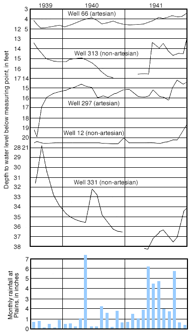
With reference to figure 6, it will be noted that none of the wells show a close correlation between the rainfall at Plains and the water level. The water level in well 331 shows marked rises during the summer of 1940 and during the summer and fall of 1941 that coincide with periods of heavy rainfall, but the highest water level during the period of record occurred in the fall of 1939 when only a small amount of rain fell at Plains. This may be explained by the fact that this well is located in a small drainage basin, about 20 miles from Plains, and so the water level may have risen in response to local rainfall that was not recorded at Plains. The only other well that shows any apparent correlation between rainfall and water level is 313. The water level in this well rose sharply during May 1941, in response to a period of above-normal rainfall.
Wells 66 and 297 are artesian and show no apparent relation of water level fluctuations to rainfall during the brief period of record. Well 297 is pumped for irrigation during part of the year and the fluctuations in water level shown in figure 6 probably are due to pumping.
Although well 12 is nonartesian it has had no significant fluctuations in water level during the period of record. This may be accounted for by the facts that it is situated in fine-grained sediments, and that several near-by deep irrigation wells may have supplied some artificial recharge during the periods of deficient rainfall.
Fluctuations caused by pumping--If a well is heavily pumped the water levels in wells several hundred feet or even a few miles away may be lowered somewhat. After pumping of the well has ceased, the dewatered volume of sediments slowly refills with water and the water level in the well gradually recovers to approximately its former position.
Under artesian conditions the development of the cone of depression (see principles of recovery) and the effect on the water levels in near-by wells take place much more rapidly and are effective over a much larger area than under water-table conditions. As there generally is no dewatering of the water-bearing formation, the recovery under artesian conditions is more rapid than under water-table conditions. The effect of pumping on the piezometric surface is discussed under artesian water and drawdown and recovery curves in the artesian area are shown in figures 8 and 9.
Recharge
Recharge is the addition of water to the underground reservoir and may be accomplished in many different ways. The ground water within practicable drilling depths in Meade County is derived principally from precipitation that falls as rain or snow within the county or on areas to the west of the county. In Meade County there is also some recharge by influent seepage from streams and by subsurface inflow from areas to the west of the county. The latter source of recharge is discussed under Artesian Water.
Recharge from Local Precipitation
As pointed out above, the primary source of ground water in Meade County is rain or snow that falls on this or adjacent areas. It is a difficult problem, however, to determine with certainty the percentage of the water falling on the area that eventually reaches the water table. The Kingsdown silt, which underlies much of the High Plains part of the county, is relatively impervious and so serves to retard or prevent the downward percolation of water. Many shallow, undrained depressions on this surface catch and hold rain water and prevent surface runoff. The fact that these shallow depressions, many of which are 150 feet or more above the water table, are occupied by shallow ponds for weeks or even months after a heavy rain seems to indicate that. even in these areas the water percolates downward so slowly that most of it evaporates before it has an opportunity of entering the ground. Recent studies of recharge from similar shallow depressions in the High Plains of Texas (White, Broadhurst, and Lang, 1940, pp. 6-8) indicated that recharge from some ponds was quite rapid; whereas, in others, it was slow or nonexistent. The problems of the two areas are not entirely similar, as in the Texas area beds of caliche locally prevent downward movement of water; whereas, in Meade County, caliche does not seem to be effective in this respect, but the same purpose is served by homogeneous deposits of silt. Probably none of the recharge areas in Meade County are as effective as some of the more favorable areas in Texas. On the other hand, however, probably none of the depression ponds in Meade County are as completely scaled off as are some of the ponds studied in Texas.
Rodent burrows and sod cracks probably are important avenues of access for rain water entering the ground. During dry seasons, in certain grassland areas of the High Plains, there may be observed extensive sod cracks in the typical polygonal pattern of flood-plain mud cracks, extending over areas several square miles in extent. Some cracks of more than an inch in width have been observed and have been prodded to depths of nearly four feet.
Sand dunes, such as occur in the southern, southwestern and northeastern parts of the county, are probably effective aids to recharge. The dune sand is quite porous and very little surface drainage has developed in these areas. Rain water enters the sand and generally percolates downward freely. In places where the permeability of the underlying material may not be high, water from recharge is held in the dune sand for a considerable period and at least a part of the water may in time penetrate the underlying material.
Rain that falls on the alluvium along the streams is probably much more effective in recharging the ground-water reservoir than rain falling on the High Plains; however, the total area of alluvium, as shown in plate 1, is relatively small.
Recharge from Streams
It is probably true that during periods of maximum flow in the major streams of the county some water leaves the channels and moves into the adjacent channel and flood plain deposits. This type of recharge is not very effective in this county. The minor intermittent tributaries that lie above the water table have such steep gradients that they contain water only for very short periods of time after rainstorms. At such times, however, the water is moving very swiftly and is heavily laden with sediment, hence there is very little opportunity for water to percolate downward. Thus it appears that very little recharge from streams takes place in Meade County.Discharge
Natural Discharge at the Surface
Before any wells were drilled the ground-water reservoirs of Meade County were in a state of approximate equilibrium. The average annual recharge was balanced by an approximately equal average annual discharge. The greater part of the natural discharge occurred through springs and seeps along the valleys of Crooked Creek and Cimarron River. A part of the water was discharged by direct evaporation and by transpiration from trees, grasses and shrubs in shallow water areas, a very small amount was lost as evaporation from water-table lakes, and the remainder passed southeastward beneath the surface into adjacent areas.
A large percentage of this discharge occurred through artesian springs along Crooked Creek and its tributaries, and as seepage into streams from the shallow ground-water body in the Meade basin, as discussed in subsequent chapters. In addition a small quantity of water is discharged from gravity springs along the Cimarron valley. Most of the water issues from sand and gravel overlying beds of clay and silt in the Ogallala and Meade formations, but in the southeastern part of the county the water issues from the basal Tertiary deposits which overlie less permeable Permian redbeds.
Little or no water is discharged by transpiration and evaporation in the High Plains area, as the water table lies more than 100 feet below the surface under this entire area (Pl. 2). These processes are operative along the valleys of permanent streams, however, and in the shallow water area northeast of the city of Meade. That area constitutes a more or less special problem which is discussed in a subsequent section.
Discharge from Wells
At the present time wells constitute one of the principal means of discharge of ground water within the county. Discharge from wells occurs both as natural flow at the surface from flowing artesian wells and by pumping from nonflowing wells. Most of the well discharge occurs in the artesian basin and immediately adjacent uplands, and is discussed in a later chapter. Outside of that area only small quantities are pumped from wells for domestic and stock supplies. There is only one large irrigation well (272) and one large municipal well (269) on the High Plains in Meade County.
Prev Page--Geology || Next Page--Artesian Water
Kansas Geological Survey, Geologic History of Kansas
Comments to webadmin@kgs.ku.edu
Web version February 2004. Original publication date Dec. 1942.
URL=http://www.kgs.ku.edu/General/Geology/Meade/06_gw.html