![]()
Prev Page--Quality || Next Page--References
Water-bearing Formations
Physical Properties of Water-bearing Materials
Samples of material penetrated by the rotary drilling machine were collected and dried in the field by Perry McNally. When dry, the samples were sacked and taken to the laboratory of the Geological Survey at Lawrence, where they were studied with a binocular microscope. Mechanical analyses and determinations of the coefficient of permeability of selected samples were made by Charles C. Williams. These data are given in table 9.
The samples collected from the test holes were washed to the surface by the drilling mud and, therefore, cannot be regarded as truly representative of the materials as they occur undisturbed in nature. An effort was made to use mud as light as possible. The light mud may have removed some of the finer particles that occur naturally in the sands and gravels. On the other hand, very heavy mud was used in some of the test holes, particularly in the artesian basin, with the result that the samples are believed to contain more mud than they should. Despite these difficulties in sampling, it is believed that the laboratory determinations gave reasonably correct answers, and that the data are sufficiently accurate for comparing the water-bearing character of the several formations.
A mechanical analysis of granular material consists in separating into groups the grains of different sizes and determining what percentage, by weight, each group constitutes. The dried samples were placed in a large mortar and adhering lumps of material gently broken up. Representative samples of the desired size were obtained by repeated quartering. Carefully weighed samples that averaged 75 grams each were put into a set of standard a-inch screens; the screens were shaken vigorously for 25 minutes in a rotary shaker; and the fractions were weighed on a precision balance.
The permeability of a water-bearing material is its capacity for transmitting water under pressure. The coefficient of permeability, as determined in the field or laboratory, is expressed by O.E. Meinzer as the number of gallons of water a day at 60° F., that is conducted laterally through each mile of the water-bearing bed under investigation (measured at right angles to the direction of flow), for each foot of thickness of the bed, and for each foot per mile of hydraulic gradient (Stearns, 1927, p. 148). The coefficients of permeability given in table 9 were determined by means of a portable field apparatus designed by V. C. Fishel and V. T. Stringfield of the Federal Geological Survey.
The figures given in table 9 indicate that the character and permeability of the several water-bearing formations range between somewhat wide limits. More than 60 percent of the samples analyzed had a coefficient of permeability of more than 100, and two samples had coefficients of more than 1,000.
Permian System
General Features
The oldest rocks exposed in Meade County are of Permian age. They consist of red sandstone, siltstone, and shale, with occasional beds of gray shale and thin beds of gypsum. Permian rocks are known to contain beds of salt and gypsum at a depth of only a few hundred feet below the surface. These beds, which constitute the uppermost Permian strata in Kansas, have been referred by Norton (1939, pp. 1813, 1814) to the Big Basin formation, but are classed by the Kansas Geological Survey as belonging to the Taloga formation (Cragin, 1897, p. 362). Some slightly older beds belonging to the Whitehorse group (as used by the Kansas Geological Survey) may be exposed in Meade County.
With the exception of a few small exposures along crooked creek valley south of Meade, Permian rocks crop out only in the southeastern part of the county. The total thickness exposed in this county is somewhat more than 100 feet.
Water Supply
In the southeastern part of the county small supplies of very hard water are obtained from the Permian rocks. Domestic and stock wells penetrate these rocks only to relatively shallow depths, and it is possible that somewhat larger supplies might be obtainable by drilling deeper wells. At a depth of only a few hundred feet or less, however, the chloride content of the Permian water becomes so high as to make it unfit for use. An analysis of a sample of water from the Permian redbeds is shown in figure 11.
Cretaceous System
General Features
Cretaceous rocks have nowhere been observed cropping out in Meade County. Cretaceous strata have been encountered underlying the Tertiary deposits in several test holes. The thickest beds of Cretaceous rock occur in the northeastern and southwestern parts of the county. In the vicinity of Fowler there occurs more than 200 feet of Cretaceous beds, consisting dominantly of black and blue-gray shale, which is probably equivalent, at least in part, to the Kiowa shale of Clark and Kiowa counties. In southwestern Meade County the Cretaceous deposits attain a maximum thickness of approximately 300 feet, consist dominantly of sand, and contain a few beds of shale. The thick sand may be an equivalent of the Cheyenne sandstone which is known to crop out to the east, or of the Cockrum sandstone, described by Latta (1941) from exposures to the west of this area, or these deposits may contain equivalents of all or most of the pre-Graneros Cretaceous beds, and possibly also some overlying beds.
Water Supply
The Cretaceous water-bearing beds have not as yet been tapped by water wells in Meade County. The quality of water obtainable from these beds can be judged only by the quality of water obtained from equivalent deposits in adjacent areas. It is probably a safe assumption that water from the Cretaceous rocks will be of satisfactory quality for most uses, although it may be somewhat harder than the waters obtained from the Tertiary deposits in the same vicinity. Judging from the thickness and permeability of these beds in southwestern Meade County, they contain an extensive, reserve supply of ground water which might become important if the supply obtainable from the overlying Tertiary deposits should ever prove inadequate, and if the greater depth of drilling necessary to obtain water from the Cretaceous deposits becomes economically feasible.
Tertiary System
Laverne Formation
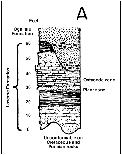
Character--The Laverne formation was named and described from a locality in Harper county, Oklahoma, by V. V. Waite in an unpublished manuscript later quoted by Gould and Lonsdale (1926). The deposits constituting this formation consist of gray, fine-grained, thin-bedded sandstone, some of which contains conglomerate; blue-gray to tan, even-bedded shale, and tan, soft, silty limestone, which typically includes a thin bed of gray dense limestone at the top. The soft silty limestone can be cut with a saw and has been quarried for building stone and used in the construction of ranch buildings in the Cimarron valley. A generalized section of the Laverne formation is given in figure 12A. A section of the Laverne measured near the mouth of Wolf canyon, on the south side of the Cimarron valley, is given below.
Figure 12a--Generalized section of the Laverne formation in Meade and Seward counties, Kansas.
| Section of Laverne formation, sec. 7, T. 35 S., R. 30 W. | Thickness, feet |
|
|---|---|---|
| 3. | Silt, clay and fine sand, highly calcareous, tan and gray in color. Some beds are chalky, even-bedded, and weather to a punky, friable surface. This rock has been quarried for building purposes and is locally referred to as "saw rock" | 15.6 |
| 2. | Shale, containing some fine sand, thin bedded, brown, gray, red and tan in color | 11.4 |
| 1. | Sand, fine, tan-brown, thin bedded and well indurated. Weathers to loose sand. The bottom of the interval is partly covered | 12.8 |
| Total thickness exposed | 39.8 | |
As stated in an earlier report (Frye and Hibbard, 1941, p. 398-401) these beds should be considered a distinct formation rather than a member or zone of the Ogallala formation, as suggested by Hesse (Chaney and Elias, 1936, p. 51), because: (1) The nonconformity that separates the Laverne from the Ogallala is the greatest break in sedimentation recorded in the Pliocene and Pleistocene section. The beds of the Laverne dip at angles as great as 15 degrees and are overlain by horizontal beds of the Ogallala. (2) The lithology of the Laverne is distinct from that of the overlying Ogallala; in fact, on casual inspection these beds more closely resemble the underlying Cretaceous rocks than they do the Ogallala. (3) It is a unit that is easily recognizable and mapable in the field.
Distribution, thickness, and surface form--The Laverne formation is exposed only in the southwestern corner of the county along the bluffs of the Cimarron valley and small tributary canyons. Sixty feet of Laverne strata are exposed in Meade County, but the base has nowhere been observed. The maximum thickness of this formation in Kansas may exceed 100 feet. It consists mostly of relatively resistant rocks, and steep slopes are developed on its outcrops. Near the Meade-Seward county line hard limestone beds of the Laverne dip below the floor of the Cimarron valley and have caused a noticeable constriction of the valley.
Age and correlation--These deposits are correlated with the Laverne formation of Oklahoma on the basis of their lithology, fossil content, and stratigraphic position. As stated in an earlier paper (Frye and Hibbard, 1941, p. 403):
The position of the Laverne formation unconformably below middle Pliocene deposits, and the presence of lower Pliocene fossils in the upper part of the formation, date it as lower Pliocene, and the lower part possibly is upper Miocene in age.
Water supply--To date there has been only one water well drilled into the Laverne of Meade County. The area of outcrop is in a sparsely populated part of the county, and occurs along the sides of the Cimarron valley, which contains water-bearing alluvium. The character of the Laverne formation suggests that supplies sufficient for domestic or stock use could be obtained from it if additional water should ever be needed in this area.
Ogallala Formation
Character and subdivisions--The Ogallala formation was named by Darton in 1899 (pp. 734, 735, 741, 742, pl. 84) from a locality in southwestern Nebraska. In 1920 Darton (p. 6) referred to the type locality as near Ogallala station in western Nebraska. Smith (1940, pp. 39-94) has recently reviewed the literature dealing with the Ogallala and has discussed its occurrence in southwestern Kansas.
The Ogallala formation consists of clay, silt, sandy silt, caliche, and cross-bedded sand and gravel (pl. 11B) which locally is cemented by calcium carbonate to a hard, "mortar bed" type of rock. A generalized section of the Ogallala formation is shown in figure 12B. Channel sands and gravels typically occur at the base and are quite variable laterally. At many localities the top of the middle Pliocene part of the Ogallala is marked by a hard bed of caliche, or limestone, which locally is silicified. The bulk of the formation consists of massive sandy silt, pink or tan in color, interbedded with sand, gravel, and caliche. A section of the Ogallala formation measured along Wolf canyon follows:
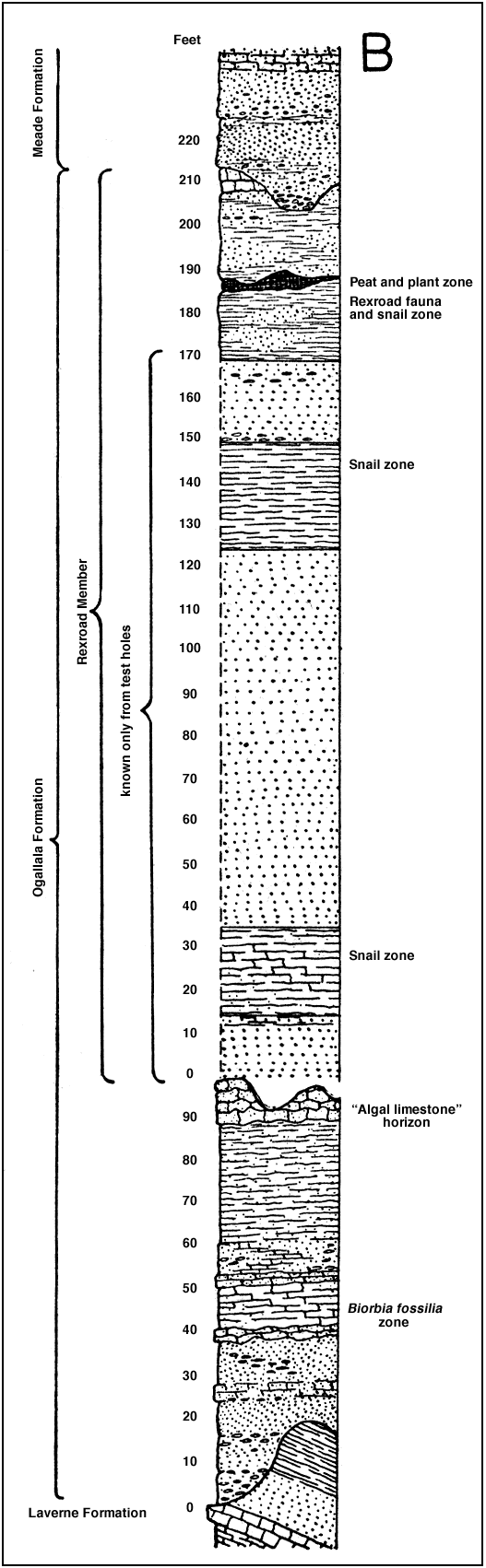
Figure 12b--Generalized section of the Ogallala formation in Meade County. The positions of the "algal limestone" horizon, a zone of abundant Biorbia fossilia, the Rexroad fauna, and several snail zones are shown. This is a composite section and it should be noted that in those localities in which the middle Pliocene part is well exposed the Rexroad member typically is thin or absent.
| Section of Ogallala formation, sec. 7, T. 35 S., R. 30 W. | Thickness, feet |
|
|---|---|---|
| 11. | Sand and gravel, tan to red-brown, locally capped by a thin bed of caliche | 12.0 |
| 10. | Caliche, ash-gray, contains sonic sand, dense, hard. Weathers to a vertical nodular face | 6.5 |
| 9. | Silt, sand, and clay, contains a few nodules of caliche, pink, gray, and light tan | 21.0 |
| 8. | Sand and gravel, cross-bedded at base, massive at top. Weathers to a nodular surface | 14.4 |
| 7. | Silt, sand, and clay, buff-tan, loose, massive | 6.5 |
| 6. | Sand, gray and tan, loose | 6.0 |
| 5. | Silt, sand, and clay, pink, tan, and huff, blocky, massive, contains some caliche | 13.5 |
| 4. | Caliche contains some sand and silt, gray. Weathers to a nodular surface | 2 .0 |
| 3. | Silt, sand, and clay, red, tan and gray, partly covered | 10.0 |
| 2. | Sand and gravel, cross-bedded, partly cemented | 47.2 |
| 1. | Covered. The Laverne formation occurs below this interval | 14.0 |
| Total thickness | 153.1 | |
A typical section of the middle Pliocene part of the Ogallala formation and the overlying Meade formation occurs along Crooked Creek valley, south of Meade, and is given below:
| Section of Meade and Ogallala formations, NW1/4 sec. 12, T. 33 S., R. 28 W. | Thickness, feet |
|
|---|---|---|
| Meade formation | ||
| 18. | Silt, sand, and some clay, tan to buff-brown, massive. Contains sandy beds and caliche beds. The surface at the top of the bluff is covered with a rubble of caliche cobbles | 14.8 |
| 17. | Sand and silt, gray to gray-tan | 5.4 |
| 16. | Clay, with some silt and sand, light gray, massive. Breaks with a conchoidal fracture when dry | 4.5 |
| 15. | Volcanic ash, pearl gray, lenticular, somewhat impure | 1.6 |
| 14. | Silt, clay, and some sand, gray, massive, contains a few calcareous nodules | 6.4 |
| 13. | Volcanic ash, pearl gray, thin bedded and cross-bedded | 7.1 |
| 12. | Clay, silt, and some sand, tan-gray and brown-gray, massive. Grades upward into yellowish gray-green sand and contains some mottled, yellow-brown silt. Contains a few thin beds of ash and calcareous nodules | 9.5 |
| 11. | Sand, silt, and coarse gravel, brown, contains abundant nodules. Grades upward into red-brown to tan-maroon sand and silt | 8.8 |
| 10. | Sand, coarse and well sorted at base, grading upward into finer more poorly sorted sand. Calcareous nodules at top | 10.1 |
| Total thickness of Meade formation exposed | 68.2 | |
| Ogallala formation | ||
| 9. | Caliche, sandy, gray-tan | 0.4 |
| 8. | Silt, fine sand, and some clay, tan to huff, massive | 1.6 |
| 7. | Sand, fine, and some silt, yellow-tan, thin bedded | 1.0 |
| 6. | Sand and silt, reddish-tan, massive | 4.0 |
| 5. | Unexposed | 2.9 |
| 4. | Caliche, sandy, nodular, massive, vertical nodular stringers of caliche and pockets and lenses of pink-tan sandy silt | 11.2 |
| 3. | Sand, silt, and clay, pink-tan. Contains some nodular bands of caliche and some gravel | 6.1 |
| 2. | Sand and gravel, cross-bedded, Contains both tightly cemented and loose zones. The gravel is quite coarse in some beds and contains blocks of red Permian siltstone. Becomes coarser and more poorly sorted upward, and a "mortar bed" occurs at the top | 34.6 |
| 1. | Unexposed. A near-by test hole shows this interval to be occupied by sand and gravel overlying Permian redbeds | 11.2 |
| Total thickness of Ogallala formation | 78.0 | |
The Ogallala formation in Meade County has been classified (Frye and Hibbard, 1941, p. 399) as consisting of a middle Pliocene member (unnamed) and the upper Pliocene Rexroad member.
Rexroad member--In 1940 the upper Pliocene beds of central Meade County were named the Rexroad formation by Smith (1940, p. 95) from exposures along a tributary to Crooked Creek on the Rexroad ranch, in the same general locality from which the Rexroad fauna was collected by Hibbard (1938). More recently these beds have been included as the Rexroad member of the Ogallala formation for the following reasons (Frye and Hibbard, 1941, p.407):
(1) On the basis of both surface and subsurface data, it seems evident that in parts of the basin there was continuous sedimentation from middle Pliocene through upper Pliocene time, and in those localities no break is distinguishable; (2) the deposits were trapped in a local basin, and, although there are deposits of equivalent age outside this general area, they are not stratigraphically continuous with the deposits of the Rexroad type locality, and are not genetically related to them; and (3) as Smith (1940, pp. 95-97) has pointed out, the lithology of the Rexroad beds for the most part is indistinguishable from the middle Pliocene part of the Ogallala formation. For these reasons the Rexroad beds do not constitute a mapable unit, except partially in the vicinity of the type locality, where the upper contact, but not the lower, can be mapped.
The lower and thicker part of the Rexroad member does not crop out at the surface in Meade County, so that the thickness and character of the member are known only from test-hole samples and well logs. Where the entire member is present it is about 200 feet thick, but in the deepest part of the basin it may attain a maximum thickness of 250 feet, and east of the Crooked Creek fault it is only about 30 feet thick. On the basis of data from test holes, the lower 175 feet of the Rexroad member may be described as comprising alternating beds of sand, silt, and clay. The thickness of individual beds ranges considerably. Two well-defined snail zones were encountered in the test drilling, and the fossils, some of which were brought to the surface unbroken, have aided in the recognition of the beds.
The upper beds of the Rexroad member, which are exposed at the surface, consist of blue-gray, tan, and gray sand, silt, and clay. At many places a bed of soft sandy caliche occurs at the top of the member, and at a few localities a thin bed of peat occurs 20 to 30 feet below the top. The Rexroad member of the Ogallala formation is overlain unconformably by the basal sand or gravel of the Meade formation of Pleistocene age. A generalized section of the Rexroad member in central Meade County is shown in figure 12B.
Caliche--The prevalent occurrence of caliche in the Tertiary and Quaternary deposits of the southern High Plains has presented a puzzling problem since the early work on these beds. Caliche occurs abundantly in these deposits from Texas and New Mexico northward to Colorado and Nebraska. The earlier literature dealing with the caliche problem in Texas has been summarized by Sayre (1937, pp. 65-72) and, in western Kansas, by Smith (1940, pp. 90-92). In southwestern Kansas it has been common practice to refer to beds which contain only a small percentage of calcium carbonate as "caliche" and to use the term more or less interchangeably with "mortar bed." It is my opinion that there occur in these strata two distinct types of calcium carbonate deposits, and that the origin of the two may or may not be similar. The first type consists of irregular beds and nodular bands of chalky calcium carbonate, occurring in both coarse and fine material and transgressing various types of material. This type, to which the use of the term "caliche" is here restricted, almost invariably contains some impurities either of silt, sand, or gravel, and locally contains some chert. The other type, which, for lack of a better name, will be referred to as "mortar bed," consists of cemented zones, beds, or lenses of sand or of sand and gravel. The cementation may have been produced by percolating ground water, localized by the texture of the deposit, or it may have been produced in a manner similar to that described for caliche. Mortar beds locally occur as cemented lenses of sand within a thick sequence of sand and gravel or of fine sand and silt. The texture of the cemented bed may be either coarser or finer than that of the enclosing material.
The origin of caliche will not be discussed in detail here. However, one hypothesis that seems to fit the conditions existing in this area will be presented. During the latter part of the Pliocene and the Pleistocene, the time during which caliche was being formed in this area, the Rocky Mountain region to the west stood high above the adjacent plains and was being vigorously eroded by competent streams. The streams transporting sediments to the plains area carried in solution calcium carbonate, derived from the igneous and sedimentary rocks being eroded. In the plains region these streams were aggrading--filling their channels, which often shifted in position, and overflowing and spreading deposits over their flood plains. Although it is possible that the first effect of a cold Pleistocene climate was not felt in the Rocky Mountain region until after some caliche formation had taken place, it seems certain that the water flowing from these mountain streams was relatively cold. It is a well-known fact that cold water heavily charged with calcium carbonate will, when heated, lose part of this dissolved material. When floodwaters from these streams spread over their broad flood plains the temperature of the water must have been raised sufficiently to cause some precipitation of the dissolved lime. It is also well known that calcium carbonate will be precipitated from an aqueous solution at constant temperature if carbon dioxide is removed. It is certain that grass or other forms of vegetation covered the extensive plain of alluviation, and it is possible that the plants may be able to extract carbon dioxide from the water flooding the surface. Thus, the factors producing deposition of caliche in these sediments seem to be a rise in temperature of the waters of the depositing streams plus the possible extraction of additional carbon dioxide by vegetation. These factors probably were augmented by evaporation and concentration of the solution by drying winds and sun.
After the initial deposition of the carbonate of lime over the aggradational plain, the deposit was acted upon and modified in form by several processes. Downward percolating rainwater may have dissolved some of it and distributed it through the soil, or concentrated it in the form of nodular bands or beds at the base of the soil zone. Successive inundations by flood waters in some places probably mixed the calcium carbonate with clastic material, and in still other places there may have been an upward concentration by capillary action. It is certain that the erosional history of the region has not been such as to have allowed the concentration of calcium carbonate by a gradual erosional lowering of the upland surface, with a progressive concentration of calcium carbonate at the base of the soil profile.
The algal limestone (Elias, 1931, P. 141) or the capping limestone (Smith, 1940, p. 90) presents a special case of calcium carbonate deposition. Elias believed that in northwestern Kansas this limestone was deposited in a widespread shallow lake and that it contains algal structures; Smith, however, has presented considerable evidence against this hypothesis. In some areas it is harder than in others and contains less impurities than typical caliche, but it grades both laterally and vertically into more typical material. Chert occurs in this bed at a few localities and may have been formed by secondary silicification after the extensive deposits of volcanic ash were laid down in this area.
Distribution, thickness, and surface form--The Ogallala formation crops out over a large area in the southeastern part of the county and in smaller areas in the central and southwestern parts of the county (pl. 1). Throughout the rest of the county it underlies Pleistocene sediments except in a few places where it has been eroded completely. Its maximum thickness of more than 350 feet occurs in the structural depression west of the Crooked Creek fault, and only in this area is the Rexroad member, which here attains a maximum thickness of 250 feet, well developed. The middle Pliocene part of the Ogallala attains a maximum thickness of 125 feet and is widespread over the county. Little more than 10 feet of Ogallala beds are present. along the rims of the major valleys in parts of southeastern Meade County. In the southern and southeastern parts of the county the outcrops of the Ogallala are well indurated and have been eroded to form deep, steep sided canyons.
Age and correlation--The stratigraphic position of the Ogallala formation unconformably above the lower Pliocene beds of the Laverne formation and below the Pleistocene Meade formation, the presence of fragmentary middle Pliocene vertebrates and plant remains in the lower part of the Ogallala, and the upper Pliocene Rexroad fauna in the Rexroad member (Frye and Hibbard, 1941 pp. 408-410) date the age of the Ogallala formation in Meade County as middle and upper Pliocene. Deposits equivalent in age to the middle Pliocene part of the formation are widespread in western Kansas and adjacent states. The Rexroad member, however, apparently was deposited in response to local structural and physiographic conditions; hence, but few deposits of equivalent age are known to occur in adjacent areas.
Water supply--The sands and gravels of the Ogallala formation are the most productive sources of ground water in Meade County. More than half of the domestic and stock wells, all of the municipal wells, and most of the irrigation wells draw water from this formation.
The finer materials of the formation generally are porous and hold considerable water, but are not permeable enough to yield water freely. The coarser materials, the gravels in particular, generally yield abundant supplies of water. Mechanical analyses and coefficients of permeability of samples of sand and gravel from the Ogallala in seven test holes are given in table 9. Beds of water bearing sand and gravel may be found at almost any depth in the formation but as a rule are thicker and more permeable in the lower part. The Ogallala is especially thick and permeable in the structural depression west of the Fowler and Crooked Creek faults. All but one of the irrigation wells are situated in this part of the county and have reported yields up to 1,800 gallons a minute.
The Ogallala formation is a large underground reservoir that is only partly filled with water. In the east-central and southeastern parts of the county the Ogallala is relatively thin and lies entirely above the water table, and, therefore, will not yield water to wells. The thickness of saturated material in the Ogallala is shown in cross sections AA', BB', and CC' in figure 4. Logs of the test holes indicate that more than half of the saturated zone in the Ogallala is composed of sand and gravel, so the amount of water available is large.
Twenty-one analyses indicate that the water from the Ogallala formation is moderately hard. With few exceptions the samples contain 150 to 300 parts per million of hardness and 150 to 250 parts per million of bicarbonate. The chloride content generally is less than 25 parts per million. The content of sulphate, fluoride, and iron generally is low. Representative analyses are shown graphically in figure 11, and the 21 analyses are given in table 7.
Quaternary System
Meade Formation
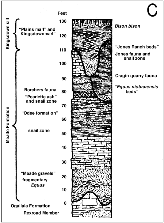
Character and subdivisions--The "Meade gravels" were named by Cragin (p. 54) in 1896 from exposures in central Meade County. Cragin's "Meade gravels" recently were redefined as the Meade formation (Frye and Hibbard, 1941, p. 411) to include all of the beds of Pleistocene age between the top of the Rexroad member of the Ogallala formation and the base of the Kingsdown silt, and this usage is continued in the present report. This formation consists of gravel, sand, silt, clay, volcanic ash, and caliche. A generalized section of the Meade formation, showing the stratigraphic position of the several previously named units and the local faunas, is given in figure 12C.
Figure 12c--Generalized section of the Meade formation and the Kingsdown silt in Meade County. The stratigraphic positions of previously named beds, local vertebrate fauna, and snail zones are shown.
A thick bed of cross-bedded sand and gravel typically occurs at the base of the formation. These beds grade laterally into finer sands and in some localities are absent. The sand and gravel locally is cemented by calcium carbonate to a hard "mortar bed" or sandstone, as shown in plate 11A, but in most places is unconsolidated. A measured section of the lower part of the Meade formation at a locality where the basal beds of sand and gravel are quite thick is given below.
| Section of Meade and Ogallala. Formations, NE 1/4 sec. 33, T. 32 S., R. 29 W. | Thickness, feet |
|
|---|---|---|
| Meade formation | ||
| 8. | Clay, silt, and sand, pink-tan and gray. Contains nodules of caliche with a tough bed of caliche at the top | 12.5 |
| 7. | Sand, fine- to medium-grained, tan-brown, contains some tilt | 5.4 |
| 6. | Sandstone, medium grained, light gray, tough | 2.0 |
| 5. | Sand, medium, gray-tan, well sorted, cross-bedded | 8.4 |
| 4. | Sand and gravel, cross-bedded. A marked disconformity occurs at the base | 36.2 |
| Total thickness of Meade formation exposed | 64.5 | |
| Ogallala formation, Rexroad member | ||
| 3. | Clay, silt, and sand, gray-tan and light dull-pink, very calcareous, massive | 6.0 |
| 2. | Silt, sand and gravel, pink-tan, contains nodules and intersecting stringers of caliche. Finer and more calcareous at the top | 26.0 |
| 1. | Clay, tilt, sand, and gravel, light cream-gray, tough when dry. Contains a few bands of caliche | 3.0 |
| Total thickness of Rexroad member exposed 35.0 | ||
The interval above the basal part of the Meade formation comprises beds of thin-bedded clay, silt, and sand, ranging in color from gray, blue-gray, and tan to dark brick red. These beds range greatly in thickness and are best developed and best exposed in the southern part of Meade County, as shown in plate 12A. A measured section of this part of the Meade formation exposed in the northern bluff of the Cimarron valley south of Meade is given below.
| Section of the Meade formation, SE sec. 34, T. 34 S., R. 29 W. | Thickness, feet |
|
|---|---|---|
| Meade formation | ||
| 21. | Soil | 3.0 |
| 20. | Silt, clay, and fine sand, medium gray, blocky. Calcareous nodules occur throughout. A purple-gray zone occurs at the base and a dark gray zone at the top | 19.3 |
| 19. | Silt, pink-tan, massive, alternating with thin-bedded sand, tan and gray | 5.2 |
| 18. | Sand, fine, with some silt, tan-cream, thin bedded | 1.2 |
| 17. | Silt, clay, and sand, tough, pink-tan, contains a few light, blue-gray streaks | 3.9 |
| 16. | Sand, fine, and silt, light cream-tan | .4 |
| 15. | Silt, fine sand, and clay, pink-tan. Contains several bands of light tan silt 0.1 foot thick | 11.5 |
| 14. | Sandstone, nodular surface, hard | .5 |
| 13. | Sand, gray and light buff, contains orange-yellow streaks, thin bedded | 2.2 |
| 12. | Silt and clay, massive, purple tan | .8 |
| 11. | Sand and silt, tan, gray, and buff, thin bedded | 2.6 |
| 10. | Silt and clay, purple-tan, blocky | .4 |
| 9. | Sand and silt, gray-tan and buff, thin bedded | .6 |
| 8. | Silt and clay, purple-tan, blocky | 1.0 |
| 7. | Sand, fine, and silt, thin bedded in some zones and massive in others, friable, tan in lower part grading upward into yellow-tan | 12.5 |
| 6. | Sand, fine, and silt, tough, massive, tan-maroon | 6.0 |
| 5. | Silt, light gray-tan to cream, contains so me clay and fine sand | .8 |
| 4. | Silt, clay and fine sand, maroon | 1.2 |
| 3. | Sand, fine and silt, pink-tan, tough | 1.2 |
| 2. | Silt and clay, contains some fine sand, massive, red-tan. Loose on weathered surface | 9.2 |
| 1. | Silt and clay, blocky, maroon, weathers to a loose surface | 20.8 |
| Total thickness exposed | 104.3 | |
It is within this varicolored zone that Smith's Odee formation occurs (Smith, 1940, pp. 100-108). The "Odee formation" has not proved to be a satisfactory unit for field mapping for the following reasons (Frye and Hibbard, 1941, p. 413):
(1) The formation, as described, has no definite top or bottom; (2) it is essentially a color zone that interfingers with and grades laterally into equivalent beds of different color; and (3) beds of similar appearance at a somewhat different stratigraphic position within the Pleistocene seemingly were trapped in isolated sink holes, and some of these beds cannot be distinguished lithologically from the "Odee" at the type locality.
A section measured near the type locality of the "Odee formation," along a tributary to crooked creek, is given below.
| Section of the Meade formation, NW SE Sec. 1, T. 34 S., R. 29 W. | Thickness, feet |
|
|---|---|---|
| 6. | Sand, containing some silt and clay, ash-gray, loose and friable. Contains some small crystals of gypsum and mollusks. Inter-bedded fine and coarse zones, thin bedded and massive | 19.8 |
| 5. | Silt, clay, and fine sand, maroon and tan (weathers to purple-gray), blocky. Contains a few crystals of gypsum and bands of blue-gray and yellow-tan clay. A zone abundant in gypsum occurs near the top | 9.2 |
| 4. | Silt and fine sand, yellow-tan, blocky, contains some small crystals of gypsum | 2.0 |
| 3. | Silt, fine sand, and clay, maroon. Contains thin beds of gray-cream fine sand | 20.7 |
| 2. | Silt, fine sand, and clay, yellow-tan, irregular bedding | 3.0 |
| 1. | Clay and silt, blue-gray | .5 |
| Total thickness exposed | 55.2 | |
In parts of the county the beds described above are overlain by a bed of volcanic ash, which was named the Pearlette ash by Cragin (1896, pp. 53, 54). This ash bed attains a thickness locally of 12 to 14 feet, and has been mined extensively in the county for use as an abrasive and in cleansers. The ash, although locally quite pure, is at many places interbedded with silt and sand and in some places contains nodules of limestone. It is overlain by silt, sand, and caliche. The ash reserves of the county are quite large, and at the present rate of development will last indefinitely. The top of the lower and widespread part of the Meade formation occurs 25 to 30 feet above the horizon of the Pearlette ash, and is marked by a distinct disconformity.
A discontinuous series of channel deposits and associated and isolated sink-hole fillings unconformably overlie the Pleistocene beds described above. These beds were in part included within the "Equus niobrarensis beds" and the "Jones ranch beds" by Smith (1940, pp. 108-111), but are now included as the upper part of the Meade formation (Frye and Hibbard, 1941, pp. 400, 411). An exposure of these beds in a dissected sink hole is shown in plate 12B.
Distribution, thickness, and surface form--Deposits comprising the Meade formation crop out over large areas in central and south central Meade County (pl. 1). The more or less uniform and widespread lower part of the Meade formation attains a maximum thickness of more than 125 feet, and over most of the area where it is well developed it is 100 feet or more thick. The upper, or channel, phase of the Meade formation is quite variable in thickness, but nowhere has been observed to attain a thickness in excess of 50 to 55 feet.
Except for the cemented phases of the basal sand and gravel, the Meade formation is relatively nonresistant and produces sloping canyon walls and gullied slopes.
Age and correlation--The Meade formation is Pleistocene in age, as attested by its stratigraphic position above the upper Pliocene Rexroad member of the Ogallala formation and by its included fossils. Several local Pleistocene faunas from this formation have been described by Hibbard (1939a, 1940, 1941), namely the Borchers fauna, the Cragin Quarry fauna, and the Jones fauna. The formation ranges in age vertically from basal Pleistocene well into the upper part of the Pleistocene and is unconformably overlain by the upper Pleistocene and Recent Kingsdown silt.
Water supply--The Meade formation ranks next to the Ogallala formation in importance as a water-bearing formation in Meade County. Some of the wells in the artesian basin and many wells on the uplands west and south of the basin obtain water from the Meade. Although the basal sand and gravel is locally highly permeable, the sediments of the Meade formation are for the most part slightly less permeable than the water-bearing beds in the Ogallala formation.
Eight analyses indicate that the waters in the Meade formation are moderately hard calcium bicarbonate waters. Although the Meade waters are very similar in quality to the Ogallala waters, they contain somewhat more total solids and hardness. Representative analyses are shown graphically in figure 11, and the eight analyses are listed in table 7.
Kingsdown Silt
Character--The Kingsdown marl was briefly described and named by Cragin in 1896 (p. 54), from exposures in southeastern Ford County and northern Clark County. Smith (1940, pp. 111-116) revived the name, as the Kingsdown formation, redefined it to include only beds of Pleistocene age, and described the occurrence of this formation in southwestern Kansas. He did not specifically include the overlying loess. The Kingsdown silt as used in this report includes the loess which locally overlies the waterlaid beds and in many places cannot be sharply distinguished from them (Frye and Hibbard, 1941, p. 420).
The lower part of this formation consists of thin-bedded, dominantly fine-grained sand that grades upward into silt and sandy silt and loess. In Meade County it unconformably overlies the Meade formation and is channeled into it. The upper part of the formation contains nodules, bands, and stringers of calcium carbonate. The predominant color of these deposits is bight, tan, although buff and gray beds have been observed.
Distribution, thickness, arid surface form--The Kingsdown silt crops out over most of the High Plains surface in the northern two-thirds of the county and in small areas in the southern part (pl. 1). It also underlies part of the Meade basin, underlies an area of sand dunes in the northeastern corner of the county, and occurs as the upper part of the fill in some of the large filled sink holes.
In Meade County the Kingsdown silt has a maximum exposed thickness of about 45 feet, but it may attain a greater thickness locally under the High Plains surface in the western part of the county where only the upper part is exposed.
The loosely consolidated deposits comprising the Kingsdown generally produce rounded slopes. The upper massive silt and loess will stand in fresh cuts in a nearly vertical bluff, but like most loess, will weather to a rounded slope if the slump and slope wash debris is not removed from the foot of the bluff.
Age and correlation--The Kingsdown silt was believed by Cragin (1896, p. 54) to be late Pliocene in age, but its stratigraphic position unconformably above the Meade formation restricts its age to uppermost Pleistocene and Recent (Smith, 1940, pp. 111-116; Frye and Hibbard, 1941, p. 420). The only vertebrate fossils recovered from the Kingsdown are of Recent age.
Water supply--In parts of Meade County, notably the High Plains areas, the Kingsdown silt lies wholly above the water table and hence is dry. Elsewhere in the county, notably the part of the artesian basin north of Fowler and in a few isolated sinks, the basal sands of the Kingsdown are saturated and yield small supplies of water.
Only one sample of water from the Kingsdown was collected for analysis, but analyses of several mixed Kingsdown and alluvium waters are given in table 7. Reported data indicate that the quality of water in the Kingsdown ranges within wide limits, but in general the water is harder than water from the Ogallala or Meade formations.
Terrace Deposits
Extensive terrace deposits occur along the major valleys in Meade County. The terraces are of considerable physiographic interest, but are for the most part relatively unimportant as a source of ground water. The most prominent terrace occurs along the Cimarron valley. Its crest attains a maximum height of 100 feet or more above stream level, and it is underlain by beds of gravel and sand, and locally some beds of thin-bedded silt. These terrace gravels have been quarried on a fairly large scale near the Oklahoma State line.
The terrace deposits lie unconformably against beds of the Laverne, Ogallala, and Meade formations, and have yielded teeth of Paraelephas columbi (Falconer). These facts seem to date this terrace as very late in the Pleistocene and to make it nearly contemporary with the Kingsdown silt, which mantles the uplands to the north of the Cimarron valley. Thus, it seems that the erosion of the lower 80 to 100 feet of the Cimarron valley took place during Recent time, and that at about the chose of the Pleistocene the Cimarron valley had a depth of not more than 25 to 50 feet below the upland surface. It may be that the terrace deposits represent the main channel deposits at the time flood plain and eolian sediments were accumulating on the adjacent upland surface.
In Clark county extensive terrace deposits underlie the floor of the Ashland and Englewood basins and extend westward into eastern and southeastern Meade County along Sand Creek and adjacent streams. In most places these terrace deposits in Meade County are thin and do not constitute an important source of ground water, although locally along the Meade-Clark county line they contain an appreciable thickness of saturated sand and gravel. The upper part of these deposits are Recent in age (Frye and Hibbard, 1941, p. 420). A typical section of these deposits is given below.
| Section of Englewood terrace, NW sec. 35, T. 33 S., R. 26 W. | Thickness, feet |
|
|---|---|---|
| Terrace deposits | ||
| 8. | Clay, silt, and some sand, dark gray, massive. Contains considerable carbonaceous material and a few fragments of bone | 6.2 |
| 7. | Clay, silt, and some sand, gray, thin bedded at the base, becoming massive upward. Contains a few small nodules of calcium carbonate | 2.3 |
| 6. | Sand, fine, and silt, brown, thin bedded | .5 |
| 5. | Silt and sand, light gray, thin bedded | .4 |
| 4. | Silt and sand, light brick red, thin bedded. Mottled and streaked with black, a gray and black zone occurs at the top | 1.0 |
| 3. | Sand, some silt, and a few pebbles of caliche, light brick-red, finer upward | 6.2 |
| 2. | Conglomerate of caliche, limestone, blocks of siltstone, and cobbles of dark brown sandstone, in a matrix of pink-tan sand and silt. A distinct unconformity at base | 4.5 |
| Total thickness of terrace deposits | 21.1 | |
| Permian | ||
| 1. | Siltstone, brick-red | 5.0 |
A low terrace approximately 10 feet above flood-plain level and consisting dominantly of fine sand and silt occurs along Crooked Creek valley south of Meade, and a similar terrace occurs locally along the Cimarron valley and some of its tributaries. These terraces are all quite young and, owing to their predominantly fine texture and topographic position, are of little importance as water-bearing deposits.
Alluvium
Recent alluvium occurs on the floor of the basin north of Meade; where natural levees have been built (Frye, 1941), along Crooked Creek, Cimarron River, and Sand Creek and adjacent streams. The alluvium consists chiefly of sand and sandy silt and is quite thin.
A few wells obtain small supplies of water from the alluvium in Meade County. Most of the water obtained from the alluvium is of good quality, but some is highly mineralized. Four analyses of water from the alluvium, listed in table 7, indicate a considerable range in quality, and show that at least locally the water from the alluvium contains considerable total solids and hardness.
Dune Sand
Dune sand of Recent age (Frye and Hibbard, 1941, p. 422) occurs on the uplands in the northeastern and southwestern parts of the county, along the valley flat of the Cimarron River, and on the upper surface of the Englewood terrace deposits in the southeastern part of the county (pl. 1). Smith (1940, pp. 127, 128, and 153-168) has given an excellent discussion of the distribution, form, and development of sand dunes in this area.
In every locality known to me the dune sand occurs above the water table and so yields no water to wells. The dune areas are important, however, in the part they play in aiding recharge. The dune sand is quite permeable and rain water enters the sand rather than running off. Thus, the dunes act to hold rain water in the area in which it fell and so give it a much greater opportunity for downward percolation to the water table.
Prev Page--Quality || Next Page--References
Kansas Geological Survey, Geologic History of Kansas
Comments to webadmin@kgs.ku.edu
Web version February 2004. Original publication date Dec. 1942.
URL=http://www.kgs.ku.edu/General/Geology/Meade/12_form.html