![]()
Prev Page--Geography || Next Page--Ground Water
Geology
Summary of Stratigraphy
The rocks that crop out in Meade County are all of sedimentary origin and range in age from Permian to Recent. The oldest rocks exposed in the county are of Permian age and comprise the Taloga formation and part of the underlying Whitehorse group as classified by the State Geological Survey of Kansas. Cretaceous rocks are known from test holes but do not crop out at the surface. Two Tertiary formations, the Laverne (Miocene? and Pliocene) and the Ogallala (Pliocene), and two Quaternary formations, the Meade (Pleistocene) and the Kingsdown silt (Pleistocene and Recent), crop out in the county. There are also younger terrace deposits, alluvium and dune sand. The Tertiary and Quaternary formations have been described in an earlier report (Frye and Hibbard, 1941) and in the present report the discussion of these rocks is taken in part from that paper.
The outcrops of the formations are shown in plate 1 and a generalized section of the geologic formations of Meade County is given in table 2.
Table 2--General section of the geologic formations in Meade County, Kansas. (Note: Classification of the State Geological Survey of Kansas at time of publication.)| System | Series | Subdivision | Thickness (feet) | Local faunas and floras | Character | Water supply |
| Quaternary | Recent and pleistocene | Dune sand | 0-50 | Well sorted eolian sand. | Occurs entirely above the water table, hence it yields no water to wells | |
| uncomfortable on older formations | ||||||
| Alluvium and terrace deposits | 0-80 | Bison bison, deer, domesticated animals, and snail fauna | Gravel, sand, silt and clay. Some peaty zones occur in the "Englewood terrace beds" and some very coarse gravel occurs along the Cimarron river. | Locally yields small supplies of water of variable quality. | ||
| uncomfortable on older formations | ||||||
| Kingsdown silt | 10--45 | Bison bison | Silt and fine sand, contains nodules and bands of caliche. | Where saturated yields small supplies of water of fair quanlity. | ||
| Disconformity | ||||||
| Pleistocene | Meade formation | 50-150 | Jones fauna, Cragin quarry fauna, Borchers fauna, and snail faunas | Gravel, sand, silt and clay, contains beds and nodules of caliche. Locally contains volcanic ash and cemented zones of sand. | Yield abundant supplies of water of good quality. Supply water to flowing artesian wells. | |
| Disconformity | ||||||
| Tertiary | Upper and middle pliocene | Rexroad member (Ogallala formation) | 50-250 | Rexroad fauna, and snail faunas. | Sand, silt and clay, contains nodules and beds of caliche. Locally peat occurs near the top. | |
| Local disconformity (Ogallala formation) | 10-125 | Biorbia fossilia plant remains | Gravel, sandy silt and caliche. Coarse gravel occurs at base and hard silicious limestone at top. | |||
| Nonconformity | ||||||
| Lower pliocene and upper miocene | Laverne formation | 60+ | Ostracode fauna, diatom flora, and fragmentary plant remains | Shale, sandstone, limestone and calcareous siltstone, locally contains a hard conglomerate. | Locally are potential sources of water supply, but are practically unexploited owing to their considerable depth. | |
| Nonconformity | ||||||
| Cretaceous | Cheyenne-Kiowa-Dakota* formations (known only from test holes) | 0-300± | Shale,siltstone and sandstone. | |||
| Nonconformity | ||||||
| Permian | Guadalupian* | Taloga formation*(and part of the underlying Whitehorse group) | 100+ | Silstone, shale and sandstone, red, and a few gray beds. | Yields small supplies of hard water. | |
Geologic History and Geomorphology
Paleozoic Era
Paleozoic rocks older than the Permian are nowhere exposed in this area. It is known from wells and test holes in adjacent areas, however, that a considerable thickness of older Paleozoic sedimentary rocks underlies the Permian and, in turn, probably rests upon still older pre-Cambrian rocks.
The history of the area during the Paleozoic era was largely one of deposition in shallow seas interrupted from time to time by periods of erosion. Conditions of sedimentation were not entirely uniform during the Paleozoic, however, as there were many variations in the environment and the types of sediment that accumulated on the sea bottom. In Permian time beds of a continental type were deposited alternately with marine sediments. The shallow inland sea no longer had such free access to the open ocean, and at times may have been cut off from it completely. During this same time the climate of western Kansas appears to have been somewhat more arid than it is at the present time so that evaporation from these isolated inland seas probably exceeded the supply of water from the ocean and from streams. Under such conditions beds of salt and gypsum were formed during the Permian period.
This transition from a marine to a continental environment continued during the Permian period, and continental deposition became predominant near the end of the Permian time, forming the redbeds that crop out in Meade County. By the close of the Paleozoic the seas had completely disappeared; the streams had largely ceased depositing and were eroding the land surface.
Mesozoic Era
Early in the Mesozoic era the Paleozoic rocks of this region were uplifted somewhat, and the streams eroded the surface of the Permian rocks during a large part of the Mesozoic era. Before the next extensive deposition occurred the surface had been reduced by subareal erosion to an uneven surface having a relief of only a few hundred feet or less.
During the Cretaceous period, late in the Mesozoic era, the sea invaded this part of Kansas for the last time. The deposition of the sediments comprising the Cheyenne sandstone was initiated on the land surface as the strand line of an advancing sea encroached farther and farther northward. The sea advanced until it completely covered this area, and marine sand, shale and siltstone, comprising the Kiowa shale, were deposited. The sea then retreated to the south and these beds were overlain by deposits of a continental type. These beds do not crop out in the county but have been encountered in test drilling. It is known that in adjacent areas the sea again advanced in late Cretaceous time and sediments were deposited above the Dakota formation. Although none of these rocks have been recognized in test holes in Meade County, it is quite possible that they were spread over this area and were removed by early Tertiary erosion. It is possible, however, that all or part of this area stood out as an island during that time and so received no late Cretaceous deposits.
Cenozoic Era
Tertiary Period
Early Tertiary erosion--The Tertiary history of Meade County was initiated by an extensive period of erosion. The total thickness of Cretaceous rocks removed during this period of erosion is not known because it is impossible to determine the original thickness of those rocks in this area. It is known that all of the Cretaceous rocks and some of the underlying Permian rocks, in the southeastern part of the county were removed. During this extensive interval deposits of Paleocene, Eocene, Oligocene and Miocene age were accumulating elsewhere in western North America.
Late Tertiary deposition--The earliest Tertiary deposits that have been recognized in this area were laid down during earliest Pliocene and possibly late Miocene time in southwestern Meade County. These deposits, which comprise the Laverne formation (Gould and Lonsdale, 1926, and Frye and Hibbard, 1941), probably were trapped in part in small lakes and on the flood plains of streams. After their deposition and prior to the deposition of the overlying beds of the Ogallala formation these strata were somewhat folded. Whether this folding was due entirely to deep-seated diastrophism or was controlled wholly or partly by solution of the underlying Permian beds followed by differential subsidence of these surficial beds is not known. Following the folding of the strata comprising the Laverne formation, erosion leveled these beds to an irregular surface.
This interval of erosion was followed, during middle Pliocene time, by deposition from aggrading and laterally shifting streams, of the sediments comprising the Ogallala formation. The middle Pliocene part of this formation consists of channel and flood plain deposits that range from moderately well sorted sand and gravel to poorly sorted sandy silt. These deposits were spread over the surface of all, or most of Meade County, and, owing to the irregularities of the preexisting surface, the thickness ranges within wide limits. At the close of the middle Pliocene the upper surface of these deposits constituted a relatively flat, featureless plain. On or below this surface was developed a widespread bed of caliche that marks the top of the middle Pliocene.
From the close of the middle Pliocene to the present the history of the Meade basin has been somewhat anomalous with respect to the High Plains areas adjacent on the west and north. Earlier workers in this area have disagreed as to the factors that controlled sedimentation in this area during late Pliocene and Pleistocene times. Haworth (1897, pp. 22, 23) believed faulting alone to be the controlling factor, whereas Johnson (1901, pp. 712-732) believed that solution of salt in the underlying Permian rocks, which caused collapse or subsidence of the overlying deposits, was the only process involved in the production of the basin. It seems probable that the structure and topography of this area have been controlled by several factors, of which faulting and deep-seated solution have played almost equally important roles.
The first recognizable faulting in the basin followed immediately after the close of middle Pliocene sedimentation. The interpretation of the faults and stratigraphy, based upon test-hole and surface data, is shown in three east-west sections across the basin (fig. 4). Section A-A' is taken along the north edge of Fowler, section B-B' extends through Meade County State Park, and section C-C' extends between the valleys of Cimarron River and Crooked Creek, in south-central Meade County.
A short period of erosion may have intervened between middle and late Pliocene sedimentation, but it is probable that, in part of the basin, beds representing the Rexroad member were deposited conformably upon the middle Pliocene beds of the Ogallala formation. It is possible that some solution of salt and gypsum beds in the underlying Permian rocks deepened the structural trough or produced a series of basins along this zone of faulting, as it is certain that the development of sink holes east of the major faults started about this time. Seemingly, it was this topographic anomaly that allowed the accumulation of the thick sequence of upper Pliocene beds in this area, for in adjacent areas equivalent beds are thin or absent.
The location of the master streams the close of the middle Pliocene and during the late Pliocene is not known with certainty, but it seems probable that during at least part of this time some sediment from the Rocky Mountain region, in addition to material eroded from the older Tertiary deposits immediately adjacent to the west, was carried into this trough. Most of this material was deposited by streams, but the character of some of the beds suggests ponded water conditions, and the presence of peat seems to imply the existence of small swamps or bogs during a part of this time.
Quaternary period
The close of the Pliocene epoch was marked by renewed movement along the major faults of the area. This warping locally changed stream gradients and deepened the structural-solutional trough, which previously had been nearly filled, and sedimentation was resumed. Over most of the basin the basal Pleistocene sand and gravel was deposited on the slightly eroded surface of the upper Pliocene beds. That part of the basal Pleistocene deposits probably were transported into this area by through-flowing streams from the west seems to be indicated by the fact that the gravels are coarser and contain a much larger percentage of igneous rocks types than those in the Tertiary sediments in adjacent areas that were subject to erosion at that time (Frye and Hibbard, 1941). The early Pleistocene deposits, consisting of sand, gravel, silt, clay, and volcanic ash, completely filled the major basin and spread over the adjacent area east of the Crooked Creek fault. During this same time deposits of local origin were accumulating in sink holes east of the Meade basin. Following this extensive early Pleistocene deposition was a period in which the streams flowing across this area were nearly in equilibrium and left only scattered channel fillings and deposits trapped in sinks. All of these early Pleistocene deposits make up the Meade formation.
During the late Pleistocene, streams flowing at the upland level again began aggrading, filled their channels with fine sand, and spread fine sand and silt over their flood plains. These sediments, which comprise in part the Kingsdown silt, now occur widely distributed over the uplands in Meade County. Since the deposition of the water-laid part of the Kingsdown silt the history of this area has been dominated by erosion. The present streams have cut their valleys, terrace deposits were laid down and partly removed and eolian activity has given rise to sand dunes and widespread loess. In some localities on the uplands the water-laid and laminated silts of the Kingsdown grade without break upward into loess, which is considered the uppermost part of the Kingsdown silt, thus indicating that, locally, eolian deposition started almost immediately after the high level streams started incising their valleys.
Development of sink holes--Extensive development of sinkholes east of the major fault and on the upthrow side started in the late Pliocene and reached a climax during the Pleistocene (Frye and Schoff, 1942). Sink holes played a major role in the physiographic development of this area during the Quaternary period. It seems desirable, for a better understanding of these features, their contained deposits, and their effect upon the ground-water conditions, to consider in some detail their origin and present surface expression.
It is certain that extensive development of sink holes did not start until late Pliocene time, for at many localities middle Pliocene deposits are exposed along the sides of the sinks and extend around them with no apparent thickening. Due to the fact that the shallowest soluble beds, of sufficient thickness to give rise to these sink holes, are known to occur in the Permian rocks several hundred feet below the present water table, a special type of deep-seated circulation of ground water is required to account for these solutional phenomena. The restriction of the sink holes to the upper Pliocene, Pleistocene and Recent is probably due to the fact that this deep-seated circulation of ground water through the soluble beds was not possible until after the faulting had disturbed the Permian strata and opened passageways for ground-water circulation.
Surface expression of these sinks must have been attained by the collapse or subsidence of the surficial deposit in places where some of the underlying beds have been removed by solution. It is probably true that in some places the surface has subsided slowly for a considerable time; however, the fact that in other places the surface has dropped as rapidly as a collapse is demonstrated by the "Meade salt sink." In March 1879, a small sink hole formed quite suddenly about 1.5 miles south of Meade (Johnson, 1901, pp. 706, 707). This sink, which is on the eastern side of Crooked Creek, on or just east of the major fault, has been referred to as the "Meade salt sink" or "Meade salt well" because, just after its formation, salt water rose in the sink hole to a level within 14 feet of the surface. The water in the sink at the present time is fresh, as indicated by the analysis given in table 7.
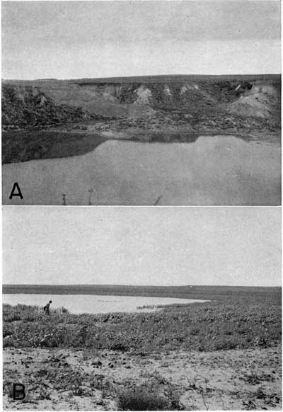
Although this sink hole is of small extent, it indicates that solution of the underlying salt has not entirely ceased, and gives a clue as to the development of sink holes in the past. In the rapid-collapse type of sink, typified by the "Meade salt sink," the walls initially are quite steep, but the steep sides are attacked almost immediately by erosion, and minor gulleys soon develop. As this process proceeds the areal extent of the surface depression increases, the side slopes become more gentle, and the hole gradually is filled. Three photographs that show this progressive development are reproduced in plates 3 and 4. Plate 3 is a view of the "Meade salt sink" taken by W. D. Johnson (1901, pl. 137-B) in 1898 or 1899, and plate 4A is a view of the same sink taken in 1939 from approximately the same point. The modification of the rim and the building of the small delta that have taken place during a period of 40 years are clearly shown. Plate 4B shows what is believed to be a later stage of development, in a similar sink in the southeastern part of the county.
Plate 3--"Meade salt sink." Sink hole located 1 1/2 miles south of Meade. Photograph made in 1898 or 1899 by W.D. Johnson. A larger verison of this image is available.
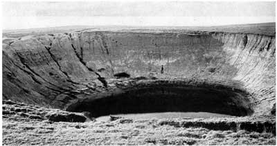
Plate 4--Sink holes in Meade County. A, "Meade salt sink" as it appeared in 1939 (photograph taken from approximately the same angle as the one shown in plate 3). B, sink near Lakeland, NW sec. 30, T. 34 S., R. 26 W. (photograph taken August 1940). Larger verisons of these images are available.
Only a few of the sink holes in Meade County are of the simple collapse type; most of them are more complex and comprise two or more sinks immediately adjacent or superimposed, and so the surface expression and contained deposits differ from the simple type. Such a concentration of sink-hole activity may occur in a roughly circular area so that the ultimate surface expression appears as a simple sink. In the complex type of sink, however, different parts of the floor have subsided at different times, at different rates, or both. Sinks of this type that have been dissected (illustrated by the dissected sink southwest of Nye, in Beaver County, Oklahoma) reveal a complex sequence of deposits that dip steeply in diverse directions and that exhibit little apparent continuity from one part of the sink to another. On the contrary, in large dissected sinks of the simple types, such as the sink on the Jones ranch about 8 miles southeast of Meade, the exposed beds dip only slightly; and, in general, there is a rough continuity of beds over much of the basin.
Compound sinks may be formed from several small sinks that have developed quite close together and have gone through their early stages of development independently of one another (Frye and Schoff, 1942). Erosion of the individual sinks ultimately merges them together to form an irregular depression, the floor of which is composed of small connected basins. There are no good examples of this type of sink in Meade County, but the Ashland and Englewood basins of Clark County (adjacent to Meade County on the east) appear to be large examples of this type of sink. Part of the valley of Crooked Creek, between south-central Meade County and the Oklahoma state line, may be considered a special type of compound sink. Through this part of its course Crooked Creek follows a series of connected sink holes, now partly dissected, that were apparently captured progressively by the stream.
Meade lake--After the close of Pleistocene time and the completion of the major solutional subsidence in the area northeast of Meade and west of Fowler, the Meade basin probably was occupied temporarily by a lake. The evidence indicating the existence of a late Pleistocene or early Recent lake in this basin is not conclusive but is strongly suggestive. The main points favoring the existence of such a lake are as follows: (1) The topographic basin had no outlet until the capture of the lower part of Crooked Creek valley by a stream, sometime during the late Pleistocene or early Recent, and until that stream had incised its valley to a depth of 50 feet or more at a point near the city of Meade. As the beds in which the valley was cut are of Pleistocene age, the downcutting could not have taken place until very late in the Pleistocene or during the Recent. As shown in figure 2, there is a marked steepening of the gradient of crooked creek below Meade; whereas, above Meade the profile is quite normal except for the unusual flatness of the segment from Meade to Fowler. (2) The floor of this basin is still subsiding somewhat as indicated by the anomalous position of ponds with respect to the position of the channel of Crooked Creek (Frye, 1941). (3) The bluffs along the west side of the basin north of Meade are quite steep and present a profile similar to wave-cut cliffs in relatively nonresistant material. The bluffs bevel the edges of nearly horizontal strata, are at all points two miles or more west of Crooked Creek, and are separated from that creek by a long sloping terrace. They bear little resemblance to stream-cut bluffs and cannot be explained by faulting, as test drilling failed to reveal the presence of a fault. (4) An area of sand dunes occurs along the East Side of the basin and is best developed north of Fowler. Along the sloping western or basinward side of this dune area occur narrow elongate ridges of sand, now grass covered, that trend roughly parallel to the contours and are nearly symmetrical in cross section. In my opinion these sand ridges were formed as beach ridges along the northeast side of "Meade Lake," and the adjacent area of dunes is directly related to this ancient beach. (5) The outline of the basin suggests the former presence of a lake. Spurs that once projected into the basin are rounded and the outlet of the basin is through a sharply constricted valley near Meade.
The Meade lake was drained when Crooked Creek captured the basin at Meade, and, as stated earlier, this capture probably occurred in late Pleistocene or early Recent times. A permanent body of water probably existed in this basin for some time prior to its capture, despite the low rainfall and high rate of evaporation now prevailing in the area, partly because there probably was as large or larger contribution to the lake from ground-water discharge--which is now carried away by surface drainage--as from surface runoff.
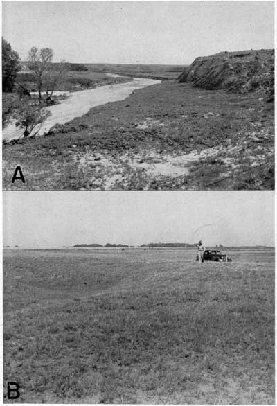
Recent deposition--The Recent history of Meade County has been dominantly one of erosion. In several areas, however, Recent stream deposits were laid down. Much of the floor of the Meade basin is underlain by Recent deposits brought in by Crooked Creek and its tributaries. Many shallow depressions on the floor of this basin are being filled by stream-born sediments at the present time. Natural levees (Frye, 1940, p. 16; 1941) have been built by Crooked Creek and its tributaries in part of the basin (see pl. 5B) ; and, as the channels of these streams have shifted laterally, parallel systems of levees have been built within a belt that locally reaches a mile in width.
Very thin alluvium of Recent age occurs along part of Crooked Creek valley, south of Meade, and along the Cimarron valley. Alluvium (shown in pl. 5A) and low terrace deposits of Recent age occur along Sand Creek and some of its tributaries and along some of the minor tributaries to Cimarron River. Sink-hole fillings of Recent age were laid down by minor streams that empty into isolated areas of subsidence.
Plate 5--Stream velleys in Meade County. A, Sand Creek valley, northeast of Jones ranch. Pleistocene beds are exposed along the valley walls, and water-bearing alluvium occurs in the valley bottom. B, Natural levee built by a tributary of Crooked Creek, about halfway between Meade and Fowler (photograph by H.T.U. Smith). Larger verisons of these images are available.
Physiographic Divisions
Fenneman (1931, pl. 1) has drawn the boundary between the High Plains and the Plains Border sections of the Great Plains physiographic province diagonally north-northeast across Meade County. This division of the county into two parts physiographically--High Plains in the west and northwest and Plains Border in the east and southeast--appears to be very satisfactory. It is presumed that this boundary line is intended to coincide with a distinct break in slope that parallels Crooked Creek, south of Meade, and lies several miles to the west of that stream. The part of the county that lies in the High Plains section is a flat, featureless plain, sloping toward the east and southeast, modified only by sand dunes, and, near the Oklahoma line, deeply trenched by the valley of the Cimarron River. The part of the county in the Plains Border section includes, in addition to the Meade basin and Crooked Creek valley, some undissected upland remnants, locally mantled by dune sand and pitted by sink holes, and a belt of dissected Permian rocks that marks the western edge of the Ashland and Englewood basins.
Smith (1940, pp. 140, 141) has described many physiographic divisions in southwestern Kansas, eight of which either enter or border Meade County. Some of Smith's divisions are based upon rather minute variations of topography and, since they have not been grouped into larger units, tend to obscure the major divisions. Of his upland units I fail to see any valid reason for distinguishing the Haskell area from the Cimarron Bend area. They are both upland areas of quite similar appearance and geologic history and are separated only by the Cimarron valley. The Cimarron valley lowland area, which consists only of the valley of the Cimarron River, does not seem to justify the use of a separate physiographic division. It is true that it is the only important valley in this part of the county, but it seems very doubtful whether valleys should be set aside as separate physiographic divisions distinct from the adjacent uplands. If this practice were followed in an area where many important tributaries entered the master stream it would approach an absurdity. For the foregoing reasons the Haskell and Cimarron bend upland areas and the Cimarron valley lowland area are here considered minor divisions of the High Plains section.
In Meade County the Plains Border section includes five divisions described by Smith: the Odee and Minneola upland areas, the Meade lowland area, Red Hills, and Cimarron valley area. The Ashland basin is immediately adjacent to the county on the east. These divisions of the Plains Border section seem to have more validity than those of the High Plains section. Most of them have distinctive features of topography and are recognizable in the field. For the sake of simplicity, however, it probably would have been better to include the Odee and Minneola upland areas in one division because they are quit similar topographically, have had a similar geologic history, and are now separated only by the valley of Crooked Creek. Also it seems inadvisable to include the valley of Crooked Creek east of the Crooked Creek fault as a part of the Meade lowland area for the same reasons applied to the Cimarron valley area.
In conclusion, it is my opinion that Meade County is properly divided physiographically into two sections--the High Plains in the west and northwest and the Plains Border in the east and southeast. The Plains Border section includes as minor divisions the Meade area, the Minneola-Odee upland area, the Red Hills, and the Ashland-Englewood basin.
Prev Page--Geography || Next Page--Ground Water
Kansas Geological Survey, Geologic History of Kansas
Comments to webadmin@kgs.ku.edu
Web version February 2004. Original publication date Dec. 1942.
URL=http://www.kgs.ku.edu/General/Geology/Meade/05_geol.html