![]()
Prev Page--Ground Water || Next Page--Shallow Ground Water
Artesian Water
History of Development in the Meade Artesian Basin
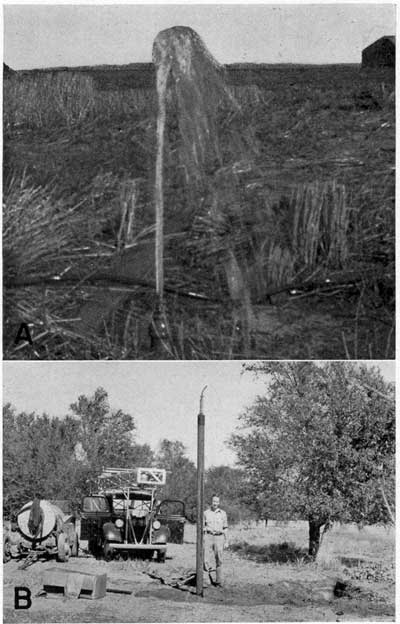
The first flowing artesian well was drilled in the Meade basin in 1886 on the farm of B. F. Cox (NE NE sec. 5, T. 31 S., R. 27 W.). The second flowing well was drilled later in the same year on the Jasper farm (SE SW sec. 33, T. 30 S., R. 27 W.), and in 1887 the third well was drilled on the farm of Frank Sourbeer (SE SE sec. 31, T. 30 S., R. 27 W.). Following the drilling of these three wells, the development of the basin proceeded rapidly, reaching its peak about 1900. By that time several hundred flowing wells had been drilled. Drilling has since continued in the basin, although recently the number of new wells added each year has been very small. Plates 6 and 7 show typical flowing wells of small diameter. The wells on the farm of W. W. Marr (pl. 6A) and on the Leach farm (pl. 7A) were constructed at about the time of maximum drilling activity in the basin. A well completed in 1939 on the farm of C. F. Wells, about a quarter of a mile west of the second artesian well drilled in the basin, is shown in plate 6B; and plate 7B shows a test well in Meade County State Park, drilled in 1939, which was cased to a depth of 30 feet and flowed with a head of 17.4 feet above the land surface.
Plate 6--Flowing wells of small diameter. A, Well 56 on the farm of W.W. Marr. B, Well 81 on the farm of C.F. Wells. A larger version of this plate is available.
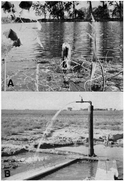
Plate 7--Flowing wells. A, Well 181 on the farm of M.L. Leach, NE NE sec. 12, T 31 S., R. 28 W. B, Flowing well (310) produced from test well in Meade County State Park. This well was later plugged. Portable drilling machine in background. A larger version of this plate is available.
Most of the wells were drilled either by the jetting method or by the hydraulic rotary method. Horse power was quite generally utilized by the early drillers, and the drilling tools were light and incapable of penetrating hard rock. Most of the wells range in diameter from 1.5 inches to 3 inches, although there are a few wells of larger diameter. Most of the early wells are uncased, except for about 30 feet of pipe left in the upper part of the hole. In recent years most of the new wells have been cased to their full depth. The bottom part of the casing is generally perforated and serves as a screen. It is estimated that approximately 1,000 flowing wells have been drilled in the basin since 1886. Only a few hundred wells, however, are in usable condition at the present time.
Irrigation from pumped wells is a relatively recent development in the Meade basin. With the exception of a well on the Norman farm (NE sec. 6, T. 31 S., R. 27 W.), which was pumped for irrigation purposes in 1909 only, and a well drilled a few years later on the Walker farm (SW sec. 4, T. 30 S., R. 26 W.), but not used extensively until the last few years, the first large, pumped irrigation well in the county was drilled in 1928 by L. L. Meng in the SE sec. 18, T. 30 S., R. 26 W. Since that date ten irrigation wells have been drilled and put into operation in the artesian basin. These wells, with one exception, are in the parts of the basin in which the pressure-head of the ground water is not sufficient to produce flows at the surface. Three typical irrigation wells are shown in plates 8 and 9. Two of these (pls. 8A and 9A) are situated in the artesian basin and have relatively low lifts, whereas the well shown in plate 8B is situated on the High Plains and has a static water level of more than 150 feet below the surface.
Plate 8--Irrigation wells in operation. A, Well 297 on the farm of Henry Borchers, SW NW sec. 29, T. 33 S., R. 28 W. B, Well 272 on the farm of C.W. Holmes, NE sec. 35, T. 32 S., R. 30 W. A larger version of this plate is available.
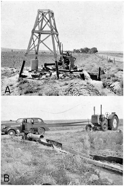
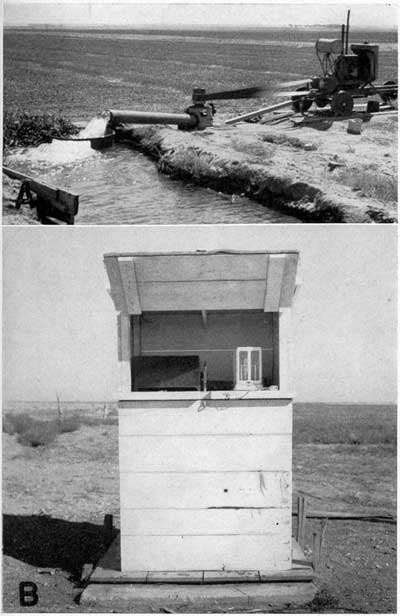
Plate 9--Irrigation and observation wells on the Christopher Sobba farm northwest of Fowler. A, Irrigation well (38) in operation. B, Shelter enclosing automatic water-stage recorder and recording microbargraph in operation at observation well (37), 320 feet north of irrigation well. A larger version of this plate is available.
Principles of Occurrence
A general discussion of the occurrence of ground water in Meade County is given on [the previous web page]; this discussion, therefore, pertains only to the occurrence of artesian water--ground water that, when encountered in wells, rises above the level of the local water table or, as in part of this area, that rises high enough to flow at the land surface. As shown in figure 4, alternate beds of permeable and relatively impermeable material dip downward beneath the floor of the Meade artesian basin. Water entering the permeable strata northwest of this area at an elevation higher than the floor of the basin moves down the dip between the confining layers of relatively impervious material toward the lowest part of the basin, where it is under artesian pressure. In several parts of the basin the water is under sufficient head to flow at the surface through artesian springs or flowing artesian wells.Areas of Artesian Flow
The areas in Meade County in which artesian flows could be obtained in 1939 are shown in plate 2. It is evident from the map that the location and shape of the areas of flow are controlled largely by the topography, and that the extent of such areas will vary from time to time with the fluctuations of the pressure-head of the artesian water. Little accurate historical information is available as to the former extent of the flowing well area; it is probable, however, that the area has decreased only slightly since the earliest development. There may have been some decrease in the area of flow west of Fowler.
In Meade County there are six distinct areas in which flowing wells can be obtained. These areas are shown in plate 2, and each is discussed briefly below.
Meade district--The Meade district is by far the largest and most important of the flowing well areas. It includes approximately 33 square miles, in which are found more than 200 flowing wells in usable condition at the present time. This area extends along the valley of Crooked Creek in a narrow strip for about 12 miles south of Meade. North of Meade it broadens into the Meade basin proper, extending to within a mile of Fowler on the east, and to within 3 1/2 miles of the Ford county line on the north.
State Park district--The State Park district, comprising less than 1 square mile, is situated about 10 miles southwest of Meade. Although no permanent artesian wells exist in this district, several large artesian springs supply water for the hatchery ponds at the State Park. During the fall of 1939, four test holes were drilled by the State and Federal Geological Surveys on the grounds of the park. Two of these wells were flushed out and cased to a shallow depth so that measurements of the artesian head could be made. In one well the water rose to a point 17.4 feet above the land surface. All test holes were plugged after these measurements were made.
Berghaus district--The Berghaus flowing well district embraces about 0.25 square mile in sec. 33, T. 32 S., R. 29 W., most of which is on the Berghaus property along a tributary to Crooked Creek about 3 miles north-northwest of Meade County State Park. As the valley bottom is narrow, and the bluffs steep, the strip enclosed within the zero line, plate 2, is narrow. In this district there is one small flowing well, which is situated at the site of a former spring.
Big Springs Ranch district--A flowing well area of less than 1 square mile occurs along Spring Creek on the Big Springs Ranch (secs. 17, 20, and 21, T. 32 S., R. 28 W.), 3 miles southwest of Meade. There are several large springs along the valley flat, and three small flowing wells near the Big Springs Ranch house. This district is less than 1 mile from the southern part of the Meade district.
Fowler district--Flowing wells occur along the valley of Crooked Creek north of Fowler to the Ford county line, and along the valley of its tributary, Spring Creek (secs. 3, 4, 9, 16, 20, and 29, T. 30 S., R. 26 W.). This area is separated from the eastern extension of the Meade district by an area of nonflowing wells in which the water rises to levels within a few feet of the surface. The district includes an area in Meade County of somewhat more than 1 square mile, and in 1939 it contained 13 flowing wells.
Eastern district--The eastern district, comprising an isolated filled sinkhole, is about 7 miles southeast of Meade. This small area contains water under artesian pressure, and at least one flowing well has been drilled in it. The area of flow is restricted to the valley bottoms of Sand Creek and its tributaries, and seems to Include less than 0.25 square mile, confined entirely to sec. 4, T. 33 S., R. 27 W. The area of flow seemingly has decreased somewhat as a result of pumping from a well that formerly flowed.
The Piezometric Surface and Movement of Artesian Water
The shape and slope of the piezometric surface has been described in an earlier section. As shown in plate 1, this surface slopes toward the southeast, and the movement of artesian water is in that direction, or at right angles to the contours. The rate of movement is determined by the steepness of the slope and by the character of the material through which the water moves. Thus, water moves from the northwestern part of the county southeastward into the Meade basin, as indicated by the contours on the piezometric surface, and is discharged by springs in the flowing well areas described above and shown in plate 2.
Head of Artesian Water
The hydrostatic level, or static water level, of the artesian water at any point is the level to which the water will rise in a tightly cased well drilled to the artesian reservoir. If the static water level stands above the land surface, the well will overflow at the surface; if a flowing well is tightly cased and capped, the artesian water will exert a pressure that can be measured. The term head, as used in this report, refers to the height, in feet, that the water will rise above the land surface in a tightly cased flowing artesian well. The heads of flowing wells given in plate 2 and elsewhere in this report were measured in the following manner. The discharge pipe was closed by inserting a plumber's soil-pipe test plug of the proper size. The seal between the test plug and the well casing is effected by a soft rubber collar that is expanded outwardly by turning a large wing nut. A length of garden hose was then attached to the test plug and the open end of the hose elevated until the flow just ceased. The hose was kept in this elevated position so as to prevent flow until all the discernible recovery had taken place. The height of the top of the hose above a fixed point then was determined with a steel tape. Some head measurements may be somewhat inaccurate owing to slight leaks in the equipment or in the casings of the wells. In such wells the heads determined by this method should, therefore, be regarded as minimum heads.
The piezometric surface, or pressure-indicating surface, of an artesian aquifer is an imaginary surface that everywhere coincides with the static level, or head, of the water in the aquifer.
Original Head
The original head of the artesian water in the Meade basin is not definitely known. The earliest known measurements of head in this area were made by W. D. Johnson (1901, p. 718), who, in 1898 or 1899, visited 209 flowing wells in use in the basin. How many of these wells were actually measured is not known, but he states that the strongest measured head in the basin at that time was 22 feet above the land surface. Conversations that I have had with old residents of the county indicate that in the early days of artesian development, a well from which water would rise above the second floor of a house was regarded as an exceptionally strong flowing well, and that water from many wells would rise only a few feet above the land surface. Also, Haworth, in 1898 (p. 53), states that the heads at that time were "perhaps always less than 20 feet." This seems to imply that Johnson's figure of 22 feet may safely be regarded as the approximate maximum head obtainable in the basin during the earliest period of record.
Head in 1923
Measurements of the pressure head of many artesian wells were made in November and December 1923, by V. W. Stanbaugh, of the Division of Water Resources, Kansas State Board of Agriculture, and were made available by George S. Knapp, chief engineer of the division. These measurements were made with a calibrated gas proving gauge reading in pounds to the square inch and having a full circle deflection of 15 pounds. The gauge was read to the nearest quarter pound and the gauge was held at the outlet of the well casing. For the purpose of discussion and comparison in this report, these values have been converted to feet of water. The heads of 24 wells measured in this way are given in column 4 of table 4. Owing to the facts that these measurements were recorded only to the nearest quarter pound, and that there are several inherent mechanical inaccuracies in this method of measurement, the 1923 heads given in the table should be regarded as accurate only within about 0.5 foot. The strongest head recorded in 1923 was 15.4 feet; no measurement was then made on the wells that showed the strongest heads in 1939, however. From the foregoing, it is estimated that the maximum head in the Meade basin in 1923 was between 18 and 20 feet above the land surface.
Table 4--Head measurements of 24 flowing artesian wells in 1923 and 1939, and decline or rise during that period.
| Location | Reported depth of well |
Diameter of well (inches) |
Head above measuring point (in feet) |
Decline (-) or rise (+) |
|
|---|---|---|---|---|---|
| 1923a | 1939b | Difference between columns 4 and 5 |
|||
| 1 | 2 | 3 | 4 | 5 | 6 |
| NW sec. 3, T. 30 S., R. 26 W | 190 | 2 | Weakcd | 2.7 | |
| NW sec. 4, T. 30 S., R. 26 W | 120 | 2 | Weakcd | 2 | |
| SW sec. 21, T. 30 S., R. 27 W | 170 | 2 | 5.8 | 6.5 | +0.7 |
| NE sec. 27, T. 30 S., R. 27 W | 175 | 3 | 10.4 | 7.7 | -2.7 |
| NW sec. 27, T. 30 S., R. 27 W | 180 | 2 | 4.6 | 3.5+ | -1.1 |
| NE sec. 29, T. 30 S., R. 27 W | 200 | 8.1 | 5.8 | -2.3 | |
| SW sec. 32, T. 30 S., R. 27 W | 175 | 2 | 3.5 | 2 | -1.5 |
| SE sec. 24, T. 30 S., R. 28 W | 180 | 2 | Weakcd | 1.5d | |
| NW sec. 4, T. 31 S., R. 27 W | 350 | 2 | 6.4 | 7.8 | +1.4 |
| NW sec. 5, T. 31 S., R. 27 W | 2 | 5.1 | 5.5 | +0.4 | |
| NW sec. 6, T. 31 S., R. 27 W | 200 | 3 | 3.5 | 3.6 | +0.1 |
| SW sec. 3, T. 31 S., R. 27 W | 3 | 5.6 | 7 | +1.4 | |
| SW sec. 5, T. 31 S., R. 27 W | 3 | 4.6 | 4.8 | +0.2 | |
| SW sec. 6, T. 31 S., R. 27 W | 260 | 2 | 10.4 | 9.2 | -1.2 |
| SW sec. 6, T. 31 S., R. 27 W | 190 | 2 | 6.3 | 2.5 | -3.8 |
| SE sec. 6, T. 31 S., R. 27 W | 260 | 2 | 5.1 | 4.5 | -0.6 |
| NE sec. 8, T. 31 S., R. 27 W | 180 | 2 | 10.3 | 7.6 | -2.7 |
| NW sec. 18, T. 31 S., R. 27 W | 175 | 12.7 | 5.9 | -6.8 | |
| NE sec. 12, T. 31 S., R. 28 W | 150 | 4 | 6.9 | 5.7 | -1.2 |
| SE sec. 12, T. 31 S., R. 28 W | 140 | 3 | 4.6 | 4.9 | +0.3 |
| NE sec. 13, T. 31 S., R. 28 W | 300 | 3 | 15.4 | 9.6 | -5.8 |
| NW sec. 12, T. 32 S., R. 28 W | 180 | 2 | 3.5 | 0.2 | -3.3 |
| SW sec. 22, T. 32 S., R. 28 W | 150 | 2 | 3.5 | 2 | -1.5 |
| NE sec. 4, T. 33 S., R. 28 W | 180 | 2 | 7.4 | 1 | -6.4 |
| Average | 195 | 6.8 | 5.1 | -1.7 | |
a. Heads measured in November and December, 1923, by V. W. Stanbaugh, Division of Water Resources, Kansas State Board of Agriculture. Measurements were made in pounds to the square inch and have been converted to feet. Believed to be accurate within 0.5 foot
b. Heads measured by the writer in July-September, 1939, by the method described in the text, Accurate to approximately 0.2 foot.
c. Head too weak to register a readable amount on the gauge, probably less than 2.5 feet.
d. Not included in average.
Head in 1939
In July, August, and September 1939, head measurements were made by the writer on 145 flowing wells in Meade County. The location of these wells, and 40 other flowing wells, on which flow measurements only were obtained, are shown in plate 2. The strongest head measured in 1939 was 17.4 feet above the land surface, and was obtained in a test well in Meade County State Park. Inasmuch as all the earlier measurements were made in the Meade and Fowler districts, this well cannot be compared with them. The pressure in the strongest two flowing wells measured in the Meade basin proper was sufficient to force water to heights of 17.0 feet and 16.5 feet.
Decline in Head
On the basis of present data, the decline in head in the Meade basin during the last 50 years does not seem to have been great. In order to show the extent of this decline, some of the data presented earlier will be reviewed and compared.
As pointed out, the maximum head obtainable in the basin when development was initiated probably was not greater than 22 feet above the land surface, and the maximum head measured in 1939 was 17 feet above the land surface. Thus, it seems that the maximum head measured in 1898 was five feet higher than the maximum head measured in 1939. It is the opinion of the writer that this figure is not accurate and is probably larger than the actual decline in maximum head during this period. This opinion is based on the following facts: (1) Johnson did not give the location of the strongest well that he measured and, thus, it is impossible to know whether this well was among those measured in 1939, if indeed it is still in existence; (2) the earliest, measurements were made on relatively new wells, whereas most of the 1939 measurements were made on old wells, some of which are known to be "sanded up," or to have underground leaks in the rusted casing; and (3) the strongest wells at the present time are situated in areas where the concentration of wells seems to be greater than any that existed in the basin 40 years ago; and, as it was impracticable to close in many of the wells while measurements were being made, the well being measured was undoubtedly influenced more or less by the cones of depression, or areas of pressure relief, of the near-by wells. When these facts are considered and given proper weight, it seems safe to conclude that the total decline in maximum head, by 1939, has been less than five feet but more than three feet.
Head measurements made in 1923 are given in table 4. Due to the fact that the strongest heads were not necessarily included in the measurements, no comparison of maximum heads can be made on the basis of these data. Of the wells measured in 1923, however, 24 were remeasured in 1939. As indicated in table 4, the average decline in the head of the 24 wells during the 15 1/2-year period is 1.7 feet. It should be noted, however, that the change in head of individual wells ranged from a slight increase for some wells to a decline of 6.8 feet in one well. It should also be noted that the 1923 measurements were made in the winter, whereas the 1939 measurements were made in the summer and fall. The period of record of the observation wells in the area is not yet sufficiently long to determine with certainty at what times during the year the water in the artesian wells stands at the highest and lowest levels, but the records to date indicate that in general the water level is highest during the spring and early summer and lowest during the fall. It is evident that the decline in artesian pressure has been small.
Fluctuations in Head
Fluctuations caused by precipitation--Fluctuations of water level under nonartesian conditions caused by precipitation were discussed in an earlier section, and only those special considerations involved under artesian conditions are mentioned here. Precipitation that falls in the discharge area of an artesian basin has no effect upon the ground-water level, or pressure head, for in such areas the artesian water is effectively sealed from the surface by impervious beds or else the artesian pressure could not be maintained. Under artesian conditions, therefore, it is the precipitation that falls on the intake or recharge area that can produce fluctuations in water level, or head. Thus, the effect of precipitation on water levels must be transmitted a considerable distance through the artesian water-bearing beds. The transmission of water under hydrostatic pressure from a distance, with the accompanying frictional losses, leaks, and other complicating factors, cause the fluctuations in water level or head to lag far behind the time of recharge and to be somewhat "dampened." In order to make any accurate correlation of water-level fluctuations in the artesian basin with the precipitation on the recharge area to the northwest several additional years of water level records will be needed. At the time of writing more than 2 years records of water-level fluctuations in Meade County are available (Meinzer and Wenzel 1941, 1941a). One observation well (100), which penetrates the artesian water outside the flowing well district at a considerable distance from any possible influence by pumping, shows only a slight fluctuation in water level during the entire period of record, and these small fluctuations do not seem to be correlative with periods of rainfall and drought.
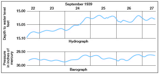
Fluctuations caused by changes in barometric pressure--An automatic water-stage recorder has been maintained on a well (37) owned by Christopher Sobba, and the record shows a pronounced barometric effect. The effect of atmospheric pressure on the water level has been summarized by Meinzer (1932, pp. 140-142) as follows:
If a shallow well ends in a formation that lies at the surface and is freely permeable throughout, only slight barometric effects or none at all are to be expected, because any change in the atmospheric pressure is transmitted almost as freely to the water table through the permeable material as to the water level in the well . . . if a well ends in an artesian formation and this formation or the overlying confining beds have sufficient strength to resist deformation by slight changes in pressure at the surface, the well will act as a barometer. The fluctuations of its water level will have virtually the same range of fluctuations as would be shown by a water barometer, or 13.5 times the range of a mercury barometer. If a well ends in an artesian formation that has volume elasticity, such as incoherent sand, and is confined beneath beds of soft shale that is impermeable but yields to even slight pressures, its water level will have smaller fluctuations resulting from atmospheric changes than that of a water barometer, and the ratio of the movements in the well to the corresponding movements in the barometer should give a measure of the resistance of the water-bearing and confining beds.
A hydrograph obtained from the automatic water-stage recorder and the inverted barograph obtained from a recording microbarograph located in the same shelter are shown in figure 7. It can be seen from these graphs that the fluctuation of the water surface is only about twice as great as the comparable fluctuations in a column of mercury; hence, this well may be said to have a barometric efficiency of only about 15 percent.. It may be concluded either that the resistance to deformation of the artesian aquifer and the confining beds is probably not very great or that the seal effected by the confining beds is not complete.
Figure 7--Hydrograph and inverted barograph obtained at the observation well (37) on the farm of Christopher Sobba, Northwest of Fowler.
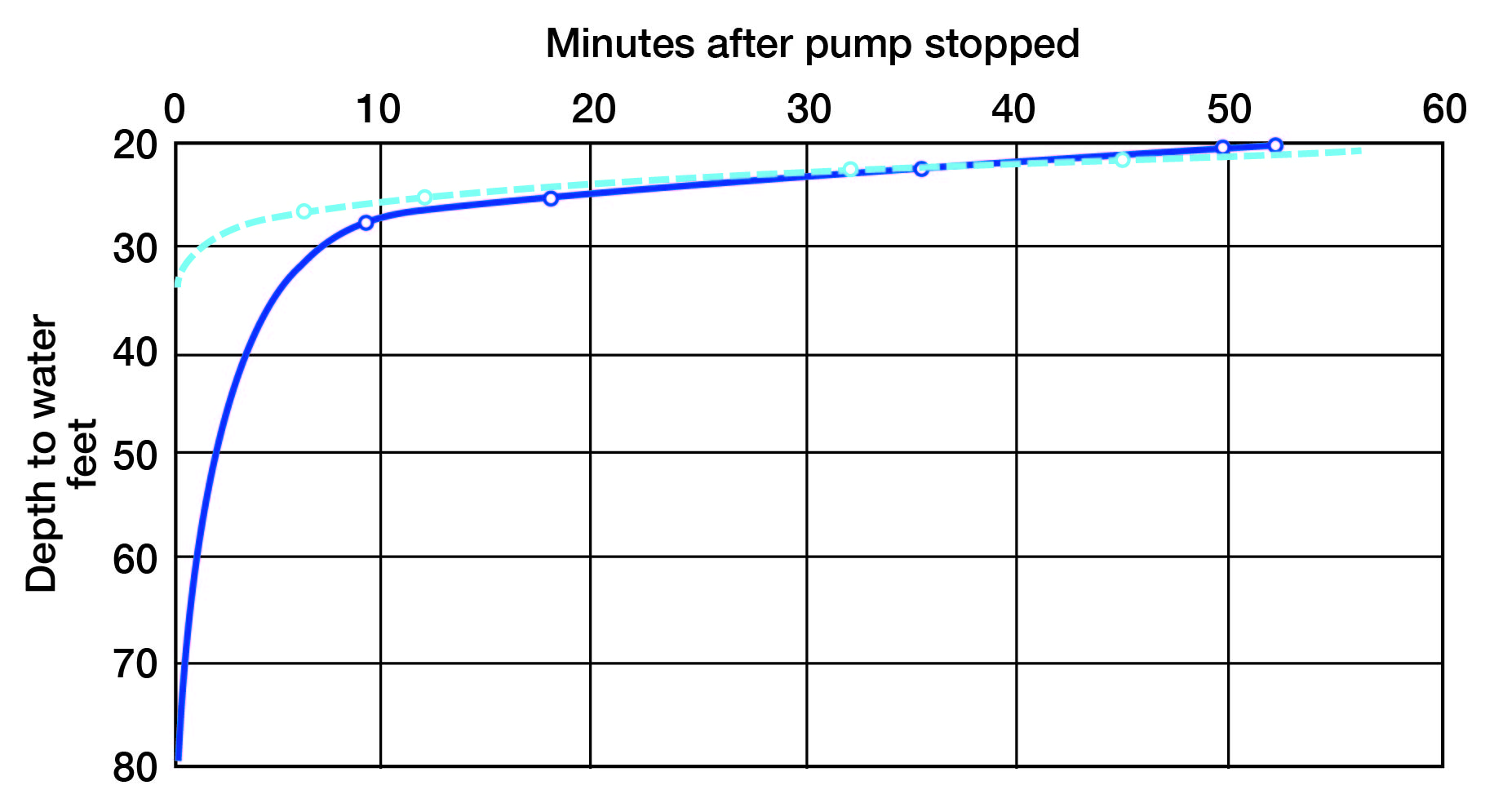
Fluctuations caused by pumping--Fluctuations of water level caused by pumping are of particular interest. Data bearing on this problem in the Meade basin are available from several sources. The observation well (37) mentioned above is situated 320 feet from a pumped irrigation well (38), and a hydrograph from the observation well is shown in figure 8, together with the pumping record of the irrigation well. This hydrograph illustrates the speed with which draw-down, or release of pressure, is transmitted through the artesian aquifer, and the extent of the draw-down in the water level at a distance of 320 feet from the pumped well. The irrigation well was pumped at a rate of approximately 850 gallons a minute and the first period of pumping indicated on the graph represents the first pumping of the irrigation well after a winter of rest. Comparable recovery curves are shown in figure 9 of two of the municipal wells at Meade. The sharp draw-downs and rapid recoveries as shown by these curves, are typical of artesian conditions.
Figure 8--Hydrograph of observation well (37) and pumpage record of irrigation well (38) 320 feet distant. Located on the farm of Christopher Sobba, northwest of Fowler.
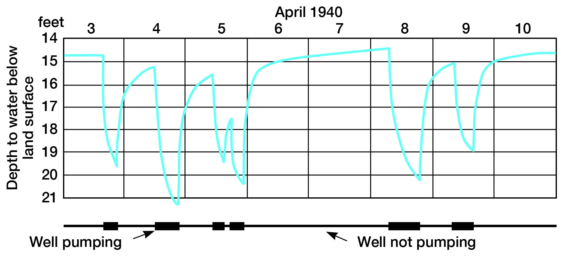
Figure 9--Recovery curves of two of the municipal wells (244 and 245) at Meade. The solid line represents the pumped well and the dashed line an unpumped well 120 feet distant. Pump was stopped after about 4 hours of pumping. Wells located at east edge of city.
A pumping experiment on a large scale, carried out in the flowing-well area in 1909, was reported to the writer by several residents of Meade County, and is of considerable interest in a study of fluctuations caused by pumping. A 5 5/8-inch artesian well was drilled to a depth of 190 feet in the SE NE sec. 6, T. 31 S., R. 27 W. This well was equipped with a centrifugal pump, and pumped for irrigation at a rate of 700 gallons a minute. After this well had been pumped for ten consecutive days, a well three-quarters of a mile away ceased flowing. On August 28, 1939, the well located three-quarters of a mile from the pumped well was located and was found to have a head of 4.8 feet above the top of the discharge pipe. It is reported that the discharge pipe in 1909 was lower than it was in 1939, and the well at that time (prior to the near-by pumping) probably had a somewhat higher head than it does now. From the foregoing data it may safely be concluded that the pumping of the irrigation well during 10 days lowered the piezometric surface by more than 4.8 feet over an area of more than 1.75 square miles.
Discharge of Artesian Water
The discharge of water from the artesian water-bearing beds seems to take place in the following three ways: (1) Natural discharge at the surface from springs and seeps and by transpiration and evaporation; (2) discharge from wells by natural flow and by pumping; and (3) underground leakage.
Natural Discharge at the Surface
Springs--Flow from artesian springs constitutes one of the most important means of discharge of artesian water in the area. The largest springs at the present time are those south of Meade, along valleys tributary to Crooked Creek from the west. The largest spring in the county, known as Big Spring, is situated on the Big Springs ranch, about 3 miles southwest of Meade. A view of the discharge channel of this spring is shown in plate 10A. From measurements of the cross-sectional area of the discharge channel and the surface velocity of the water the flow from this spring was determined to be about 840 gallons a minute on August 4, 1939. There are several smaller springs along this same valley. The other locality of important. Spring discharge is in Meade County State Park; here, three springs, located within a few hundred yards of each other, were estimated to have an aggregate discharge of about 680 gallons a minute. Several small springs occur along the western side of the Meade district, both north and south of Meade. The total annual discharge of springs in the area in 1939 was estimated to be about 2,010 gallons a minute, or about 3,240 acre-feet annually. (One acre-foot is the quantity of water required to cover one acre to a depth of one foot, or 325,851 gallons.)
Although the earlier investigators made few, if any, measurements of spring flows in this area, it is evident that since the early development there has been a marked decrease in the total discharge from artesian springs. Haworth (1897, pp. 54, 55) states that, "The most noted area of springs is in the vicinity of Mr. Simms's ranch, a mile and a half north of Fowler." He described these springs as being of such extent that cattle became bogged down in them, and sank entirely out of sight. Only small springs were found there in 1939. Haworth also notes that the springs along Spring Creek, on the Big Springs and Crooked L ranches, had an approximate annual flow of 3,000 acre-feet. The total annual discharge from these springs in 1939 was estimated to be only about 1,300 acre-feet. Because of insufficient data it is impossible to determine whether or not there has been a decrease of flow from the springs in the Meade County State Park; owing to the isolated position of these springs, however, it is possible that their discharge has remained about the same during the last 40 years. In addition to the decreased flow from the important springs it is reported that the flow from numerous small springs has decreased considerably or ceased entirely.
It is estimated that the total artesian spring discharge in Meade County has decreased more than 50 percent during the last 45 years, or from more than 7,000 acre-feet a year to about 3,240 acre-feet a year in 1939.
Seepage into streams--Several of the former springs may now constitute seepages into streams, but the quantity of artesian water discharged in this way appears to be insignificant. The most important seepages are from the body of shallow ground water and are probably supplied in part indirectly from the artesian reservoir. The quantity of artesian water discharged in this way is included in the estimate for underground leakage given below.
Transpiration and evaporation--There seems to be little or no direct loss of artesian water by transpiration or evaporation. These processes play an important part in the discharge of shallow ground water in the county. The shallow ground water is derived mainly by leakage from the artesian reservoir, however; hence, loss of shallow ground water by transpiration and evaporation might be said to have an indirect bearing on the artesian reservoir. The quantity of water lost by this means is included in the estimate of underground leakage given below.
Discharge from Artesian Wells
Flowing wells--Flow measurements were made on 180 artesian wells in 1939. These measurements were made by catching the discharged water in a container of known volume--in most cases a one-gallon can--and determining with a stop watch the length of time required to fill the container. Some of the larger flows were measured in five-gallon cans and a few were measured in large drums that had been calibrated by filling from a one-gallon can. The flows were found to range from a few drops a minute to about 100 gallons a minute, and the average discharge was about seven gallons a minute. The total annual discharge from flowing wells in 1939 was about 3,230 acre-feet. In 1898 or 1899, Johnson (1901, p. 726) estimated an aggregate flow of four second feet., which would amount to 2,896 acre-feet annually. These figures indicate only a small increase in the total annual discharge from flowing wells in the area during the last 40 years.
Nonflowing wells--Of the total discharge of artesian water in 1939, approximately 208,100,000 gallons, or about 630 acre-feet, was brought to the surface by pumping. Most of this water was pumped for municipal, industrial, and irrigation supplies. Owing to the facts that the use of pumped irrigation wells is a relatively new development in the basin, and that the quantity pumped for municipal use has increased, it seems safe to conclude that the quantity of water pumped in this area probably has increased by more than 50 percent during the last 15 years.
Relation of spring flow to well discharge--It is estimated that the total discharge from artesian springs has decreased by more than 50 percent, or about 3,760 acre-feet annually. The total discharge from artesian wells in the area in 1939 was about 3,860 acre-feet annually (3,230 acre-feet from flowing wells plus 830 acre-feet from pumped wells). This indicates that the total discharge of artesian water in the basin in 1939 was only slightly more than the total discharge prior to the widespread development of artesian wells. This fact is particularly important in considering the relatively insignificant decline in head that seems to have occurred during this same period.
Underground Leakage
An undetermined quantity of water is discharged from the artesian water-bearing beds by upward leakage through the confining beds into the shallow-water reservoir. The fact that the upper seal in this area may not be complete was first recognized by Johnson (1901, p. 727). These confining beds are composed of silt and clay, and a small amount of water under artesian pressure probably migrates upward through them. Leakage also occurs by way of abandoned and improperly constructed wells and along minor faults and fractures produced by the irregular settling of these unconsolidated sediments in response to solution of underlying salt beds. It is probable that recent geophysical exploration for oil has added to the leaks in the upper confining beds. Holes of small diameter were drilled into the surficial deposits and charges of explosive were set off at various depths below the surface, and it is probable that in the subsequent plugging of some of these holes the confining bed was not completely sealed. Some of the natural openings through confining beds are sufficiently large to allow water to issue at the surface as springs. In such places the quantity of water discharge is measurable at the surface and is not included with the underground leakage.
Summary of Discharge
It is believed that if consideration is given to the water discharged from the artesian water-bearing beds by upward leakage through the confining beds, along faults, and through defective and abandoned wells, the total annual discharge of artesian water may be estimated at about 10,000 acre-feet. The available discharge data are summarized in table 5.
Table 5--Summary of discharge of artesian water at the surface
| Percent of total |
Acre-feet a year |
|
|---|---|---|
| Springs | ||
| Utilized (Meade county State Park, etc.) | 16 | 1,140 |
| Wasted | 30 | 2,100 |
| Flowing wells | ||
| Utilized (Domestic, stock, and irrigation supplies) | 25 | 1,770 |
| Wasted | 20 | 1,460 |
| Nonflowing wells | ||
| Municipal and industrial supplies | 5 | 355 |
| Irrigation supplies | 4 | 285 |
| Totals | 100 | 7,110 |
Recharge to the Artesian Basin
The general aspects of ground-water recharge in Meade County have been discussed in an earlier section. Nearly all of the recharge to the artesian water-bearing beds must occur some distance to the west and north of the basin proper; in fact, most of the recharge occurs to the west of the county in Gray, Haskell and Seward counties. On the basis of preliminary data (personal communication from B. F. Latta) there seems to be a shallow groundwater divide beneath the sand hills about 10 miles south of Garden City in Finney County. This divide probably represents the northwestern limit of the recharge area effective in replenishing the artesian-water supply in Meade County. The water table in this divide area attains an altitude approaching 2,850 feet; whereas, the altitude of the water table at the northwestern corner of Meade County is about 2,680 feet. Thus, it appears that there is a substantial gradient from southern Finney County, under Haskell County, to the artesian basin in Meade County, but that the under-flow of the Arkansas valley is not a source of recharge to the artesian basin. Rain and snow falling on the surface of parts of Haskell County, southwestern Gray county, northeastern Seward county, and the southernmost part of Finney county, however, may replenish the artesian water-bearing beds.
On the basis of the foregoing, the recharge area of artesian water in the five counties involved is estimated to be of the order of 685 square miles. As the total annual discharge of artesian water is estimated to be 10,000 acre-feet, and if the recharge is assumed to be equal to the discharge, this indicates that an average recharge of about 0.27 inches may reach the water table in the areas described. Of the average annual precipitation for this area of 18 inches, therefore, possibly about 1.5 percent joins the ground-water body as a recharge. It must be remembered that this approximate quantity is an average figure and does not apply to every square mile of the area involved. In the area of sand dunes in southern Finney county and northern Haskell County the percentage is probably much greater, and in certain other parts of the area it is probably much less, and locally there may be none at all.
Although the above figures are based on the best data available at the present time, it has not been possible to draw the western limit of the recharge area exactly. That is, there is a strip of High Plains between the Cimarron valley and the sand dune area in eastern Grant county and western Haskell County that may be transmitting water eastward into this area. If this proves to be true the area of recharge should be increased and the percentage decreased. Field work has been started in Grant and Haskell counties by T. G. McLaughlin and, when completed, may supply the answer to this problem.
Prev Page--Ground Water || Next Page--Shallow Ground Water
Kansas Geological Survey, Geologic History of Kansas
Comments to webadmin@kgs.ku.edu
Web version February 2004. Original publication date Dec. 1942.
URL=http://www.kgs.ku.edu/General/Geology/Meade/07_artes.html