![]()
Prev Page--Formation Summary || Next Page--Recharge, Discharge
Ground Water
Principles of occurrence
In order to assist the reader in a better understanding of the ground-water conditions in Kiowa County, certain basic principles of the occurrence of ground water adapted from Meinzer (1923, pp. 2-102) are discussed briefly in the pages that follow. For a more detailed treatment of the subject the reader is referred to Meinzer's report and also to a report by Moore (1940).
Ground water, or underground water, is the water that supplies springs and wells. The rocks that form the outer crust of the earth are at very few places solid throughout, but contain numerous open spaces, called voids or interstices. These open spaces are the receptacles that hold the water that is found below the surface of the land and is recovered in part through wells and springs. There are many kinds of rocks, and they differ greatly in the number, size, shape, and arrangement of their interstices, and hence in their properties as containers of water. Therefore, the character, distribution, and structure of the rocks of any region determine the occurrence of water.
The amount of water that can be stored in any rock depends upon the volume of rock occupied by open spaces--that is, the porosity of the rock. Porosity is expressed as the percentage of the total volume of rock that is occupied by interstices. A rock is said to be saturated when all its interstices are filled with water. The porosity of a sedimentary rock is controlled by (1) the shape and arrangement of its constituent particles, (2) the degree of assortment of its particles, (3) the cementation and compaction to which it has been subjected since its deposition, (4) the removal of mineral matter through solution by percolating waters, and (5) the fracturing of the rock, resulting in joints and other openings. Well-sorted deposits of unconsolidated silt, sand, or gravel have a high porosity, regardless of the size of the grains. Poorly sorted deposits have a much lower porosity because the small grains fill the voids between the large grains, thus reducing the amount of open space. The pore space in some well-sorted deposits of sand or gravel may gradually be filled with cementing material, gradually reducing the porosity.
The capacity of a rock to hold water is determined by its porosity. but its capacity to yield water is determined by its permeability. The permeability of a rock may he defined as its capacity for transmitting water under hydraulic head. It is measured by the rate at which the rock will transmit water through a given cross section under a given difference of head per unit of distance. Rocks that will not transmit water may be said to be impermeable. Some deposits, such as well-sorted silt or clay, may have a high porosity but because of the minute size of the pores will transmit water only slowly. Other deposits, such as well-sorted gravel containing large openings that communicate freely with one another, will transmit water very readily. If a force greater than the force of gravity were applied to the water in the silt or clay it would probably move more readily. Part of the water in any deposit is not available to wells because it is held against the force of gravity by molecular attraction--that is, by the cohesion of the water itself and by its adhesion to the walls of the pores. The ratio of the volume of water that a rock will yield by gravity, after being saturated, to its own volume is known as the specific yield of the rock.
Below a certain level, which in Kiowa County ranges from the land surface to about 200 feet below the surface, the permeable rocks are saturated with water under hydrostatic pressure. These saturated rocks are said to be in the zone of saturation, and the upper surface of this zone is called the water table. Wells dug or drilled into the zone of saturation will become filled with ground water to the level of the water table.
The permeable rocks that lie above the zone of saturation are said to be in the zone of aeration. As water from the surface percolates slowly downward to the zone of saturation, part of it is held in the zone of aeration by the molecular attraction of the walls of the open spaces through which it passes. In fine-grained material there is invariably a moist belt in the zone of aeration just above the water table; this moist belt is known as the capillary fringe. Although water in the zone of aeration is not available to wells, much of the water in the upper part of the zone may be withdrawn by the transpiration of plants and by evaporation from the soil.
Rock Types and their Water-bearing Properties
The outer crust of the earth is made up of various kinds of material ranging from unconsolidated deposits, such as clay, silt, sand, and gravel, to consolidated rocks, such as shale, limestone, and sandstone. All these materials are called "rocks," whether they are firm and hard or loose and soft. All of the rocks within a practical drilling depth in Kiowa County are of sedimentary origin and consist chiefly of clay, shale, silt, sand, gravel, and sandstone. These rocks vary greatly in character and in their ability to store and transmit water, as brought out in the discussion below.
Sand and gravel
Sand and gravel consist of unconsolidated grains or pebbles of minerals or rocks greater than 0.062 mm in diameter. Sand ranges in grain size from 0.062 to 1 mm in diameter and gravel consists of grains and pebbles greater than 1 mm in diameter. Sand and gravel are found in the Ogallala and Meade formations and in the alluvium of the larger stream valleys. In Kiowa County more wells obtain water from sand and gravel than from any other source.
The water-bearing properties of sand and gravel differ widely and are controlled by the size of the particles, the degree of assortment, and the degree of cementation. Coarse clean well-sorted gravel is an ideal water-bearing material in that it has a high porosity, high permeability, and high specific yield; hence it absorbs water readily, stores it in large quantities, and yields it to wells freely. In some deposits, however, clay, silt, or sand mixed with the gravel reduces its porosity, permeability, and specific yield. Most of the gravel deposits in Kiowa County contain some silt and sand but nevertheless yield water very freely. Some of the gravel deposits in the Ogallala and Meade formations have been tightly cemented with lime carbonate and are therefore worthless as producers of water. The tightly cemented beds, however, are relatively thin.
Sand ranks next to gravel as a water bearer and differs from gravel in having smaller interstices; hence it will conduct water less readily and will give up a smaller proportion of its water to wells. Grains of sand, particularly fine sand, are more readily carried by water into wells. This fact raises problems in connection with the drilling and pumping of wells.
The distribution, character, thickness, and water-yielding capacity of the sand and gravel deposits in this area are described under water-bearing characteristics of rock formations.
Sandstone
Sandstone, as the name implies, is a consolidated rock composed of cemented sand grains. Quartz generally is the most common mineral in sandstone though it may consist of cemented fragments of other minerals or rocks (Allen, 1936, p. 39). The chief cementing agents of sandstone are silica, calcite, and iron oxide.
In Kiowa County sandstone occurs in the Flowerpot shale, Dog Creek shale, and Whitehorse sandstone of Permian age and in the Cheyenne sandstone, Kiowa shale, and Dakota formation of Cretaceous age. A few wells in the southeastern part of the county obtain water from sandstone in the Cheyenne and Whitehorse. One well (55) is believed to tap a sandstone bed in the Flowerpot shale and one well (91) is believed to tap a sandstone lens at the top of the Kiowa shale. No wells are known to obtain water from sandstones in the Dakota formation.
Sandstone ranks next to sand in its ability to store and transmit water. The factors determining the water-bearing properties of a sandstone are size of grain, degree of assortment, and degree of cementation. A coarse-grained well-sorted sandstone will yield water freely, whereas an equally well-sorted very fine-grained sandstone holds a relatively large part of its water and surrenders the rest very slowly. A loosely cemented very fine-grained sandstone also is undesirable because of the tendency of the grains to enter wells, thus causing damage to the pumps and often clogging the wells. The degree of assortment of the sand grains in a sandstone affects the water-bearing properties of the sandstone in the same way as in a gravel deposit. Fine sand, silt, or clay in a coarse-grained sandstone greatly decreases the porosity and permeability of the sandstone. The interstices of sandstone are small and are therefore easily closed by precipitation from percolating water. Many sandstones are so thoroughly cemented that they will not yield water. Tightly cemented sandstone may, however, contain joints and fractures that carry water.
Silt and clay
Silt and clay are composed of the very finest grained products of erosion. Silt is made up of particles from 0.005 to 0.062 mm in diameter and clay consists of particles that are less than 0.005 mm in diameter.
Silt and clay occur in all the rock formations in Kiowa County in varying amounts, and silt is the chief constituent of the Kingsdown silt. Although silt and clay generally have a high porosity and therefore contain considerable water, the water is held in the small interstices by molecular attraction; hence little or no water can drain out into wells under the incompetent force of gravity. No wells in this area obtain water from silt or clay.
Shale
Shale is an indurated clay that, upon weathering, exhibits lamination along planes that are approximately parallel to the bedding. Unlike silt or clay, most shale will not fall apart on wetting. Shale is a very poor source of water, as the available water in shale is found only in sandy zones or in joints and along open bedding planes. No wells are known to obtain water from shale in Kiowa County.
Artesian Conditions
Artesian water is ground water that rises above the level at which it is encountered in wells (Meinzer and Wenzel, 1942a, p. 451). Artesian conditions exist where a water-bearing bed is overlain by an impermeable or relatively impermeable confining bed and dips from the point of recharge to the discharge area. When a well is drilled into an artesian water-bearing bed the pressure is released and the water rises in the well. If the water rises high enough to flow at the surface the well is called a flowing artesian well.
Water in the Cheyenne sandstone is under artesian head nearly everywhere in Kiowa County except in the immediate area of outcrop. The water in the Cheyenne sandstone is confined beneath the Kiowa shale, which dips from an altitude of about 2,500 feet in the southern part of the county to an altitude of less than 1,750 feet at the northern edge of the county (Pl. 5 and Fig. 9). The water level in wells that tap the Cheyenne sandstone generally rises from several tens of feet to more than 100 feet above the point at which the water is first encountered. For example, well 66 encountered the Cheyenne at approximately 250 feet beneath the land surface, but on August 19, 1941, the measured depth to water level in the well was about 93 feet below the surface, or approximately 155 feet above the top of the water-bearing sandstone. There are no flowing artesian wells in Kiowa County and it is doubtful whether the head of the water in the Cheyenne sandstone is great enough anywhere in the county to cause a well to flow. Water from the Cheyenne sandstone generally is highly mineralized in this area (p. 86) ; therefore water from other sources is utilized wherever possible.
Although data are scanty, it is believed that the water in the Permian formations in this area also is under slight artesian head, but because of the poor quality of the water few wells have been drilled into Permian rocks (pp. 71-75).
The Water Table and Movement of Ground Water
The upper surface of the zone of saturation in ordinary permeable rock has been defined as the water table, but the water table is absent where the upper surface is formed by impermeable material, as it is in parts of Kiowa County. The water table is not a static, level surface, but generally it is a sloping surface having many irregularities. The causes of the irregularities of the water table in Kiowa County are discussed on the following pages.
Shape and Slope
The shape and slope of the water table in Kiowa County are shown on Plate 1 by means of contour lines. Each point on the water table along a given contour line has the same altitude; hence, these water-table contours show the configuration of the water surface just as topographic contours show the configuration of the land surface. Ground water moves in the direction of slope of the water table, at right angles to the water-table contours.
Plate 1 shows that ground-water enters Kiowa County from the west and moves through the county in a general easterly direction, but that the direction of movement and slope are not everywhere the same. The average gradient, of the water table beneath the sand hills upland plains (Fig. 2) is about 10 feet to the mile and ranges from about 5 feet to the mile in the central part of T. 27 S., R. 16 W. to about 15 feet to the mile along the southern edge of the upland plains. In the dissected area (Fig. 2) south of the upland plains the gradient of the water table averages approximately 20 feet to the mile and the maximum slope exceeds 40 feet to the mile.
In the northern half of Kiowa County the water table slopes to the east and maintains a nearly constant gradient across the county. In this area the water is moving through highly permeable sand and gravel, which accounts for the nearly uniform slope of the water table, although there are a few minor irregularities. The downslope flexure of the contours in T. 27 S., R. 20 W. represents a low ground-water divide that is caused by the movement of ground water toward Arkansas River, which flows northeastward just beyond the northwestern corner of Kiowa County. The downslope flexure of the contours in T. 27 S., Rs. 16, 17, and 18 W. indicates a broad relatively low ridge on the water table. This area is underlain by porous dune sand so that a large part of the water that falls as rain seeps downward to the underground reservoir where it has built up the low ridge. Influent seepage from Rattlesnake Creek has aided in forming this ridge. Ridges such as this are formed because the frictional resistance offered by the small openings in the water-bearing material prevents the water from spreading out as rapidly as it would in a body of free water, such as a lake.
In the eastern part of the sand hills and upland plains the movement of ground water changes direction from nearly east to southeast because of the discharge of ground water into Thompson, Spring, and Soldier creeks.
Other things being equal, the slope of the water table in any area varies inversely with the permeability of the water-bearing material; that is, the water assumes a steeper gradient in flowing through fine material than through coarse material, providing the same quantity of water is moving through both types of material. This probably explains, at least in part, the minor differences in the slope of the water table beneath the sand hills area and upland plains.
In the dissected area in the southern part of the county the water table has many irregularities. It will be noted that ground water enters this area from the west-northwest, but soon after entering the dissected area it encounters a ground-water divide that causes part of the water to move northeastward, part eastward, and a part southward. On nearing the point of discharge in the dissected area the water also assumes a much steeper gradient than it has to the west and north. The shape and slope of the bedrock floor formed by the underlying Cretaceous rocks may control the direction of movement and slope of the ground water in this area to a small extent, for the shape of the water table in the dissected area roughly conforms with the shape of the pre-Ogallala surface shown in Figure 10. The discharging of ground water into Turkey, Middle Kiowa, Wiggins, and East Kiowa creeks in the southwestern part of the dissected area, into Medicine Lodge River in the central part of the area, and into Mule Creek in northern Comanche County probably is the chief factor controlling the direction of movement and slope of the water table in this area, but a lower permeability of the water-bearing materials is responsible in part for the steeper slopes. This is particularly true near Medicine Lodge Valley where part of the ground water enters fine sandstone in the Dakota formation and Kiowa shale. The water moving toward the area of exposed bedrock is discharged through springs and seepage areas and leaves the county as runoff.
Much of the southeastern part of Kiowa County is underlain by relatively impermeable beds; therefore there is no table in this area and water table contours are not shown. A few in this area obtain supplies from perched bodies of water in shallow stream alluvium or from the Cheyenne sandstone or Permian beds.
Relation to Topography
The depth of water level below land surface in Kiowa County is controlled largely by the configuration of the land surface. Plate 2 shows the depth of the water level in wells in Kiowa County by means of isobath lines--lines of equal depths to water level. As shown on the plate, this depth ranges from less than 25 to nearly 200 feet. For purposes of detailed description of ground-water conditions, the county may be divided into the following four areas: sand hills, upland plains, eastern dissected area, and western disected area.
Sand hills--The location and areal extent of the sand hills are described under topography and drainage and are shown in Figure 2. The water table in this area is from 10 to about 80 feet below the land surface but in most of this area it is less than 50 feet below the surface. In the northwestern corner of the area, where the land surface slopes toward Arkansas River, and in a wide area along Rattlesnake Creek the depth to water level is less than 25 feet.
Most of the wells in the sand hills are from about 20- to 90 feet deep. The principal water-bearing beds are the sands and gravels of the Meade formation. Ground water suitable for most purposes in sufficient quantity to supply irrigation or industrial wells can be obtained from wells in the sand hills.
Upland plains--The greatest depths to water level in the county are found in the upland plains area (Fig. 2). In a large part of the upland plains the water table is from 60 to 150 feet below the surface, and in a relatively large area in T. 29 S., Rs. 19 and 20 W. it is more than 150 feet below the surface. Wells in the upland plains are 65 to 210 feet deep and most of them obtain water from the sands and gravels of the Meade formation, but a few wells may obtain at least a part of their supply from sands and gravels of the Ogallala formation. Domestic and stock water supplies are available in all parts of this area and in some places larger supplies for irrigation or industrial use can be obtained. The quality of the water makes it suitable for most purposes.
Eastern dissected area--The eastern area includes that part of the dissected area (Fig. 2) that lies within the Medicine Lodge River drainage system. No attempt was made to show the depth to water level in this area, as the relatively impermeable Kiowa shale underlies most of it. Normal water-table conditions therefore do not exist here. In many parts of this area potable water is difficult to find. Wells near the margin of the eastern disected area tap sands and gravels of the Meade and Ogallala formations and have depths to water level ranging from about 15 to 120 feet. Wells within the area underlain by Cretaceous and Permian rocks tap shallow stream alluvium, the Cheyenne sandstone (Cretaceous), or the Whitehorse sandstone (Permian), and one well (55) probably taps the Flowerpot shale (Permian). The water level in the wells (72, 73, 75, 76, 77, 79, and 88) tapping alluvium is from 4 to about 20 feet below the surface; in wells (59, 66, 80, and 100) tapping the Cheyenne sandstone it is from 55 to 142 feet below the surface; and in wells (74, 81, and 82) tapping the Whitehorse sandstone it is from about 45 to 75 feet below the surface.
Many springs and seeps occur near the northern and western margins of the eastern dissected area, the locations of which are shown in Figure 6 and on Plate 2. Their presence indicates the intersection of the water table with the land surface, as described on p. 44.
Western dissected area--The western dissected area includes that part of the dissected area lying west of the Medicine Lodge River drainage basin (Fig. 2). The depth to water level in the western dissected area is controlled almost entirely by the shape of the land surface. The shallowest water levels are found in the valleys where the water table generally is less than 25 feet below land surface. The water table intersects the land surface in all of the larger valleys in the southwestern part of the area and forms many seepage areas (Fig. 6 and Pl. 2). The water table is deepest below the intervalley divides, where it reaches a maximum depth of approximately 180 feet.
The wells in the western dissected area range in depth from 22 to about 190 feet, and except for well 99, which taps shallow stream alluvium, all of them obtain water from sands and gravels of the Meade and Ogallala formations. Domestic and stock water supplies can be obtained in most parts of this area and limited supplies of water for indistrial use could be obtained locally.
Fluctuations of the Water Table
The water table in any area does not remain in a stationary position but fluctuates much like the water in a surface reservoir. Whether the water table rises or declines depends upon the amount of recharge into the ground-water reservoir and the amount of discharge. If the inflow to the underground reservoir exceeds the draft, the water table will rise; conversely, if the draft exceeds the inflow the water table will decline. Thus the net rate at which the underground reservoir is replenished or depleted controls the rate and magnitude of fluctuation of the water table.
The principal factors controlling the rise of the water table in Kiowa County are the amount of precipitation that passes through the soil and descends to the water table, the amount of water added to the ground-water reservoir by seepage from streams, and the amount of water entering the county beneath the surface from areas to the west. Factors controlling the decline of the water table are the amount of water pumped from wells, the amount of water absorbed from the water table by plants (transpiration), the amount of water lost from the ground-water reservoir by evaporation, the of water from springs, the amount of water discharged by effluent seepage into streams, and the amount of water leaving the county beneath the surface toward the east. The factors causing the water table to rise are discussed in detail under ground-water recharge, and the factors causing the water-table to decline are discussed under ground-water discharge.
To determine the character and magnitude of fluctuations of the water table, seven observation wells (11, 14, 15, 23, 35, 52, and 91) were selected in Kiowa County and monthly measurements of the water levels were begun in October, 1940. Measurements for wells 35 and 52 were discontinued January 1, 1941, and those for well 11 on March 1, 1944. The wells were selected by J. C. Frye and measurements were made by the following persons during the periods indicated: J. C. Frye, October, 1940; R. B. Christy, September, 1940 to March, 1941; W. W. Wilson, April, 1941 to June, 1943; A. A. Graffham, June, 1943 to April, 1944; K. D. McCall and Howard Palmer, after April, 1944.
The descriptions and the 1940 water-level measurements for the seven original observation wells are given in the 1940 annual water-level report of the Federal Geological Survey (Meinzer and Wenzel, 1942, pp. 136-137) and subsequent water-level measurements have been published in ensuing water-level reports (Meinzer and Wenzel, 1943, pp. 119-120; 1944, pp. 135-136). Table 2 correlates the observation-well numbers used in this report with those given in Water-Supply Papers 908, 938, and 946. The location and description of each well is given in Table 8.
Table 2--Numbers of Kiowa COunty observation wells used in this report and corresponding numbers given in Water-Supply Papers 908, 938, and 946.
| Well No. in this report |
Well No. in Water-Supply Papers 908, 938, and 946 |
|---|---|
| 11 | 5 |
| 14 | 8 |
| 15 | 7 |
| 23 | 4 |
| 35 | 6 |
| 52 | 3 |
| 91 | 10 |
Fluctuations of the water levels in observation wells 11, 14, 15, 23, and 91 are shown by hydrographs in Figure 5. Wells 11, 14, 15, and 23 are in the sand hills in northern Kiowa County and tap the Meade formation. Well 91 is in the south-central part of the county in the dissected area and taps the Kiowa shale. Although a log is not available for well 91, it is believed to tap a lens of sandstone in the Kiowa.
Fig. 5--Hydrographs showing the fluctuations of the water levels in five wells in Kiowa County and the monthly precipitation at Greensburg.
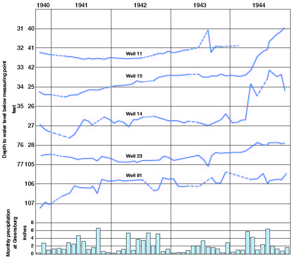
The water level in well 11 showed a net gain of 0.36 foot from October, 1940, to March, 1944, and wells 14, 15, 23, and 91, respectively showed net gains in water level of 1.80, 3.27, 0.65, and 1.82 feet from October, 1940 to December, 1944.The magnitude of the fluctuations of water level in these five observation wells for the period of record ranged from 1.23 to 3.53 feet and averaged 2.55 feet.
Prev Page--Formation Summary || Next Page--Recharge, Discharge
Kansas Geological Survey, Geology
Placed on web Feb. 4, 2008; originally published Feb. 1948.
Comments to webadmin@kgs.ku.edu
The URL for this page is http://www.kgs.ku.edu/General/Geology/Kiowa/05_gw.html