![]()
Prev Page--Ground Water Principles, Water Table || Next Page--Recovery, Utilization
Ground Water, continued
Ground-water Recharge
The foregoing discussion of water-level fluctuations shows that the amount of water in storage in the underground reservoir does not remain the same for any long period. There is visible evidence that water is continually being discharged from the underground reservoir through springs, seepage areas, and wells; and the addition of water to the ground-water reservoir is clearly indicated by the fact that the water levels in the observation wells rise in response to precipitation. If there were no additions to the underground reservoir the water levels would show only declines.
The addition of water to the underground reservoir is termed recharge and may be accomplished in several different ways. All ground water within a practical drilling depth beneath Kiowa County is derived from the water that falls as rain or snow either within the county or on near-by areas west of the county. A discussion of the source of the water in each of the principal water-bearing formations is given on the following pages.
Recharge of the Meade and Ogallala Formations
Because the lithology and water-bearing properties of the Meade and Ogallala formations are so nearly the same and because there is no barrier between the two, it seems best to consider them as a hydrologic unit. The Meade and Ogallala formations in Kiowa County are recharged by local precipitation, by seepage from streams, and by subsurface percolation from the west.
Recharge from local precipitation--A part of the precipitation that falls on the surface of Kiowa County recharges the Meade and Ogallala formations. The average annual precipitation in the county is about 22 inches, but, only a small percentage of this amount passes through the soil and reaches the zone of saturation. Of the total precipitation, part is lost by evaporation and transpiration, part leaves the county as runoff, and the remainder eventually finds its way to the underground reservoir.
The amount of water lost through evaporation into the air varies from one season to another, the rate of evaporation being highest in summer when temperatures are highest. In an average year most of the total precipitation in the county comes during the summer, when the rate of evaporation is greatest. It is reasonable to assume, therefore, that a large proportion of the annual precipitation in Kiowa County returns to the atmosphere through evaporation.
A part of the precipitation that falls is used by plants through the process of transpiration. The amount, consumed in this way is obviously greatest during the growing season, which closely coincides with the period of the maximum rainfall.
The amount of water leaving the county by runoff in streams is determined principally by the duration and intensity of the rainfall, the slope of the land surface, and the type of soil and vegetation. The runoff from a gentle rain as a rule is much smaller than the runoff from a heavy downpour; hence the amount of groundwater recharge from a gentle rain of long duration generally is greater than the recharge from a heavy downpour of short duration, providing all other factors are equal. The slope of the land is an important factor in determining the amount of runoff, and in general the steeper the slope the greater the runoff. Runoff is also greater in places where the surface is underlain by fine relatively impermeable material than in places where the surface material is sandy and loosely compacted. The latter type of material allows a part of the water to percolate into the ground, thus decreasing the amount. of surface runoff. Vegetation tends to decrease the velocity of the runoff, thereby offering a better opportunity for the water to seep into the ground.
The most favorable area for recharge of the Meade and Ogallala formations from precipitation is the sand hills. Because of the high porosity of the dune sand and the presence of many undrained basins that serve as catchment area for the rainfall, much water percolates downward to the zone of saturation. The sandy surficial material and the gentle slopes in this area reduce runoff to a minimum, so that very little water is lost by runoff in the sand hills except in a narrow belt along Rattlesnake Creek and its tributaries. Throughout most of this area the material between the land surface and the water table is sufficiently permeable to allow water to percolate downward with little interruption (see logs 1, 2, 4, 5, 6, and 9). In a few places lenses of relatively impermeable material probably hinder downward movement of water. Such lenses, however, are believed to be of limited horizontal extent so that the water probably detours around them and eventually reaches the water table.
The hydrographs of wells 15 and 23 in Figure 5 indicate that during periods of abundant rainfall a large amount of water is added to the Meade and Ogallala formations by precipitation in the sand hills. The rainfall as recorded at Greensburg was above average each year except 1943 for the period 1940 to 1944. As a result the water levels in wells 15 and 23 rose 3.27 and 0.65 feet, respectively, from October, 1940, to December, 1944.
If it is assumed that the porosity of the water-bearing materials within the zone of fluctuation of the water table is 20 percent, then each foot of rise in the water table would represent an addition of approximately 40 million gallons of water for each square mile. If the average net rise of the water table over the entire sand hills for this 4-year period was 1 foot, which probably is a conservative estimate, then the net addition to the underground reservoir during the 4 years would amount to 2.3 inches of water or about. 2.2 percent of the total precipitation. The amount of water discharged from the ground-water reservoir beneath the sand hills during this same period must be added to this to obtain the total amount of water added to the ground-water reservoir by recharge.
The amount of water that reaches the water table from precipitation on the upland plains probably is very small compared with the sand hills, for the upland plains are underlain by thick deposits of silt (Kingsdown) that transmits water very slowly. After heavy rains the broad shallow depressions in the uplands are filled with water that may remain for several days or weeks. Part of this water is evaporated ', but a part probably percolates downward. Although the soil forming the floor of such depressions has a fairly low permeability, the water has access to the soil for such a long period of time that a part of the water seeps downward and eventually reaches the water table.
Most of the area underlain by the Meade and Ogallala formations in the dissected area consists of moderate to steep slopes that favor high runoff and low ground-water recharge. Where coarse sands and gravels of the Meade formation are exposed at the surface and where the slopes are gentle, however, the amount of recharge from precipitation probably equals or exceeds that in the sand hills. These conditions exist in the upper divide areas between Haviland and Belvidere, where a large proportion of the water falling on the highly permeable sands and gravels percolates downward almost immediately. The amount of water added to the ground-water reservoir by this means is necessarily limited by the relatively small area in which these conditions exist.
Recharge from streams--The ridges on the water-table contour map (Pl. 1) indicate that along part of their courses West Fork of Rattlesnake Creek, Rattlesnake Creek, and East Fork of Rattlesnake Creek are losing water to the ground-water reservoir. The channels of these streams lie above the water table throughout Kiowa County, and the deposits beneath the channels in most places are sufficiently permeable to allow the water to percolate downward. During times of heavy rains these streams carry large volumes of water, a large part of which flows into Edwards County, though part of it seeps into the ground before reaching Edwards County. The magnitude and frequency of the water-level fluctuations in well 14 (Fig. 5), which is only a short distance west of West Fork of Rattlesnake Creek, indicate that the ground-water reservoir in the vicinity of this well is receiving water from the creek.
Although no evidence of recharge from other streams is apparent on the water-table contour map, it seems probable that some of the others also are supplying water to the underground reservoir. The channels of Turkey, Middle Kiowa, Wiggins, and East Kiowa Creeks in the southwestern part of the county and of Thompson, Spring, and Soldier Creeks in the east-central part of the county are above the water table in the upper part of their courses and below the water table in the lower part of their courses. These streams probably furnish a small amount of water to the ground-water reservoir where their channels lie above the water table, but where their channels lie below the water table v are receiving water from the ground-water reservoir (p. 44). The channel of Mule Creek is above the water table throughout Kiowa County and may lose water to the ground-water reservoir. The same is true of the extreme upper part of Medicine Lodge River.
Recharge from outside of county--The water-table contours on Plate 1 show that the ground water in this area is moving from west to east, indicating that water percolates into the Meade and Ogallala deposits of this area from Ford and Clark counties.
Recharge of the Dakota Formation
The Dakota formation in Kiowa County occurs beneath the Meade and Ogallala formations in an irregular belt about 10 miles wide that, extends northwestward from the south-central part of the county (Pl. 5). The regional dip of the Dakota formation is northeastward, therefore there probably is subsurface movement of water into the Dakota in the northeastern part of the county from the Dakota of Ford County. A part of this water probably migrates into the overlying Meade and Ogallala formations in places where the head of the water in the Dakota is greater than the head in the Meade and Ogallala.
Most of the Dakota formation cannot receive water from outside the county because it has been truncated by erosion in the southern and parts of the county; therefore it must derive its water largely from the Meade and Ogallala formations. Probably only a negligible amount is derived from precipitation on the small area of outcrop within the county (Pl. 1). Water in the Dakota probably returns to the Meade and Ogallala formations near the southeast and northwest edges of the formation.
Recharge of the Cheyenne Sandstone
The addition of water to the Cheyenne sandstone is achieved in at least three ways; (1) by water migrating from the Meade and Ogallala formations into the Cheyenne where they are in contact; (2) by recharge from local precipitation; and (3) by subsurface percolation from outside the county.
In the southwestern part of Kiowa County the Dakota formation and Kiowa shale were completely removed during the period of erosion that, preceded deposition of the Ogallala formation so that sediments of the Meade and Ogallala formations are in contact with the Cheyenne sandstone in this area (Pl. 5). Water in the Meade and Ogallala formations moves southward over the Cheyenne sandstone, and the water that migrates into the Cheyenne sandstone probably moves northeastward down the dip of the formation (Fig. 9).
The Cheyenne sandstone is exposed in southeastern Kiowa County and undoubtedly absorbs some water directly from the rains that fall on its outcrops. The amount of water added in this way is probably small, however, because the steepness of the slopes, the sparseness of the vegetation, and the relatively low permeability of the Cheyenne sandstone favor a high rate of runoff and a low rate of absorption.
A part of the water that enters the Cheyenne sandstone in other areas probably travels down the dip of the sandstone into Kiowa County, but the amount carried is limited by the low permeability of the sandstone. The Cheyenne is exposed in parts of Comanche and Clark counties where it probably absorbs some water directly from rainfall and from streams that cross the outcrops. Some water also may enter Kiowa County by subsurface percolation in the Cheyenne from Ford County.
Ground-water Discharge
General Features
Ground water is discharged from the underground reservoir in Kiowa County by springs and seepage areas, evaporation and transpiration, subsurface movement, from the county, and by wells.
Before any water was pumped from wells in Kiowa County, it is probable that. the annual discharge of ground water by natural processes was approximately equal to the annual recharge. Artificial discharge by pumping represents an additional amount of water taken from the ground-water reservoir without any increase in the amount of replenishment; hence the state of approximate equilibrium between annual recharge and annual discharge is disrupted. Approximate equilibrium is again attained by a gradual regional lowering of the water table until the natural discharge is decreased by an amount equal to the artificial discharge. The amount of water annually withdrawn from the ground-water reservoir in Kiowa County by pumping from wells is small compared with the natural discharge. Consequently only a slight adjustment of the water table probably was required to restore approximate equilibrium.
Springs and Seepage Areas
Character and distribution--Springs in Kiowa County are of two types: (1) seepage springs, in which the water percolates to the surface from numerous small openings in permeable material because the surface extends down to the water table; (2) contact springs, in which the water flows to the surface from permeable material over the outcrop of less permeable or impermeable material that prevents the ground water from percolating downward and deflects it to the surface. The term "seepage area" is used to denote any large area in which water is seeping to the surface at many points from permeable material (Pl. 6A). The distinction between these three types is somewhat arbitrary and each may grade into another. The term "spring" is restricted to individual and definite points of discharge where water can be seen flowing from the rocks. Although the discharge from any one point in a seepage area is not great enough to cause a surface flow of water, the aggregate discharge from a seepage area may result in a comparatively large surface flow.
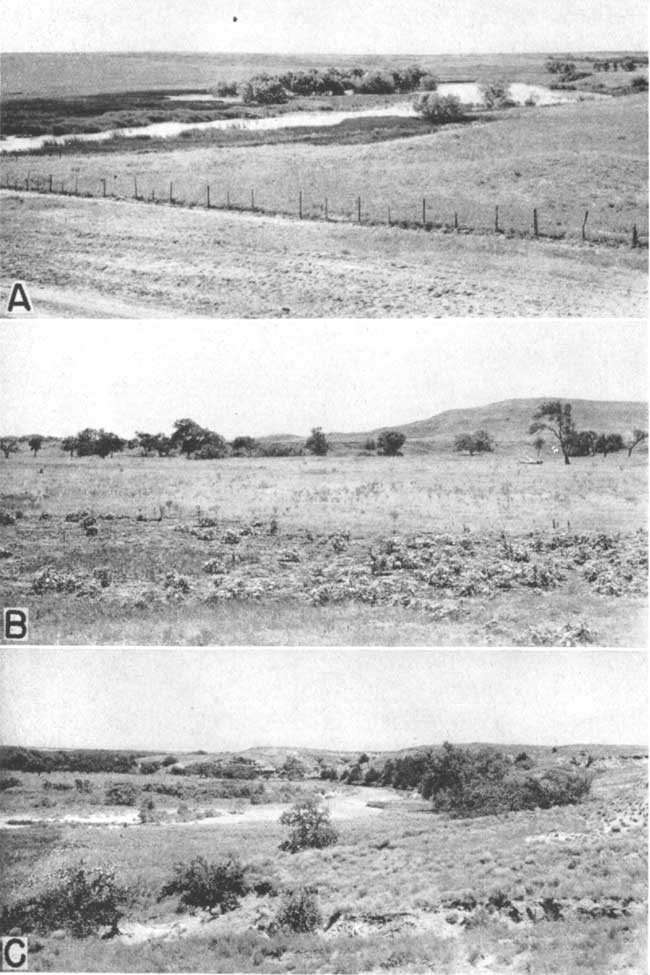
Plate 6--A, Seepage area near the head of Spring Creek in the NW NW sec. 15, T. 29 S., R. 16 W. (No. 1 in Fig. 6); the water is impounded behind a dam. B, Terraces along the south side of Medicine Lodge Valley abut 4 miles west of Belvidere; surface of lower terrace is in foreground and just beyond the trees may be seen the upper terrace. C, Medicine Lodge Valley is formed by Dog Creek shale (Permian).
The locations of most of the springs and seepage areas in Kiowa County are shown on Plate 2 and in Figure 6.
Descriptions of all springs and some of the seepage areas (by numbers shown in Fig. 6) visited in the county are given in Table 9, and chemical analyses of four samples of water collected from springs (6, 10, 16, and 18) are given in Table 5.
Fig. 6--Location of springs, seepage areas, and points where stream-flow measurements were made in southern Kiowa County. A larger version of this figure is available.
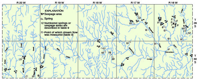
All of the springs and seepage areas occur in the dissected area in the southern part of the county, where many of the valleys have been cut below the water table. Most of the springs are along the sides of the main valleys, at or near the base of the valley bluffs, or at the head of tributary draws; the seepage areas are generally in the bottoms of the valleys or draws.
The springs along Soldier, Spring, and Thompson creeks (2-6, 9-14) are seepage springs whose waters flow from permeable sand and gravel of the Meade formation (Pleistocene). They were formed at places where valleys have been cut below the water table. The proximity of relatively impermeable shale (Kiowa) beneath the sands and gravels is a contributing factor in that it prevents the downward percolation of the ground water and deflects it to the surface. Spring 21 in Middle Kiowa Creek Valley, in the southwestern part of the county has a similar source and origin. The water at most of these springs percolates upward from the sand and gravel and forms small pools of water; at springs that have sufficiently large discharge, small surface flows occur.
Contact springs (15-20) are found along Medicine Lodge River Valley and in draws tributary to the Medicine Lodge in the south-central part of the county (Fig. 6). The water at springs 15, 19, and 20 issues from permeable sand of the Meade formation at the contact of the Meade and the underlying Kiowa shale. Springs 16, 17, and 18 occur at the base of a sandstone lens in the Kiowa shale that is underlain by relatively impermeable clay. The water issues from pore spaces in the sandstone or from small fractures or from both.
According to reports of local residents, numerous springs existed years ago along the outcrop of the Cheyenne sandstone south of Medicine Lodge Valley in T. 30 S., R. 16 W., but no springs were found in this area at the time the investigation was made in 1941. The recent series of dry years or clogging of the openings by silt may have caused the drying up of these springs.
Yield--The yields of most, of the springs in Kiowa County are relatively small, generally less than 5 gallons a minute. The largest known spring in the county is Greenleaf Spring (19) whose measured discharge in November 1941 was 130 gallons a minute. The second largest known spring is Thompson Creek Spring (13), near the head of Thompson Creek, whose measured discharge in November 1941 was 98 gallons a minute. Estimated discharges of some of the smaller springs are given in the table of spring records.
Although the yield of individual springs is relatively small, the aggregate yield of all the springs and seepage areas is rather large. Measurements of the flow of most of the streams fed by springs and seepage areas in the county were made in November, 1941 by Woodrow W. Wilson of the Federal Geological Survey and Melvin Scanlan of the Division of Water Resources, Kansas State Board of Agriculture, and are given in Table 3.
Table 3--Discharge measurements of spring-fed streams in Kiowa County, Kansas.1
| Letter on Fig. 6 |
Stream | Locality | Date of measurement |
Discharge (gallons a minute) |
Method of measurement2 |
|---|---|---|---|---|---|
| T. 29 S., R. 16 W. | |||||
| A | Soldier Creek | S2 sec. 35 | Nov. 5, 1941 | 1,723 | C |
| B3 | East Branch Spring Creek | S2 sec. 22 | 1940 | 1,580 | W |
| C | West Branch Spring Creek | NE sec. 29 | Nov. 5, 1941 | 1,167 | W |
| D | Spring Creek | S2 sec. 33 | Nov. 5, 1941 | 3,698 | C |
| T. 29 S., R. 17 W. | |||||
| E | Thompson Creek | NW sec. 25 | Nov. 5, 1941 | 5,009 | C |
| T. 30 S., R. 16 W. | |||||
| F | Thompson Creek | NW sec. 6 | Nov. 5, 1941 | 6,063 | C |
| T. 30 S., R. 20 W. | |||||
| G | East Kiowa Creek | SE sec. 36 | Nov. 4, 1941 | 382 | W |
| H | Wiggins Creek | SW sec. 36 | Nov. 4, 1941 | 54 | W |
| I | Middle Kiowa Creek | S2 sec. 34 | Nov. 4, 1941 | 1,176 | C |
| 1. Measured by W.W. Wilson, U.S. Geological Survey, and Melvin Scanlan, Division of Water Resources of Kansas State Board of Agriculture, unless otherwise noted. 2. C, current meter; W, wier 3. Measured by Charles Razeau, local resident |
|||||
The measured flow of the streams ranged from 54 gallons a minute for Wiggins Creek to 6,063 gallons a minute for Thompson Creek. The aggregate discharge of the streams measured amounts to about 19 million gallons a day, or nearly 7 billion gallons a year. These figures represent only a part of the total amount of ground water that is discharged from the underground reservoir by springs and seepage areas in the upper part of Medicine Lodge Valley, in Turkey Creek, and in two unnamed creeks in the southwestern corner of the county.
Transpiration and Evaporation
Transpiration is the process by which water is taken into the roots of plants directly from the zone of saturation or from the capillary fringe, and is discharged into the atmosphere. The depths from which plants will lift the ground water varies with different plant species and different types of soil. Ordinary grasses and field crops will not send their roots more than a few feet in their search for water, but alfalfa and certain desert plants may send their roots several tens of feet to reach the water table.
In Kiowa County the discharge of ground water by transpiration and evaporation is restricted to the valley areas where the water table is shallow. The greatest loss of ground water by these two processes occurs in the valley areas in the southeastern and southwestern parts of the county, where the water table is only a few feet below the land surface. Discharge by transpiration and evaporation is particularly high in areas where the water table intersects the land surface or where the capillary fringe extends to the surface. Such areas are rather common in the valleys of Soldier, Spring, Thompson, East Kiowa, Wiggins, Middle Kiowa, and Turkey creeks (Fig. 6), where springs, seepage areas, and marshy lands with abundant vegetation are characteristic. The vegetation includes plant species that habitually draw ground water, such as salt grass, reed grass, and cattails, and that are not found elsewhere in the county (Pl. 6A).
Some loss of ground water by transpiration and evaporation probably occurs in the valleys of West Fork of Rattlesnake, Rattlesnake, and East Fork of Rattlesnake Creeks in the northern part of the county. Transpiration and evaporation are confined almost exclusively to the channels of these ephemeral streams and to a narrow belt bordering the channels where the water table is very shallow.
The amount of ground water discharged annually by plant transpiration and evaporation in Kiowa County is not known, but in the areas described above the loss is thought to be rather large.
Wells
In 1941, there were 5 irrigation, 6 public-supply, 4 industrial, 1 railroad, 1 domestic and irrigation, and a large but unknown number of domestic and stock wells in the county. The amount of water annually discharged from the underground reservoir by wells is not known, but it probably is small compared with the amount discharged by natural processes. The recovery of ground water from wells is discussed in the following section.
Prev Page--Ground Water Principles, Water Table || Next Page--Recovery, Utilization
Kansas Geological Survey, Geology
Placed on web Feb. 4, 2008; originally published Feb. 1948.
Comments to webadmin@kgs.ku.edu
The URL for this page is http://www.kgs.ku.edu/General/Geology/Kiowa/05_gw2.html