![]()
Prev Page--Introduction || Next Page--Formation Summary
Geography
Topography and Drainage
Kiowa County is in the Plains Border section of the Great Plains physiographic province (Fenneman, 1931, Pl. 1). The highest point is the divide between Turkey Creek and the West Fork of Rattlesnake Creek at the western county line, where the altitude reaches about 2,440 feet. The lowest point--where Medicine Lodge River leaves the county--has an altitude of about 1,740 feet. The total relief in the county is therefore about 700 feet, although locally the relief does not exceed 300 feet.
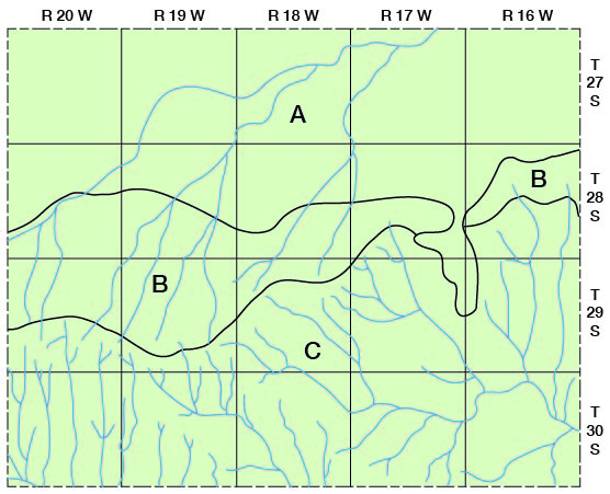
Kiowa County may be divided into three physiographic divisions which exhibit differences in topography, drainage, and origin (Fig. 2): the sand hills, the upland plains, and the dissected area.
Fig. 2--Physiographic divisions of Kiowa County: (A) sand hills; (B) upland plains; and (C) dissected area.
Sand hills
Approximately the northern third of Kiowa County is part of the large dune-covered area that lies south of the great bend in the Arkansas River and extends westward as a narrow belt bordering the south side of Arkansas Valley. The sand hills in Kiowa County are characterized by typical sand dune topography, having moderate slopes and hills separated by small basins. The maximum local relief of the sand hills is about 60 feet, and the average is only about 30 feet.
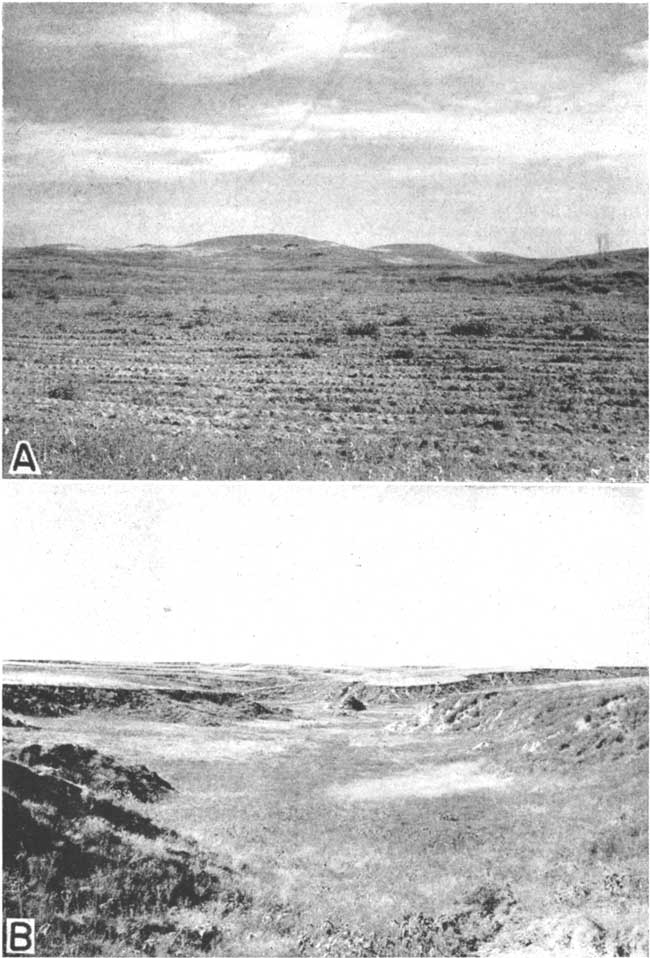
Most of the sand hill area is covered by vegetation and is thus protected from wind erosion, but in a few places there are small areas of bare sand that are subject to wind attacks (Pl. 3A.) Some parts of the sand hills are suited to cultivation but others are not, and much of the northwestern part of the area is used for raising cattle.
Plate 3--A, Sand hills south of Haviland, Kansas, looking north from the SW sec. 36, T. 28 S., R. 17 SW.; B, Characteristic erosion of the Kingsdown silt, looking southward from the head of East Kiowa Creek in the NW sec. 30, T. 29 S., R. 19 W.
The central and western parts of the sand hills are partly drained by Rattlesnake Creek and its tributaries (Pl. 1), but the greater part of this area has no surface drainage. Instead of running off the rainfall collects in the numerous basins and hollows where most of it seeps into the ground and the rest is evaporated. The relationship of the sand hills to ground-water recharge is discussed on page 39.
Upland plains
The upland plains division comprises an east-west belt about 2 to 8 miles wide across the central part of the county (Fig. 2). It is bounded on the north by the sand hills and on the south by the dissected area. The boundary between the upland plains and the dissected area is rather indistinct.
The upland plains are the remnants of a once extensive plain that extended over all or nearly all of Kiowa County. The plains are characterized by gentle to moderate slopes in the west and by a nearly flat to gently rolling surface in the east. Although erosion of the soft Kingsdown silt by streams (Pl. 3B) has modified much of the area, some remnants of the original plain are still preserved.
Dissected area
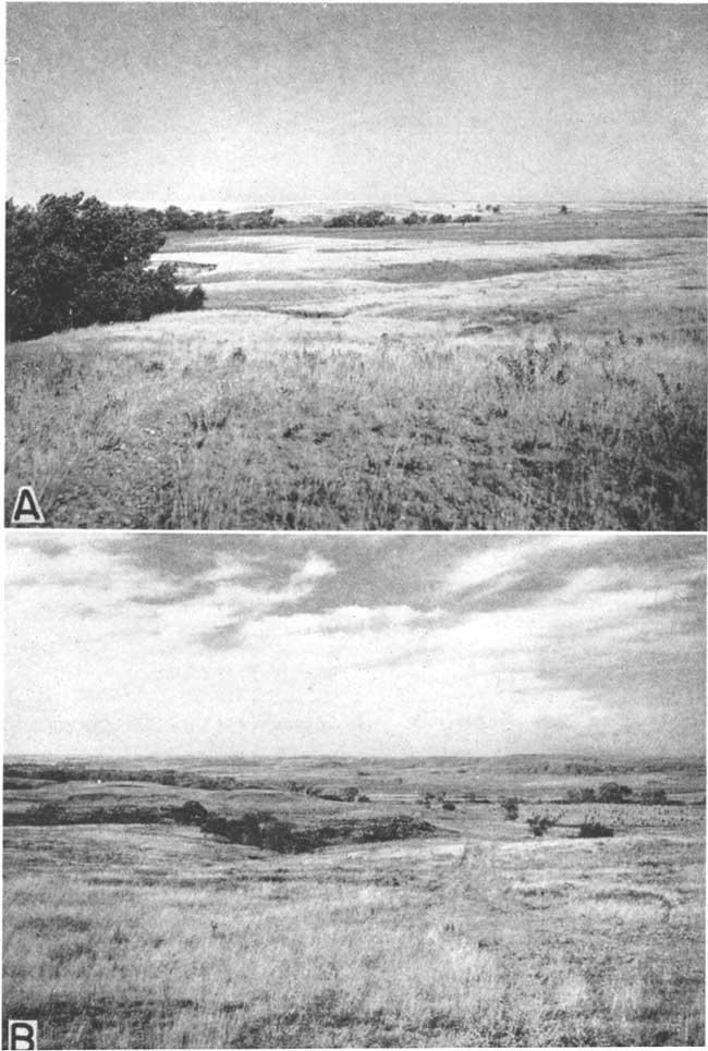
The dissected area comprises all of Kiowa County south of the upland plains (Fig. 2). The surface of this area was at one time continuous with that of the upland plains but has been deeply dissected by stream erosion. Erosion in the east has cut below the Quaternary and Tertiary silts, sands, and gravels and has exposed a large area of shales and sandstones of Cretaceous and Permian age (Pl. 1). These rocks have also been exposed in two small areas in the southwestern part of the area. Dissection has resulted in a rugged topography having a local relief of approximately 300 feet. In the north where the streams have not yet cut into the more resistant, rocks, the slopes are gentle to moderate (Pl. 4A), but in the south where erosion exposed "mortar beds" or sandstone the slopes are moderate to very steep (Pl. 4B). The Kiowa shale generally forms moderate slopes except where it is capped by "mortar beds" or sandstone.
Plate 4--Thompson Creek Valley. A, Spring area near the head of Thompson Creek in the NW sec. 10, T. 29 S., R. 17 W.; B, View looking southwest across Thompson Creek Valley from the middle of sec. 6, T. 30 S., R. 16 W. The bluffs are formed by Kiowa shale.
Drainage basins
Kiowa County is in three drainage basins: upper Arkansas, lower Arkansas, and Cimarron. Approximately the northern half of the county is in the upper Arkansas drainage basin and is drained by Rattlesnake Creek and its tributaries (Pl. 1). After leaving Kiowa County, Rattlesnake Creek flows in a general northeasterly direction and empties into Arkansas River in southwestern Rice County. Throughout its course in Kiowa County, Rattlesnake Creek is an ephemeral stream--that is, it flows only in response to local rains. The southeastern and south-central parts of the county are in the lower Arkansas drainage basin and are drained by Medicine Lodge River and Mule Creek. Mule Creek is an ephemeral stream that heads in south-central Kiowa County, flows southeastward, and joins the Salt Fork of Arkansas River in southwestern Barber County. Medicine Lodge River also heads in south-central Kiowa County, flows in an easterly direction through the county, and empties into the Salt Fork of Arkansas river in northern Oklahoma. Medicine Lodge River has three main tributaries in this area--Thompson Creek, Spring Creek, and Soldier Creek, all of which enter from the north. Medicine Lodge River and its major tributaries are perennial streams fed by ground water.
The southwestern part of Kiowa County is in the Cimarron drainage basin and is drained by the following tributaries of Sand Creek: Turkey Creek, Middle Kiowa Creek, Wiggins Creek, and East Kiowa Creek, all of which are ephemeral in their upper courses but perennial in their lower courses in Kiowa County. Sand Creek is a perennial stream that flows across the extreme southwestern corner of Kiowa County and joins Bluff Creek in west-central Comanche County, which in turn flows into Cimarron River in southwestern Comanche County.
Population
The 1940 census gives the population of Kiowa County as 5,112, an average of 7.1 inhabitants per mile [Note, Kiowa County population was 3,278 in 2000 U.S. Census, with a population per square mile of 4.5 (KU Institute for Policy & Social Research).]. Greensburg, the county seat and largest city, had a population of 1,417 (1,574 in 2000); Haviland, 499 (612 in 2000); Mullinville, 428 (279 in 2000); and Wellsford, 64. Population figures are not available for the small communities of Belvidere, Joy, and Brenham.
Transportation
The main line of the Chicago, Rock Island and Pacific Railroad crosses Kiowa County from east to west passing through all towns in the county with the exception of Belvidere. Belvidere is served by a branch line of the Atchison, Topeka and Santa Fe Railway, which crosses the southeastern corner of the county.
Most of the county is covered by a network of modern highways and improved secondary roads. U. S. highway 54 passes from east to west through the central part of the county. U. S. highway 154 comes from the southwest and joins highway 54 a mile east of Mullinville. Kansas highway 1 crosses the county from north to south passing 1 mile west of Greensburg. These highways are all oil-surfaced. Many of the county roads are graveled and are kept in good condition throughout the year. Many of the section roads are graded except in the northwestern, southwestern, and southeastern parts of the county (Pl. 1).
Agriculture
The principal occupations in Kiowa County are farming and stock raising. Much of the land in the southwestern and southeastern parts of the county is covered with native buffalo, grass and used for stock raising. Most of the rest of the county is under cultivation by dry-farming methods. In 1940 there were 735 farms in Kiowa County, averaging 608.5 acres in size (16th U. S. census, 1940). There were 108,515 acres of wheat harvested in the county, 11,803 acres of sorghums, 3,964 acres of barley, 3,720 acres of corn, 3,672 acres of rye, and 380 acres of hay. In 1939 only 278 acres of land in Kiowa County were irrigated.
Climate
The climate of Kiowa County is of the subhumid to semiarid type, involving slight to moderate precipitation, abundant sunshine, moderately high average wind velocity, and rapid evaporation. Although summer days are hot, the heat is alleviated somewhat by good wind movement. The winters are moderate with occasional severe cold periods of short duration. There is relatively little snowfall.
The mean annual temperature at Greensburg is 56° F. The mean monthly temperatures in summer are 73.9° F for June, 79.4° F for July, and 78.4° F for August. The mean monthly temperatures for January and December, generally the coldest months, are 32.4° F and 33.9° F, respectively. The average growing season--the average interval between the last killing frost, in the spring and the first killing frost in the fall--is 183 clays, and has ranged from 151 to 224 days.
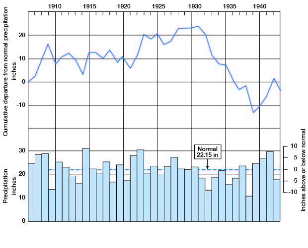
The mean annual precipitation at Greensburg is 22.15 inches. Deviations from the mean, however, are frequent and extreme. The recorded annual precipitation ranges from a minimum of 10.51 inches in 1939 to a maximum of 31.33 inches in 1915. About 75 percent of the annual precipitation falls during the crop-growing season from April through September (Fig. 3).
Fig. 3--Monthly distributions of normal minimum and maximum rainfall at Greensburg.
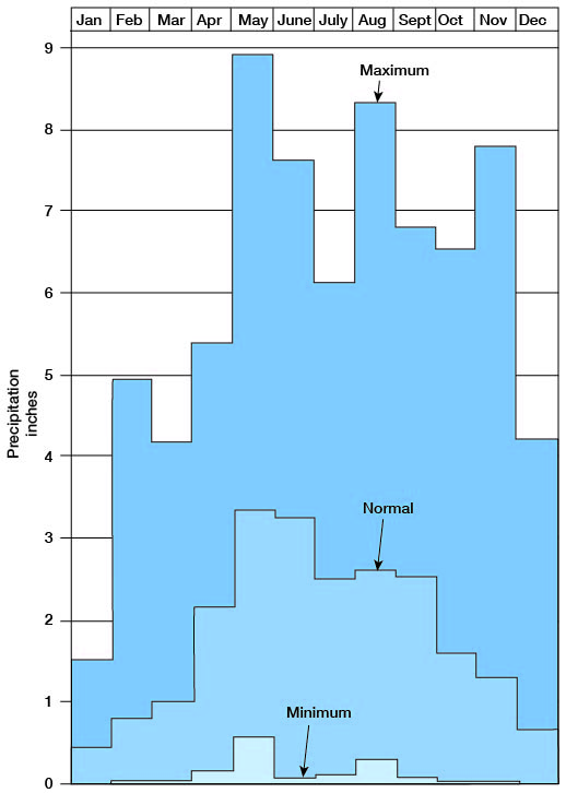
Normal precipitation during May and June, the wettest months, is about 6.59 inches, or about 28 percent of the annual total; during January and December, the driest months, it is only about 1.1 inches, or about 5 percent of the annual total.
Precipitation in Kiowa County seems to follow more or less irregular cycles in which wet periods alternate with dry periods. Since 1907, when rainfall records were started at Greensburg, there have been 17 years of above-normal rainfall and 20 years of deficient rainfall. The annual precipitation and the cumulative departure from normal precipitation at Greensburg are shown graphically in Figure 4.
Fig. 4--Annual precipitation and cumulative departure from normal precipitation at Greensburg, Kiowa County, Kansas. (From records of U. S. Weather Bureau.)
Prev Page--Introduction || Next Page--Formation Summary
Kansas Geological Survey, Geology
Placed on web Feb. 4, 2008; originally published Feb. 1948.
Comments to webadmin@kgs.ku.edu
The URL for this page is http://www.kgs.ku.edu/General/Geology/Kiowa/03_geog.html