![]()
Prev Page--Chemical Character || Next Page--History
Water-bearing Characteristics of Rock Formations
The quantity of water that a rock formation will yield to wells depends on the lithology, structure, thickness, and distribution of the formation. The quality of water that a formation yields depends largely on the kind of minerals in the rocks. Rocks containing large amounts of soluble minerals, such as salt and gypsum, generally yield water that is highly mineralized whereas rocks composed chiefly of quartz or other relatively insoluble minerals generally yield water that has a low concentration of dissolved mineral matter. The various rock formations in Kiowa County differ widely in the amount and quality of water they yield. Sand and gravel beds of the Ogallala and Meade formations are the principal source of ground water in the county and yield moderate to large supplies of good quality water to wells and springs. Alluvium in the large valleys in the southern part of the county is capable of furnishing small to moderate supplies of water, but in many places the water is very hard. The Kingsdown silt and dune sand lie above the water table everywhere in Kiowa County and are therefore unimportant as water-bearing formations. The Cretaceous and Permian rocks are poor water bearers in Kiowa County. The Kiowa shale and Cheyenne sandstone of Cretaceous age and Whitehorse sandstone and Flowerpot shale of Permian age furnish small supplies of water to a few wells in the southern part of the county, but in most places the water from these formations is highly mineralized. In some localities the water is too highly mineralized for ordinary purposes.
Following are detailed descriptions of each formation, giving the lithologic character, thickness, distribution, and the quality and quantity of water that they yield. The formations are discussed in the order in which they were laid down, from the oldest to the youngest.
Permian System
Excellent reviews of early work on the Permian rocks of southern Kansas have been given by Prosser (1897, pp. 75-83,) and Knight (1929, pp. 80-98). For many years the redbeds of southern Kansas were assigned by various authors to the Dakota sandstone, Triassic, or Jura-Trias. Hay (1893, p. 101) correlated the redbeds in Kansas with similar rocks in northern Texas and placed them in the Permian. Cragin (1896, pp. 2-5) named and described the redbeds and subdivided them into ten formations. Although a few important changes have been made, his classification serves as a basis for that now in use. The classification followed in this report is that, in use by the Kansas Geological Survey (Moore, Frye, and Jewett, 1944, pp. 157, 158) and differs somewhat from other classifications. One of the most comprehensive of recent reports on the Permian redbeds of Kansas is that by Norton (1939).
Permian redbeds are exposed in two small areas along Wiggins and East Kiowa Creeks in the southwestern part of Kiowa County and in a larger area along Medicine Lodge River and its tributaries in the southeastern part of the county (Pl. 1). From the areas of outcrop the dip beneath younger sediments and are found beneath the surface everywhere in the county. Only part of the Blaine formation, Dog, Creek shale, and Whitehorse sandstone are exposed at the surface and it is unlikely that any Permian beds younger than the Whitehorse are present anywhere in the county. The Taloga formation, Day Creek dolomite, and upper part of the Whitehorse sandstone were removed during the time of erosion that followed Permian deposition, and beds down to the Medicine Lodge gypsum member of the Blaine formation were removed in the southeastern corner of the county during later times of erosion.
Flowerpot Shale
General features--The Flowerpot shale was differentiated as a formation by Cragin (1896, p. 24), who named it from Flowerpot Mound southwest of Medicine Lodge at the divide between East Cedar and West Cedar Creeks in Barber County. It includes all strata from the top of the Cedar Hills sandstone to the base of the lower gypsum bed (Medicine Lodge gypsum member) of the Blaine formation. The outcrop area of the Flowerpot in Kansas is confined to the western half of Barber County and the southeastern part of Comanche County. It is not exposed in Kiowa County but underlies the southeastern part at relatively shallow depths.
At the type locality in Barber County the Flowerpot consists of dark red-brown to reddish-purple shale and many thin and a few thick beds of sandstone (Knight, 1929, p. 69; Norton, 1939, p. 1,792). Gypsum is common in the formation and occurs as a cement in many of the sandstones and in a network of veins in the shale. The gypsum-cemented beds of sandstone occur in most parts of the formation, but are most common near the top. A thin lentil of dolomite occurs near the middle of the formation. The vein material in the Flowerpot probably was deposited by percolating ground water that was heavily charged with calcium sulfate and other minerals. Beds of gypsum, dolomite, and anhydrite (Blaine formation) that overlie the Flowerpot shale probably were the source of the vein material. According to Norton (1939, p. 1,792), the amount of selenite veining commonly varies in the subsurface, and in some places rock salt is found at the horizon of the Flowerpot.
The thickness of the Flowerpot shale in Kiowa County is not known, but it probably is somewhat less than 200 feet. It is reported to be 173 feet thick at Lake City in northwestern Barber County (Knight, 1929 p. 70) and 190 feet thick southwest of Medicine Lodge (Norton, 1939, p. 1,792).
Water supply--Because of the low permeability of the materials making up the Flowerpot shale and because the water from the formation is so highly mineralized, it is unimportant as a source of ground water. Well 55 is the only well visited in Kiowa County that taps the Flowerpot shale. An analysis of the water from this well is given in Table 5 and is shown graphically in Figure 7. Chemically, the water from well 55 was one of the poorest of those sampled in the county. It contained 4,692 parts per million of dissolved solids, 1,548 parts of sodium and potassium, 1,722 parts of sulfate, 1,210 parts of chloride, and had a hardness of 308 parts.
Blaine Formation
General features--In his original classification, Cragin (1896, pp. 2-5) called the gypsum-bearing beds between the top of the Flowerpot shale and the base of the Dog Creek shale the Cave Creek gypsums and divided the formation into three members--the Medicine Lodge gypsum at the bottom separated from the overlying Shimer gypsum by the Jenkins shale. Gould (1902, pp. 42, 47) introduced the name Blaine for this sequence of beds, taking the name from Blaine County, Oklahoma, and the term Blaine is now generally accepted because of wide usage.
The Blaine formation as defined by the Kansas Geological Survey (Moore, Frye, and Jewett, 1944, p. 158) includes four members which are, in ascending order, the Medicine Lodge gypsum, Nesaatunga gypsum, Shimer gypsum, and the Haskew gypsum. All four gypsum members are present in southern Kansas and northern Oklahoma, but in the Medicine Lodge River drainage basin in Barber and Kiowa Counties only the Medicine Lodge member remains. According to Norton (1939, p. 1,798), slumpage in overlying beds is evidence of the wasting away by solution of beds that were at one time present in this area.
Medicine Lodge gypsum member--The rocks that make up the Medicine Lodge gypsum member of the Blaine formation are the oldest rocks exposed in Kiowa County. Outcrops of this member occur at or near the base of the bluffs that border Medicine Lodge Valley at the eastern edge of the county (Pl. 1). Less than 5 feet of the member is exposed in this area. The gypsum is white'-on a fresh surface but light gray when weathered, and is massive. Westward the gypsum passes beneath younger sediments and lies several hundred feet below the surface in other parts of Kiowa County.. An oil test drilled in the SE cor. SW1/4 sec. 25, T. 30 S.1 R. 17 W., encountered 22 feet of gypsum (Medicine Lodge) between depths of 320 and 342 feet (log 26).
The Medicine Lodge gypsum member is best developed southwest of Sun City in Barber County, where it is mined and used in making Keene's cement. A thin bed of gray to buff granular dolomite occurs at the base of the member throughout most of this area of outcrop in Barber County and is separated from the overlying gypsum by a thin bed of greenish shale (Knight, 1929, p. 71). The gypsum is relatively pure and is white to gray. In the lower part it is coarsely crystalline and contains clusters of selenite crystals. The texture of the gypsum is progressively finer and the color lighter from the bottom to the top of the member. The average thickness of the Medicine Lodge in Barber County is 21 to 25 feet. Because of its solubility, numerous caves and solution channels have been developed in the gypsum.
The Medicine Lodge gypsum member does not supply water to any wells in Kiowa County. Water probably could be found in joints and solution openings in the gypsum, but it would be too highly mineralized for ordinary purposes.
Dog Creek Shale
The Dog Creek shale was named by Cragin (1896, p. 39) from exposures on Dog Creek south of Lake City, Barber County. Cragin gave the Dog Creek shale the rank of a formation and it has been used in that sense by most geologists. Norton (1939, p. 1801) followed Cragin's definition of the Dog Creek shale, but qualified it by stating that:
In few places in the subsurface, can the Dog Creek shale be distinguished from the beds of the underlying Blaine because of the increase in gypsum content of the Dog Creek. Actually the Blaine-Dog Creek is a single gypsiferous formation both at the surface and underground, in Kansas, either one thickening at the expense of the other depending on the presence or prior removal of anhydrite or gypsum.
In the past the Kansas Geological Survey classified the Dog Creek shale as the uppermost member of the Blaine formation (Moore, 1940, p. 42), but in the most recent classification (Moore, Frye, and Jewett, 1944, p. 15S) the Dog Creek shale is given formational rank.
The Dog Creek shale includes the strata from the base of the Whitehorse sandstone to the top of the Medicine Lodge gypsum member of the Blaine formation. In Kiowa County the Dog Creek (see measured section 6, page 120) is composed chiefly of red shale but contains some sandstone and dolomite. The sandstone occurs in thin beds generally less than 2 feet in thickness, is fine-grained, and is light gray or mottled red and light gray. A bed of gray shaly dolomite about 1.5 feet thick occurs in the lower part of the formation. According to Knight (1929) the Dog Creek shale contains several thin beds of impure granular dolomite throughout most of the area of outcrop in Barber County, but in places in the northwestern part of the county the dolomites are absent and at about the same stratigraphic positions thin beds of gypsiferous sandstone occur.
The Dog Creek shale is exposed in narrow bands along the sides of Medicine Lodge Valley in the southeastern corner of Kiowa County, and it is present beneath younger rocks in all other parts of the county. Where exposed the Dog Creek forms gentle slopes that rise above the more resistant ledges of the Medicine Lodge gypsum member of the Blaine. The thickness of the Dog Creek shale in this area probably does not exceed 50 feet. At the type locality on Dog Creek in Barber County it is 53 feet thick, but in the southern part of Barber County near the Kansas-Oklahoma line it is only 14 feet thick (Norton, 1939, P. 1,799).
Except for the thin beds of sandstone, the materials of the Dog Creek are relatively impermeable and would yield little or no water to wells. No wells are known to obtain water from these rocks in Kiowa County.
Whitehorse Sandstone
General features--The uppermost Permian beds in Kiowa County belong to the Whitehorse sandstone. They seem to be conformable on beds of the Dog Creek shale, but this is in doubt. Many geologists conclude that the two are conformable, whereas others working in Oklahoma contend there is evidence suggesting a major unconformity at the horizon. Neither Knight (1929, p. 86) nor Norton (1939, pp. 1,802-1,803) found any evidence of an unconformity at the base of the Whitehorse in the southern Kansas area. In Kiowa County the Whitehorse sandstone is unconformably overlain by the Cheyenne sandstone (Comanchean) or, locally, by the Meade formation (Pleistocene).
The Whitehorse sandstone is exposed along Medicine Lodge Valley in the southeastern part of Kiowa County and in two small areas along Wiggins and East Kiowa Creeks in the southwestern part of the county (Pl. 1). Only the lower part of the sandstone is represented by exposures in the southeastern area. Here the Whitehorse is composted of red poorly bedded fine-grained friable sandstone and siltstone containing only minor amounts of shale. Although red is the dominant color, a light-gray to white zone near the top occurs in some places, and it is especially prominent on the south side of Medicine Lodge Valley about 1.5 miles southeast of Belvidere where the lower bluffs are composed of Whitehorse sandstone. Sandstones of the Whitehorse form relatively steep-sided canyons and massive bluffs. The total thickness of the Whitehorse sandstone in southern Kansas is somewhat less than 300 feet, but only the lower 50 or 60 feet is present in southeastern Kiowa County, and less than 10 feet is exposed in the two small areas in the southwestern part of the county. The outcrop along East Kiowa Creek (Pl. 7B) is composed of red fine-grained silty sandstone and red silty and sandy shale and represents a higher horizon in the Whitehorse sandstone than do the outcrops in the southeastern part of the county.
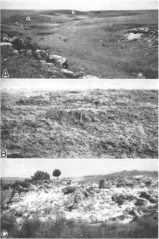
Plate 7--A, "Mortar beds" of the Ogallala formation in the NW SW sec. 25, T. 29 S., R. 18 W. B, Redbeds of the Whitehorse sandstone (Permian) unconformably overlain by the Meade formation (Pleistocene); exposure is on the east side of East Kiowa Creek in the SW sec. 31, T. 30 S., R. 19 W. (See measured section 17.)
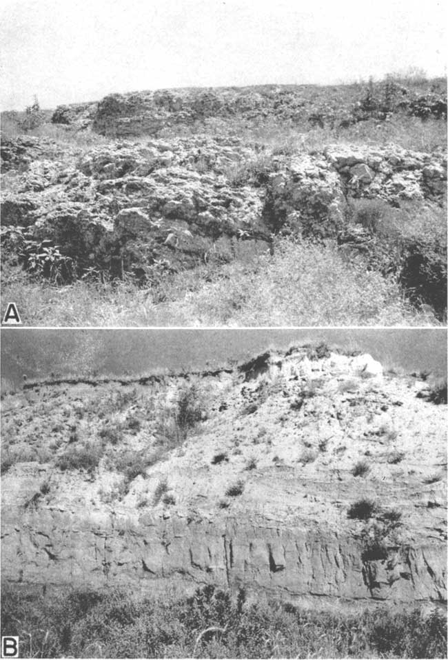
Fig. 7--Analyses of water from the principal water-bearing formations in Kiowa County.
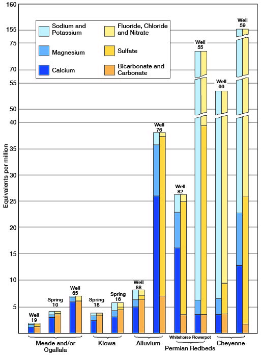
Water supply--The Whitehorse sandstone yields small quantities of very hard water to a few wells (74, 81, and 82) in southeastern Kiowa County. An analysis of a sample of water from well 82 is given in Table 4 and is shown graphically in Figure 7. The water is a hard calcium sulfate water that contained 1,694 parts per million of total solids, 321 parts of calcium, and 1,032 parts of sulfate and had hardness of 1,142 parts.
Cretaceous System
The stratigraphy of the rocks lying beneath the Graneros shale and above the Permian redbeds in Kansas and adjacent areas has been studied by numerous geologists for many years. Although the character of these sediments is fairly well known, their relationship to one another and hence their proper classification has been a matter of controversy. Southeastern Kiowa County is the type area for the lower part (Comanchean series) of these Cretaceous rocks as developed in Kansas, inasmuch as the type localities for 17 group, formation, and member names are located within this area. Only two of the 17 names, however, have come into general use--the Cheyenne sandstone and the Kiowa shale, which together comprise all of the Comanchean series of Kansas. The development of the present classification of the Cretaceous rocks of southern Kansas will be discussed in detail in a report to be published by the State Geological Survey of Kansas.
The Cretaceous rocks of Kiowa County have been subdivided in this report according to the present classification of the State Geological Survey of Kansas.
Comanchean Series
Cheyenne Sandstone
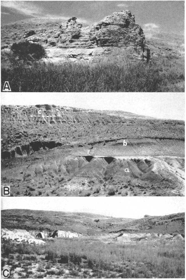
Character--The Cheyenne sandstone was named by Cragin (1889, p. 65) in 1889 from Cheyenne Rock--an indurated mass of this sandstone that forms a prominent ledge on the north side of Medicine Lodge Valley about three-fourths of a mile west of Belvidere (Pl. 8A). A short distance west of Cheyenne Rock is another prominent ledge of sandstone called Osage Rock. According to tradition this locality was the scene of a famous battle between the Cheyenne and Osage Indians.
The Cheyenne sandstone unconformably overlies the eroded surface of the Permian Whitehorse sandstone in this area and is conformably overlain by the Kiowa shale. The upper contact in most places is sharply defined and abrupt, although Moore (in Twenhofel, 1924, fn., p. 21) believes there is evidence, at least locally, of an unconformity.
Plate 8--A, Prominent ledge of Cheyenne sandstone known as Cheyenne Rock, from which the Cheyenne received its name. Cheyenne-Permian contact is concealed by weeds in foreground. Kiowa shale forms rounded hill in background. North bluff of Medicine Lodge Valley about three-quarters of a mile west of Belvidere. B, Exposure of Cheyenne sandstone (a), Kiowa shale (b), and Meade formation (c), in the NE sec. 5, T. 30 S., R. 16 W., about 1 1/4 miles north of Belvidere. The light colored ledge at the top of the bluff is volcanic ash in the Meade formation. C, Cheyenne sandstone and Kiowa shale in Champion draw. The thin bed in the middle of the picture is the shell limestone ("Champion shell-bed") at the base of the Kiowa. Note how the top of the Cheyenne grades laterally from light-colored sandstone (at left) into dark-colored sandy shale (at right).
The Cheyenne sandstone consists chiefly of light-colored fine- to medium-grained friable cross-bedded sandstone and lenses of sandy shale and conglomerate. A zone of pebbles and cobbles occurs locally at the base and minor amounts of clay, selenite crystals, iron nodules, and pyrite occur in different parts of the formation. The bedding is extremely irregular and discontinuous, making it impossible to trace any one bed for more than a short distance (Pls. 8A, 8C, and 9A). Most of the beds are merely small lenses.
Sandstone is the dominant type of rock in the Cheyenne. The most common colors of the sandstone are white, light gray, and tan, but in some places iron staining has produced beautiful shades of yellow, red, purple, and brown along bedding and lamination planes or in irregular splotches. The brightly colored zones are most common in the upper half of the formation. The-texture of the sandstone ranges from flour-like material of silt and clay size to fine gravel, but fine- to medium-grained sandstone is most common. The degree of assortment varies from one part of the formation to another and from one locality to another, but in general the material is well sorted. Quartz grains comprise the greater part of the sandstone although minor amounts of other minerals are also present. Pyrite and small pellets or concretions of limonite are locally present in the sandstone. Where present, pyrite is generally found near the top of the formation, and limonite concretions, which are small and of irregular shapes, are more common in the lower part.
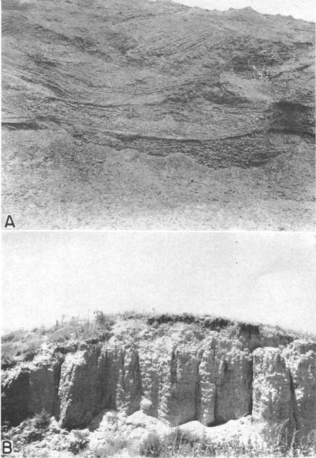
Plate 9--Exposure of the Cheyenne sandstone in the SW sec. 26, T. 30 S., R. 16 W. A, Massive sandstone containing thin lenses of sandy shale (see measured section 8a). B, Part of thick lens of conglomerate overlain by massive fine- to medium-grained sandstone (see measured section 8).
The sandstone as a whole is loosely cemented and is therefore easily eroded, but there are hard zones or layers that resist erosion. Cragin (1895, p. 361) and Twenhofel (1924, p. 15) report the occurrence of lenses or zones, of quartzite in the Cheyenne sandstone. Differential erosion of the hard and soft layers by rain wash, running water, and wind has produced many fantastic and oddly shaped forms in the sandstone. Buttes, badland areas, steep-walled canyons, box canyons, high steep-sided ledges, overhanging cliffs, "chimney-rocks," "pulpit rocks," and many other forms may be seen in the outcrop area of the Cheyenne sandstone (Pls. 8A, 9A, and 10C), many of which have been given names. Several of the badland areas, such as that shown in Plate 10C, are known as Hell's Half Acre. The most widely known area by this name in Kansas is in the northeastern corner of Comanche County. The name Natural Corral has been applied to a box canyon in the middle of sec. 36, T. 30 S.7 R. 16 W. Another well-developed but unnamed box canyon occurs in the SE sec. 9, T. 30 S., R. 16 W. Both of these box canyons have been used in the past as corrals by putting a fence across the open end. The prominent ledges of sandstone west of Belvidere, to which the names Cheyenne Rock and Osage Rock have been given, have been mentioned.
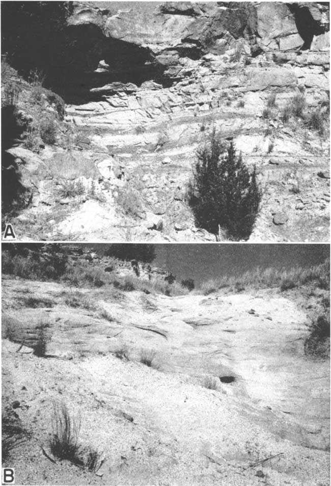
Plate 10--A, The Dakota formation (a, Gould's Kirby clays; b, Cragin's Reeder sandstone) at the head of Spring draw in the SE sec. 4, T. 30 S., R. 18 W.; in the foreground are "mortar beds" of the Ogallala formation. B, Hard, iron-cemented sandstone of the Dakota formation; type locality of Cragin's Reeder sandstone; exposure is at the head of Spring draw opposite "b" in the above photograph. C, Small badland area in the SW sec. 22, T. 30 S., R. 16 W., produced by differential erosion of the Cheyenne sandstone.
Lenses of pebble conglomerate were found at or near the base of the Cheyenne sandstone at nearly every exposure examined in Kiowa County (see measured sections 3, 4, 5, 8, 8a, and 11). The conglomerate is poorly cemented and consists of pebbles of red, gray, and clear quartz and weathered white to gray chert in a matrix of fine to coarse quartz sand. The abundance of white chert causes the conglomerate to appear white when viewed from a distance. Most of the chert pebbles are subangular to subrounded, but a few are well rounded; the quartz pebbles are subrounded to well rounded. The pebbles range in size from about 2 mm to about 10 mm in diameter. Most of the lenses of conglomerate range from only a few inches to 1 foot in thickness. The thickest section was found in the SW sec. 26, T. 30 S., R. 16 W., where 45.5 feet of conglomerate was measured at the base of the Cheyenne (Pl. 9B and measured section 8). At this same locality pockets of conglomerate were found immediately below the Permian-Cheyenne contact in what appear to be pot holes in the Permian.
A thin zone of well-rounded pebbles and cobbles occurs locally at the base of the Cheyenne sandstone in Champion draw about one-half mile south of Belvidere. The pebbles are from 1 to 3 inches in diameter, are composed of gray and pink quartzite, quartz, and chert, and are embedded in a matrix of gray to yellow-tan medium sand. Some of the chert pebbles have weathered into soft gray to white granular masses that may be easily broken by hand. A similar zone of pebbles and cobbles occurs in some places at the Permian-Cretaceous contact in central and northern Kansas. Charles C. Williams (personal communication) has observed this zone in western McPherson County where it occurs at the contact between the Permian beds and the Kiowa shale, and Plummer and Romary (1942, p. 320) report its occurrence at the contact between the Permian beds and the Dakota formation in northern Clay County.
Thick lenses of gray to black sandy and silty carbonaceous shale are common in the upper part of the Cheyenne sandstone, and thinner lenses of shale are found near the base. In some places the upper 5 to 16 feet consists almost entirely of shale, which if traced laterally will be found to grade into sandstone (Pl. 8C). Remains of fossil plants, lignite, and selenite crystals are common in the shales in the upper part of the formation.
Clay was found in the Cheyenne sandstone at only one locality in Kiowa County--in the NE sec. 12, T. 30 S., R. 16 W. (measured section 5), where thin beds and lenses of dark-red sandy and silty clay occur in the sandstone about 14 or 15 feet below the top of the formation.
The Cheyenne is identified in well logs by the predominance of sandy beds (logs 1, 6, 15, 16, 18, and 19)., The beds of sandstone generally are light gray to, white or brown. Interbedded with the sandstone are thinner beds or lenses of gray to black sandy shale. Gypsum, pyrite, and fossil charcoal were found in abundance in the samples from test hole 1 (log 1), but were not found in samples from the other test holes. A 6-foot bed or lens of gray to white conglomerate was encountered in test hole 19 (log 19), and sandy siltstone or very fine-grained sandstone was encountered at the base of the Cheyenne in test holes 1 and 19 (logs 1 and 19).
Mechanical analyses--The degree of sorting of a sandstone or other granular rock is determined by mechanical analysis, which consists of separating the mineral grains according to size by means of sieves and determining what percent, by weight, each size constitutes. Mechanical analyses of 18 samples of Cheyenne sandstone from Kiowa County have been made and are shown graphically in Figure 8 as histograms. The source of each sample is given in Table 7. Samples 1 to 14 were collected and analyzed by Ada Swineford and Harold Williams of the State Geological Survey of Kansas in connection with an investigation of the Cheyenne sandstone and associated formations in a part of Russell County, Kansas; samples 15 to 18 were collected by me. Laurence P. Buck made the mechanical analyses of samples 15, 16, and 17 and Swineford and Williams analyzed sample 18. Carefully weighed parts of each sample were put into a set of standard sieves, the sieves were then subjected to vigorous shaking, and the fractions were weighed on a precision balance. The samples analyzed by Swineford and Williams were shaken for 10 minutes in a Rotap shaker and those analyzed by Buck were shaken for 25 minutes in a rotary shaker.
Table 7--Source of the samples of Cheyenne sandstone represented by histograms in Figure 8.
| Sample No. |
Location of section sampled |
Position of sample in the formation |
|---|---|---|
| 1 | Draw, SE sec. 9, T. 30 S., R. 16 W | 1 foot above base |
| 2 | Draw, SE sec. 9, T. 30 S., R. 16 W | 2 feet above base |
| 3 | Draw, SE sec. 9, T. 30 S., R. 16 W | 3 feet above base |
| 4 | Draw, SE sec. 9, T. 30 S., R. 16 W | 4 feet above base |
| 5 | Draw, SE sec. 9, T. 30 S., R. 16 W | 6 feet above base |
| Draw, SE sec. 9, T. 30 S., R. 16 W | 7 feet above base | |
| 7 | Draw, SE sec. 9, T. 30 S., R. 16 W | 8 feet above base |
| 8 | Draw, SE sec. 9, T. 30 S., R. 16 W | 12 feet above base |
| 9 | Draw, SE sec. 9, T. 30 S., R. 16 W | 19 feet above base |
| 10 | Draw, SE sec. 9, T. 30 S., R. 16 W | 21 feet above base |
| 11 | Draw, SE sec. 9, T. 30 S., R. 16 W | 22 feet above base |
| 12 | Draw, SE sec. 9, T. 30 S., R. 16 W | 24 feet above base |
| 13 | Draw, SE sec. 9, T. 30 S., R. 16 W | 29 feet above base |
| 14 | Champion draw, SW sec. 9, T. 30 S., R. 16 W. | 5 feet below top |
| 15 | Champion draw, SW sec. 9, T. 30 S., R. 16 W. | 13 feet below top |
| 16 | Champion draw, SW sec. 9, T. 30 S., R. 16 W. | 4 feet above base |
| 17 | SW sec. 26, T. 30 S., R. 16 W | 14.5 feet above base |
| 18 | SW sec. 26, T. 30 S., R. 16 W | 72 feet above base |
Fig. 8--Results of mechanical analyses of 18 samples of Cheyenne sandstone from Kiowa County, Kansas. The source of each sample is given in Table 7.
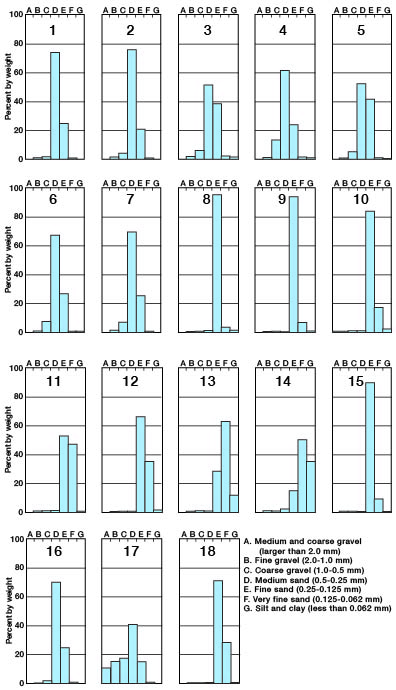
The histograms (Fig. 8) show the degree of sorting and the size of the material of each sample. Most of the samples consisted of well-sorted fine to medium sand. Samples 8, 9, and 10 were very well sorted and consisted almost entirely of fine sand. The largest amount of silt and clay was found in sample 14, which was collected from near the top of the formation. The material making up the conglomerate lenses of the Cheyenne sandstone is very poorly sorted, as shown by the histogram of sample 17. The size of the material in the conglomerate ranged from fine sand to coarse gravel.
Distribution and thickness--Southern Kansas is the only place in the state where the Cheyenne sandstone is exposed. Here it crops out as an irregular narrow band around the headwaters of Medicine Lodge River, Mule Creek, Bluff Creek, and other streams in Barber, Kiowa, and Comanche counties. Exposures of sandstone in Clark County are of undetermined age, but may belong to the Cheyenne sandstone. The best exposures are found in Kiowa County where the Cheyenne crops out in irregular bands on both sides of Medicine Lodge Valley in the southeastern part of the county and in a small area on the west side of Wiggins Creek in the SW sec. 36, T. 30 S., R. 20 W., in the southwestern part of the county (Pl. 1). Erosion has removed the Cheyenne in Medicine Lodge Valley and its larger tributary valleys from a point a few miles above Belvidere to the east county line. Results of the test drilling indicate that the Cheyenne is present beneath younger formations in all but the southeastern part of the county (Pl. 5 and logs 1, 6, 15, 16, 18, and 19) and is extensively distributed in the subsurface of central and western Kansas.
There is considerable variation in the thickness of the Cheyenne sandstone owing chiefly to the uneven erosion surface on which the sediments were deposited. The measured thicknesses of the sandstone in southeastern Kiowa County ranged from 32.5 feet in Champion draw (measured section 3) south of Belvidere to more than 94 feet in the SW sec. 26, T. 30 S., R. 16 W. (measured section 8). The top of the formation was not present at the latter section. The thickness of the Cheyenne in the subsurface as determined from test drilling ranged from 17 feet in test hole 18 (log 18) in the southwestern part of the county to 59 feet in test hole 6 (log 6) in the northwestern part of the county. The average thickness of the Cheyenne sandstone in Kiowa County as determined by measured sections and logs of test holes is about 45 feet. The thickness of the Cheyenne is 55 feet in Barber County (Knight, 1929), 60 feet or more in northwestern Morton County (McLaughlin, 1942 p. 75), about 55 to 60 feet in Stanton County (Latta, 1941, p. 71), 33 to 66 feet in Hamilton and Kearny Counties (McLaughlin, 1943, p. 118), and more than 200 feet in Ellis County (Frye and Brazil, 1943, p. 17). It is 5 feet thick in Texas County, Oklahoma (Schoff, 1939, p. 54), less than 35 to 70 feet thick in Cimarron County, Oklahoma (Schoff, 1943, p. 74), and 30 to 45 feet thick at Two Buttes, in southeastern Colorado (Sanders, 1934, p. 865).
Water supply--The Cheyenne sandstone is permeable enough in most places to supply water for stock and domestic purposes, but the great depth at which it lies in much of the county and the poor quality of the water it contains have prevented much development of its water supply. In most places in Kiowa County, adequate supplies of water of good quality can be obtained from younger formations above the Cheyenne sandstone. Water in the Cheyenne probably is under artesian pressure nearly everywhere in this area except in and near the areas of outcrop, but nowhere is the head great enough to cause wells to flow (pp. 30-31).
Four of the 101 wells (59, 66, 80, and 100) visited in Kiowa County tap the Cheyenne sandstone, and all are in the south-central and southeastern parts of the county (Pl. 2). Only one (well 66) of the 4 wells was in use at the time of my visit in 1941. The depths of these wells range from 60.8 feet (well 100) to about 275 feet (well 66), and in 1941 the depth to water level in them ranged from about 54 to 142 feet below land surface.
Springs have been reported in the Cheyenne sandstone in this area by Cragin (1895, p. 361) and Gould (1900, p. 16). Springs that formerly existed in the Cheyenne have since dried up (p. 46).
Analyses of the waters from two wells (59 and 66) that tap the Cheyenne sandstone in Kiowa County are shown graphically in Figure 7. The waters from both wells are highly mineralized, having respectively 9,235 and 3,138 parts per million of total dissolved solids, 3,068 and 1,075 parts of sodium and potassium, 1,141 and 277 parts of sulfate, 4,588 and 1,560 parts of chloride, and 1,090 and 330 parts of hardness. Both waters also contained undesirable amounts of iron and fluoride (Table 4). The high mineral content of these waters causes them to have a disagreeable taste. The owner of well 59 reports that the water from his well is unfit for domestic or stock use.
Kiowa shale
The Kiowa shale, as the term is used in this paper, includes the thick series of marine shale, sandstone lenses, and fossiliferous limestones that occur above the Cheyenne sandstone and below the Dakota formation. No members of the formation are recognized, but it includes units formerly called Champion shell bed, Spring Creek clay, Greenleaf sandstone and the lower part of Gould's (1900) Medicine Beds. It is equivalent to Twenhofel's (1924) Belvidere formation. The Kiowa shale was named by Cragin (1894a, p. 49) from exposures in Kiowa County, Kansas.
Character--The contact between the Kiowa shale and the underlying Cheyenne sandstone is conformable in most placs, but locally it may be unconformable. The Kiowa shale is overlain conformably by the Dakota formation or unconformably by the Meade and Ogallala formations. Although many good exposures of the Kiowa are found in the county, the top and bottom of the formation are nowhere found in the same exposure. The lower part of the formation and its contact with the Cheyenne sandstone are well exposed in the vicinity of Belvidere (measured sections 3, 4, 5, and 10). The upper part and contact with the Dakota formation are exposed in Medicine Lodge Valley and its tributary valleys several miles upstream from Belvidere (measured sections 12 and 15).
The Kiowa shale consists dominantly of thinly laminated dark-gray to black shale in the lower part, grading upward into gray, tan, mottled gray, red, and brown or tan, red and brown clay and clay shale. The shale in the lower part generally is black and has been called a paper-shale because it is so thinly laminated. A conspicuous feature of the formation, especially of the lower part, is the presence of thin beds of shell limestone--a name that has been given to these beds because they consist almost wholly of fossil shells. These limestone beds are from 3 to 18 inches thick, generally are light gray, and locally contain gypsum or pyrite. The matrix consists of shell fragments and sand or of sand and clay. In some places oxidation of the pyrite has caused the rock to disintegrate and the fossils have been largely decomposed. Where this has happened the shell bed is stained with iron giving it a red-brown or rusty color. A shell bed at the base of the Kiowa shale was named the Champion shell bed by Cragin (1895, p. 368), who gave it a rank equivalent in stratigraphic value to the Cheyenne sandstone and Kiowa shale. The term "Champion shell bed," however, has only local value in designating this basal shell bed. It is persistent in parts of the Belvidere area, where it forms a prominent bench above the Cheyenne sandstone (Pl. 8B and 8C) but was not recognized in any of the test holes drilled in other parts of the county. There appears to be no essential difference between the Champion shell bed and other shell beds in the Kiowa, although Cragin believed the fauna of the Champion shell bed was different from that of the rest of the Kiowa shale.
A large lens of cross-bedded yellow-tan to buff fine-grained sandstone occurs in some places at the top of the Kiowa shale on the Greenleaf and Parkin ranches about 10 miles west of Belvidere. The thickness of the sandstone lens in Spring draw in the SE sec. 4, T. 30 S., R. 18 W. is 29 feet (measured section 15). Smaller lenses of yellow-tan angular clay pebbles occur in the sandstone, and a thin bed of iron-cemented sandstone that contains small clay pellets and shark teeth caps the sandstone in the SE sec. 2, T. 30 S., R. 18 W. Gould (1898, p. 174) named this sandstone the Greenleaf sandstone from exposures on the Greenleaf ranch. Inasmuch as the sandstone is merely a lens of limited extent, differentiation of it as a stratigraphic unit is not justified. The same applies to the Spring Creek clay--the term Gould (1898, p. 174) used to describe the clay underlying the Greenleaf sandstone. These units have not been recognized with certainty outside of their type areas. Near the top of a high hill on the south side of Medicine Lodge River in the E2 sec. 16, T. 30 S., R. 17 W., about 5 feet of cross-bedded tan to buff fine-grained sandstone is exposed (measured section 12) at the top of the Kiowa shale; it may be the thinned extension of the sandstone lens exposed on the Greenleaf and Parkin ranches or it may be a part of another lens. Thinner beds or lenses of sandstone occur throughout the Kiowa shale. They are from less than an inch to about 18 inches thick and consist of white or light- to dark-gray fine-grained sandstone. The Champion shell bed in many places is capped by a thin bed of sandstone.
Gypsum, generally in the form of selenite, is common throughout the formation and occurs both in the beds of shell limestone and at many different places in the shale. A layer of fibrous aragonite having a cone-in-cone structure was found capping beds of shell limestone in two (3 and 10) of the sections measured and was found interbedded between gray to tan shale and black shale in one section (12). Small red-brown iron concretions are found in various parts of the Kiowa shale, but are more abundant in the clay and clay shale near the top of the formation (measured section 15). Ironstone, occurring in beds from less than an inch to about 20 inches in thickness, is also common in the upper part of the formation.
Distribution and thickness--The Kiowa shale is extensively exposed on both sides of Medicine Lodge Valley in the southeastern part of Kiowa County (Pl. 1) and is found beneath younger sediments everywhere in the county except the southwestern part (Pl. 5). Erosion has removed much of the Kiowa shale in the eastern and southern parts of the county and has completely removed it in the southwestern part (Pl. 5). A complete section of the Kiowa is not exposed anywhere in the county, but the thickness of the Kiowa in test hole 6 (log 6) in the NW. sec. 26, T. 27 S., R. 20 W., was 262 feet and in test hole 15 (log 15) in the SE sec. 4, T. 30 S., R. 18 W., it was 293 feet.
The Kiowa shale is exposed over a wide area in central Kansas where the maximum thickness is reported to be 100 to 125 feet (Plummer and Romary, 1942, p. 323).,
Water supply--The Kiowa shale consists predominantly of relatively impermeable shale and clay and in general is a poor water-bearing formation. The large lens of sandstone at the top of the formation supplies moderate amounts of water to well 91 (Pl. 2) and to springs 16, 17, and 18 (Fig. 6) in the northeastern part of T. 30 S., R. 18 W. Well 91 is an unused stock well 154 feet deep in which the water level stands about 107 feet below the land surface.
Springs 16 and 18 issue from the sandstone above its contact with the underlying clay. The estimated discharge of spring 16 is 1 to 2 gallons a minute. Spring 18, which discharges into a large concrete box built against the bluff of sandstone, is reported to yield adequate water for 100 cattle. Spring 17 issues from the sides and bottom of a small steep-walled draw that has been cut in the sandstone. The estimated yield of this spring is about 5 gallons a minute.
Analyses of samples of water from springs 16 and 18 are shown graphically in Figure 7 and are given in Table 5. The waters from springs 16 and 18 are moderately hard calcium bicarbonate waters and are very similar in quality to the waters in the Meade and Ogallala formations.
Gulfian Series
Dakota Formation
Character--The Dakota formation as herein described includes those Cretaceous beds of continental origin in Kiowa County that lie above the Kiowa shale. It includes all the beds formerly classed as Kirby clay and Reeder sandstone and in addition higher beds found only in the subsurface in this area. The line of division between the Dakota formation and the Kiowa shale is arbitrarily placed at the top of the highest bed of predominantly marine origin. The Dakota formation in Kiowa County is overlain unconformably by silt, sand, and gravel of Tertiary and Quaternary age.
The best exposures are found at the head of Spring draw (Pl. 10A, measured section 15), where about 10 feet of hard dark-brown iron-cemented sandstone containing large nodular concretions (Pl. 10B) is underlain by about 12 feet of tan and brown fine to medium loose sand. Below the sand is red and light-gray silty shale that grades downward into tan clay shale containing small red iron concretions, mottled red and gray clay shale, and light-gray silty shale containing thin beds of yellow-buff fine-grained sandstone. The clay and clay shale is about 20 feet thick and is underlain by sandstone of the Kiowa shale.
In an exposure in the E2 sec. 16, T. 30 S., R. 17 W., at the top of a high hill on the south side of Medicine Lodge Valley, the Dakota consists of 2 feet of hard dark-brown sandstone underlain by 5 feet of tan to gray clay (measured section 12). No plant remains have been found at this locality.
In the subsurface the Dakota formation consists of light-gray to blue-gray, yellow, yellow-tan, and mottled red and gray clay; light-gray to blue-gray shale; and tan to white and dark-brown fine- to coarse-grained sandstone (logs 6, 8, 9, 10, 13, and 15). The clay is commonly silty or sandy, generally contains small pellets or concretions of hematite, and in some places contains thin beds of hard red-brown to dark-brown iron-cemented sandstone. Lenses and thin beds of gray fine-grained sandstone occur locally in the beds of clay and shale. Test hole 6 (log 6) in the northwestern part of the county encountered above the Kiowa shale 78 feet of light-tan to white sandstone which is composed predominantly of fine to coarse angular to subrounded grains of clear quartz and contains numerous small pellets or concretions of hematite. Thin dark-gray shale partings occur near the base of the sandstone. The lower 5 feet in test hole 13 (log 13) consisted of hard dark-brown iron-cemented sandstone containing thin beds of light-gray shale. Test hole 15 (log 15), drilled at the head of Spring draw, encountered the same sequence of Dakota beds as that measured in the draw (measured section 15).
Distribution and thickness--The Dakota formation is exposed in only two small areas in Kiowa County; in the SE sec. 4 and in the SW sec. 3, T. 30 S., R. 18 W. (Pl. 1). As a result of post-Dakota erosion the formation is not present everywhere in this area. Results of the test drilling indicate that the Dakota is present in central and northwestern Kiowa County but is absent in all other parts of the area (Pl. 5).
Mortar beds of the Ogallala formation (Tertiary) are exposed along the sides of Spring draw in the SE sec. 4, T. 30 S., R. 18 W., topographically below the Dakota formation, indicating that during a part or all of Ogallala time the Cretaceous rocks formed a hill around which Ogallala sediments were deposited (Pl. 10A). The form of the hill is shown by the contour map of the pre-Ogallala surface in Figure 10.
The Dakota formation attains a maximum known thickness of 90 feet in the northwestern part of Kiowa county, where it was penetrated by test hole 6 (log 6). From here it thins to a featheredge toward the south, southeast, and east, and it probably thickens toward the northwest, for Waite (1942, p. 144) reported a thickness of 235 feet for the Dakota in the northeastern part of Ford County.
Water supply--No wells in Kiowa County are known to tap the Dakota formation for water, as adequate supplies of water of good quality generally are obtainable from deposits above the Dakota. Wells 32-34 at Greensburg and wells 42 and 43 at the booster station of the Northern Natural Gas Company were drilled into the Dakota formation merely to deepen the wells so that air-lift pumps could be installed. It is believed that these wells obtain most of their water from the Meade and Ogallala formations but possibly obtain some water from the Dakota formation.
Many of the domestic and stock wells in northeastern Ford County obtain water from the Dakota formation (Waite, 1942, p. 145), and some wells in Edwards County, which adjoins Kiowa County on the north, also obtain water from this formation.
Tertiary System
Pliocene Series
Ogallala formation
The clay, silt, sand, and gravel below the dune sand and alluvium and above the Cretaceous bedrock in Kiowa County have in the past been referred to the Ogallala formation of Pliocene age. Courtier (1934, pp. 33-38) recognized the presence of Quaternary deposits older than the dune sand and alluvium in this area and placed them in the Sanborn formation. Sufficient evidence is now available to show that a large part of the material formerly assigned to the Ogallala formation is Pleistocene in age and belongs to the Meade formation and Kingsdown silt.
The materials of the Ogallala and Meade formations are lithologically so similar that in some areas it was not possible to differentiate between them (Pl. 1). Certain exposures in the county are known to belong to the Meade formation and other exposures are known to belong to the Ogallala formation, but many other exposures have not been assigned definitely to one formation or the other.
Character--The Ogallala formation consists chiefly of calcareous silt, sand, and gravel, the proportions of which differ greatly from place to place. The materials are generally poorly sorted, vertical and lateral gradations from one lithologic type to another may take place within short distances, and in general the lenses of silt, sand, and gravel overlap one another irregularly. Some of the beds have been cemented with calcium carbonate, and in places the silt and fine to coarse sand is tightly cemented and forms a hard gray bed resembling old mortar (Pl. 7A).
The finer materials of the Ogallala formation consist of silt and some fine sand containing only very small amounts of clay. The silt and fine sand generally are tan, yellow-tan, brown, or gray, but many of the beds of silt are impregnated with lime and as a result are white to light gray.
Few beds that do not contain some sand are found, and many beds consist predominantly of sand. In general the beds of sand are poorly sorted, the texture ranging from fine- to coarse-grained. The sand beds are light gray, gray, tan, and brown and are composed chiefly of well-rounded to subangular grains of quartz. Silt generally is found intermixed with the sand, and in some beds it is difficult to determine whether silt or sand is most predominant. Minor amounts of gravel also are commonly found in the beds of sand.
Fine to coarse gravel constitutes the coarser materials of the Ogallala formation. The gravel is rarely clean, but generally contains much sand or silt. Gravel found at or near the base of the formation commonly contains abundant pebbles of weathered Cretaceous sandstone, ironstone, chert, and limestone, but the gravel higher up in the formation is composed almost entirely of material derived from igneous and metamorphic rocks, such as granite, quartz, and feldspar.
Caliche or lime carbonate is a common constituent of the Ogallala formation and occurs as cementing material, pipy concretions, nodules, or beds. The caliche is white to gray and generally is fairly soft. The bedded caliche is very irregular in thickness in this area, ranging from a few inches to a few feet. Test hole 6 (see log 6) penetrated a 7-foot bed of silty and sandy caliche--the greatest thickness encountered in this area. No beds of caliche belonging to the Ogallala formation were recognized at the surface in Kiowa County.
The general lithology of the Ogallala formation is indicated by the logs of several test holes given on pages 126-140--especially logs 6, 8, 9, 10, and 13.
Distribution and thickness--Because of the difficulty of distinguishing the Ogallala formation from the Meade formation, it is possible to give only the approximate areal distribution and thickness of the Ogallala. The only known exposures of the Ogallala formation in this area are found above the Cretaceous rocks along tributaries of Medicine Lodge River in the southeast part of T. 29 S., R. 18 W., in the northeast part of T. 30 S., R. 18 W., and along Middle Kiowa Creek in the central part of T. 30 S., R. 20 W., but there may be other exposures of the Ogallala formation in southern Kiowa County. Most of the upland surface in Kiowa County is underlain by deposits of Pleistocene age, but in test-holes the Ogallala formation has been found beneath these younger sediments over much of the central, western, and northwestern parts of the county. It is believed to be absent in the buried lowland areas in the eastern and southwestern parts of the county (Fig. 10). The Ogallala formation at one time probably covered all of Kiowa County and subsequently was removed entirely in parts of the county and partly in other parts by post-Ogallala erosion.
The thickness of the Ogallala ranges from a featheredge to about 65 feet. The formation attains its greatest thickness in the western and northwestern parts of the county where test holes 6, 9, and 10 encountered, respectively, 61, 65, and 64 feet of sediments that have been assigned to the Ogallala.
Water supply--Because the water-bearing properties of the Ogallala and Meade formations are similar and because it is difficult and in many places impossible to differentiate between the two in the subsurface, the description of their water-bearing properties is combined in the following paragraphs.
The sand and gravel of the Ogallala and Meade formations are the most important sources of ground water in Kiowa County. Most of the domestic and stock wells and all of the irrigation, industrial, and public-supply wells, with the exception of the Atchison, Topeka, and Santa Fe Railway wells (72 and 73) near Belvidere, derive water from these deposits. These formations also supply water to numerous springs in the southeastern and southwestern parts of the county (Table 9 and Fig. 6).
The finer materials of the Ogallala and Meade formations are generally porous and hold much water but are not permeable enough to yield water freely. The beds of sand and gravel, particularly the latter, are very good water bearers and generally yield abundant supplies of water. The yields of wells tapping these deposits range from a few gallons a minute for small domestic and stock wells to several hundred gallons a minute for the larger irrigation, industrial, and public-supply wells. The measured yield of irrigation well 15 was 712 gallons a minute with a drawdown of 17.8 feet. Irrigation well 11 is reported to yield 1,800 gallons a minute, but this figure may be too high.
The Ogallala and Meade formations form a large underground reservoir that is only partly filled with water. A greater thickness of the reservoir was saturated at one time, but streams have cut below the zone of saturation and are draining part of the water from the reservoir. Discharge measurements of the streams in Kiowa County indicate that in this area alone more than 19 million gallons of water a day is being drained out of this underground reservoir through springs and seepage areas (pp. 46-47). The thickness of the saturated material differs greatly, as shown by the diagrammatic section on Plate 5. More than 100 feet of saturated material is present in the northern and eastern parts of Kiowa County, and the greatest thickness of saturated material, about 260 feet, is in the northeastern part of the county. Logs of test holes indicate that a large part of the saturated zone in the Meade and Ogallala formations is composed of sand and gravel; therefore the amount of water available is large, particularly in the eastern part of the county where test holes 1 and 7 (logs 1 and 7) each encountered about 175 feet of saturated sand and gravel.
Analyses of 22 samples of water from the Ogallala and Meade formations were made; 19 of them were collected from wells (Table 4) and 3 from springs (Table 5). Analyses of typical waters from the two formations are shown graphically in Figure 7. All of the waters analyzed were moderately hard to hard calcium bicarbonate waters. Of the 22 samples of water analyzed from the Ogallala and Meade formations, 5 had less than 200 parts per million of dissolved solids, 14 had between 201 and 300 parts, and 3 had between 350 and 406 parts. The hardness of the samples ranged from 86 to 340 parts per million.
The iron content of the water in the Ogallala and Meade formations in general seems to be relatively low. Of the 22 samples, 18 had less than 1 part per million of iron, 3 had from 1.2 to 2.7 parts, and 1 had 4.8 parts. The fluoride content of the samples analyzed was negligible; all of the samples contained 0.6 part per million of fluoride or less.
Quaternary System
Pleistocene Series
Meade formation
Character--The Meade formation consists of interbedded lenses of clay, silt, sand, and gravel that is in part calcareous. The proportion of the different sediments varies from place to place, and gradations from one lithologic type to another generally take place within short distances, both laterally and vertically.
The finer materials of the Meade formation consist of clay and silt. The greatest thickness of clay exposed in this area was found on the side of a hill in the NE sec. 12, T. 30 S., R. 16 W., where about 11 feet of mottled green and brown sandy blocky clay crops out (bed 12, measured section 5). Thin beds and nodules of caliche and some volcanic ash were found in the clay at this locality. Clay was also found exposed on the side of a hill in the NE sec. 5, T. 30 S., R. 16 W. (bed 2, measured section 2), in a road cut in the SE sec. 32, T. 30 S., R. 17 W. (bed 1, measured section 14), and in a draw in the SE sec. 13, T. 30 S., R. 18 W. (bed 1, measured section 16). The clay generally is silty or sandy and is variegated-gray, brown, and green are the dominant colors. The individual beds range in thickness from about 3 feet to 11 feet. Clay was encountered in only one test hole (12), which penetrated 27 feet of tan, gray, and blue-gray silty and sandy clay near the base of the Meade formation. Small invertebrate fossils were found in samples of clay from this test hole (see log 12). Much of the clay in the Meade formation seems to be reworked clay and shale from the Kiowa shale and Dakota formation.
Lenses of silt and sandy silt ranging in thickness from a few inches to about 50 feet were penetrated in test drilling. Silt may be encountered in any part of the Meade formation, but seems to be more abundant in the upper part. The silt is tan, yellow tan, brown, or gray. Many of the lenses are very calcareous and are white to light gray (Pl. 7B).
The sand in the Meade formation generally is poorly sorted and ranges in texture from very fine to coarse grained. Sand rarely occurs in a bed by itself, but generally contains some silt or gravel or both. The dominant colors of the sand are tan, brown, and red brown or, where lime carbonate is present, light gray to white. A thin bed of black sand occurs in the bluff of a creek in the NW sec. 19, T. 30 S., R. 20 W. (measured section 18); the black color is due to staining of the individual grains.
The coarser materials of the Meade formation consist of fine to very coarse gravel in which cobbles up to 3 or 4 inches in diameter are not uncommon. Lenses of clean gravel are uncommon, but lenses of intermixed sand and gravel make up a large part of the formation. The Meade formation at test holes 1, 2, 4, 6, 7, 9, 11, and 18 is composed of about 60 to 90 percent intermixed sand and gravel. Individual lenses of sand and gravel range in thickness from a few feet to more than 100 feet, and thin lenses of silt and sand occur within the thick lenses of sand and gravel. The gravel is composed chiefly of granite, feldspar, and quartz pebbles but includes a few pebbles of sandstone, ironstone, and limestone and some water-worn pebbles of caliche and "mortar bed" that were derived from the Ogallala formation. Cross-bedding in the sand and gravel is extremely common (Pl. 11A). In some places the beds of sand and gravel are loosely to tightly cemented by calcium carbonate. Coarse gravel of the Meade formation is found exposed along the southern boundary of the county, in the southwest corner, and over a wide area between Thompson Creek and the east county line.
Plate 11--A, Cross-bedded sand and gravel of the Meade formation in gravel pit in NE sec. 9, T. 29 S., R. 17 W.; B, outcrop of loess in road cut in the SE sec. 23, T. 29 S., R. 18 W.
Caliche occurs in the Meade formation as nodules, stringers, pipy concretions, or as irregular beds in the clay, silt, sand, and gravel. The color of the caliche is gray to white.
In some places the Meade formation contains beds of volcanic ash, and a lens of white massive volcanic ash forms a ledge at the top of a hill in the NE sec. 5, T. 30 S., R. 16 W. (Pl. 8B and measured section 2). The ash weathers to a gray tan. Volcanic ash also was found in the NE sec. 12, T. 30 S., R. 16 W., where it occurs as thin beds and nodules in clay (bed 12, measured section 5), and may occur elsewhere in Kiowa County. At a locality a few miles south of Kiowa County in sec. 12, T. 31 S., R. 18 W., Comanche County, ash of the Meade formation has been mined commercially. The maximum thickness of the ash here as indicated by core drilling is 22 feet (Hibbard, 1944, p. 743). Several large deposits of ash in Meade County are also mined commercially.
Distribution and thickness--The Meade formation is present nearly everywhere in Kiowa County except in the southeastern part, where Medicine Lodge River and its tributaries have removed it and exposed Pliocene and Cretaceous rocks. Most of the area indicated as being underlain by the Ogallala and Meade formations undifferentiated on the geologic map (Pl. 1) is believed to be underlain by deposits of the Meade formation, but in other parts of the county the Meade is covered by the Kingsdown silt or by dune sand. The Meade formation probably is thin in the area in south-central and west-central Kiowa County occupied by the buried Cretaceous highland (Fig. 10), and probably is missing entirely in the extreme western part of this area (log 10). All of the material from the base of the Kingsdown silt or the dune sand to the Cretaceous bedrock in the buried lowland areas in the eastern and southwestern parts of the county (Fig. 10 and Pl. 5) probably belongs to the Meade formation.
The thickness of the Meade formation ranges from a featheredge to nearly 300 feet. The thickest deposits in this area occur in the buried lowland area in the eastern part of the county, where test holes 1 and 7 encountered, respectively, 289 and 186 feet of sediments that have been assigned to the Meade. In the buried valley in the southwestern part of Kiowa County the Meade attains a maximum thickness of about 152 feet (test holes 16 and 18).
Water supply--The water supply of the Meade and Ogallala formations is discussed on pages 93 and 94.
Pleistocene and Recent Series
Kingsdown silt
Character--Overlying the Meade formation in parts of southwestern Kansas is a series of beds known as Kingsdown silt. In Kiowa County it consists dominantly of silt and sandy silt but also contains minor amounts of clay, fine to coarse sand, and fine gravel. The coarser material is generally found at or near the base of the formation. Stringers, nodules, and thin beds of caliche occur in all parts of the formation, although many beds contain no limy material. Loess or massive silt is common in the upper part of the Kingsdown (Pl. 11B). The Kingsdown silt is dominantly light tan to brown, although some light-gray beds were observed.
The thickest and best exposures of the Kingsdown silt are found at the head of East Kiowa Creek on the Weaver ranch in the southwestern part of Kiowa County. The formation is loosely consolidated and is easily eroded to form rather narrow steep-sided gulches having rounded divides and abrupt edges. Plate 3B shows the typical topographic expression of the Kingsdown silt.
Distribution and thickness--The Kingsdown silt is the surface formation over the entire upland area and the Mule Creek drainage area in the southern half of Kiowa County (Pl. 1). It probably also underlies the dune sand in places in the northern half of the county.
The thickness of the formation ranges from a featheredge to a known maximum of 91 feet (test hole 17), but is believed to be more than 100 feet in parts of southwestern Kiowa County (Pl. 5). Waite (1942, p. 165) reported a maximum thickness of 123 feet of Kingsdown silt in southern Ford County and stated that it is 90 to 118 feet thick in the southwestern corner of that county.
Water supply--The Kingsdown silt does not supply water to any wells or springs in Kiowa County. The materials composing the Kingsdown are relatively impermeable and would yield little or no water; moreover, the formation is believed to be above the water table everywhere in the county.
Terrace deposits
Two terraces occur along Medicine Lodge Valley in southern Kiowa County. They have been mapped with the alluvium on the geologic map (Pl. 1). The lower terrace is 3 to 5 feet above the level of the flood plain and the upper and more prominent terrace is 10 to 15 feet above, the flood plain (Pl. 6B). Remnants of the two terraces are found on both sides of the valley but are more prominently displayed on the south side. The materials comprising the terrace deposits were derived from local sources and consist mainly of sandy silt and minor amounts of sand and gravel. Gray and tan brown are the dominant colors, but red or red-tan beds are common below Belvidere where a part of the material was derived from red Permian sediments. The gravel ranges from fine to very coarse in texture and is composed of pebbles and cobbles of reworked Pleistocene, Pliocene, Cretaceous, and Permian rocks.
The terrace deposits along Medicine Lodge Valley in Kiowa County may be equivalent in part to the Gerlane formation of Barber County which Knight (1934, p. 91) named and described from exposures near the town of Gerlane in southeastern Barber County. The deposit, Knight says (p. 91):
. . . is of alluvial origin, the material having been derived from the Permian and the Tertiary formations in the area. The Gerlane occurs both as valley filling and as surface wash. The former type is best developed in the larger valleys, giving them smooth broad floors. Where partly removed by erosion, the Gerlane forms terraces along the sides of the valleys. The surface-wash phase of the formation covers much of the inter-valley areas of the lower slopes.
The slopes of some of the larger valleys in southeastern Kiowa County are underlain by a variable thickness of reworked and redeposited Permian sediments that probably also are equivalent to the Gerlane formation. Such deposits are generally thin and non-persistent in this area; therefore, they have not been shown on the geologic map.
No wells are known to obtain water from the terrace deposits along Medicine Lodge Valley, and it is unlikely that these deposits would yield water to wells for they probably are everywhere above the water table.
Terrace gravel of late Pleistocene age is known to occur at the surface and beneath dune sand along, Arkansas Valley west of Kiowa County (Waite, 1942, p. 168; Latta, 1944, pp. 177-180; McLaughlin, 1943, p. 141). Part of the gravel found beneath the dune sand in the northern part of Kiowa County probably is equivalent to the terrace gravel farther west, but as it is not exposed and because of its similarity to gravel of the Meade formation it was not possible to separate the terrace gravel from the Meade formation.
Dune sand
Dune sand of Quaternary age covers approximately the northern third of Kiowa County, and in the eastern part of the county a relatively narrow area of dune sand extends southward to within about 5 miles of Belvidere (Pl. 1). The dune sand is composed predominantly of fine- to, medium-grained quartz sand and contains minor amounts of clay, silt, and coarse sand. The sand has been accumulated by the wind to form low mounds and small hills, some of which are 60 feet or more high (Pl. 3A).
No wells obtain water from the dune sand in Kiowa County for it is everywhere above the water table, but, owing to the looseness and relatively high permeability of the sand, it serves as an important catchment area for ground-water recharge from local rainfall.
Alluvium
Recent alluvium occurs in most of the stream valleys in Kiowa County (Pl. 1). The alluvium in all of the valleys except Medicine Lodge is thin and occurs only as very narrow bands along the present channels; therefore it is not shown on the geologic map.
The alluvium consists of stream-laid deposits that range in texture from clay and silt to sand and very coarse gravel. The upper few feet of alluvium in Medicine Lodge Valley consists of silt and fine to coarse sand that were deposited over the flood plains in time of flood or under normal conditions in the channel of the stream. Coarse sand and gravel, which occurs beneath the finer surficial deposits, is poorly sorted and is composed of pebbles of igneous rocks, sandstone, shale, and mortar bed and fragments of shells from the Cretaceous rocks. The material was derived locally from Pleistocene, Pliocene, Cretaceous, and Permian formations. The thickness of the alluvium in Medicine Lodge Valley is not known with certainty but is believed to range from a few feet to about 40 feet.
The alluvium in the tributary valleys of Medicine Lodge River probably is similar to the alluvium in Medicine Lodge Valley, but in general it is much thinner. The alluvium in Rattlesnake Creek, Mule Creek, and Sand Creek Valleys and in valleys tributary to them was derived chiefly from Pleistocene and Pliocene formations and therefore consists dominantly of granitic material.
Records of five wells (75, 76, 77, 79, and 88) that obtain water from the alluvium of Medicine Lodge Valley were obtained. They are small drilled or driven wells and range in depth from 8 to 30 feet. The water level in them. ranges from about 5 to 20 feet below the surface.
The analyses of three samples of water collected from wells (75, 76, and 88) tapping the alluvium in Medicine Lodge Valley indicate that the water in the alluvium generally is hard. The samples from two of the wells (75 and 88) were hard calcium bicarbonate waters containing, respectively, 545 and 432 parts per million of total solids and 330 and 316 parts of hardness. The fluoride and iron content of these two samples was relatively low. The sample from well 76 was a very hard calcium sulfate water that contained 2,400 parts per million of total solids and had a hardness of 1,782 parts. The sample contained one part per million of iron and 1.2 parts per million of fluoride.
Records on one well (99) that obtains water from the alluvium in a tributary valley of Sand Creek and two wells (72 and 73) that tap the alluvium in Soldier Creek valley (Pl. 2) were also obtained. Well 99 is a driven domestic well 22 feet deep in which the water level stands about 10 feet below the surface. Wells 72 and 73 are 13 and 12 feet deep, respectively, and the water level in them stands about 4 feet below the surface. Well 72 was not in use in 1941. Well 73 is owned by the Atchison, Topeka and Santa Fe Railway and is used to supply water for filling locomotive boilers at Belvidere. It has a reported yield of 180 gallons a minute. The water is treated for use in boilers.
Prev Page--Chemical Character || Next Page--History
Kansas Geological Survey, Geology
Placed on web Feb. 4, 2008; originally published Feb. 1948.
Comments to webadmin@kgs.ku.edu
The URL for this page is http://www.kgs.ku.edu/General/Geology/Kiowa/06_form.html