![]()
Prev Page--Formations || Next Page--Well Records
Geologic History
Paleozoic Era
Paleozoic rocks older than the Permian are not exposed in Kiowa County; therefore, comparatively little is known of the events during the early Paleozoic. A few test wells drilled in search for oil have penetrated thick deposits of Pennsylvanian, Ordovician, and Cambrian marine limestones and shales below the Permian, indicating that the area was covered by seas during much of the Paleozoic era. No rocks of Silurian and Devonian age are known to have been encountered in the oil test wells drilled in Kiowa County. This fact indicates either that this was a land area during the Silurian and Devonian periods or that any sediments that may have been deposited were later removed by erosion, possibly during early Mississippian time. Marine conditions during early Permian time were followed by an interval of alternating marine and continental deposition, but near the end of Permian time continental deposition became predominant, forming the redbeds that are now exposed in southern Kiowa County. The presence of salt and gypsum (Medicine Lodge gypsum member of the Blaine formation) in beds of Late Permian age indicates that the climate was somewhat more arid than it is at the present. The deposition of these evaporites probably took place in shallow basins of inland seas. According to Norton (1939, p. 1809) the red silts of the Whitehorse sandstone represent desert sediments.
Mesozoic Era
Triassic and Jurassic Periods
A general uplift of the Paleozoic rocks of this region terminated Paleozoic deposition, and the streams that had been depositing began to erode the Permian surface. Erosion probably continued throughout all of Triassic and Jurassic time, for sediments of these periods are not known to occur in Kiowa County.
Cretaceous Period
The Permian surface at the time Cretaceous sedimentation began was one of little relief (Pl. 5). During the Comanchean epoch of the Cretaceous period the sea once more invaded this area, and clastic sediments composed chiefly of sand, but containing minor amounts of finer material, were deposited on or near the shore line of this advancing sea. These sediments make up the Cheyenne sandstone--a dominantly continental deposit. As the Comanchean sea advanced northward all of the Kiowa County area was inundated, and the marine sediments composing the Kiowa shale were deposited.
A general withdrawal of the sea marked the end of Early Cretaceous time. Interbedded marine and continental beds indicate that the retreat of the sea was not continuous but was marked by minor readvances. After the retreat of the Early Cretaceous sea, continental deposits of clay and sand (Dakota formation) accumulated in stream channels, on floodplains, beaches, and in lagoons. More detailed descriptions of the origin of the Cheyenne sandstone, Kiowa shale, and Dakota formation are given in the chapter on Geologic formations and their water-bearing properties.
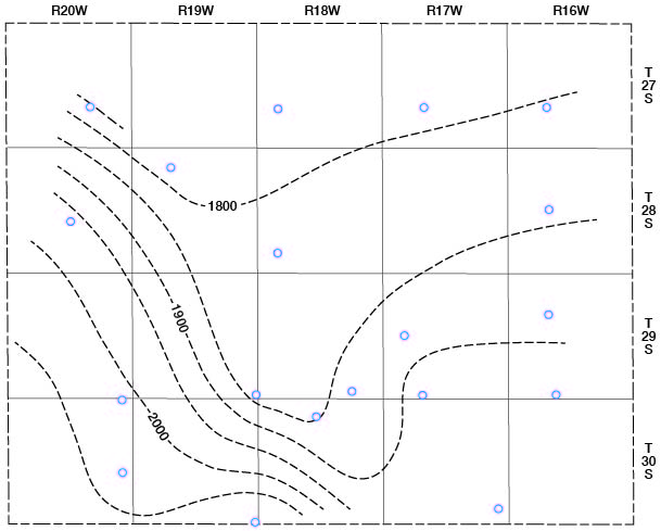
After the deposition of the Dakota formation the sea again invaded western and central Kansas, and great thicknesses of clay and limestone (Graneros shale, Greenhorn limestone, Carlile shale, Niobrara formation, and Pierre shale) accumulated in this Late Cretaceous sea. Although no Cretaceous rocks younger than the Dakota formation are now present in Kiowa County, the Graneros shale and Greenhorn limestone occur in nearby areas to the west and northwest and probably also were deposited in part or all of Kiowa County, but have since been eroded away. At the close of the Cretaceous period great orogenic movements produced the Rocky Mountains and affected at least a part of the Great Plains. During this time, or possibly during early Tertiary time, the Cretaceous and older beds in Kiowa County underwent moderate folding, as shown by contour lines drawn on the top of the Cheyenne sandstone in Figure 9. A broad synclinal trough trends northwest southeast across the central part of the bounty. The southwest flank of the trough rises steeply at the rate of 25 to 40 feet to the mile; the northeast flank rises very gently and gradually flattens out. A part of the structure shown in Figure 9 may be primary, as the Cheyenne sandstone was laid down on an erosional surface.Fig. 9--Structure of Kiowa County shown by contours drawn on top of the Cheyenne sandstone. The location of test holes, oil test well, and a core hole are indicated by circles.
Cenozoic Era
Tertiary Period
During the early part of the Tertiary period extended erosion truncated the Cretaceous sediments. In parts of southern Kiowa County all the Cretaceous strata down to and including some Cheyenne sandstone were removed (Pl. 5); in the central, south-central, and northwestern parts of the county the Dakota formation was deeply eroded; and in other parts of the county the Dakota formation entirely wasted away and the underlying Kiowa shale was deeply eroded. Late in Tertiary time, during the Pliocene epoch, there was a reversal of conditions from stream erosion to stream deposition, and rock debris from the mountains to the west was deposited over this entire area by aggrading and laterally shifting streams. These deposits, consisting of silt, sand, and gravel, make up the Ogallala formation. The surface on which these sediments were laid down was an erosional surface of hills and valleys, as shown in Figure 10.
Fig. 10--Configuration of the pre-Ogallala surface in Kiowa County and location of test holes (numbered circles).
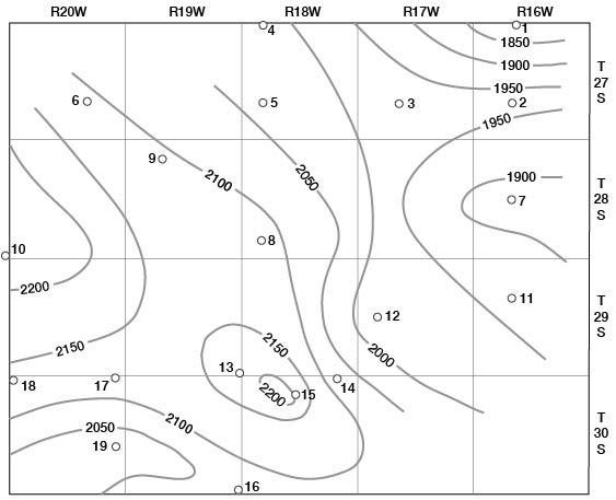
Figure 10 indicates that a broad highland existed in the south-central and western parts of the county in Ogallala time, and valley or lowland areas existed in the southwestern and eastern parts of the county. Ogallala sedimentation probably started in the lowland areas and, as it filled these, extended over the highlands.
Quaternary Period
Pleistocene epoch--Erosion in Late Tertiary or early Pleistocene time removed much of the Ogallala formation from Kiowa County, and in the eastern and southwestern parts and in a few other parts of the county the Ogallala was completely removed. After this erosion, there was another long age of deposition by aggrading and laterally shifting streams that produced thick deposits of clay, silt, sand, and gravel (Meade formation) resembling those of the Ogallala formation. These sediments probably were deposited by eastward-flowing streams carrying material from the Rocky Mountains and from the areas of Tertiary rock to the west.
Thick deposits of coarse gravel (Meade formation) in northern and eastern Kiowa County strongly suggest that a major stream, possibly the ancestral Arkansas river, flowed across this area during the Pleistocene epoch. Norton (1939, p. 1,798) suggests that the ancestral Arkansas River followed approximately the present course of Medicine Lodge River. At the present time the Arkansas follows a general easterly course from the state line to eastern Ford County, where it makes an abrupt turn to the northeast to form the "great bend." Lateral shifting, which is a common characteristic of an aggrading stream, and stream piracy probably were responsible for the change in the course of Arkansas River from that of Pleistocene time to the present location. Thick deposits of coarse gravel in the southwestern part of Kiowa County suggest that another major stream crossed that area during Meade time.
Another time of erosion followed deposition of the Meade formation, but it was shorter and less severe than those preceding. During late Pleistocene time stream-laid silt and fine sand comprising most of the Kingsdown silt were deposited over the Meade surface, and these are now widely distributed throughout Kiowa County.
Erosion has dominated the geologic history of this area since the water-laid part of the Kingsdown silt was deposited, but it has not been the only active geologic agent. Cutting of the present valleys probably started in late Pleistocene time. Pleistocene terraces along Medicine Lodge Valley indicate that the major part of that valley was cut and partly filled with sediments before the close of the Pleistocene epoch. Later erosion has removed much of the terrace deposits. The accumulation of wind-blown loess comprising the upper part of the Kingsdown silt probably started in late Pleistocene time and has continued into Recent time. Contemporaneous with or soon after loess deposition, sand dunes were developed in the northern half of Kiowa County. Where the dunes are not protected by a cover of vegetation, the sand is still being shifted and redeposited by strong winds.
Recent epoch--Much of the present topography of Kiowa County is the result of erosion and deposition that started during the latter part of the Pleistocene epoch and has continued to the present time. Erosion has progressed so far as to lay bare Cretaceous and Permian rocks in southeastern and parts of southwestern Kiowa County. Although downcutting and headward erosion by streams have been the dominant erosional processes, the wasting away of the unconsolidated deposits above the Cretaceous bedrock was accelerated by the sapping action of many strong springs that developed at the base of the unconsolidated deposits along the escarpment when the streams cut below the water table.
In addition to the deposition of loess and dune sand during Recent time, alluvium has also been deposited in all the major streams.
Prev Page--Formations || Next Page--Well Records
Kansas Geological Survey, Geology
Placed on web Feb. 4, 2008; originally published Feb. 1948.
Comments to webadmin@kgs.ku.edu
The URL for this page is http://www.kgs.ku.edu/General/Geology/Kiowa/07_hist.html