![]()
Prev Page--Contents || Next Page--Geography
Introduction
Purpose and scope of the investigation
The investigation on which this report is based is part of an extensive program of groundwater investigations in the state started in July 1937 by the Geological Survey, United States Department of the Interior, and the State Geological Survey of Kansas, with the cooperation of the Division of Sanitation of the Kansas State Board of Health and the Division of Water Resources of the Kansas State Board of Agriculture. This report presents the results of a study made during the summer of 1941 to determine the availability and quality of ground water and to study and map the various rock formations in Kiowa County.
The principal purpose of the investigation has been to provide basic information necessary to the satisfactory and economical development of domestic, stock, irrigation, industrial, and municipal ground-water supplies. Specific problems in regard to the quantity and quality of ground water that will require more detailed studies in particular areas may arise in the future.
The investigation was made under the general administration of R. C. Moore and K. K. Landes, state geologists, and O. E. Meinzer, geologist in charge of the Division of Ground Water of the Federal Geological Survey, and under the immediate supervision of S. W. Lohman, Federal geologist in charge of ground-water investigations in Kansas.
Location and size of the area
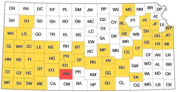
Kiowa County lies in south-central Kansas and embraces a total of 20 townships, or 720 square miles. Its location with respect to adjoining counties is shown by Figure 1.
Fig. 1--Index map of Kansas showing area described in this report and areas covered by other online geologic reports, as of Feb. 2008. For additional information, please visit the KGS Geologic Maps of Kansas Page.
Previous geologic and hydrologic work
The geology of Kiowa County, particularly the Cretaceous rocks in the southeastern part of the county, has attracted the attention of geologists for many years. During the last quarter of the last century more than 30 reports that pertained wholly or in part to the geology of Kiowa County were published. Most of these reports deal only with the Cretaceous rocks in the county. Mudge (1878), St. John (1883, 1887), Cragin (1885, 1886, 1889, 1889a, 1890, 1891, 1891a, 1894, 1894a, 1895), Hay (1887, 1890, 1893), Williston (1892), Knowlton (1895), Hill (1895), Prosser (1897), Vaughan (1897), Gould (1898, 1899, 1900), and Haworth (1897) are the geologists who made the more important of these field studies.
A report by Johnson (1901) on the "Utilization of the High Plains" deals with the physiography, underground waters, and the land economy of the High Plains, including Kiowa County. A second paper by Johnson (1902) contains conclusions and a summary of the first paper. Gould (1901) contributed an important paper entitled "The Dakota Cretaceous of Kansas and Nebraska," which includes specific data on the Cretaceous rocks of this area. A preliminary report on the geology and ground-water resources of the central Great Plains by Darton (1905) contains a brief reference to Kiowa County. A very brief description of the availability of ground water in Kiowa County, including analyses of some typical well waters collected at Greensburg and Wellsford, was given by Parker in 1911 (pp. 121-122). Two years later, Haworth (1913) gave a general description of the well waters in Kansas.
In 1920 Twenhofel published a short report on the "Comanchean and Dakota strata" of Kansas which includes many references to Kiowa County. A few years later he (Twenhofel, 1924) prepared a more detailed report on the same subject, and Twenhofel and Stryker (1925) outlined the subsurface distribution of the Comanchean rocks in western Kansas. A description of the flora of the Cheyenne sandstone of Kansas was published by Berry in 1922. All of the fossil plants described in Berry's paper were collected from the Cheyenne sandstone in Kiowa County. Bullard (1928) discussed the distribution, origin, and correlation of the Lower Cretaceous rocks of western Oklahoma and adjacent states. The following year Gould (1929) contributed a short paper on Comanchean reptiles from Kansas. An unpublished report on the geology of Barber County (Knight, 1929), which adjoins Kiowa County on the southeast, discusses chiefly the Permian formations of Barber County but also includes brief descriptions of the Comanchean and younger rocks. Of popular interest is the description of the excavation of a meteorite crater near Haviland, Kiowa County, by Nininger and Figgins (1933).
The physiography and geology of south-central Kansas, including most of Kiowa County, is described in an unpublished doctorate thesis by Courtier (1934). In 1937 Smith contributed a report on Pleistocene gravels in southwestern Kansas in which he lists fossils collected from a gravel pit south of Brenham, Kiowa County. A later report by Smith (1940) includes a few brief references to the geology of Kiowa County. In 1940 Moore prepared a generalized report on the ground-water resources of Kansas including Kiowa County.
A report published in 1942 on the availability of ground-water supplies for national defense industries in Kansas includes a description of the availability of ground-water supplies in eastern Kiowa County (Lohman and others, 1942, pp. 36-37). A general report describing the mineral resources of Kansas for wartime industries was also published in 1942 (Jewett and Schoewe). In the same year, Plummer and Romary described the stratigraphy of the pre-Greenhorn Cretaceous beds of Kansas. Although their report deals chiefly with central and north-central Kansas, it also includes important references to the Cretaceous geology of Kiowa County. In 1938 and 1939 Waite (1942) made a detailed study of the geology and groundwater resources of Ford County, which borders Kiowa County on the west. A similar study was made by Frank Byrne in Barber County in 1941, but as yet no report has been issued on this work. A report on water levels and artesian pressure in observation wells in the United States in 1940 includes a chapter on the observation-well program in Kiowa County (Meinzer and Wenzel, 1942, pp. 136-137). Similar reports for the years 1941 and 1942 were published in 1943 and 1944 (Meinzer and Wenzel, 1943, pp. 119-120; 1944, pp. 135-136) and additional reports of this series will be published annually. Reference is made to the geology of Kiowa County in a recent report by Hibbard (1944) on the Pleistocene deposits of southwestern Kansas.
Methods of investigation
The field work upon which this report is based occupied three months in the summer of 1941 and about two weeks in the summer of 1942. Approximately 100 wells and 27 springs were visited during this time. The total depth and the depth to water level were measured in about 72 of the wells. All measurements were made with a steel tape from a fixed measuring point at the top of each well. Information concerning the nature and thickness of the water-bearing material, yield of the wells and springs, and the use and general character of the water was obtained from many farmers and drillers in the county. Samples of water were collected from 30 wells and springs, and chemical analyses of these samples were made by H. A. Stoltenberg, chemist, in the Water and Sewage Laboratory of the Kansas State Board of Health at Lawrence.
During the summer and fall of 1941 eighteen test holes (Fig. 10) were drilled by Ellis D. Gordon, Perry McNally, and Laurence Buck, using a portable hydraulic-rotary drilling rig owned by the State and Federal Geological Surveys. Samples from the test holes were collected and studied in the field by McNally and were again studied in the office by me. Landowners and well drillers provided additional logs of wells in the county. The altitudes of the land surface at the sites of the test holes and the altitudes of the measuring points of the wells were determined by John B. LaDuex and Fay Mann, assisted by Milton Sears and Willis Ray. The water-table contours shown on Plate 1 are based upon these altitudes and the measured depths to water level in wells.
In 1941, Melvin Scanlan of the Division of Water Resources, Kansas State Board of Agriculture, and Woodrow Wilson of the Federal Geological Survey measured the flow of many of the spring-fed streams in the county. These measurements are given in Table 3.
The areal geology shown on Plate 1 was compiled from field studies supplemented by use of aerial photographs. Many geologic sections were measured (see pp. 117-126).
Field data were compiled on topographic maps of the U. S. Geological Survey and on a county highway map prepared by the State Highway Department. The county highway map was also used as a base map in preparing Plates 1 and 2. The drainage pattern was taken from aerial photographs obtained from the United States Department of Agriculture, Agricultural Adjustment Administration.
The locations of all wells and springs visited during the course of the investigation are shown on Plate 2, and the springs are also shown and numbered in Figure 6. The well and spring numbers on the maps correspond to the well and spring numbers used throughout the tables and text of this report.
Acknowledgments
I am indebted to numerous farmers, ranchers, well drillers, and city officials who willingly supplied information concerning the hydrology and geology of the county; without their aid it would not have been possible to write this report. I also wish to thank John C. Frye, executive director of the State Geological Survey, and Claude W. Hibbard, curator of vertebrate paleontology of the Dyche Musueum of Natural History, University of Kansas, who spent several days in the field with me studying the rocks of Kiowa County and adjacent areas. I am grateful to Hibbard and A. B. Leonard, assistant professor of zoology, University of Kansas, for their helpful identification of fossil material collected during this investigation.
The manuscript for this report has been critically reviewed by O. E. Meinzer and S. W. Lohman of the Federal Geological Survey; R. C. Moore, State Geologist, State Geological Survey of Kansas; George S. Knapp, chief engineer, Division of Water Resources, Kansas State Board of Agriculture; and Paul D. Haney, director, and Ogden S. Jones, geologist, Division of Sanitation, Kansas State Board of Health. The manuscript was edited by Johanna Kollmorgen and Betty Hagerman and the illustrations were drafted in final form by Robert White, Robyn Ashby, and Murl Rush.
Prev Page--Contents || Next Page--Geography
Kansas Geological Survey, Geology
Placed on web Feb. 4, 2008; originally published Feb. 1948.
Comments to webadmin@kgs.ku.edu
The URL for this page is http://www.kgs.ku.edu/General/Geology/Kiowa/02_intro.html