![]()
Prev Page--Geography || Next Page--Ground Water Principles and Water Table
Geology
[Note: The stratigraphic classification used in this report is that of the State Geological Survey Kansas.]
Summary of Stratigraphy
The rocks that crop out at the surface in Jewell County are sedimentary and range in age from Late Cretaceous (Gulfian) to Recent. A generalized description of the geologic formations and their water-bearing properties is given in Table 6; their areal distribution is shown on Plate 1.
Table 6--Generalized section of geologic formations in Jewell County. Classification of State Geological Survey of Kansas.
| System | Series | Formation | Member | Thickness, feet |
Physical character | Water supply |
|---|---|---|---|---|---|---|
| Quaternary | Pleistocene | Alluvium | 0-75 | Silt, sandy silt, and mixed gravel and silt along creeks. Sand and gravel along Republican River. | Yields small supplies of hard water in creek valleys, large supplies in Republican River valley. | |
| Limestone gravel |
0-15 | Subrounded to subangular limestone pebbles, sand and silt intermixed. | Yields meager to small supplies of hard water of shallow depth in the Jewell plain, small supplies locally beneath "high terraces." | |||
| Sanborn formation |
0-100 | Friable, massive, eolian silt and sandy silt containing snail shells and calcium carbonate nodules. Locally has sand and gravel (Crete member) at base. | Locally, where present and above water table, Crete member yields small supplies of water to wells. In northwestern part of county small yields may be obtained from silt. | |||
| Meade formation |
Sappa | 0-50 | Massive reddish silt; contains calcium carbonate nodules, stratified silt, fine sand, and volcanic ash. | Yields small supplies to wells 100 feet or more in depth in northwestern Jewell County. | ||
| Grand Island |
0-120 | Cross-bedded sand and gravel containing lenticular beds of limestone gravel and silty clay. | Yields moderate supplies of water to wells penetrating the channel fill of ancient Republican River in northeastern part of county, small supplies where present beneath Sappa member in northwestern Jewell County. | |||
| Cretaceous | Gulfian | Niobrara formation |
Smoky Hill chalk |
0-350± | Thin-bedded to fissile, blue-gray chalky shale and chalk; contains beds of massive chalk and thin bentonite and limonite seams. | Yields little or no water to wells. |
| Fort Hays limestone |
30-45 | Massive white chalky limestone. Forms prominent scarp. | Yields little or no water to wells in this area. | |||
| Carlile shale |
Blue Hill shale |
200 | Fissile, noncalcareous, gray to black marine shale; contains thin sandy zone at top and septarian and discoidal concretions. | Yields little or no water to wells in this area. | ||
| Fairport chalky shale |
100-110 | Fissile, calcareous marine shale; contains abundant Ostrea shells, thin chalky limestone, discoidal calcareous concretions, and thin bentonite seams. | Yields little or no water to wells in this area. | |||
| Greenhorn limestone |
65-82 | Calcareous blue-gray shale alternating with thin chalky fossiliferous limestones in upper part and thin crystalline petroliferous limestones in basal part. Contains bentonite beds. | Yields little or no water to wells in this area. | |||
| Graneros shale |
15-30 | Noncalcareous gray to dark-brown shale; contains persistent bentonite bed in upper part and locally pyrite, limestone, and siltstone. | Yields little or no water to wells in this area. | |||
| Dakota formation |
200-300 | Clay, shale, siltstone, and sandstone. Contains lignite locally about 30 feet below top. (Only upper 28 feet exposed in Jewell County). | Yields small supplies of water suitable for domestic and stock use to a few wells in southeastern Jewell County. Elsewhere in county contains highly mineralized water. |
The oldest rocks exposed in Jewell County are sandstone and shale of the Dakota formation which crop out in a small area on the south side of Buffalo Creek valley in the southeastern corner of the county. The Dakota formation is overlain conformably by a series of marine upper Cretaceous rocks classified, in ascending order: Graneros shale, Greenhorn limestone, Carlile shale, and Niobrara formation. Some of the higher hills in the southwestern and central parts of the county are capped by a few inches to a few feet of impure sandy caliche that may represent the Ogallala formation of Pliocene age, but which in this report is mapped with the Sanborn formation.
Unconsolidated continental deposits of fluviatile and eolian origin represent at least three stages of the Pleistocene series. These include the Meade formation of Kansan age, the most extensive deposit of which is over the northeastern part of the county between Republican River and White Rock Creek. Stream-laid deposits of the Meade formation also fill a narrow valley extending from near Mankato northward. Volcanic ash and associated silt beds in the northwestern and southern parts of the county also are a part of the Meade formation. Sand and gravel deposits of Illinoian age occur locally along White Rock Creek and Republican River beneath a high terrace. These deposits are overlain conformably by reddish sandy silt (the Loveland silt member), which may be in part stream laid but is eolian in the upland areas. Unconformably overlying the Loveland silt member and older rocks is the gray eolian silt of the Peoria silt member, which occurs in all parts of the county. Terrace deposits of late Wisconsinan age border each of the major streams and locally the smaller streams. The youngest rocks in the county are the deposits of Recent alluvium which are being formed along the streams at the present time.
Geomorphology
The topographic features of Jewell County are principally the product of Pleistocene erosion and deposition but are controlled, in part, by the character of the bedrock.
By the close of the Pliocene Epoch, Tertiary aggradation had created a broad alluvial plain across north-central Kansas that had buried the now prominent escarpments of the Niobrara formation and Greenhorn limestone. Locally, resistant hills of these rocks may have protruded as inliers above the general level of the alluvial plain, but the topography was one of low relief. The absence of deposits of the Ogallala formation overlying the Cretaceous rocks in Jewell County suggests that this part of Kansas was near the eastern edge of alluviation and may have been principally a degradational plain developed on Cretaceous rocks.
At the close of Tertiary time the plains area changed from a region of deposition to one of erosion. The Tertiary deposits and underlying Cretaceous rocks began to be eroded and the present drainage system began to form.
In early Pleistocene time the ancestral Republican River entered Kansas 5 or 6 miles west of the northeast corner of Jewell County, flowed southeastward, and passed into Republic County almost 5 miles south of the northeastern corner of Jewell County. The river then flowed northeastward across the northwest part of Republic County (Fishel, 1948, pp. 29-31). This ancient stream valley was cut during the Nebraskan and early Kansan Stages of the Pleistocene. During late Kansan time, the valley was filled with a thick accumulation of gravel, sand, and silt that now obliterates the valley features. A major stream, tributary to the Republican River of Kansan age, flowed eastward across the northern part of Jewell County, a few miles north of the present valley of White Rock Creek. This stream probably bad tributaries from both north and south, and the deposits of the Meade formation a few miles northwest of Mankato were formed in the valley of one of those tributary streams. Stream deposits from a north-flowing stream in the SW SW sec. 16 and NE NE sec. 20, T. 3 S., R. 8 W., almost 1 1/2 miles south of the present divide between White Rock and Buffalo Creeks, indicate that the drainage divide has shifted northward more than 1 1/2 miles (Fig. 8). Volcanic ash of Kansan age in the SE sec. 11, T. 4 S., R. 8 W. and in the SE sec. 20, T. 5 S., R. 9 W. indicates that those localities were in areas of south-flowing drainage and probably the drainage pattern was similar to the present one. Probably the south and southeast flowing Marsh, Buffalo, and Limestone creeks were well established by Kansan time.
Figure 8--Profile through Meade formation northwest and south of Mankato showing shift of drainage divide and possible retreat of Fort Hays limestone member escarpment since deposition of the Meade formation.
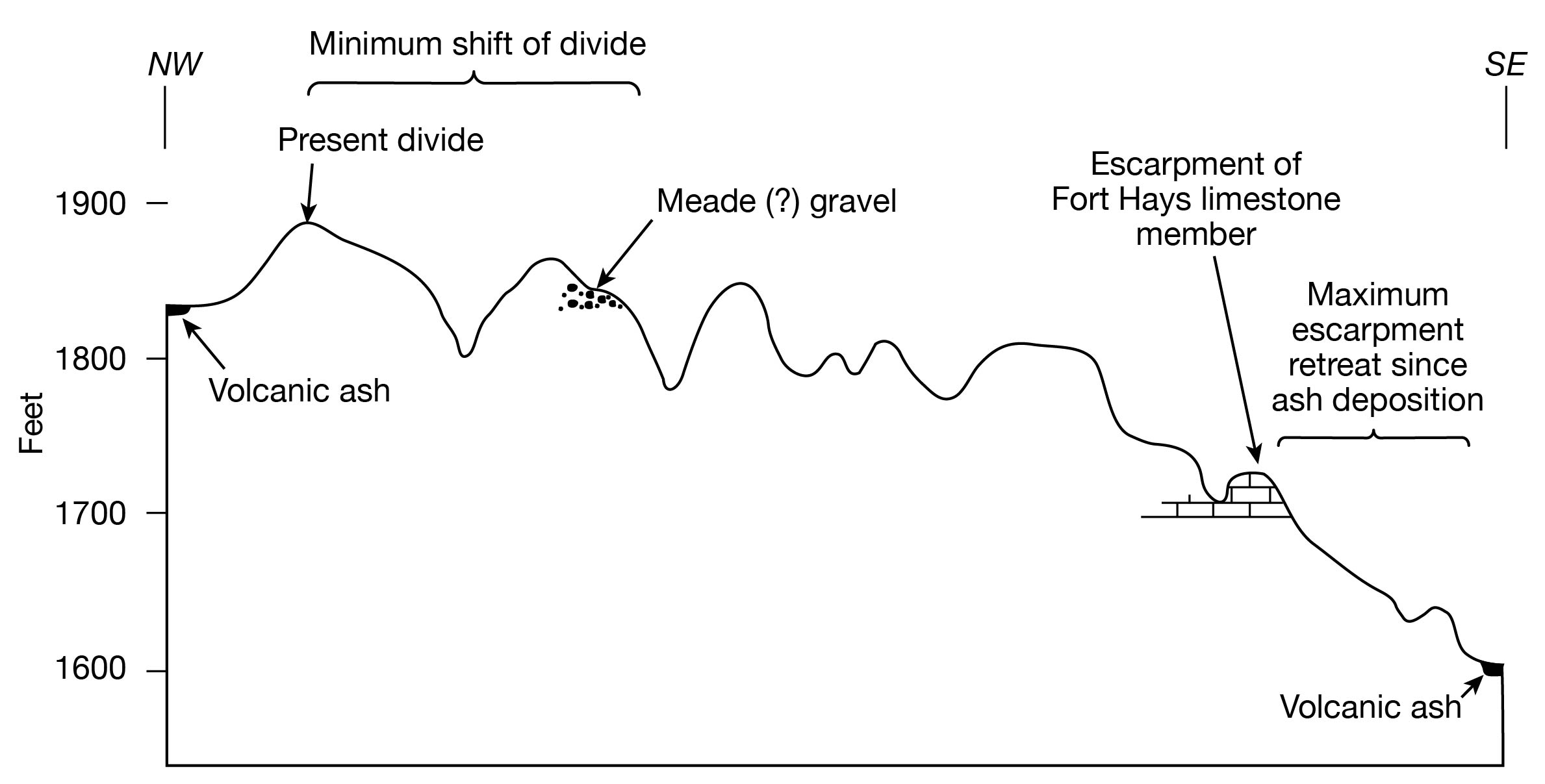
The erosion in early Pleistocene time probably dissected a large part of the Cretaceous bedrock in the upland areas and formed the now prominent escarpment of the Fort Hays limestone member of the Niobrara formation. The deposit of Pearlette ash of Kansan age in the SE sec. 11, T. 4 S., R. 8 W. about a mile from the face of the escarpment and 100 feet below it indicates that the escarpment must have been pronounced at the time the ash was deposited and has not retreated more than a short distance since its deposition.
Possibly most of the limestone gravel deposits, which are so extensive in southern Jewell County, were deposited during this early Pleistocene period of bedrock dissection and escarpment retreat.
During the Yarmouthian Stage which followed Kansan alluviation fine-grained sediments were deposited by the streams. Volcanic ash was blowing into the area and was concentrated into lenticular deposits by streams. During the latter part of the interval, soil formed over part of Jewell County (Frye and Leonard, 1952, p. 104).
Following the alluviation of the ancestral Republican River valley in northeastern Jewell County and adjoining areas during Kansan time, Republican River was diverted to a southeast course similar to its present course. White Rock Creek, probably beginning as a small tributary to this new stream, rapidly extended its valley westward. Deposits of the Crete sand and gravel member of the Sanborn formation beneath a high terrace indicate that by Illinoian time White Rock Creek was well established at an elevation only a few feet above the present stream level in northeastern Jewell County. The position of the deposits indicates that Republican River also was cut to near its present level. During late Illinoian time, loess, presumably derived from the flood plains of glacier-fed streams, was spread widely over Jewell County and accumulated to great depths in the northern part of the county. In southern Jewell County the Illinoian and Sangamonian Stages were periods of little erosion, for valleys were deepened but a few feet in those areas. Following the loess deposition, a long interval of stability prevailed during which the wide-spread well-developed Sangamon soil formed.
Wisconsinan time was a period of slight erosion, principally in the more dissected upland areas and of slight lowering of the major stream valleys. During early Wisconsinan time, the Peoria loess was deposited over all the county. Along Republican River, deposits of Peoria loess are 50 to 75 feet thick. Over most of the county the loess accumulated to a depth of less than 20 feet.
Most stream valleys in Jewell County are bordered by broad alluvial terraces formed during late Wisconsinan alluviation. In the early part of this alluvial cycle, the streams were more vigorous than later and carried gravel intermixed with finer material. During the later phase, they carried only fine-grained materials, and these comprise the surface of the late terraces.
Since late Wisconsinan time, most streams have cut channels from 10 to 15 feet in Wisconsinan terrace deposits. The narrow, meandering flood plains suggest that the present cycle of erosion is in an early stage and the streams will continue to deepen and widen these flood plains until alluviation begins again.
Prev Page--Geography || Next Page--Ground Water Principles and Water Table
Kansas Geological Survey, Geology
Placed on web Nov. 21, 2008; originally published Oct. 1955.
Comments to webadmin@kgs.ku.edu
The URL for this page is http://www.kgs.ku.edu/General/Geology/Jewell/04_geol.html